Iwo Jima Memorial
Bravery and triumph, personal and national, are depicted in
the famous Iwo Jima Memorial in Arlington
so that others will remember and be inspired.
The memorial, honoring Marine efforts and lives lost in the Pacific in
World War II, sits on a quiet grassy hill.
The hill is the best one of just a few that give commanding views of the
nation’s capital. The National Mall with
the Lincoln Memorial, the Washington Monument,
and the Capitol Building
is clearly visible across the Potomac River. A controversial and new memorial may be built
near the Iwo Jima Memorial to honor the Army.
Some grass roots resistance to it has organized opposition on the basis
that a close-by location will detract from the Iwo Jima Memorial. Already just a tenth of a mile over from the
Iwo Jima Memorial is the Carillon tower, given in 1960 as a gift from the Netherlands
in appreciation of Allied efforts which liberated the country in World War
II. The Netherlands
lost 240,000 civilians in the war. The
50 bells can be heard daily and also during the Marine Corps Marathon, the
region’s largest and one of the longest annually held running races in the
area. The marathon starts and finishes
at the Iwo Jima Memorial.
Many things make the Marine Corps Marathon a great and
popular event but one of them has to be the nice places nearby to run to. Many major bicycle routes are nearby within
easy reach. In Virginia,
the Custis Trail and the Mt. Vernon Trail are the closest. Just over the river are the C&O towpath,
the Rock Creek Hiker/Biker Trail, the Capitol Crescent Trail, and the Glover
Archbold Trail. Several other smaller
trails are close by in Arlington
too. If you’re new to the Washington,
D.C. area, this is a great place to
introduce yourself.
Getting There
From Northern Fairfax County,
VA or Montgomery
County, MD
Exit the Capital Beltway onto Rte. I-66, headed east. If you’re coming from Montgomery
County or the northernmost parts of
Fairfax County,
you will have to use the Washington and Dulles Access Expressway for 2.7 miles
to get onto Rte. I-66; it’s a left exit off the beltway. After 9.8 or 7.7 miles on Rte. I-66
respectively, just after the tunnel at Rosslyn and before crossing into Washington
D.C., exit right, onto Rte. 110. Turn right at the first opportunity on Marshall
Dr. Partway
up the hill, turn right on the road leading into the memorial grounds. Follow the circle 2/3 of the way around the
memorial and park your vehicle. The
start is on the circle at the intersection of the bike path that drops down
from Meade St. on the
right.
From Southern Fairfax County,
VA
Exit the Capitol Beltway, I-95, northbound onto Henry
G. Shirley Highway (I-395). After approximately 7.5 miles, exit toward
Rte. 27. Stay in the right lanes first,
then follow signs toward Washington,
D.C and Memorial Bridge,
(not Washington Blvd. which
is also Rte. 27). Go two miles, then
exit to the right, before the traffic circle at Memorial
Bridge. Go under the bridge, then merge with traffic
on your left, coming from the circle.
Change lanes quickly to make the next exit on your left toward Rte. 50,
headed west. Stay to the right at the
turn on the left to I-395. As you merge
onto the left lane of Rte. 50 headed west, quickly move to the right lane and
exit right immediately; the sign indicates AFt.
Myer@. Turn left a the stop sign, onto Ft. Myer/Meade
St. Go to
the end of Meade St.,
turning left again at the T intersection, onto Marshall
Dr. Partway
down the hill, turn left again on the road leading into the memorial grounds. Follow the circle 2/3 of the way around the
memorial and park your vehicle. The
start is on the circle at the intersection of the bike path that drops down
from Meade St. on the
right.
From Prince
Georges County,
MD
Use the Capital Beltway (I-95) in Maryland,
to get to Rte. 50 west or I‑295 north (headed inside the beltway). From either, take the westbound Southeast
Freeway (I-395) after 11 miles or approximately 6 miles respectively. Follow the Southeast Freeway across the river
into Virginia. Do not use the express lanes that are on the
left. After 2.9 or 4.75 on the Southeast
Freeway respectively, exit right onto Rte. 110.
Go 1.7 miles, passing the Pentagon and Arlington
Cemetery, then turn left at Marshall
Dr. Turn
right, partway up the hill on the road leading into the memorial grounds. Follow the circle 2/3 of the way around the
memorial and park. The start is from the
bike path that drops down from Meade St.
on the right.
By Metro Rail
Ride metro rail’s Blue or Orange
lines to the Rosslyn station. Exit onto Moore
St. and turn right. Turn left at Wilson
Blvd. then cross and turn right at Lynn
St. As you
follow Lynn St., it merges
with Fort Myer Dr. and
becomes Meade St. Cross over Rte. 50, go 0.15 miles and turn
left on the bicycle trail to the memorial.
The distance from the station is just under 0.5 miles.
Area Routes
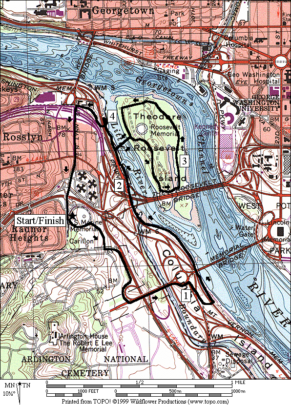
Theodore Roosevelt Island From Iwo Jima Memorial
(4.9 or 3.3 miles, IV or III)
Start with a great view of the river and the major memorials
on the mall. A bike trail follows along Arlington
National Cemetery
and Rte. 110 to Memorial Dr. There, cobblestone streets and bridges take
you over the Boundary Channel toward Memorial
Bridge. When you reach the riverside, take the Mt.
Vernon Trail upriver toward Theodore Roosevelt Island. You can skip the island, but if you do go
there, you find a quiet loop on wooded crushed gravel trails. The loop portion is 1.36 miles around. On one segment, the Swamp Trail, has a 2000ft.
long boardwalk (actually made of recycled plastic). Most of the island is wooded now, similar to
the way Captain John Smith saw it 400 years ago. It was all cleared in the 1800's for
farming.
Despite the good trails, there are some traffic intersections
to watch out for. Near the traffic
circle at Memorial Bridge
you must cross a dangerous intersection without the aid of a traffic light or
stop sign. If you wait, the traffic will
either backup, allowing you to walk in-between the waiting cars, or it will
clear altogether. Turning right from
there, you must cross a similar intersection with and exit ramp. A short way past that, you must cross two
lanes of the George Washington Parkway without a stop sign or traffic light for
the cars. On the return from Roosevelt
Island, a bridge takes you back over the George
Washington Parkway, and traffic lights control
traffic through the business district in Rosslyn.
City
Bridges (6.85, 7.3, or 5.35 miles, VI, VI or IV)
Depending on how you count them, four major bridges cross
the Potomac River into downtown D.C. from Arlington. All of them can be run safely upon, allowing you
to cruise through parks on both sides for your workout. Begin as the Roosevelt Island
loop described above does, by crossing the Boundary Channel to the traffic
circle before Memorial Bridge. Most don=t
realize it but once you cross the channel, not the Potomac,
you=ve already crossed into District
of Columbia territory. The Boundary Channel and the Potomac
define Columbia Island. The whole island is a National Park named and
honoring Lady Bird Johnson. People
line-up all over the island on the Fourth of July to watch the fireworks. After crossing to Columbia
Island, one option follows the Potomac
River shores closely on the Mt. Vernon Trail and passes the Navy
Merchant Marine Memorial. The longer
option crosses the channel four times in all.
It follows the trail along Rte. 27 to the Pentagon N. Parking Lot,
before passing through Lyndon B. Johnson Memorial Grove and crossing the George
Washington Parkway to the Navy Merchant Marine
Memorial. The Navy Merchant Marine
Memorial is depicted as a crashing wave with seagulls dancing in flight above
it.
All options cross over the Potomac River
on the 14th Street
Bridge (George Mason
Bridge) trail and pass by the
Thomas Jefferson Memorial. Next, follow
a trail along Ohio Drive S.
and the Potomac River, passing the Franklin D. Roosevelt
Memorial on the way. The shortest option
goes to the Lincoln Memorial before crossing the Memorial
Bridge back into Virginia. The middle and longer routes continue along
the riverside, past the Kennedy Center
for the Performing Arts. They also goes
through Georgetown on the C&O
Canal Towpath, before returning by crossing the Francis
Scott Key Bridge
into Rosslyn.
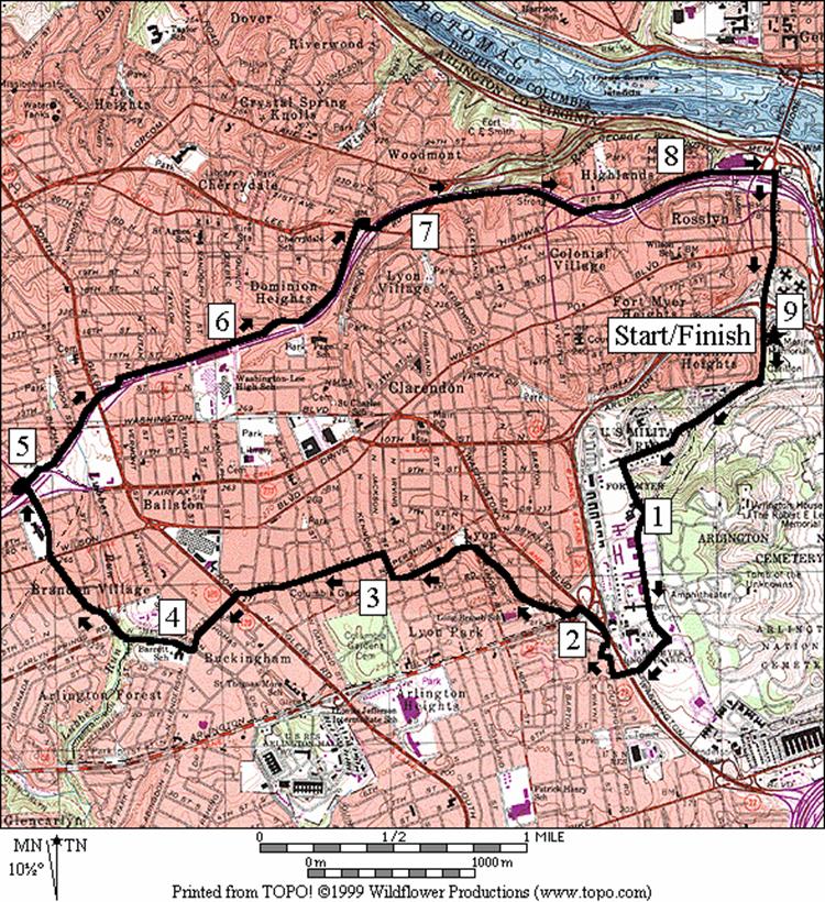
Central Arlington (9.05 miles, IX)
The matured neighborhoods of central Arlington
have several small hidden and pretty parks but even the neighborhoods are
interesting just by themselves. Many of
the houses appear to have been designed individually while others have had
additions added to them that make them unique.
Some were even bought out of Sears and Roebuck catalogues. This route climbs through Ft. Myer,
wanders through the central Arlington
neighborhoods to the Custis Trail, then returns on the Custis Trail most of the
way to the Iwo Jima Memorial.
In Ft. Myer,
just after you enter the gates (you’ll need to show the guard a government
issued picture ID such as a drivers license to enter), there is a large red
building on the right side of Marshall Dr. It once housed the ABuffalo
Soldiers@, 9th
and 10th Calvary and infantry African
Americans who patrolled the west in the 1890's.
In reward for their valor and good service, they were relocated to Ft.
Myer. Leave Ft.
Myer on Carpenter road. After it crosses over Washington Blvd.
it becomes 2nd Street
however the route then goes to the right to parallel Washington
Blvd.
Just after the Rte. 50 underpass, take on a short and
straight paved trail that ends at Lyon
Park. The trail is broken-up by quiet intersecting
streets. The streets names in Arlington
generally confound those unfamiliar with them.
Though generally laid out in a basic grid pattern with numeric street or
road names, they are curved. You rarely
can follow the same road for long without having to navigate around
T-intersections or dead-ends. Stick to
the route until you’re familiar with the other roads. The houses are well taken care of with shrub
and tree filled yards. Upon crossing Glebe
Rd., the neighborhoods become less fancy. On George Mason Dr.
the route passes the Lubber Run Trail head and later crosses the Ballston
Bluemont Junction Trail. Both are
described in other Arlington
sections in this guide.
On the Custis trail, the route parallels Rte. 66 and is
mostly downhill. It is not without some
climbs however. Though not very visible
from the trail, neighborhoods that are passed through such as Maywood,
built from 1909-1913, were part of Washington’s
original trolley suburbs. The Custis
Trail is well designed with bridges over or under intersecting roads, and with
sound barriers or trees to keep the noise and stress levels from the interstate
highway down. Occasional water stops are
available.
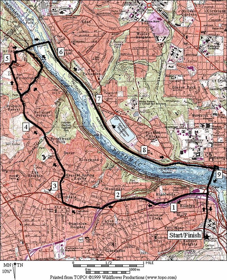
Chain
Bridge (10.2 or 10.3 miles, X)
Chain Bridge crosses the Potomac River
about 2.7 miles north of Georgetown. People gather there during flooding to watch
the raging torrents gnash at the rocks and carry whole trees on by. The bridge connects the northernmost portions
of Arlington to Washington
D.C.
This route goes out the Custis Trail, then along Military
Rd. before crossing Chain Bridge and returning on
the C&O Towpath. The paved Custis
Trail climbs about 200ft. over 1.5 miles.
Military road was cut to
connect Circle Fort Battery defenses built during the Civil War. The operation of the post office on the left
as you turn down the road dates to 1893.
The area was stimulated by the Old Dominion Railroad, in operation from
1906-1935. Today the hilly Military
Road is the address of some of the most expensive
real estate in Arlington. At the end of it, some suburban streets and a
small steep winding paved trail take you to the Chain Bridge.
For variety, the adventurous can leave Military
Rd. earlier and take hillier and steeper hiking
trails to get to Chain Bridge. Though only
one-tenth of a mile longer, this options makes the route considerably more
difficult. First, the Gulf Branch Trail
descends along its namesake stream. A
few stream crossings, some on wet stones, are necessary to cross under the George
Washington Parkway and reach the Potomac Heritage
Trail. The Potomac Heritage Trail is a
long riverside hiking trail that starts off of the Mt. Vernon Trail near Roosevelt
Island. It is blazed and
maintained by the Potomac Appalachian Trail Club. The blazed portion ends at Live
Oak Dr., just outside the Capital Beltway near Langley. Highway construction closed the section of it
from Rosslyn to Potomac Overlook
Park in 1999, during research and
writing for this guide, however I=m
of the opinion that the portion from Potomac
Overlook Park
to the Gulf Branch is too inhospitable for running. Summer humidity, hard rounded blocky slippery
rocks, sand, bugs and stinging nettles are just some of the obstacles. From the Gulf Branch to the Chain Bridge, the
trail improves slightly (just barely enough for running) by being on firmer
ground. It climbs past a small waterfall
(not on this route) however continues up and down near dangerous riverside
cliffs that could prove to be fatal if you took a misstep. Two other tired runners were however, using
the trail when I came through. After
crossing the bridge on a safe footpath take the easy going (flat) C&O
towpath back to Georgetown. From there cross back over the Francis
S. Key Bridge
into Rosslyn and go back to the Iwo Jima Memorial.
Nearby and Connecting Zones
Thomas Jefferson Community Center
Donaldson Run/Potomac Overlook
Regional Park
Bluemont Junction Park
Aurora Hills
Rock Creek Park,
Thompson Boat Center
East Potomac Park
& The Mall
Battery Kemble Park
What to do Afterward
Food and Drink
Tom Sarris Orleans House - prime ribs and steaks - 703
524-2929
Nam Viet Restaurant - 703 522-7110
Agean Taverna - Greek food - 703 841-9494
Madhu Ban - vegetarian - 703 528-7184
Atilla’s - takeout Mediterranean food - 703 525-4976
Entertainment and Edification
The Netherlands
Carillon - south of the Iwo Jima Memorial, concerts April through August -
703 285-2598
Iwo
Jima Memorial Marine Corps Review Parade - Tuesdays 7-8:30PM, June through August - 703
285-2598
Arlington Cemetery
- south of the Carillon
Arlington House
- in Arlington Cemetery
- The Robert E. Lee Memorial - 703 557-0613
Newseum - a museum of news and news coverage - 703 284-3544
or 888-NEWSEUM
Theodore Roosevelt Island - off the
northbound George Washington Parkway
below Rosslyn
Upton Hill
Regional Park
- pool, batting cage and miniature golf - 703 534-3437
4.9
and 3.3 Mile Route
0.0 on
the circle from the bike route dropping from Meade St;
go counter-clockwise around the circle
BR 0.1 bear
R as the road splits to leave the circle
CL 0.25 Marshall
Dr; onto the bike path
CL 0.65 Memorial
Dr (!); Arl Cemetery
on R
0.75 Arlington
Cemetery metro
BR 0.9 traffic
circle
CR 1.05 Rte
27 onto sidewalk & trail; (!)
1.1 exit
ramp X, (!)
BL 1.15 trail
X; R is toward Pentagon
CL 1.25 cross
GW Pkwy (!) onto Mt Vernon Trail
1.4 underpass
Mem Bridge
(! narrow)
1.8 bridge
over Boundary Channel
1.95 underpass
Rte. 50
BR 2.15 at
trail X; L to Roosevelt Br & DC
<*
R 2.25 bridge
to Roosevelt Island (parking)
R 2.35 at
T after crossing bridge
L/R 2.4 L at
trail X on R; R at memorial on L
2.6 trail
X on R (unmarked)
2.7 Upland
Trail on L (water/restroom)
2.8 bridge
underpass and trail X on R; plastic boardwalk ahead is the Swamp Trail
2.95 trail
X on L to Lookout Pt
BL 3.4 at
trail X on R to river; Upland Trail on L just ahead also
3.45 water
fountain
L 3.55 trail
X before river
R 3.7 to
bridge into Virginia
R 3.8 Mt.
Vernon Trail (parking)
>*
4.0 Heritage
Trail on R before ramp/bridge over GW Pkwy
L 4.25 Lynn
St; to Key Bridge
into Georgetown, DC
(Custis Trail is S)
4.5 Wilson Blvd
4.7 Rte
50 overpass
L 4.85 trail
X on L to Memorial circle
4.9 Iwo
Jima Memorial circle
City Bridges
Distance: 6.85, 7.3, or 5.35 miles
Rating: VI, VI or IV; mostly paved trails
with some sidewalks & traffic intersections
6.85 Mile Route
0.0 on the circle from the bike route dropping
from Meade St; go counter-clockwise
BR 0.1 bear R as the road splits to leave the
circle
CL 0.25 Marshall Dr; onto the bike path
CL 0.65 Memorial Dr (!); Arl Cemetery on R
0.75 Arlington Cemetery metro
BR 0.9 traffic circle after X Boundary Channel
CR 1.05 Rte 27 onto sidewalk & trail; (!)
1.1 exit ramp X (!)
<*
BL 1.15 trail X; R is toward Pentagon
CR 1.25 GW Pkwy X
(!); Mt Vernon Trail
1.85 Navy Merchant Marine Mem parking
>*
R 2.15 trail X on R unmarked to 14th St Bridge
2.7 end 14th St Bridge; stairs on L
L 2.8 L at trail X on L & CL on road; Jeff
Mem
R/L 2.95 Ohio Dr S; R onto Inlet Bridge; L onto trail along Ohio Dr S (water at 3.2 & 3.4)
<**
BL 3.7 circle before Independence Ave
3.9 underpass Memorial Bridge (water 4.1)
CR 4.2 N. Parkway Dr
5.0 underpass Whitehurst Frwy
L 5.1 C&O Towpath (red brick walkway)
5.3 C&O Canal Visitor Center
(water/restroom)
R/L 5.75 R up the ramp at 3rd foot bridge
over the canal to the L; L at top of stairs
L 5.8 onto Francis Scott Key Bridge
6.2 Mt. Vernon Tr on L; Custis Tr on R
L 6.85 bike route down to Iwo Jima Memorial

*7.3 Mile Route
BR 1.15 trail X; L is to Mt Vernon Tr
1.2 cross on-ramp, traffic (!)
1.45 cross Boundary Channel
BL 1.55 ramp to Pentagon N parking lot
L 1.65 perimeter road Pentagon N parking lot
R/L 1.7 R to LBJ Mem Grove parking (water); L over
bridge to cross Boundary Channel
R 1.95 trail X on R to parking; then S
L 2.1 trail X on L to exit parking
L/R 2.2 to xwalk; cross GW Parkway (!)
R/L 2.25 after X GW Parkway; Navy Merchant Marine Memorial parking
R 2.3 Mt Vernon Trail (pickup cues at mile 2.15
on 6.85 mile route)
**5.35 Mile Route
XS 3.65 at crosswalk before circle
3.7 Independence
Avenue
L 3.75 circle at the Lincoln Memorial
L 3.85 Memorial Bridge
BR 4.3 trail X on R; go clockwise around the
circle; on Memorial Dr; toward Arl Cemetery
R 4.7 trail head on R; after bridge & metro
R 5.1 road to Iwo Jima Memorial
L 5.25 Iwo Jima circle
5.35 paved bike route to Meade St
Central Arlington
Distance: 9.05 miles
Rating: IX; paved trails, sidewalks and
residential roads; early climb
0.0 from
the circle, go up the bike path to Meade St.
L 0.0 Meade St.
R 0.15 Marshall
Dr. (into Ft Myer B govt ID
or driver=s license
required) (hill)
0.3 trail
X on L to picnic area & chapel
CL 0.75 Lee Ave
R 1.0 McNair
Rd (just past HQ)
R 1.5 Carpenter
Rd (leave Ft Myer and cross over Washington Blvd)
R 1.75 Courthouse Rd
L/R 1.85 L on
Walter Reed; R on Wayne St
R/L 1.9 sidewalk
at end of Wayne goes to Washington
Blvd
2.05 underpass
Arl Blvd, Rte 50
L 2.1 Arlington
Blvd Trail (unmarked)
R 2.15 trail
X on R (unmarked) into park
2.3 trail
ends at 1st Rd
and continues at Cleveland St
BR 2.55 trail
ends; bear R on access road to Fillmore St
L 2.6 onto
4th St; Lyon
Park on R
2.95 4th
St bears R & becomes Jackson
St
L 3.05 5th St
3.4 Oakland St
3.6 5th
St ends; continue S on sidewalk
BL 3.65 Henderson
Rd; cross Glebe Rd at TL
CR 3.9 George Mason Dr
4.15 Lubber
Run trail head on L
4.55 Ballston
Bluemont Junction Trail at Wilson Blvd
L 4.85 10th St;
after I-66 overpass
L 4.9 spur
trail on L to Custis Trail; L on Custis Trail
5.05 Ballston
Bluemont Junct Trail on R
R 5.5 at
T to stay on trail after underpass of Glebe Rd & overpass ramp from I-66
6.0 trail
X on L to Quincy St; water
6.15
6.7 Mile
Marker 2.5; bridge over Lee Hwy;
trail X on L to Maywood
BL 6.8 at
bottom of winding hill to stay on trail; Lee Hwy
on R; shopping is S
7.0 trail
X on R to Spout Run Pkwy
L 7.6 at
T to stay on trail at Lee Hwy;
cross over I-66
CR 8.4 Lynn
St; end of Custis Trail; S is to Mt. Vernon Trail
8.85 cross
over Rte 50
L 9.05 bike
route to Iwo Jima Mem circle
Chain Bridge
Distance: 10.2 or 10.3 miles
Rating: X; paved trails, sidewalks,
residential roads, and towpath; hilly first three-quarters
10.2
Mile Route
0.0 from
the circle, go up the bike path to Meade St.
R 0.0 Meade St
0.15 Arlington Blvd
(Rte 50) overpass
L 0.65 Custis
Trail on sidewalk w/yellow line along Lee Hwy
(Rte 29);
Mt
Vernon Trail is on the R
1.2 Scott
St; asphalt trail begins
BR 1.45 after
bridge over I-66 to stay on trail
L/R 2.2 bear
L to leave the Custis Trail; then immediately turn R on Lee
Hwy (before the I-66 underpass & winding hill)
CR 2.8 Military
Rd; Quincy Rd is on L
3.15 Lorcom
La
3.55 Marcey Rd on R
3.8 Donaldson
Run Trail on L
<*
4.5 Gulf
Branch Trail; Nature Center
R 4.95 N
Old Glebe Rd; don’t take ramp down to N Glebe Rd
L 5.1 Randolph St
R 5.25 paved
trail head on R; (! steep downhill); continue on 41st
St
L 5.4 N Glebe Rd (Rte
120)
>*
5.45 begin
Chain Bridge
L 5.75 ramp
on L down to C&O Towpath
R 5.8 C&O
Towpath under Chain Bridge
6.3 stairs
on R to Crescent Trail (trestle)
6.8 ramp
to Fletcher’s Boat House; Crescent Tr (water/restrooms/snacks)
8.5 stairs/ramp
to Glover Archbold Trail
9.0 F.
S. Key Bridge underpass
L 9.05 bridge
crosses canal; up stairs; L at top of stairs; continue climbing
L 9.1 Francis
Scott Key Bridge
9.55 Custis
Tr on R; Mt Vernon Tr on L
10.05 Arlington Blvd
(Rte 50) overpass
L 10.2 bike
route to Iwo Jima Mem circle
*10.3
Mile Route
R 4.5 Gulf
Branch Trail (begins near bottom of hill on driveway for pumping station; continue down along the
stream, crossing (!) where needed; follow white blazes
4.75 trail
X on L to Nelson St & 36th
Rd
L 5.15 Potomac
Heritage Trail (triangle X) after underpass GW Pkwy;
follow blue blazes up steep hill; dangerous cliffs next 0.3 miles (!)
5.45 trail
goes under GW Pkwy
CR 5.5 N
Glebe Rd at 41st St
(pickup cues at mile 5.45 on 10.2 mile route)