Thomas Jefferson Community Center


One of the advantages of living in Arlington is that you can use the Thomas Jefferson Community Center all winter long. The large field house with an indoor track, is used nightly by runners, basketball players (three or four full court games at a time), weight lifters, aerobics classes, volleyball clubs, and special classes–all at the same time. It’s a veritable zoo, but can be a fun one. The facility has a wood shop, photo lab, showers and other amenities. Other functions such as classes and pet shows are held there too. Due to its popularity, residents must pay a fee and non-residents are no longer allowed to use the indoor facilities. 


Winter is not the only time to use the center however. As just about anywhere in Arlington, paved trails are not far away and open to all. The closest is the unnamed trail along Arlington Blvd., convenient for connection Ft. Myer or to the Washington and Old Dominion Trail (W&OD). Other trails and places like Lubber Run are in reach too.


Getting There


From Northern Fairfax County, VA or Montgomery County, MD

Exit the Capital Beltway onto Rte. I-66, headed east. If you’re coming from Montgomery County or the northernmost parts of Fairfax County, you will have to use the Washington and Dulles Access Expressway for 2.7 miles to get onto Rte. I-66; it’s a left exit off the beltway. After 6.1 or 4 miles on Rte. I-66 respectively, exit onto Fairfax Dr. Turn right soon after the exit ramp onto North Glebe Rd. Follow it 1.3 miles. Just after crossing over Rte. 50, turn left on 2nd Street. Turn left again into the community center parking lot. Start from the sidewalk on the right side of the building when facing it from 2nd Street.


From Southern Fairfax County, VA

Exit the Capitol Beltway, I-95, northbound onto Henry G. Shirley Highway (I-395). After approximately 7.5 miles, exit toward Rte. 27. Stay in the left lanes and merge ontoWashington Blvd. Once on Washington Blvd., pass the Columbia Pike exits, then take the second cloverleaf exit onto 2nd Street. The turn is just after the 2nd Street overpass; before the Rte. 50 interchange. Follow 2nd Street headed west, turning right after 0.7 miles into the community center parking lot. Start from the sidewalk on the right side of the building when facing it from 2nd Street.


From Prince Georges County, MD

Use the Capital Beltway (I-95), to get to Rte. 50 west or I-295 north. From either, take the westbound Southeast Freeway (I-395) after 11 miles or approximately 6 miles respectively. Follow the Southeast Freeway across the river into Virginia. Do not use the express lanes. Stay in the third lane from the right, pass some early exits, then follow the signs onto Washington Blvd. Pass the Columbia Pike exit, then take the second cloverleaf exit onto 2nd Street. The turn is just after the 2nd Street overpass; before the Rte. 50 interchange. Follow 2nd Street headed west, turning right after 0.7 miles into the community center parking lot. Start from the sidewalk on the right side of the building when facing it from 2nd Street.


Area Routes


Lubber Run from Thomas Jefferson Community Center (5, 4.05 or 3.9 miles, IV or III)

Much of Arlington was developed long ago. Some of it is nice; some of it isn’t. When you descend into the Lubber Run stream valley however, the air changes. If it was hot and sunny getting there, you’re rewarded with it feeling cool and shady and green. This route offers three options to get there. All return on the trail along Arlington Blvd., Rte. 50. The longest goes out along Rte. 50 headed east, in the opposite direction from Lubber Run, then utilizes a small trail in Lyon Park to turn around. The second longest route joins the longest by using residential streets through quiet neighborhoods. The shortest, goes out the Rte. 50 trail headed west, then uses streets to join the other options. Once in Lubber Run, the paved trail descends crossing back and forth over the creek, and past an amphitheater. The trail is short, and climbs at the end to the Arlington Blvd., Rte. 50, access road. The trail back along Rte. 50 is paved but occasionally discontinuous, requiring you to use the side street or sidewalks. Because of the proximity to the noise of Rte. 50, not all of the trail is pleasant, but some parts are protected by trees a little.


Arlington Boulevard (4.3 miles, III)

The trail along Arlington Blvd. is the most direct way to get to the W&OD Trail from the

community center. Most of it is sunny however, and sometimes you must use the access road or a sidewalk when the trail stops temporarily. It’s not hilly but eventually descends into the Four Mile Run valley to join the W&OD Trail. The paved W&OD Trail is a converted railroad grade trail, that once was called the longest and skinniest park in the country. See further descriptions of it in the Bluemont Junction Park section of this guide. Follow the W&OD downhill further toward Columbia Pike. On the sides below the trail, see the rocky portions of Four Mile Run.  It’s stocked with trout in the spring for youth fishing. You will also pass a small wetland area on the left, before turning left, leaving the W&OD Trail to go uphill; back toward the community center. The route back is mostly on residential roads. Though there is a county designated bicycle route, also on roads, back to the community center from the W&OD trail, this route is different. It parallels the county route but uses more direct, quieter and less hilly roads.  Around


Arlington National Cemetery (7 miles, VII)

The grounds of Arlington National Cemetery are beautiful. It’s one of the most sought after burial grounds by those who have served the country in the military. There are roads in the cemetery that are often used by runners, however technically, neither running nor bicycling are permitted inside. As an alternative you may circle the grounds and still see some of it. Though not as pretty as within the cemetery, there are interesting places next to it. Along Columbia Pike, near the Navy Annex Building, there is a sweeping view of Washington D.C. from a hilltop.  Dropping down the hill, pass the Pentagon on the way toward Memorial Bridge. From there pass near the main entrance gates of Arlington Cemetery, then start climbing within view of the Carillon, and the Iwo Jima Memorial. Continue the climb through Fort Myer (the hill from Rte. 110 to Lee Ave. in Ft. Myer rises about 200 vertical feet over 0.85 miles) Just after you enter the gates, (you’ll need a government issued picture ID such as a drivers license to enter), on the right side is a large red building. It once housed the “Buffalo Soldiers”. (see the section on the Iwo Jima Memorial in this book for further descriptions). On this route, there are a few bad traffic intersections near Memorial Bridge. They can be safely crossed but only with patience.
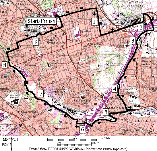
 

South Arlington (9.8 miles, IX)

This loop starts like and includes the view of Washington D.C. described above in the Around Arlington National Cemetery route. Since a lot of it is on street sidewalks, its not the prettiest route in Arlington but it does connect several trails and convenient gathering places. Using Army Navy Drive and a small trail along the Long Branch creek, the route reaches the Four Mile Run Trail. The Four Mile Run Trail is one of the major trails in Arlington. It follows its namesake waterway about 7 miles from the Potomac River and National Airport, nearly to the East Falls Church metro station. After a few miles from the Potomac, it eventually parallels the W&OD Trail, sometimes sharing the same path in places. A brief segment of the Four Mile Run Trail, on this route, uses sidewalks in Alexandria, before crossing the Shirley Highway into Shirlington. Part of the Four Mile Run Trail after Walter Reed Dr. is wooded and a bit isolated compared to the rest of the route. That part is closed after dark for safety; as are many other parks in the Washington area. After crossing under Columbia Pike residential streets take you back to the community center.


Nearby and Connecting Zones

Iwo Jima Memorial

Bluemont Junction Park

Aurora Hills

East Potomac Park & The Mall

Cameron Run Regional Park


What to do Afterward

Food and Drink

Carlyle Grand Café - 703 931-0777

Crystal Thai - 703 522-1311

Attilla’s - take out Mediterranean food - 703 920-4900

Brenner’ Bakery of Arlington - 703 920-6333

Outback Steakhouse - 703 5277-0063

Entertainment and Edification

Signature Theatres - 703 820-9771

Arlington Cinema ‘n’ Drafthouse - eat, drink and watch a movie or game - 703 486-2345
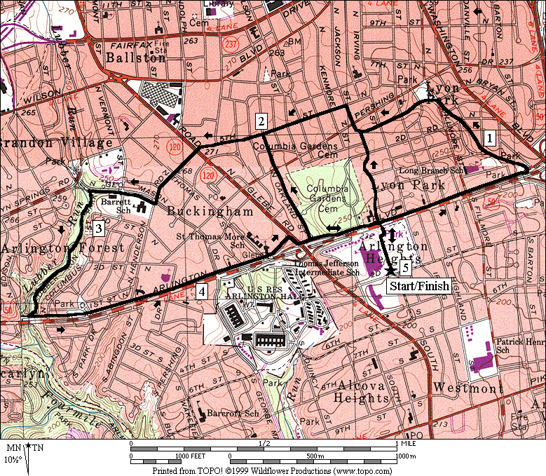
 

Lubber Run from Thomas Jefferson Community Center

Distance: 5.0, 4.05 or 3.95 miles

Rating: IV or III; paved trails and residential streets


5.0 Mile Route


0.0       from TJCC & 2nd St; north on the sidewalk/bike trail toward Rte 50


L/R      0.15     after the trail bears R, L to the footbridge over Rte 50; R after the bridge on the ramp to the trail

<*

BL       0.25     paved trail along Arl Blvd, Rte 50

0.55 Filmore St


CL       0.8       cross Rte 50 exit ramp, turn L, and turn L again on the trail X on the L to

the small park

0.95     trail ends at 1st Rd and continues at Cleveland St


BR       1.2       trail ends; bear R on access road to Fillmore St


L          1.25     onto 4th St; Lyon Park on R

1.55     4th St bears R & becomes Jackson St

>*

L          1.7       5th St

2.0       Oakland St

>**

2.25     5th St ends; continue S on sidewalk


BL       2.3       Henderson Rd; cross Glebe Rd at TL


CR       2.55     George Mason Dr


L          2.75     Lubber Run trail head on L


BR       2.85     wooden bridge at the trail split

2.95     wooden bridge on L over the creek

3.0       cross the creek; go behind the amphitheater (water/restrooms)

3.05     wooden bridge on R

3.15     wooden bridge on R


L          3.35     Arl Blvd access road; then the paved trail; becomes Cathedral La

4.05     George Mason Dr


R          4.35     N Glebe Rd


L          4.4       sidewalk along Arl Blvd exit ramp

4.5       trail X on L to Oakland St & VA Sq


UL       4.75     ramp to footbridge after crossing Jackson St; cross over Rte 50


BR       4.85     at trail X; go toward sidewalk

5.0       2nd St; TJ Comm Center


*4.05 Mile Route


UR       0.25     Arl Blvd, Rte 50 trail

<**

R          0.25     Jackson St

BL       0.6       to stay on Jackson St at 4th St (pickup cues at mile 1.7 on 5.0 mile route)


**3.95 Mile Route

R          0.5       trail X on R to Oakland St & VA Sq

0.8       Pershing St

L          0.95     5th St (pickup cues at mile 2.25 on 5.0 mile route)


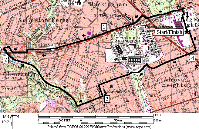
Lubber Run From Thomas Jefferson Community Center


Arlington Boulevard

Distance: 4.3 miles

Rating: III; paved trails with some sidewalks & residential streets


0.0       from TJCC & 2nd St; north on the sidewalk/bike trail toward Rte 50


L/R      0.15     after the trail bears R, L to the footbridge over Rte 50; R after the bridge on the ramp to the trail

<*

UR       0.25     paved trail along Arl Blvd, Rte 50; near Jackson St

0.5       trail X on R to Oakland St/Va Sq


CR       0.55     N Glebe Rd


CL       0.6       Cathedral La; use the shoulder, then the footpath

0.95     George Mason Dr

1.65     Lubber Run Trail on R


L/R      1.7       at Edison St; continue along Rte 50 on the sidewalk


R          1.8       Granada St


L          1.85     N Greenbriar St

1.9       trail head at end of street


L          1.95     W&OD Trail; under Rte 50 overpass

2.0       Four Mile Run Trail on R goes uphill

2.6       Mile Marker 2


L          2.75     trail X on L unmarked & unpaved to 7th St; uphill


L          3.0       Wakefield St


R          3.1       6th St

3.35     George Mason Dr; go S toward Foreign Affairs Training grounds


R          3.4       paved trail (unmarked)

3.5       trail X on R; Timber Challenge


R          3.6       Quincy St


L          3.7       6th St; trail X on R to park

4.0       S Glebe Rd


L          4.05     Jackson St


CL       4.25     2nd St

4.3       TJ Community Center


Arlington Boulevard


Around Arlington National Cemetery

Distance: 7.0 miles

Rating: VII; street sidewalks and paved trails; sunny with a big hill on the return


L          0.0       from the parking lot, head east on 2nd St

0.35     Filmore St


CR       0.75     Courthouse Rd

L          1.25     Columbia Pike

1.65     Washington Blvd (underpass)

2.25     Joyce St


BL       2.55     BL at the Pentagon parking lot; follow the sidewalk toward the Pentagon


CL       2.65     sidewalk along the ramp toward Rte 27; begin to circle around the Pentagon


BL       2.85     at the Pentagon gate; continue following along Rte 27 leaving the Pentagon


CL       3.25     ramp from Pentagon North Parking; continue following along Rte 27

3.65     highway ramp X (!)

3.7       trails merge; R is to the river and the Mt Vernon Trail

3.75     highway ramp X (!)

L          3.8       clockwise around the circle at Memorial Bridge; (!) cross Rte 27


L          3.9       Memorial Dr; toward Arlington National Cemetery


R          4.15     trail head on R; after bridge & metro


XS       4.55     road to Iwo Jima Memorial on R; trail ends; use shoulder (!)

4.7       gate to Ft Myer (govt ID or driver’s license required); continue up steep hill

4.8       trail X on L to picnic area & chapel


CL       5.3       Lee Ave


R          5.5       McNair Rd (just past HQ)


R          6.05     Carpenter Rd (leave Ft Myer and cross over Washington Blvd)

6.3       Courthouse Rd

6.65     Filmore St


R          7.0       TJ Comunity Center


Around Arlington National Cemetery


Southern Arlington

Distance: 9.8 miles

Rating: IX; street sidewalks and paved trails


L          0.0       from the parking lot head east on 2nd St

0.35     Filmore St


CR       0.75     Courthouse Rd


L          1.25     Columbia Pike

1.65     Washington Blvd (underpass)


CR       2.25     Joyce St


CR       2.65     Army Navy Dr (after I-395 underpasses)

2.75     Lynn St on L


CL       3.9       unmarked road before Fraser Park; becomes 28th St


R/L      4.1       R on 26th St; L into parking for pool after crossing creek; trail at 4.15


L          4.25     Troy St

4.3       trail X to wooden bridge on L


L          4.45     S Glebe Rd; cross creek on bridge


UR       4.55     cross S Glebe Rd at TL for Meade St; R again after crossing


BL       4.6       onto the Four Mile Run Trail; don’t turn L; stay along S Glebe Rd


CL       5.0       W Glebe Rd


R          5.15     Valley Dr


BR       5.3       Martha Custis Dr


R          5.7       Gunston Rd; footbridge over I-395


R          5.95     28th St


R          6.1       Randolph St


CL       6.15     Arl Mill Dr; onto the paved Four Mile Run Trail


CL       6.65     Walter Reed Dr


R          6.7       Four Mile Run Tr; small stone bridge


L/R      7.45     trail splits; L to George Mason & bridge over creek; R is to underpass


R          7.5       Four Mile Run Trail; after bridge


BL       7.95     downhill to creek and underpass; trail X on R to Columbia Pike


R/L      8.1       trail X on R up; L on W&OD Trail


R          8.25     trail X on R unmarked & unpaved to7th St; uphill


L          8.5       Wakefield St


R          8.6       6th St

8.9       George Mason Dr; go S


R          8.9       paved trail (unmarked)


R          9.1       Quincy St


L          9.15     6th St; trail X on R to park

9.5       S Glebe Rd


L          9.6       Jackson St


CL       9.75     2nd St

9.8 TJ Community Center


Southern Arlington