Aurora Hills
Aurora Hills is
neighborhood near Crystal City and Pentagon City. Ball
fields, ball courts, a very short trail, and a combination Library/Fire Station
are the central pieces of a recreation center there. The area is convenient to
those working in the nearby Crystal City high
rises. Also nearby, are a growing number of enjoyable restaurants. Aurora Hills is in Arlington but close
enough to Alexandria, to use
not only the Four Mile Run Trail, but also the Wayne F. Anderson Trail, which
parallels on the other side of Four Mile Run. It’s also close to National Airport and the
Pentagon so that loops involving the Mt. Vernon Trail can be made.
Getting
There
From
Northern Fairfax County, VA or Montgomery
County, MD
Exit the
Capital Beltway onto Rte. I-66, headed east. If you’re coming from Montgomery County or the
northernmost parts of Fairfax County, you will
have to use the Washington and Dulles Access Expressway for 2.7 miles to get
onto Rte. I-66; it’s a left exit off the beltway. After 9.8 or 7.7 miles on
Rte. I-66 respectively, just after the tunnel at Rosslyn and before crossing
into Washington D.C., exit
right, onto Rte. 110. Turn right after 2.2 miles at the I-395 interchange as if
you were taking I-395 north into D.C. While still on the cloverleaf, bear left
onto Army Navy Dr. After
only 0.35 miles, turn left onto Hayes St. After
passing the Fashion Center Mall on your right, and after passing 15th
Street, turn
right into the Aurora Hills Library and Recreation Center parking
lot. Turn right and park near the paved trail head on the left.
From
Southern Fairfax County, VA
Exit the
Capitol Beltway, I-95, northbound onto Henry G.
Shirley Highway (I-395). After approximately
7.5 miles, exit toward Rte. 27. Stay in the right most lanes following signs to
Pentagon City and Hayes St. At the
end of the exit ramp, go straight at the stop light. Pass the Fashion Center
Mall on your right, and then 15th
Street. Turn
right into the Aurora Hills Library and Recreation Center parking
lot. Turn right and park near the paved trail head on the left.
From Prince Georges County, MD
Use the
Capital Beltway (I-95), to get to Rte. 50 west or I-295 north. From either,
take the westbound Southeast Freeway (I-395) after 11 miles or approximately 6
miles respectively. Follow the Southeast
Freeway across the river into Virginia. Do not
use the express lanes. Stay in the left lane on the bridge over the Potomac
River. After the bridge, make the left exit to Rte. 1, into Crystal City. Exit the
Rte. 1 freeway on the right at 15th
Street, turning
right at the stop light. After three blocks, turn left on 15th
Street. Turn
right into the Aurora Hills Library and Recreation Center parking
lot. Turn right and park near the paved trail head on the left.
By Metro
Rail
Ride metro
rail’s Blue or Yellow lines to the Pentagon City station. Exit
onto Hayes Street and head
south toward 15th Street. As you
cross 15th Street, walk
through the parking lot on the right until you see the paved trail head on the
right. The distance from the station is 0.23 miles.
Area
Routes
Around Aurora Hills (7.15 or 7.55
miles, VI)
This
circumnavigation of the Crystal City and Pentagon City takes
advantage of several trails including the Mt. Vernon Trail and the Four Mile Run
Trail. Begin by going through the park. The short trail ends after less than a
quarter mile. Start the loop using Army
Navy Dr. to go around Arlington Ridge (a hill).
Army Navy Dr. is not
very aesthetically pleasing. It parallels I-395, passes an entrance to Army
Navy Country Club, but then connects with another short trail that parallels Long
Branch (a creek). After the trail, you must cross
S. Glebe Rd. at a
traffic light, but shortly after reaching the Four Mile Run Trail, you have an
option to cross into Alexandria and use
the Wayne F. Anderson Trail, on the other side of Four Mile Run. Both trails
parallel Four Mile Run and join near Jefferson
Davis Hwy, Rte 1. The Wayne F. Anderson Trail passes
a small wetland area and some ball fields. The Four Mile Run Trail stays closer
to the water, but passes a water treatment plant. After both routes are joined,
cross under the bridges for the highways, the railroads, the metro, and the George
Washington Parkway before reaching the Mt.
Vernon Trail. People often fish under the bridges and foot or bicycle traffic
is frequent on weekends, but you may feel the need to go under the bridges with
others for safety reasons. On the Mt.
Vernon Trail, you can see some of the jets in the airport at first but as you
head north, paralleling the George
Washington Parkway, the airport terminal and a
hill obstruct the view. Carefully cross
a few exit ramps before turning off on a side trail to return to Crystal City. In the
year 2000, new bridges were added over the worst of the airport exit/entrance
ramps. On the side trail, a short tunnel takes you from the airport under the
roads and railroad, putting you on Crystal
Dr., near the Virginia Railway Express
commuter railway station. Follow along Crystal
Dr. through Crystal City, passing
the water park, and complete the loop on Army
Navy Dr.
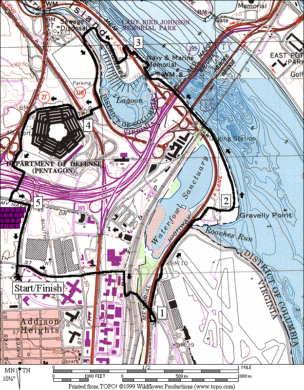
Pentagon (5.4 miles, IV)
A lot of Washington area
runners work in the Department of Defense. The Marine Corps Marathon and the
Army Ten-Miler (open to all) are two of the areas most popular races which are
often routed on some parts of this run. Small crowds can be seen filling the
trails before, during, and after work hours around the Pentagon. On weekends, the Pentagon’s North Parking Lot
is an informal gathering place for runners cyclists and in-line skaters.
This route
takes the Mt. Vernon Trail past Gravelly Point where commercial jets roar only
200-300 feet overhead as they land and take-off at National Airport. Passing
under the 14th Street Bridges
along the Potomac River, follow the Mt. Vernon Trail over another
bridge onto Columbia Island (actually
part of the District of Columbia) to the
Navy Merchant Marine Memorial in Lady Bird Johnson Park. Cross
the George Washington Parkway
(difficult during commuting hours) to the Lyndon B. Johnson Memorial Grove.
Pine trees and azaleas grace the grounds before a bridge allows you to cross
back over the Boundary Channel into Virginia at the
Pentagon North Parking Lot. Go up to the River Entrance of the Pentagon, then
counterclockwise around it. The route
passes the part of the Pentagon which was struck by a commercial jet during the
attacks on September
11, 2002. Upon reaching the South
Parking lot, circle around the lot, similar to the route the Marine Corp
Marathon sometimes uses, but turn right to go through the tunnel (no cycling in
the tunnel) under Shirley Highway, Rte.
I-395. Return on Hayes St. to the
parking at Aurora Hills.
Nearby
and Connecting Zones
Iwo Jima Memorial
Thomas Jefferson Community Center
Daingerfield Island
Cameron Run Regional Park
East Potomac Park & The Mall
What
to do Afterward
Food and
Drink
Portofino’s - 703
979-8200
Café
Italia - 703 521-2565
Top Thai
Restaurant - 703 521-1305
Cha Cha’s
Seafood Bistro - 703 979-7676
Entertainment
and Edification
Arlington
Historical Society - 1805 S Arlington Ridge Rd. - 703
892-4204
Gunston
Theatres One and Two - 703 228-6960
Birchmere
- live folk music just over the Alexandria border -
703 549-5919
Washington
Shakespeare Company - 703 418-4807
Gravelly
Point - view the airplanes take-off and land at the airport
Around
Aurora Hills
Distance:
7.15 or 7.55 miles
Rating:
VI; paved trails and street sidewalks
7.15
Mile Route
0.0 take the trail
through the park
CR 0.2 Joyce St
BL 0.35 at
15th St X; to stay on Joyce St
L 0.65 Army Navy Dr (before
I-395 underpass)
0.8 Lynn
St on L
CL 1.9 unmarked
road before Fraser Park; becomes 28th
St
R/L 2.1 R
on 26th St; L into
parking for pool after crossing creek; trail at 2.15
L 2.25 Troy St
2.3 trail X to wooden
bridge on L
L 2.5 S
Glebe Rd; cross creek on bridge
UR 2.55 cross
S Glebe Rd at TL for
Meade St; R again
after crossing
UL 2.6 onto
the Four Mile Run Trail
>*
BR 2.95 trail
X (triangle); after underpass
BR 3.1 at
split in trail; L is to S Glebe Rd
3.55 Eads
Rd on L
R 3.65 at
T; go under bridges along water
>*
BR 4.0 Mt
Vernon Trail
L 5.05 trail
X on L to Crystal City after
bridge for trail over entrance ramp
R 5.35 Crystal Dr; Crystal Water Park
5.4 VRE commuter
station on R
5.5 15th
St on L
5.65 road bends L and
becomes 12th St
CR 5.85 Dale St; becomes Army
Navy Dr
6.3 Hayes St;
shopping mall
6.4 trail to tunnel
to Pentagon on R
L 6.5 Joyce St
BR 6.85 at
15th St to stay
on Joyce St
L 7.0 trail
head on L into park
7.15 parking

*7.55
Mile Route
L 2.95 trail
X (triangle); after underpass
L 3.0 Mt
Vernon Ave; bridge over creek
L 3.05 Wayne
F Anderson Trail head
3.25 trail X on R
3.6 bridge; wildlife
sanctuary on L
3.75 Commonwealth Ave on R
L 3.95 Jeff Davis Hwy, Rte 1
L 4.0 trail
on L after bridge
UL 4.05 Four
Mile Run Trail (pickup cues at mile 4.0 on 7.15 mile route)
Around Aurora Hills
Pentagon
Distance:
5.4 miles
Rating:
IV; paved trails and sidewalks and Pentagon parking lots
0.0 head north
through the parking lot toward 15th
St
R 0.1 15th St
0.55 underpass Jeff
Davis Hwy, Rte 1
CR 0.7 Crystal Dr
0.75 VRE commuter
station on L
L 0.85 connector
trail (tunnel) to the Mt. Vernon Trail; Crystal Water Park
BL 1.1 Mt
Vernon Trail
1.35 Mile Marker 14 on
bridge over airport exit ramp
1.85 entrance driveway
for Gravelly Point
2.45 Mile Marker 15
2.75 trail X on L to 14th
St Bridge
2.85 bridge over
Boundary Channel; trail X on L (cuts short 0.06 miles)
L 3.05 Navy
Merch Marine Mem parking
R/L 3.05 along
GW Parkway to xwalk
L/R 3.1 cross
GW Parkway (!) into Lyndon B Johnson Memorial Grove Park
R 3.2 through
parking lot to trail head
L 3.35 at
T (unmarked)(water at 3.45)
3.5 begin bridge over
Boundary Channel
L 3.55 after
bridge to Pentagon N Parking; bear L at parking (water); use grass
R 3.9 cross
road before the flag pole to the stairs; sign Pentagon River Entrance
L/R 3.95 up
the stairs and across the courtyard
R 4.05 Pentagon
River Entrance; begin counter clockwise around the Pentagon
BL 4.35 gate;
continue around the Pentagon along Rte 27
R 4.55 cross
the exit ramp to the sidewalk; go counter-clockwise around the Pentagon South
parking lot
4.6 Columbia Pike on
R
R 4.75 tunnel
under I-395; no cycling
BR 4.85 after
the tunnel to the xwalk & TL
CL 4.9 Army
Navy Dr; shopping mall
R 5.0 Hayes St
5.2 Pentagon City metro
station
5.35 cross 15th
St into
parking lot
5.4 parking lot trail
head on R
Pentagon