Cameron Run Regional Park
For a long time, the flood plane around Cameron Run was
regarded by most as just another industrial zone. Railroads and metro lines track through
it. No one lived there and few things
even grew along the waterway. Cameron
Run is clearly visible from the Capital Beltway on your right as you drive
clockwise from Route 1 in Alexandria. A different vision held by the Director of
the City of Alexandria Transportation
and Environmental Services Division is changing the area. Trees were planted. A small lake was created in 1985 as a place for urban trout
fishing. It was eventually named Lake
Cook in honor of that
Director. The lake forms the backdrop of
Cameron Run
Regional Park, that is probably still better known for its wave pool,
water slides, batting cage, and miniature golf course. Holmes Run is a tributary to Cameron
Run. A paved trail follows along both
watercourses from Old Town Alexandria, to near Bailey=s
Crossroads.
Getting There
By Automobile
Take Exit 3A off the Capital Beltway, Rte. I-95, onto
Clermont Dr.; the Eisenhower Ave. Connector road. If your coming
clockwise around the beltway turn right at the stop at the end of the ramp; if
coming counterclockwise around the beltway, turn left at the stop at the end of
the ramp. Next, turn right on Eisenhower
Ave. After
0.6 miles, turn left into the Cameron
Run Regional Park
parking lot. Start on the trail along
the road near the entrance to the park.
By Metro
The Eisenhower Ave.
metro station is approximately 1.85 miles from Cameron
Run Regional Park. Follow Eisenhower
Ave. west from the station to get to the park, or
just start the routes from the station.
Area Routes
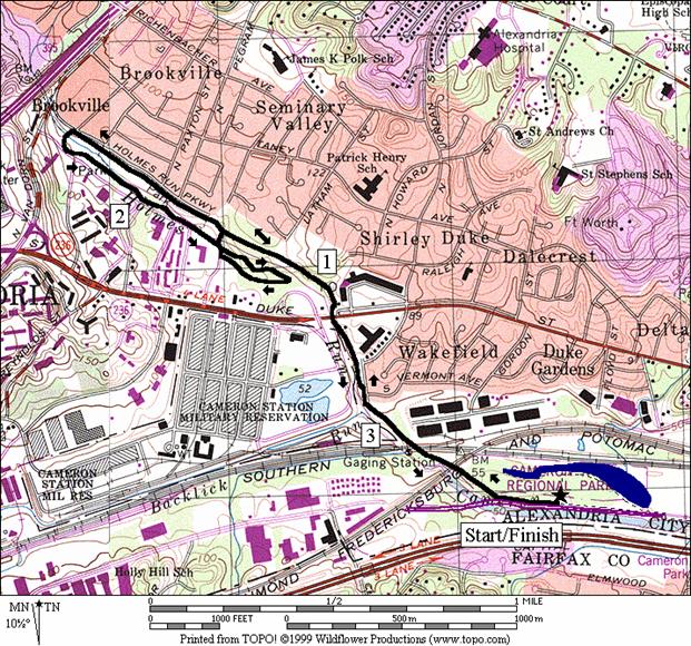
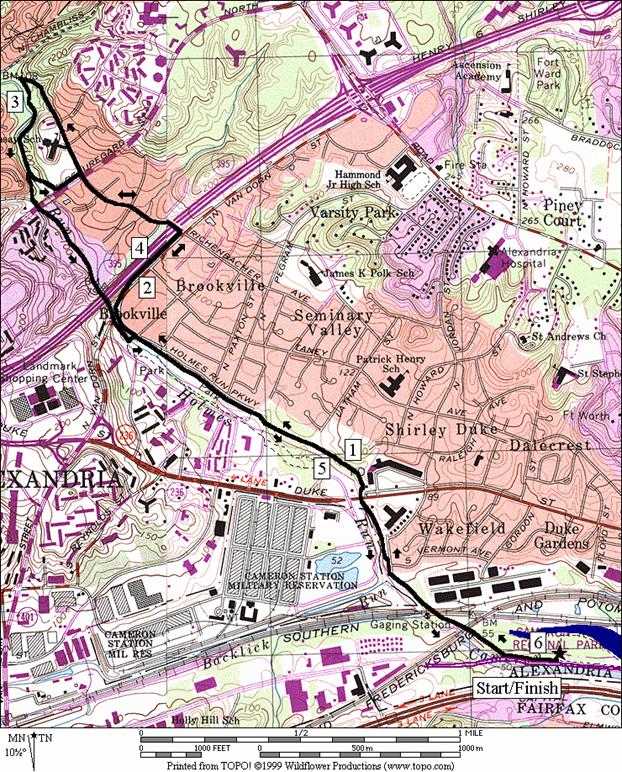
Lower Holmes Run (3.6 or 4.1 miles, III)
The Holmes Run trail starts near Cameron
Run Regional Park. After crossing over and under bridges for
Holmes Run, for the metro and for some railroad lines, the flat paved trail
very slowly climbs. 1.1 miles after
turning to go up Holmes Run, on your right you can see the Bicentennial Witness
Tree; an over 270 year old Willow Oak sitting on top of a small hill. Further ahead, pass the footbridge on the
left to James Marx
All Veterans Park. The bridge is used on the return route. Ahead, after passing through the long field,
there is an option to turn. Going
straight is the AUrban
Route@
of the Holmes Run Trail. Turn left
instead to cross Holmes Run on a concrete wash bridge; this is the AScenic Route.@
You may get a little wet if it has rained recently. Were you to continue the Holmes Run Trail
(see Upper Holmes Run) you would turn right immediately after crossing, going
through the tunnels under I-395.
Instead, after crossing the creek, go up the stairs straight ahead and
bear left to return. A short paved trail
ends soon however, an informal and grassy trail continues along Holmes
Run. Turn left at the
footbridge for the shorter route or make a loop on a gravel trail
through James Marx
All Veterans Park
first, then cross the footbridge and return down the Holmes Run Trail.
Upper Holmes Run (6.05 or 5.7 miles, VI)
This route starts the same as the Lower Holmes Run
route. At the split for the AScenic@
and AUrban@ routes of the Holmes Run Trail, go
straight on the Urban Route. The Urban Route
first parallels I-395, then crosses under it at Sanger
Ave. Use
the sidewalks. At Beauregard
St., leave the designated Holmes Run Trail and
continue straight. You will climb a
little steeper, passing an elementary school on your left. Continuing straight, the road dead ends but
an unpaved trail continues into the densely wooded Dora
Kelly Nature Park. Stay straight, going downhill and, passing
the side trails, then at the point where you would merge onto the paved but
otherwise unmarked Holmes Run Trail (just before N.
Chambliss St.), make a sharp left turn. The Holmes Run Trail here continues downward,
passing a pond, and some rocky areas.
Portions of the trail are concrete to prevent washouts from floods. The area is often a little sandy and
damp. As you near the creek, an obvious
concrete wash bridge crossing on your right is the unmarked Scenic
Route.
Staying on the left side of the creek lets you use the Urban
Route to get back.
The Urban Route
leaves the creek at Beauregard St.
where you can return the way you came.
The Scenic route joins the roads briefly to cross Beauregard
St., then again disappears into the thick
woods. A big dip in the trail drops you
to the creek level and straight into a long corrugated pipe tunnel. There are two consecutive tunnels, for each
direction of I-395 traffic. Both are
long, dark and damp but the second may have as much as an inch deep of
unavoidable flowing water in it.
Amazingly, I did see some in-line skaters struggling to get
through. Had they known what they were
in for they would probably have chosen the Urban Route. Emerging into the daylight, turn left across
the concrete wash bridge to merge with the Urban Route
and then return on the paved trail to Cameron Run.
Portions of the upper Holmes Run Trail from N.
Chambliss St. through the tunnels under I-395 are
isolated, despite the otherwise urban surroundings. Safety was on my mind. However, once when I got a flat tire when on
my bike along Beauregard St.,
one person was kind enough to ask if I needed assistance. Stick to the lower portion of the trail if
you=re nervous about such places.
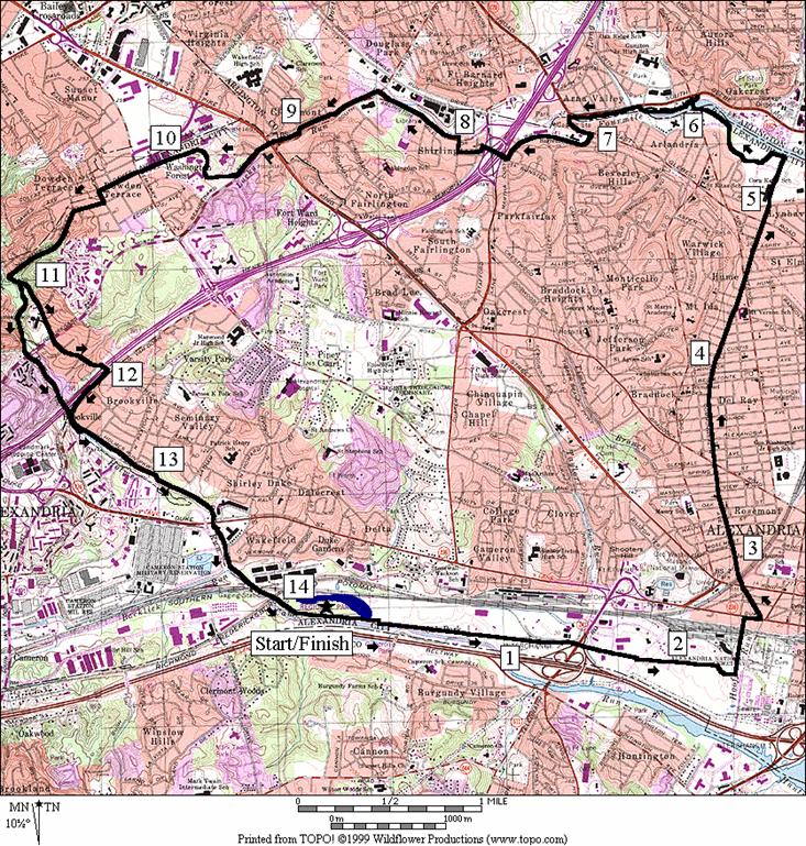
The Big A (14.05 or 14.35 miles, X)
Alexandria, the
big A, is bigger and older than most of the rest of the cities around Washington,
D.C.
Given its size, it has relatively few paved trails when compared to
other area municipalities. Those that it
does have are in more urban settings or on roads altogether. This grand tour uses the main trails, except
for the Mt. Vernon Trail, to touch on most of the areas of the city. There are plenty of other more scenic long routes
in this guide but if you=re
in shape and it is near to you, you might find it
enjoyable. It is suitable for running or
bicycling.
Start by going east along Eisenhower
Rd. and down along Cameron Run. The flat sunny trail along Cameron Run is hot
in the summer and broken-up only by the overpass of Telegraph Rd. Use sidewalks from this point. Construction in the area is likely to change
the route some but look for and turn left on Holland
Lane, passing the African American Heritage Park
on your right as you do. Sculptures,
benches, and its setting near the city=s
old cemeteries make the African American Heritage Park a place for
reflection. Use the city=s traditional red brick sidewalks to
pass through Old Town Alexandria. At the
King Street Metro Station, you can see more clearly the towering George
Washington Masonic National Memorial in the background. The next few miles are on the sidewalks of Commonwealth
Ave. The
basically flat road is lined with old houses; some remodeled, and some
not. It is a designated bike route and
also the site the Alexandria Turkey Trot, held annually in November. At the end of Commonwealth
Ave., turn left on the Wayne F. Anderson
Trail. This trail skirts upstream along
Four Mile Run. A nature preserve is on
the right before you cross Four Mile Run at Mt. Vernon
Ave. and join the Four Mile Run Trail in Arlington. To get over I-395, the route and trail turns
left on sidewalks into Alexandria
again and crosses on a footbridge into Shirlington. At Walter Reed Dr.
leave the Four Mile Run Trail and begin to climb on an unnamed paved
trail. Just before crossing King St.,
you may see the white stone marker on your right, on the Arlington/Alexandria
border that was once part of the original survey of the District
of Columbia that George Washington worked on. The paved trail runs, and you must continue,
on street sidewalks up Walter Reed Dr. Turn right to follow the bike route through
the Alexandria Campus of the Northern
Virginia Community College. The hill or hell (take your choice) is
toughest here. Afterward, follow the
bike route signs through neighborhoods to the Holmes Run Trail head. On the paved trail, descend quickly through
the woods to N. Chambliss St. See the descriptions above for the Upper and
Lower Holmes Run Trails to return.
Nearby and Connecting Zones
Belle Haven
Park and Marina
Thomas Jefferson
Community Center
Bluemont Junction
Daingerfield Island
What to do Afterward
Food and Drink
Generous
Georges Positive Pizza & Pasta Place
- original store of a longtime area pizza and pasta
favorite - 703 370-4303
Chin=s
Kitchen - flavorful carry out Chinese food - 703 765-4600
Copeland=s
of New Orleans - 703 671-7997
Entertainment and Edification
George Washington Masonic National Memorial - (703) 683‑2007
Fort Ward
Museum - (703) 838‑4848
Green Spring Gardens Park - ask about the Manor House
Gardening & Teas Program
-
(703) 642‑5173
Clark House - 703 938 - 8835
African American
Heritage Park
- off Duke Street near Old
Town Alexandria
Lower Holmes Run
Distance: 3.6 or 4.1 miles
Rating: III; mostly sunny; paved and dirt stream
valley trails
3.6
Mile Route
R 0.0 on
the trail from the parking lot
BR 0.2 Holmes
Run Trail crosses the bridge over the creek
0.6 gate;
sign over trail says Tarleton
Park
0.9 underpass Duke St
1.1 Bicentennial
Oak on R
1.25 bridge to James Marx
All Veterans Park
on L
L 1.75 Scenic
Route Holmes Run Trail crosses the creek on a concrete wash bridge
S 1.8 S
up the stairs after crossing the creek and follow the trail as it bears L
BL 1.9 onto
dirt/grass trail after N Ripley St
on R
<*
L 2.35 concrete
bridge over creek
>*
R 2.4 Holmes
Run Trail at T
2.5 Bicentennial
Oak on L
2.7 underpass Duke St
3.0 gate;
sign over trail for Tarleton
Park
BL 3.4 Eisenhower Ave
L 3.6 Cameron
Run Regional Park

*4.1
Mile Route
S 2.35 concrete
bridge on L; go into James Marx
All Veterans Park
UR 2.6 gravel
road merges
R 2.8 N Pickett St
2.85 concrete
bridge over creek (pickup cues at mile 2.4 on 3.6 mile route)
Upper Holmes Run
Distance: 6.05 or 5.7 miles
Rating: VI; paved and dirt stream valley
trails; mostly sunny
6.05
Mile Route
R 0.0 on
the trail from the parking lot
BR 0.2 Holmes
Run Trail crosses the bridge
0.6 gate;
sign over trail for Tarleton
Park
0.9 underpass Duke St
1.1 Bicentennial
Oak on R
1.25 bridge to James Marx
All Veterans Park
on L
S 1.75 Urban
Route Holmes Run Trail; L crosses the creek on a concrete wash bridge
CR 1.9 Van
Dorn St (!); use gravel sidewalk
L 2.2 Sanger Rd
2.55 Beauregard St
2.75 Dora
Kelly Nature Trail at the end of Sanger Rd
L 2.95 Holmes
Run Trail (sharp L)
<*
BL 3.3 to Urban
Route of Holmes Run Trail (unmarked); R crosses
creek on concrete wash bridge
L 3.4 Beauregard St
R 3.5 Sanger Rd
R 3.85 Van Dorn St
L 4.15 to
trail along Holmes Run Pkwy (!)
4.3 Scenic Route
joins from R
>*
4.8 bridge
to James Marx
All Veterans Park
on R
4.95 Bicentennial
Oak on L
5.15 underpass Duke St
5.4 gate;
sign over trail for Tarleton
Park
BL 5.85 Eisenhower Ave
L 6.05 Cameron
Run Regional Park

*5.7
Mile Route
BR 3.3 to Scenic
Route of Holmes Run Trail (unmarked); R crosses
creek on concrete wash bridge; L is Urban Route
L 3.35 N.
Morgan St to stay on trail
BL 3.4 onto
trail after crossing Beauregard St
3.75 begin
tunnel (!)
3.8 end
tunnel/begin tunnel (! wet)
3.85 end
tunnel
L/R 3.95 L at
T to stay on trail; cross creek on concrete wash bridge; R onto Holmes Run
Trail; join Urban Route
(pickup cues at mile 4.8 on 6.05 mile route)
The Big A
Distance: 14.2 or 14.05 miles
Rating: X; paved stream valley trails and
city sidewalks
14.2 Mile Route
L 0.0 on the trail from the parking lot
XS 0.25 at xwalk; Lake Cook on L
1.3 begin Telegraph Rd overpass
BR 2.2 after Hoof=s Run Dr to stay on trail
CL 2.3 Holland La (red brick sidewalk)
R 2.6 Duke St
L 2.7 Daingerfield Rd; becomes Commonwealth Ave at King Street
XS 2.85 at King St, Rte 7 (metro station)
3.55 E Braddock Rd
4.45 Mt Vernon Rec
Center (water)
4.6 Mt Vernon Ave
4.95 W Glebe Rd
XS 5.05 at Walter Reed Ave; Cora Kelly Rec Center
L 5.3 Wayne F Anderson
Trail at T
R 6.0 Mt Vernon Ave; cross creek
R 6.05 to Four Mile Run Trail
R 6.1 Four Mile Run Trail (triangle X)
CL 6.85 W Glebe
Rd
R 7.0 Valley
Dr
BR 7.15 Martha
Custis Dr
R 7.6 Gunston Rd;
footbridge over I-395
R 7.8 28th
St (stores,
food, drinks)
R 7.95 Randolph
St
CL 8.0 Arl Mill Dr; onto the Four Mile Run Trail
CL 8.5 Walter
Reed Dr
8.55 Four Mile Run Tr
small stone bridge on R
9.2 King St (Rte 7)
R/L 9.5 W Braddock Rd/E Campus Dr (hill); follow
sidewalk; cut the corner at the top
L 9.85 Dawes
Ave
10.2 Seminary
Rd
L 10.4 N
Stevens St
CR 10.5 Fillmore Ave; becomes Chambliss St
10.85 Holmes Run Trail head; end of road
11.1 onto N Chambliss St at end of trail
L 11.2 trail head at Dora Kelly Nature Park
<*
BL 11.25 Dora Kelly Nature Trail
11.45 S on Sanger Rd at trail end
R 12.0 Van Dorn St
L 12.3 to trail along Holmes Run Pkwy (!)
12.45 Scenic
Route joins
from R
>*
12.95 bridge to James Marx All Veterans Park
13.3 underpass Duke St
BL 14.0 Eisenhower Ave
L 14.2 Cameron Run Regional Park
*14.05 Mile Route
BR 11.25 to stay on trail as Nature Trail goes up on L
BR 11.6 Scenic Route crosses creek on concrete wash
bridge(unmarked); L is Urban Route
L 11.7 N. Morgan St to stay on trail
BL 11.75 onto trail after crossing Beauregard St
12.05 begin tunnels (! wet)
L/R 12.3 cross creek on concrete wash bridge; (pick-up
cues at mile 12.95 on 14.2 mile route)
The
Big A