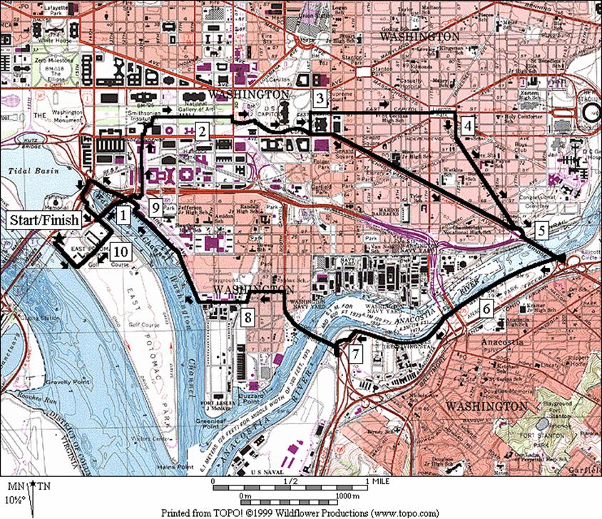
East Potomac Park & The Mall
One
of L=Enfant=s many enduring marks is designing the
layout of the city and the Mall. Parisian
in concept, built on a filled-in swamp, mostly open and wide, the Mall is cared
for by the National Park Service. Packed
with museums, monuments, and memorials, it is mostly a placid place where lunch
hour bureaucrats (like me) dance for Americans who have come from the heartland
to contemplate the greatness of the country.
The country=s leaders
are seen here on the streets or in siren lead motorcades. It=s
a place where science, art and humanity are held in high esteem, and a place
where historic and modern battles for freedom are waged. Tanks once chased Bonus Marchers (protesting
veterans of WWI) away from here in 1932.
The British burned the White House, set fire to the Capitol, the
Treasury and several other buildings during the War of 1812. Martin Luther King Jr. spoke from the steps
of the Lincoln Memorial in 1963 to a tumultuous country of his dreams of
non-violence and freedom before his life was ended early by a shot. Pro-Choice and Pro-Life protestors line-up to
be counted from the air. Farmers parked
their tractors here when policies were unfavorable. Harrier Jets dropped from the sky as Gulf-War
veterans were celebrated and welcomed back here. The Beach Boys played a concert on the
Fourth-of-July one year but were said to attract the wrong element, and left
out the next. A Million-Men marched here
in brotherhood and discussed personal responsibility. Celebrations such as A Taste of D.C., The
Folk Life Festival, The Cherry Blossom Festival, and of course the biggest
party of all, the Fourth of July, are regular events.
Getting
There
From
Montgomery County, MD
Exit
the Capital Beltway (I-95), onto Connecticut Avenue
south.
Follow it 7.6 miles to K Street,
then bear right as it becomes 17th Street. After crossing the Mall one mile later, bear
right onto the one-way portion on Independence Avenue. Turn left at the traffic light 0.6 miles
ahead onto Ohio Drive,
which goes along the shore of the Potomac. After crossing the bridge over an outlet of
the Tidal Basin,
turn right to stay on Ohio Drive. Park at the third lot on the left, after the
metro rail overpass and before the railroad overpass bridge going over the Potomac.
From
Northern Fairfax County, VA
Exit
the Capital Beltway onto the George Washington Parkway. Go southbound for 10.4 miles to the 14th
Street Bridge (I-395), then go northbound into Washington
D.C.
Stay to the left while crossing the bridge to stay on 14th
Street (see the sign for Route 1). Turn left on Jefferson
Drive, just after the Independence
Avenue intersection (there=s
no left turn onto Independence Avenue
from 14th Street). Turn left again one-block later at the T
intersection with 15th Street,
in front of the Washington Monument. Bear left at Main
Avenue, and then turn right immediately on the
ramps toward I-395 south, and the Jefferson Memorial. Stay to the right, passing the Jefferson
Memorial on the right as the bridge traffic merge lanes on the left. Bear left, onto Ohio
Drive, at the small bridge on the right. Park at the third lot on the left, after the
metro rail overpass and before the railroad overpass bridge going over the Potomac.
From
Southern Fairfax County, VA
Exit
the Capitol Beltway, I-95, northbound onto Henry G.
Shirley Highway (I-395). After approximately 9.5 miles, cross the 14th
Street Bridge,
staying to the left where the road splits.
This puts you on 14th Street
and Route 1. Follow the instructions
above (from 14th Street)
for northern Fairfax County.
From
Prince Georges
County, MD
Use
the Capital Beltway (I-95), to get to Rte. 50 west or I‑295 north. From either, take the westbound Southeast
Freeway (I-395) after 11 miles or approximately 6 miles respectively. After 0.9 or 2.75 on the Southeast Freeway
respectively, bear right onto Main Avenue. Main Avenue
merges onto Independence Avenue
at the Tidal Basin. Follow the directions above (from Independence
Avenue) for Montgomery
County.
By
Metro Rail
Ride
metro rail=s Blue or
Orange lines to the Smithsonian
station, using the Mall exit. Start from
there on one of the routes that passes by or turn right at the top of the
escalator to Jefferson Drive. Turn right along Jefferson
Drive toward the Washington
Monument. Turn left on 15th
Street, then follow the directions above (from 15th
Street) for northern Fairfax
County.
Area
Routes
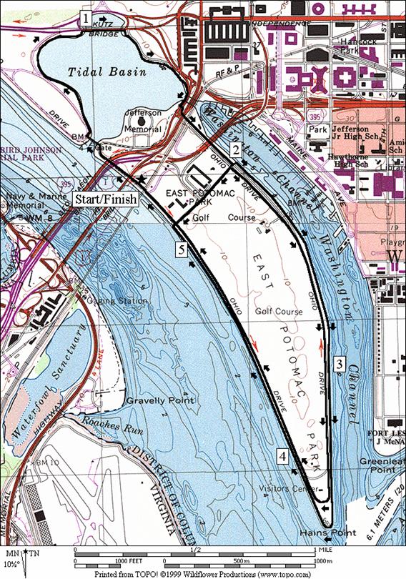
Tidal
Basin and Haines
Point (5.3, 5.05, or 2.55 miles; IV, III or II)
This
classic route has made-up the core of many of the areas most famed road
races. The annual Marine Corps Marathon
and the Cherry Blossom races both use variations of the same route. Starting along Ohio
Drive South, head northwest along the Potomac. The fountain in the garden to the right of
the crosswalk before the Tidal Basin=s Inlet
Bridge, was erected at the direction
of First Lady Helen Taft. After crossing
the bridge, turn right to the very edge of the Tidal
Basin and go around it
clockwise. You will pass under (you may
have to duck occasionally depending upon how tall you are) the famed Cherry
trees, a gift from Japan. Don=t
expect to be able to run here during the blooms (no bicycling at anytime). The rail-less sidewalk is packed with people
when the blooms are out. Blooms usually
occur in late March or early April but don=t
always coincide with the timing of the Cherry Blossom Festival and parade
(April). As you go around the basin, the
newest major memorial, to President Franklin D. Roosevelt, is on the left. Use the narrow sidewalk on the Kutz
Bridge to cross over a portion of
the Tidal Basin,
then continue around past the boat rental and parking areas. As you approach the Jefferson Memorial, you
will find the left turn along Ohio Drive North
which takes you out to Haines Point. A
complete loop around only the Tidal Basin
is 1.81 miles.
Haines
Point is a flat peninsula in-between Washington Channel and the Potomac
River. Nearly every Washington
area runner who has raced here has felt at one-time or another a certain misery
with the long straight and often windy stretches. They usually happen to coincide with the
latter half of races. The scenery is
splendid, but the long straightaways can make you feel like you=re running on a treadmill. You have options to take the road as the
races do (during 5/29B9/6
the road is closed to traffic 3PMB6AM) or use the
sidewalk The sidewalk is along the
shoreline and has the best views however, it is in need of repair. Watch-out for storm damaged tilted concrete
blocks and occasional debris from the river if you use it. Both the road and sidewalk circumnavigate a
public golf course. For those taking the
road, a reward at the turnaround is the sight of the famous Awakening
sculpture. It features a gargantuan
image of a man in a pained expression (hopefully not reflecting your own
physical state upon arriving) perhaps struggling as he emerges from the
ground. Children climb all over it and
even stand in the mouth. Those taking
the sidewalk go further and reach the last bit of land at the point. From there you can see the mouths of the
Washington Channel and the Anacostia river, a view of the Potomac
down to the Wilson Bridge,
and a view of National Airport=s jets landing and taking-off. Complete loops only around the Hains Point
using Buckey Drive are 3.46
and 3.19 miles for the sidewalk and road respectively.
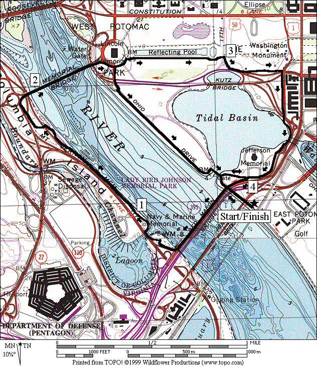
Memorial Tour (4.45, 4.75 or 3.5 miles, III, III
or II)
Four
majors bridges cross the Potomac River into downtown Washington. Use two of the largest on this route to pass
near many of the memorials and monuments that define Washington=s outward image. From Ohio Drive
South, take the stairs up to the 14th
Street Bridge.
Optionally go around along the road and past the garden and fountain
that Helen Taft=s
instituted, to use a ramped trail up to the outbound 14th
Street bridge (George
Mason Bridge). On the bridge the views are great. The trail is wide enough for two bicycles
coming in opposite directions to pass safely.
See the waters below, Franklin
Delano Roosevelt
Memorial Park, Arlington
Memorial Bridge,
Rosslyn, and the Virginia shore. After crossing the river, use the
Mt. Vernon Trail to pass through Lady
Bird Johnson Park
(technically part of D.C.). Carefully
cross the George Washington Parkway
and an exit ramp to get onto Arlington
Memorial Bridge. The wide walkway on Memorial bridge leads to
a traffic circle around the Lincoln Memorial.
The short route returns from here along Ohio
Drive South through Franklin
D. Roosevelt Park,
and past the great President=s
memorial. The longer route passes along
the east side of the Reflecting Pool, and near the Korean War Veterans
Memorial. A memorial to veterans of
World War II may be built at the end of the Reflecting Pool, near 17th
Street.
Cross 17th Street
and turn right. The sidewalk/trail will
bear left to parallel Independence Avenue
at the Tidal Basin. The Washington
Monument will be on your left. Turn right at 15th
Street to reach the Tidal
Basin and go past the Jefferson
Memorial on the return through West Potomac
Park to East
Potomac Park.
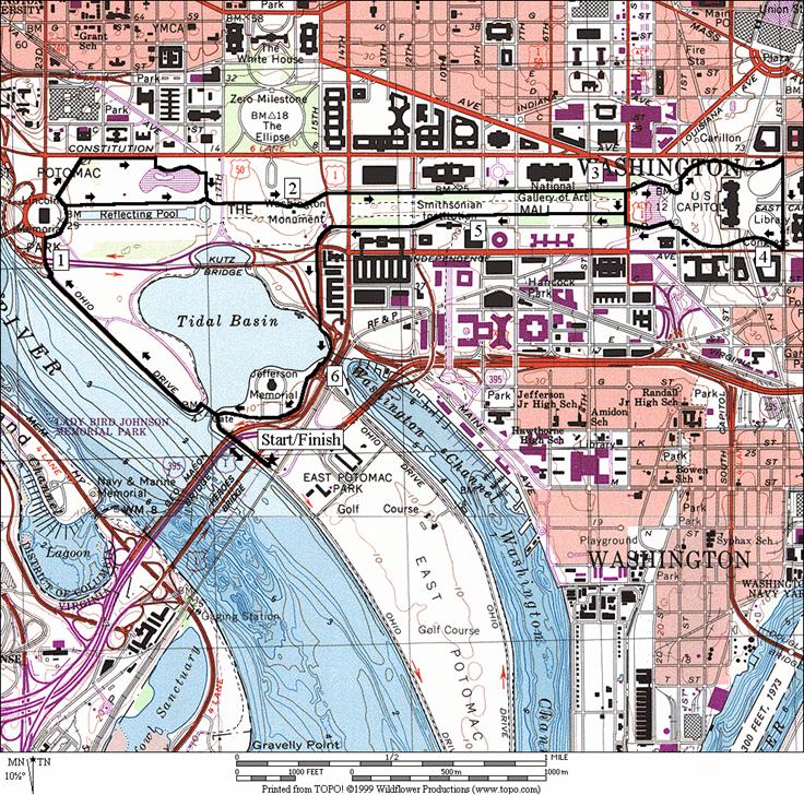
The Mall & Capitol Hill (6.7, 6.95, or 5.3
miles, VI, VI, or IV)
Go
northwest along the shores of the Potomac River, past
the Franklin D. Roosevelt Memorial to the Lincoln Memorial. Round the circle and head straight up along
the Reflecting Pool. The path along the
Reflecting Pool is soft and shaded under rows of trees. As an option, from the Lincoln Memorial take Henry
Bacon Dr. to Constitution
Avenue past the Vietnam Memorials. Continue from there in sight of the Einstein
Memorial (across Constitution Avenue),
and through Constitution Gardens
(a Bicentennial addition) to the Reflecting Pool to join the regular
route. As an art piece, the Einstein
Memorial is one of my favorite memorials.
A larger than life bronze sculpture of Einstein depicts him sitting
comfortably on the edge of a circular map of the Universe made into the floor
below him. Stand in the center of the
circle and say Athank you
for Relativity@ to him
for a surprise. From the path along the
Reflecting Pool, cross 17th Street,
and go toward the base of the Washington
Monument. About 50 yards before getting there, look for
a small stone marker on the right. It
signifies the location of Jefferson Pier, which stood here between 1804 and
1889. Also see a good view of the White
House from here. After passing the
monument and crossing 15th and 14th Streets, you=ll pass several of the older
Smithsonian museums; American History, Natural History, and the East and West
wings of the Natural Gallery of Art. The
19th century philanthropy that got the Smithsonian Institution
started came from the newly acquired riches of James Smithson. A story has it that he was shunned by British
society peers that he wished to socialize with, so he somewhat spitefully
resolved to make his name outlast theirs through history. He accomplished his objective elegantly and
beneficently through the museums bearing his name. They educate and stimulate people from all over
the world. Just before the 7th
Street crossing, are the National
Sculpture Garden,
installed in 1999, and an ice rink. Turn
back at 7th Street
to the other side of the Mall for a shorter route or continue on to loop around
Capitol Hill.
As
you approach the Capitol building, keep the pool on your right by following a
dirt path. At the circle at 1st
Street NW (Union Square),
go clockwise three-quarters of the way around.
Turn right off it up a road onto the Capitol grounds. A ADo
Not Enter@ sign
posted there is for cars. Climb (about
70 feet vertical) the curving road and at the top bear left at a triangular
intersection. It leads to 1st
Street NE at Constitution
Avenue.
Turn right on 1st Street,
passing the Supreme Court and the Library of Congress on your left. Just before hitting Independence
Avenue, turn right into the Capitol building
grounds again, past another ADo
Not Enter@ sign for
cars. Go back down the hill to a second
circle at Union Square. Going clockwise again around the circle, pass
the Botanic Garden, and the future site of the National
Museum of the American Indian. Other sights as you continue back down the
Mall are: the National Air
& Space Museum,
the Hirshorn Museum
and Sculpture garden, the Centennial Museum,
the Smithsonian Institution
Building (affectionately known as
The Castle), the Freer Gallery of Art, and the Department of Agriculture. As you approach the Washington
Monument again, turn left on 15th
Street following it past the Holocaust
Memorial Museum
and the Bureau of Engraving and Printing to the Tidal
Basin. Round the Basin past the Jefferson
Memorial to East Potomac
Park.
Southeast Tour (10.45 or 10 miles, IX, VIII)
No
tour of Southeast Washington would be complete without
some time spent along the water. This
route does that and more. Expect for Capitol
Hill, the only hills are those of the bridges.
Leaving Ohio Drive,
the route takes a different way to the Mall than other routes listed here. By doing so it avoids several traffic
intersections. Pass over a portion of
Haines Point, then use the trail on the Francis
Case Memorial Bridge
(I-395) to get to Banneker Circle
and L=Enfant
Plaza. Pass under the Department of Energy complex
and into the formal Enid Haupt gardens in front of the Smithsonian
Castle. On the sides of the garden are the Centennial
Museum, the National Museum of
African Art, and the Sackler and Freer galleries. Exiting the garden around the right end of
the Smithsonian Institution
Building (The Castle), hit The Mall
at the carousel and turn right toward Capitol Hill. Most Washingtonians born and raised here like
me (and many who were not) have ridden this carousel as kids. Pass the Hirshorn Sculpture gardens, the Air
& Space Museum,
the future site of the National Museum
of the American Indian, the Botanic Garden, and the Capitol
Building.
Once
past the Capitol, you=re
in Southeast D.C.
Turn left to get to East Capitol Street,
then pass the Library of Congress, the Supreme Court, and the Folger
Shakespeare Library. East
Capitol Street is reminiscent of streets found in Georgetown
and Old Town Alexandria. Young
professionals, Congressional Representatives, many other long-time D.C.
residents live there. As Washington
area traffic has gotten worse, many have found that living here is convenient
and animated. Being street savvy here is
important however, as the character of the surrounding areas changes
quickly. Cut through Lincoln
Park, a grassy square, then turn right up 13th
Street.
Turning left on Kentucky Avenue,
the neighborhood gets quieter and you emerge at Barney
Circle. If
you prefer staying on the beaten path, you can skip all the above, and come
straight from the Capitol grounds, down Pennsylvania
Avenue to Barney Circle. You=ll
pass Eastern Market, a weekly produce and artisan vending place, as well as
some of the local night spots where conversation in the bars and dinning spots
is more likely to cover foreign and domestic policy rather than the weather or
the movies.
From
Barney Circle, the John
Phillip Sousa Bridge
takes you over the Anacostia River
into Anacostia Park. A sidewalk is available part of the way
through the park but unless you use the grass, it is necessary to use the road
a little. The road parallels the river. Traffic is usually light but on a warm spring
days when those with cabin fever come out, it can be busier. Across the river you can see the Washington
Navy Yard, the oldest continually operating federal facility in the nation
according the Washington Post. The guns
of the USS Missouri were made here and the USS Barry can be seen moored. Cross back over the Anacostia
River on the Frederick
Douglas Memorial
Bridge. The path on the bridge is narrow but is
protected and offers nice views.
Cut-over to the Washington Channel by passing Fort Lesley McNair (circa
1791), site of the Naval War
College on your left. As you reach the channel, observe the angelic
statue on the left, a memorial to the Titanic (It is reminiscent of a famous
seen from the more recent hit movie). The
ship sunk in 1912 and the memorial was erected in 1931. A walkway along the channel lets you see
Haines Point, waterfront restaurants and many ships and boats. Pass the Fish and Seafood Market and turn
left before reaching the Tidal Basin. Turn left again using Ohio
Drive and Buckeye Drive
to return to the parking.
Nearby
and Connecting Zones
Food
and Drink
Bull
Feathers - (202) 543‑5005
Bread
& Chocolate - (202) 547‑2875
Hogate's
Seafood Restaurant - (202) 484‑6300
Phillips
Flagship Restaurant - (202) 488‑8515
Old
Post Office Eatery - 202 606-8691
Entertainment
and Edification
Odyssey
Tours - dinner and lunch cruises on
the Potomac - (202) 488-6000
Folger
Shakespear Library - (202) 544-7077; www.folger.edu
Arena
Stage - theater performances - (202) 543‑5005
F.D.
Roosevelt Memorial - W. Potomac Park
Jefferson
Memorial - (202) 426‑6822
The
Washington Monument
- (202) 426‑6839
Smithsonian
Museums - (202) 357‑1300
The
White House - 202 755-7798
and
many, many more national institutions.
Tidal Basin and
Haines Point
Distance: 5.3, 5.05, or 2.55 miles
Rating: IV, III or II; concrete sidewalks
at water=s edge
and paved roads
5.3
Mile Route
R 0.0 Ohio
Dr S from the parking lot
0.2 stairs
on R to 14th St
Bridge
L 0.25 at
Rd X & xwalk to stay on Ohio Dr;
over Inlet Bridge
R/L 0.3 trail
X on R after bridge & clockwise on trail around the Tidal
Basin
0.45 F.D.
Roosevelt Memorial on L (no bikes)
0.8 trail
X on L to Lincoln Memorial
R 1.0 Independence Ave;
Kutz Bridge
over the Tidal Basin
BR 1.15 after
Kutz Bridge
to continue loop around the Tidal Basin
1.4 docks/boat
rentals
1.5 15th
Street on L
1.55 water,
then begin Outlet Bridge
XS 1.65 crosswalk
on L
BL 1.7 Ohio
Drive North (underpasses I‑395)
1.85 trail
X on R to Banneker Circle
<*,
<**
L/R 2.0 across
grass at Buckeye Drive to
sidewalk along Washington Channel
3.55 Awakening
Sculpture on R
3.65 Hains
Point
R/L 5.1 across
grass to Ohio Drive S at Buckey
Drive
>*,
>**
R 5.3 into
parking

*5.05
Mile Route
2.0 Buckeye Drive on
R
2.3 golf
course entrance on R; phone
2.4 water
3.3 trail
X on R
3.5 Awakening
sculpture on L
3.75 trail
X on R
4.0 restroom/water
4.65 restroom/water
4.85 Buckey
Drive on R (pickup cues at mile 5.3 on 5.3 mile route)

**2.55
Mile Route
R 2.0 Buckeye Drive
R 2.3 Ohio
Drive South (pickup cues at mile 5.3 on 5.3 mile route)
Tidal Basin & Hains Point
Memorial Tour
Distance: 4.45, 4.75 or 3.5 miles
Rating: III, III or II; paved and crushed gravel
trails, sidewalks; fairly flat
4.45
Mile Route
R 0.0 Ohio
Dr S from the parking lot
<*
R 0.2 stairs
on R to 14th St
Bridge
UR 0.2 14th Street
Bridge; Potomac River
>*
L 0.75 at
T; Mt Vernon Trail (unmarked)
1.0 parking
for LB Johnson Park
on L
L 1.65 trail
X on L to Memorial Bridge
(unmarked) crosses the GW Pkwy (!)
1.75 trail
X on L to the Pentagon
1.8 cross
exit ramp (!)
1.85 trail
X on L to Arl Mem
Cemetery; go S onto Memorial
Bridge
2.3 circle
at Lincoln Memorial; follow walkway counter-clockwise around
<**
2.4 Ohio Dr South on
R
R 2.5 first
ramp/stairs down to the Reflecting Pool; pool is to L
CR 3.0 17th Street;
follow trail as it bears L and then parallels Independence
Ave at the Tidal
Basin
R 3.35 15th Street
CL 3.6 Main
Ave; follow trail clockwise around the Tidal
Basin; (water)
3.75 trail
X on L to Ohio Dr North
4.0 trail
X on L to 14th Street
Bridge; restroom under Jeff Memorial on R
BL 4.2 Ohio Dr South; Inlet
Bridge on R
>**
4.25 stairs
on L to 14th Street
Bridge
L 4.45 parking
after metro bridge
*4.75
Mile Route
0.2 stairs
on R to 14th St
Bridge
BR 0.25 at Inlet
Bridge on L; leave Ohio
Dr S
R 0.4 trail
X on R at crosswalk; to 14th Street
Bridge
0.5 begin
14th Street
Bridge; stairs on R (pickup cues at mile 0.2 on 4.45 mile route)

**3.5
Mile Route
CR 2.4 Ohio Dr South
XS 2.5 at
crosswalk after crossing Independence Ave
BL 2.55 join
trail at circle w/river on R and Ohio Dr South
on L
2.8 FDR
Memorial and parking on L (water at mile 2.85 and 3.05)
BR 3.2 to
follow Ohio Dr S over Inlet
Br
CR 3.25 at
Rd X after Inlet Bridge
to stay on Ohio Dr S
(pickup cues at mile 4.25 on 4.45 mile route)
The Mall &
Capitol Hill
Distance: 6.7, 6.95, or 5.3 miles
Rating: VI, VI, or IV; paved and crushed
gravel trails through city parks
6.7 Mile Route
R 0.0 Ohio Dr S from the parking lot
L 0.25 at Rd X to stay on Ohio Dr S; over Inlet Bridge
BL 0.3 follow trail on L after bridge; trail X on
R is to Tidal Basin (water at miles 0.5, 0.7)
XS 0.95 at crosswalk before circle
1.0 Independence
Avenue
R 1.1 circle at the Lincoln Memorial
<*
R 1.25 second ramp/stairs on R to Reflecting Pool
1.7 trail X on L to Constitution Gardens
>*
BL 2.0 Washington Monument; BL through circle
& BL again to 15th
Street at Madison Dr
S 2.1 15th St; walkway/path along Madison Dr
<**
3.1 3rd Street; dirt trail toward pool
BR 3.25 clockwise around circle at 1st Street; go around 3/4 then R on road into Capitol grounds; (ADo Not Enter@ sign is
for cars)
BL 3.55 triangle X at top of hill; Capitol on R
R 3.7 1st
Street NE
3.85 East Capitol St on L
R 3.95 road into Capitol grounds; (ADo Not Enter@ sign is
for cars)
BL 4.05 triangle X; then down Capitol Hill
CL 4.3 clockwise at circle at 1st St and CL at Maryland Ave
BR 4.45 dirt trail to 3rd St
R/L 4.55 R after crossing 3rd St; L on gravel path
>**
5.05 after Carousel
BL 5.2 after the Castle; to follow path along Jefferson Dr
5.25 Smithsonian Metro station on R
CL 5.5 15th
St
5.6 Independence
Ave
CL 5.85 clockwise around Tidal Basin; water
BL 6.45 Ohio Dr
S; Inlet Bridge on R
L 6.7 parking after metro bridge

*6.95 Mile Route
R 1.3 Henry
Bacon Dr
R 1.45 Constitution
Ave
R/L 1.7 19th
St on L; R
to the pond; L at the pond
L/R 1.85 L to stone patio away from pond; R on patio
L 1.95 at T at the Reflecting Pool (pickup cues at
mile 2.0 on 6.7 mile route)
**5.3 Mile Route
R 3.1 3rd
Street
R 3.15 second gravel path in the open on The Mall
(pickup cues at mile 5.05 on 6.7 mile route)
The Mall and Capitol Hill
Southeast Tour
Distance: 10.45 or 10.0 miles
Rating: IX or VIII; crushed gravel on the
mall, sidewalks, asphalt paths and roads; sunny
10.45 Mile Route
L 0.0 Ohio Dr S from the parking lot
CL 0.2 Buckeye
Dr
L 0.55 Ohio Dr
N
L 0.65 trail X on L toward bridge
UR 0.7 at Francis Case Bridge (I-395)
L 1.15 Banneker Cir; L=Enfant
Promenade
S 1.55 cross Independence Ave; go through Enid Haupt Garden exiting R of the Castle past Jefferson Dr onto The Mall
R 1.7 The Mall; R at the carousel toward the
Capitol
R/L 2.2 3rd
St SW; onto
dirt trail toward pool
BL 2.3 Maryland
Ave SW
R 2.4 at 1st St SW circle go counter-clockwise and turn R into Capitol
grounds up hill
BR 2.65 at triangle X at top of hill
<*
L 2.8 1st
St SE
R 2.95 East
Capitol Street
S 3.7 cross 11th St SE into Lincoln Park
R 3.9 at T; 13th St SE
L 4.05 Kentucky
Ave SE
CL 4.75 Barney
Circle on to
trail (Bike
Route)
>*
BR 4.85 trail X; go to bridge: Penn Ave SE
L 5.2 trail X (triangle) after bridge
L 5.3 Water
St SE
(unmarked) go under bridge
6.15 underpass 11th Street Bridges
6.35 Good
Hope Rd on L
CL 6.9 Rd X on L before bridge
R/L 7.0 trail X on R to go under bridge
UL 7.15 sharp L onto Frederick Douglas Br
L 7.7 O Street
SE
L 7.95 Water St
SE
CR 8.0 at T onto P Street SE
S 8.2 P St SE ends; use walkway to the waterfront
R 8.3 at T; Washington Channel walkway
R/L 9.05 R at Fish Mrkt; L on sidewalk on Main Ave
L 9.45 after 14th St underpass (unmarked)
BL 9.6 Ohio Dr
North
XS 9.65 at crosswalk
9.8 trail X on R toward bridge
CR 9.9 Buckeye
Dr
R 10.25 Ohio Dr
South
R 10.45 into parking after RR underpass
*10.0 Mile Route
S 2.8 onto Independence Ave
BR 2.95 Pennsylvania
Ave
3.4 7th Street SE (Eastern Market)
3.85 13th Street SE
CL 4.25 Barney
Circle onto
trail (Bike
Route)
R 4.35 trail X (triangle) (pickup cues at mile 4.85
on 10.45 mile route)
Southeast Tour