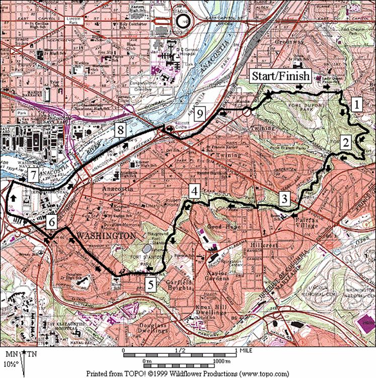
Fort Dupont Park
It=s
unfortunate that few people not already living in Anacostia
in southeast Washington D.C., venture there to explore it. Though basic unfamiliarity and concerns
about crime are voiced, there are nice places to see.
Start
with Fort Dupont
Park. The hilly wooded park has trails, golf, picnic
facilities, and summertime outdoor theater.
The park can give you an idea of what the other hills around the river
looked like before they were developed.
The 1.25 mile long rectangular shaped park is under 50ft. in elevation
near the river and over 300ft. in elevation at the other end near Prince
Georges County. In one large area the mature trees on the
hillside are complemented with one of the most profuse growths of mountain
laurel anywhere near Washington D.C.;
including the Shenandoah National
Park. In
fact, in some parts, you=d
hardly know the difference.
Fort
Dupont was part of the circle of
fortifications built around Washington D.C.
during the Civil War. Several other
circle forts, now parks, are in Anacostia. A greenway and the Fort
Circle hiker-biker trail connect them all. They are maintained by the National Park
Service just as the Rock Creek, Prince
William Forest,
Mananssas Battlefield Fort Washington and Greenbelt
parks are, though it is in a little more disrepair. Exhibits of the history are limited too.
The
Fort Circle trail is
primarily surfaced with cinder and gravel.
It is well suited to running or mountain biking as well as walking. The middle of the trail is located inside Fort
Dupont. Both ends of the trail stop near enough to
the Anacostia
River to allow you to make looping
routes to it. A series of other parks
line the river. Some of these are used
considerably, and some are more solitary.
Getting
There
From
the Capital Beltway (I-295) from either the north or south end to Pennsylvania
Ave. headed east.
At the next stoplight, turn left onto Minnesota
Ave. After
just over half a mile turn right onto, instead of passing through the middle
of, Randle Circle, then leave the circle on Fort
Dupont Dr.
Turn left into the parking area after 0.2 miles.
Area
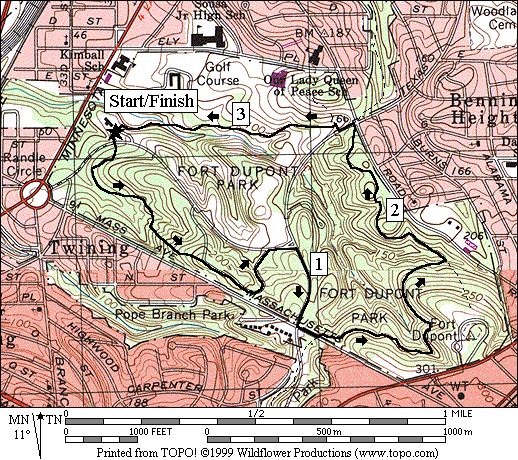
Routes
Dupont
Loop (3.4 miles, IV)
For
an introduction to Fort Dupont
Park, this counter-clockwise loop
climbs a steep nature trail, then returns on easier
paved and unpaved trails. In the
middle, after the climb and on a segment of the Fort
Circle hiker-biker trail inside Fort
Dupont Park,
the route almost follows contour lines bending left and right around small
ridges in the hill, gaining or losing only small amounts in elevation. Running or riding that part is a little like
driving a sport car on a twisty mountain road. The most impressive views of the forest and
the mountain laurel are best in the middle section also. May is an excellent time to go to catch the
blooms but it=s pretty
even in winter.
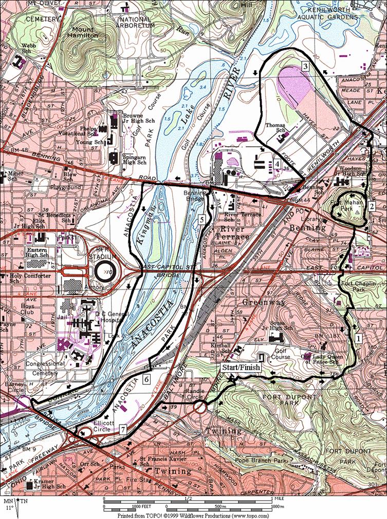
Kenilworth
Park (7.85, 4.4 or 8.25 miles; VII, V or
VII)
Climbing
to the Fort Circle trail in
reverse relative to the Dupont Loop, this route breaks off, leaving Fort
Dupont Park
to go up and down hills on the way north to Fort
Mahan Park. The Fort Circle
trail is not always well maintained in this section but it is easy to
follow. Often ruts carve the trail and
other debris including gumballs, small branches and even glass are not uncommon
on the gravel and cinder trail. Upon
reaching Fort Mahan,
one option is to loop the hill and return as you came.
Continuing
on after Fort Mahan
for longer options, cross under Kenilworth Ave
into the more open and quiet Kenilworth
Park. As you near the river on a broken and
crumbled road, you will pass a few large fields. In one, I saw spring wildflowers cover most
of the ground and large budding willows in the background. In another, a game of rugby was being played
right beside the Anacostia river
and across from the National Arboretum.
Continuing through Kenilworth Park,
the road becomes dirt after passing through a gate which closes it to
cars. It curves back through a desolate
area toward Kenilworth Ave. Go clockwise around the power plant on the
roads and sidewalks until you reach River
Terrace Park. Another option to cross the river through the
Robert F. Kennedy stadium parking lot to Pennsylvania
Avenue is available here. Skipping the option take an old weathered
asphalt trail through River Terrace
Park. The trail is clearly visible from the Orange
and Blue metro lines as they pass above near the power plant. River
Terrace Park
is a good place to watch snowy egrets or great blue heron as they hunt or sleep
on a muddy sandbar in the river. The
trail runs out at Whitney Young
Memorial Bridge
(East Capital St.), but
another dirt road continues on. This one
too passes a desolate section between the river and the Anacostia
Freeway. The tree lined road is obscured
from view of the freeway but is used by those unloading items from the freight
rail stop ahead. I saw the Ringling
Brothers=s Circus
offloading items there. After crossing
the tracks, the surroundings change suddenly again. Anacostia
Park is relatively manicured and used
by many athletic groups. Several
Ultimate (flying disc) games were being played in earnest when I passed
by. Return on Pennsylvania
Ave., and a back-road that is designated a bike
route to Fort Dupont
Park. Apartments and houses are on the road but it
is off the beaten path.
A
note on crime in the area: Travel in groups and with sufficient time to return
before dark. If your
uneasy with going ahead on the route, turn back. Plan ahead and trust your own instincts on
how much exploration you are up to.
There are other good places to go.
This route is mostly on open park land but the Anacostia River
has a reputation almost as bad New York City=s East River. Studies show that crime is lower where there
are eyes on the streets, and this route passes through several isolated
areas.
Fort
Stanton (9.7 miles,
IX)
Climbing
to the Fort Circle trail as
does the Kenilworth Park
route, this route breaks off, leaving Fort
Dupont Park
to go east to Fort Stanton
Park. It has some sections on the Fort Circle trail
that are nicer than those inside Fort Dupont, but it also has some that are
worse. First of all, it=s
hillier. As you leave Fort
Dupont Park,
it winds up and down ridges; not as much around them as the trail did inside Fort
Dupont Park. Some of the beautiful houses bordering the
park along the way look like those found in Tenleytown,
with large sheltering roofs, A-frames, and balconies. Daffodils or blooming trees can be found
lining the way too. Crossing a road
however, the park can change suddenly with trash piled along the trail or even
a homeless person=s
cardboard shelter. In one spot just
before reaching Fort Stanton, an orange rusty puddle, deeper than I thought,
almost made it impossible to get past without getting wet. At the end of the trail, the Anacostia Museum
and Center for African American History and Culture, part of the Smithsonian
Institution, houses first class art as well as cultural exhibits. In spite of my own disheveled appearance from
the trail, and while they gave me a drink of water there, the very friendly
museum employees greeted and chatted with me about Anacostia,
the museum and about the then current exhibit, Locating the Spirit: Religion
and Spirituality in African American Art.
Leaving
the museum, the route heads steeply down the increasingly urban Morris
Rd. on sidewalks.
Pass a hub of activity, colorful shops along Nichols
Ave., and the Anacostia
metro station before crossing under I‑295 on Howard
Rd. The way
back from there is through Anacostia
Park, along the river. Almost immediately upon entering it, you are
likely to get a view of a destroyer ship, such as the U.S.S. Barry, docked in
the Washington Navy Yard across the river.
A sidewalk is available part of the way through the park but unless you
use the grass, it is necessary to use the road a little. The park is sunny and flat up until you turn
out of it at Pennsylvania Ave.,
to go back toward Fort Dupont
Park on the bike route used in the Kenilworth
Park route.
Nearby
and Connecting Zones
U.S.
National Arboretum
College
Park/Riverdale
East
Potomac Park
& The Mall
What
to do Afterward
Food
and Drink
picnic
Entertainment
and Edification
Frederick
Douglas National Historic Site - 202 690-5185/202 426-5960
Smithsonian
Anacostia Museum
and Center for African American History and Culture - 202 287-2060
Kenilworth
Aquatic Gardens
- 202 426-6905
National
Arboretum - 202 -245-2726
Fort
Dupont Summer Theater - 202 426-7723
Dupont Loop
Distance: 3.4 miles
Rating: IV; hilly gravel blazed trails,
some roads and paved hiker-biker trails
0.0 from
the Activity Center,
exit the parking lot, to the trail across Fort Dupont
Dr
L 0.25 trail
X; wooden bridge on R
BR 0.3 trail
X (fork) at Nature 8; cross the wooden bridge and climb (steep)
S 0.6 at
parking
R 0.9 Fort Dupont Dr
CR 0.95 Fort Davis Dr at T
L 1.2 Mass
Ave on shoulder
L 1.25 Fort
Circle Trail head
L 1.8 at
T to stay on Fort Circle Trail; L is to wooden bridge; uphill is on R
L/R 2.7 Fort
Davis Dr; leave Fort Circle Trail to paved trail on other side
L 2.75 trail
X on L
L 3.4 at
T after stage
3.4 parking
and Activity Center
Kenilworth Park
Distance: 7.85 or 4.4 or 8.25 miles
Rating: VII or V or VII
7.85 Mile Route
0.0 north through fence from the parking lot;
downhill on asphalt trail toward the stage
R 0.0 trail X on R
R/L 0.65 trail X at T; onto Ft Davis Dr
S 0.7 cross Ridge Rd onto the Fort Circle Trail
R/L 1.15 at C St and Burbank St
BL 1.35 at fork to stay on the Fort Circle Trail
R 1.4 at T to stay on Fort Circle Trail
L/R 1.5 East Capitol St (!)
S/R 1.7 at paved trail onto Flint Pl (unmarked)
R 1.8 cross Benning Rd; up the hill and R onto the paved portion of the Fort Mahan loop trail
2.0 gravel road X; L is to hilltop field; R to
road
<*
BR 2.05 trail X on L is gravel; stay on paved trail
S 2.2 onto 42nd St at Grant St
L/R 2.35 at T; L at Hunt Pl; R onto paved trail
L 2.4 trail X on L in Lady Bird Park
L 2.45 Burroughs Ave; underpass Rte 295
BL 2.6 Dean
Ave
(unmarked) into Kenilworth Park
3.45 gate closes road to
traffic at creek (dirt road)
3.95 gate; becomes Foote St (paved)
R 4.2 Kenilworth Ave access road (sidewalk)
BR 4.35 Benning Rd
(sidewalk)
<**
L 4.8 Anacostia Ave to River Terr Park Trail
BL 4.85 trail X; L to parallel the river
L/R 5.35 onto gravel rd; underpass E Capitol St
R/L 5.9 at railroad tracks; Anacostia Park
6.15 paved road (Water St; unmarked)
L 6.55 paved trail X on L to Penn Ave bridge
L 6.65 Pennsylvania
Ave
>**
L 6.8 Fairlawn Ave; follow bike route sign
R 7.3 K St
L 7.45 Randle Circle (clockwise around)
L 7.55 Fort
Dupont Dr
L 7.8 Activity Center parking
7.85 Activity Center

*4.4 Mile Route
L 2.05 trail X on L is gravel
R 2.55 loop complete; R to cross Benning
Rd onto Flint Pl; return to Fort Dupont Park and the Activity Center on the
Fort Circle trail; reverse of the way you came (end 4.4 miles)
**8.25 Mile Route
XS 4.8 Anacostia Ave;
continue over the river
L 5.05 RFK Stadium parking; stay to L along river
5.65 underpass E. Capitol St bridge
R 6.65 Barney
Circle
(unmarked); leave parking
L 6.7 trail X on L to Penn Ave bridge
7.05 trail X on L to Anacostia Park (pickup cues at mile 6.8 on 7.85 mile route)
Kenilworth
Park
Fort Stanton
Distance: 9.7 miles
Rating: IX; hilly, shady, gravel trails going
out; sunny flat roads and sidewalks returning
0.0 north through the fence from the Activity
Center; toward stage on trail
R 0.0 trail
X on R
R/L 0.65 R at
T; L onto Ft Davis Dr
R 0.7 Fort Circle
Trail head; before Ridge Rd
R 1.4 to
stay on Fort Circle Trail (unmarked); after long descent & after pipe bridge; before steep uphill
1.6 trail
X on L
1.65 trail X on L merges
2.15 Massachusetts Ave
2.2 Fort
Davis Dr
2.8 Pennsylvania Ave
3.15 trail X
L/R 3.25 at Branch
Ave onto Park Dr
R 3.3 Fort
Circle Trail head
3.7 trail
X on L
L/R 3.8 28th Street
4.0 Naylor Rd
4.4 Good Hope Rd
R 4.9 trail
X at T (unmarked) at top of steep hill
R 5.0 Erie
St (across from Smithsonian African American museum)
CL 5.95 Martin Luther King, Jr
Ave at T after long downhill
R 6.15 Howard Rd
6.2 Anacostia Metro Station
6.35 underpass Anacostia Frwy (I-295)
BR 6.6 on
paved bike trail into Anacostia
Park
6.75 trail
X on L toward bridge
R 6.85 Water
St at T (unmarked)
7.4 Good Hope Rd on
R
7.6 underpass
11th St bridges
8.3 Nicholson Rd on
R
8.3 Pennsylvania
Ave underpass
R 8.45 paved
trail X on R to Penn Ave bridge
L 8.5 Pennsylvania Ave
8.55 underpass Anacostia Frwy (I-295)
L 8.65 Fairlawn
Ave; follow bike route sign
R 9.15 K St
L 9.35 Randle
Circle (clockwise around)
L 9.45 Fort Dupont Dr
L 9.65 Activity
Center parking
9.7 Activity
Center
Fort
Stanton