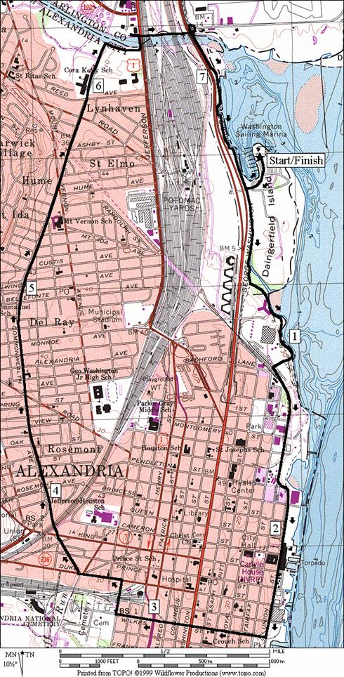
Daingerfield Island
At Daingerfield Island,
you can get lunch at the snack bar, picnic outside, watch the airplanes
take-off from National Airport,
and watch the sailboats and windsurfers blow by. Not actually an island, the flat and mostly
wooded park is the site of the first permanent Alexandria
settlement; established by Simon Pearson in 1696. Many earlier settlers in the area were killed
in wars with Powhatan and Susquehannock Indians. Diphtheria, malaria, and stormy weathers
which killed crops, took their tolls on many others. The park is just north of present day Old
Town Alexandria, off the George Washington Parkway
and the Mt. Vernon Trail. It=s also
within easy reach of Four Mile Run and the trails there.
The City of Alexandria
history actually dates even further back in time to 1669 when the Governor of
Virginia awarded the land to an English ship captain who had brought 120 people
to live in Virginia. The captain turned the land over for 6,000
pounds of tobacco and cask to John Alexander.
There was an overlap of the lands awarded, with lands previously owned
by Margaret Brent. She was the first
female barrister in America
(1640) and a Asubstantial@ landholder. She also was the first suffragette, having
argued unsuccessfully for the right to vote in the Maryland
assembly before moving to Virginia
with her brother Giles. The land dispute
was resolved by John Alexander=s
heirs for an additional 10,500 pounds of tobacco which went to Brent=s estate. It wasn=t
until 1749 that the township was petitioned and named Alexandria (http://ci.alexandria.va.us/about-alexandria/about.html). The original surveying was assisted by the
then teenaged George Washington. The
eventual first President was drilling troops in Market Square six years later.
The city became one of the main trading ports for the colonies. Robert E. Lee grew-up there in the early
1800's when it was temporarily part of the newly established District of Columbia. The federal
government ceded it back to Virginia in 1847. Slave
auctioning was held in the city.
Benjamin Hallowell, a Quaker teacher, and six others formed the Lyceum
Company in 1834 which promoted public education through a series of debates
which Aoften concerned biology and philosophy@ (Office of Historic Alexandria: http://ci.alexandria.va.us/oha/lyceum/ly-whatis.html). Politics and
religion were not discussed due to lack of civility manageable on those
topics. During the Civil War, the city
was occupied by the North and made into the Restored Government of Virginia,
representing 7 federally controlled Virginia counties.
Electricity came to Alexandria, in 1889, and electric streetcars operated by 1892. In 1920, the Torpedo Factory was built. It was used in WWI and used as a munitions
factory during WWII. In 1974, it was
turned into a very successful arts center.
Among the modern accomplishments listed by the city include the defeat
of a plan for 76,000 seat football stadium at Potomac Yard. Shopping malls have been built there
instead. The Saint Patrick=s Day and the Fourth of July celebrations are yearly city
highlights.
Getting There
From Northern Fairfax County, VA or Montgomery County, MD
Exit the Capitol Beltway, I-95,
southbound onto the George
Washington Parkway. After 14 miles, before reaching Old Town
Alexandria, turn left into Daingerfield Island Park. Follow the road
around to the left. Park and start near
the restrooms and water fountains.
From Southern Fairfax County, VA
Exit the Capitol Beltway, I-95,
northbound onto Henry
G. Shirley Highway
(I-395). After
approximately 9.5 miles exit southbound onto the George Washington Parkway. After 3.1 miles, before reaching Old Town
Alexandria, turn left into Daingerfield Island Park. Follow the road
around to the left. Park and start near
the restrooms and water fountains.
From Prince Georges County, MD
Use the Capital Beltway (I-95), to
get to Rte. 50 west or I‑295 north.
From either, take the westbound Southeast Freeway (I-395) after 11 miles
or approximately 6 miles respectively.
Follow the Southeast Freeway across
the river into Virginia. Do not use the
express lanes. Take the second exit ramp
immediately after crossing the bridge, onto the southbound George Washington Parkway. After 3.1 miles,
before reaching Old Town Alexandria, turn left into Daingerfield Island Park. Follow the road
around to the left. Park and start near
the restrooms and water fountains.
Area Routes
Oronoco Bay Park (3.55 or 3.5 miles, III)
The City of Alexandria has continually worked at bettering it=s Potomac River waterfront properties.
An unusual amount of land has been made publically
accessible. On just about any summer
weekend, you can find lots of people out strolling, shopping, playing
volleyball, or just sitting, relaxing and taking it all in. Oronoco Bay Park is one of the city=s newer additions.
Come out from Daingerfield Island on the Mt. Vernon Trail, past the wetland, and the power
plant along the riverside. Just before
you reach the railroad tracks, turn left on the Riverside Trail that
switchbacks down to the riverside into Oronoco Bay Park. Cycling is not
allowed in the park. At first the
bluestone trail is squeezed in between buildings and the river, right on the
water=s edge. Rounding a
bend past some sculptures, cross a restored canal lock. Between 1843 and 1886, the canal was used to
carry goods from Alexandria ports 7 miles, 38 vertical feet through 4 lifts, all the
way to Georgetown. Oronoco,
was the name of a variety of tobacco that was traded. The park widens at this point and the trail
winds past benches through it to the end at Union and
Pendleton streets. Turn around to the
right on the Mt. Vernon Trail following the railroad tracks. To return optionally cross the tracks to stay
on the Mt. Vernon Trail going back the way you came out, or continue straight
with the tracks on what was the old Mt. Vernon trail. If you go
straight, the trail climbs gently around the power plant, getting near to the George Washington Parkway. It drops again to
join the current Mt. Vernon Trail to get back to Daingerfield Island.
Commonwealth (7.85 miles, VII)
This largely urban route goes
along the streets of Old Town Alexandria, and along the on-the-street bike
route of Commonwealth
Avenue. Follow the Mt. Vernon Trail south from Daingerfield Island (see Oronoco Bay Park). At Pendleton St., the trail runs out and you must use Union St. You will pass
Founder=s Park on the left.
When I used to bicycle commute through here, seeing the sun rises over
the park and river were wonderful. For a
while, you can use the sidewalks, but as you near the more touristed
areas near King St., you may find them too busy. Note the high water marks on the corner of
the Torpedo Factory (now an arts center).
The streets flood regularly during big spring runoffs and storms.
A third of a mile past King St., turn onto the trail on your right in Pomander
Park, and into the lighted, former railroad tunnel. The trail ends after the tunnel and you must
use sidewalks for the next few miles. A
very short segment passes through an area of low income housing. After crossing Patrick St., Rte. 1, you=ll
near the old cemeteries of the city. Penny Hill Cemetery dates back to 1796.
Some side streets eventually put you on Daingerfield Rd. After crossing King Street, the city congestion subsides and Daingerfield Rd. becomes Commonwealth Ave. Commonwealth Ave. is a mostly residential street. Though a main throughway, it is a bike route
and relatively quiet. Water and restroom
stops are available at two recreation centers.
The road is also used for Alexandria=s Turkey Trot race.
At the end of the road, turn right toward the river and Route 1 on a
short part of the paved Wayne F. Anderson Trail. Connect with the Four Mile Run Trail to get
under the highways and railroads, then take the Mt.
Vernon Trail back to Daingerfield Island.
Nearby and Connecting Zones
Cameron Run Regional Park
Aurora Hills
Belle Haven Park and Marina
What to do Afterward
Food and Drink
Potomac Landing - on Daingerfield Island; indoor/outdoor - 703 548-0001
Hard Times Café - The founding
store of the locally famed chilli chain restaurant -
703 683-5340
Fish Market - 703 836-5676
Deli-on-the-Strand - fresh bread
subs and sandwiches - 703 548-7222
Al=s Steak House - Alexandria - 703 836-9443
and many, many more in Old Town Alexandria
Entertainment and Edification
Gadsby=s Tavern Museum - (703) 838‑4242
Carlyle House Historic Park -
(703) 549‑2997
Lyceum - 201 S Washington St - (703) 838‑4994
Alexandria Archeology - (703) 838‑4399
Birchmere - live folk music near Crystal City - 703 549-5919
Washington Sailing Marina - boat and windsurfer rentals at Daingerfield Island - 703 548-9027
Gravelly Point - view the
airplanes at the airport
Oronoco Bay Park
Distance: 3.55
or 3.5 miles
Rating: III; paved
and unpaved riverside trails; mostly sunny and flat
3.55 Mile Route
0.0 from the parking lot near the restrooms go
out the exit road
L 0.15 Mt Vernon Trail
BL 0.6 trail X (triangle); R is old Mt Vernon Trail
concrete bridge (! blind corner ;mile 1.0 is at wooden
bridge
L 1.2 River Walk Trail (no bicycling)
1.5 canal lock
R 1.8 Pendleton St; leave Oronoco Bay Park; Mt Vernon Trail
R 1.8 paved Mt Vernon Trail head (cut the corner)
<*
XS 2.1 cross the RR tracks at 1st St to stay on the Mt Vernon Trail
2.3 trail X on L crosses tracks; River Walk Trail
on R
2.55 concrete bridge w/blind corner
BR 2.9 trail X (triangle); L is old Mt Vernon
Trail
>*
R 3.35 road to the Washington Sailing
Marina/Daingerfield Island
3.55 parking lot near restrooms/water

*3.5 Mile Route
S 2.1 1st St; leave Mt Vernon trail as it crosses the RR tracks; S is
old the Mt Vernon Trail
2.3 trail X on R crosses
tracks to Mt Vernon trail & River Walk Trail
BR 2.6 E Abington Dr
BL 2.85 trail X (triangle); Mt Vernon Trail
(pickup cues at mile 3.35 on 3.55 mile route)
Oronoco Bay Park
Commonwealth
Distance: 7.85 miles
Rating: VII;
mostly city sidewalks with some paved trails
0.0 from the parking lot near the restrooms go
out the exit road
L 0.15 Mt Vernon Trail
BL 0.6 trail X (triangle); R is old Mt Vernon Trail
1.0 concrete bridge w/blind corner (!); mile 1.0
is at wooden bridge
1.2 River Walk Trail on L (no bicycling)
XS 1.4 cross RR tracks at 1st St (unmarked)
BL 1.75 end of paved trail at Pendleton St
R 1.8 Union St
2.15 King St
R 2.5 Cameron Run Trail (tunnel)
2.6 S Royal St at end of tunnel; continue S on Wilkes St
2.85 S Washington St
2.9 begin trail at S Columbus St
3.0 Patrick St (Rte 1); end of trail; continue on
Wilkes St
R 3.2 S Payne St; go through auto barrier
L 3.35 Duke St (Rte 236)
R 3.6 Daingerfield
Rd
3.75 King St (Rte 7); Daingerfield Rd becomes Commonwealth Ave.
3.85 metro bridge underpass
4.45 E Braddock Rd
5.35 Mt Vernon Rec Center
(water)
5.5 Mt Vernon Ave
5.85 W Glebe Rd
5.95 Cora Kelly Rec Center
(water)
R 6.2 Wayne F Anderson Trail (paved)
L 6.4 sidewalk on Jeff Davis Hwy, Rte 1
L 6.45 trail X on L to Four Mile Run Trail
UL 6.5 Four Mile Run Trail; go under bridges for Rte
1, RR=s & parkway
L 6.8 Mt Vernon Trail (triangle X)
L 7.65 park road to the Washington Sailing Marina/Daingerfield
Island
7.85 parking lot near restrooms/water
Commonwealth