Bluemont Junction
Park
Competition takes many forms, shaping our surroundings and
ourselves. Not only do runners compete
in races but transportation routes compete for travelers and dollars. It can happen over many years or more
quickly. For instance, railroads quickly
replaced canals and waterways as the primary routes of commerce in the
1800's. George Washington’s dream of the
C&O Canal
required decades of toil to complete but proved not to be needed soon after it
was finished. The Baltimore & Ohio Railroad
proved to be cheaper and faster.
Furthermore, the railroad redirected the trade of Virginia’s
farm goods to ports at Baltimore
instead of Alexandria. Wanting to take advantage of the technology
and to continue to compete, the Washington & Old Dominion Railroad
(W&OD) was built from 1847-1874. It
traversed from Alexandria to the
edge of the Blue Ridge Mountains in Purcellville. Being only modestly successful in the wake of
other railroads, and then the highway system, W&OD passenger service was stopped
in 1951, and in 1968, the railroad was abandoned
altogether.
Just as the obsolete C&O
Canal came to be a valued
recreation route, the W&OD railroad grade and right-of-way was converted
into a recreational trail. The paved
trail starts in Shirlington and goes 44.64 miles to Purceville (note that the
trail is posted to be over 45 miles but was shortened by the bridge over Rte. 7
and other minor modifications over the years), passing through city, suburb,
city, and farm fields; back and forth all the way to Purceville. It remains the safest way to get out of Washington
D.C. when on foot or bike headed west. It’s very popular with all sorts of
people. Runners, cyclists, in-line
skaters, walkers, and horse back riders use it.
The paved trail is paralleled most of the way (except in Arlington)
by a bluestone surfaced bridal path.
In Arlington,
the W&OD trail is mostly used by runners, walkers, and recreational and
commuter cyclists. It’s a fairly safe,
green ribbon cutting through the suburbs.
Bicycling police regularly patrol it.
Colored numbered posts line the trail in Arlington
so that police can identify segments and respond quickly. At the police substation in a caboose near
the Bluemont Junction, a detailed Arlington Trail map is available. The Four Mile Run Trail parallels and
sometimes shares the W&OD Trail from Shirlington to East Falls
Church. Walkers tend to
prefer it over the W&OD Trail.
Bluemont Junction is the location of a W&OD railroad spur
intersection that went to Ballston. The
spur has also recently been converted into a paved recreational trail. Various running clubs meet at Bluemont
Junction Park
to take advantage of these trails and others.
Ballfields, tennis courts, water, restrooms, cooking grills and other
items are located in the park.
Getting There
From Northern Fairfax County,
VA or Montgomery
County, MD
Exit the Capital Beltway onto Rte. I-66, headed east. If you’re coming from Montgomery
County or the northernmost parts of
Fairfax County,
you will have to use the Washington and Dulles Access Expressway for 2.7 miles
to get onto Rte. I-66; it’s a left exit off the beltway. After 6.1 or 4 miles on Rte. I-66
respectively, exit onto Fairfax Dr. Turn right soon after the exit ramp onto North
Glebe Rd.
Turn right at the next traffic light onto Wilson
Blvd. After
1.1 miles at the bottom of the hill, turn left on Manchester St. Turn left
again into the park and park your vehicle.
Start from the 4-way trail intersection near Wilson
Boulevard.
From Southern Fairfax County,
VA
Exit the Capitol Beltway, I-95, northbound onto Henry
G. Shirley Highway (I-395). After approximately 6.4 miles, exit onto S. Glebe
Rd., headed north toward Ballston. Follow S. Glebe Rd.
approximately 3 miles and turn left on Wilson Blvd. After 1.1 miles at the bottom of the hill,
turn left on Manchester St. Turn left again into the park and park your
vehicle. Start from the 4-way trail
intersection near Wilson Boulevard.
From Prince
Georges County,
MD
Use the Capital Beltway (I-95), to get to Rte. 50 west or I‑295
north. From either, take the westbound
Southeast Freeway (I-395) after 11 miles or approximately 6 miles
respectively. Follow the Southeast
Freeway across the river into Virginia. Do not use the express lanes. Approximately 3 miles after crossing the
river, exit northbound onto S. Glebe Rd. Follow S. Glebe Rd.
approximately 3 miles and turn left on Wilson Blvd. After 1.1 miles at the bottom of the hill,
turn left on Manchester St. Turn left again into the park and park your
vehicle. Start from the 4-way trail
intersection near Wilson Boulevard.
Area Routes
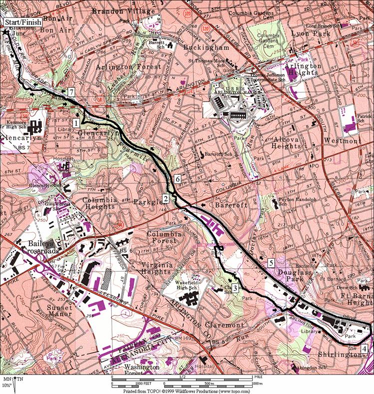
Four Mile Run South
(7.75, 3.85 or 6.55 miles, VII, III, or V)
Four Mile Run is not four miles long. The stream bearing the name has headwaters in
Falls Church. By trail, it’s over seven miles long from its
mouth on the Potomac River, near National
Airport to Falls
Church. The
Four Mile Run Trail parallels the stream, and for part of the way also
parallels the W&OD Trail. As a
trail, the Four Mile Run Trail is older, more hilly
and more often closer to the stream than the W&OD Trail is. Both are paved and for short segments, share
the same stretch of trail. This route
goes out on the Four Mile run trail, downhill to Shirlington, then returns on the more graded W&OD Trail. Most the way out is shady and pretty. There are natural rocky stream beds as well
as a few man made pools to see. The
waters are stocked with trout in the spring for young fishers. The turnaround for the route, at the
beginning of the W&OD Trail, is at first not as pleasant as the Four Mile
Run Trail. The trail there is in a sunny
industrial corridor, and the nearby housing is a little disheveled in
appearance. It gets much better soon
however. You don’t have to go as far as
the beginning of the W&OD Trail to turn around since there are two earlier
turnaround options listed. The return on
the W&OD Trail after crossing back across Columbia Pike,
is where it gets much more pleasant. In
one area, the rocky Four Mile Run is visible below on the left side of the
trail, while a wetland area with Red Winged Blackbirds in it is on the right. Some mile markers are slightly
off on the Four Mile Run Trail however they are accurate on this part of the
W&OD Trail.
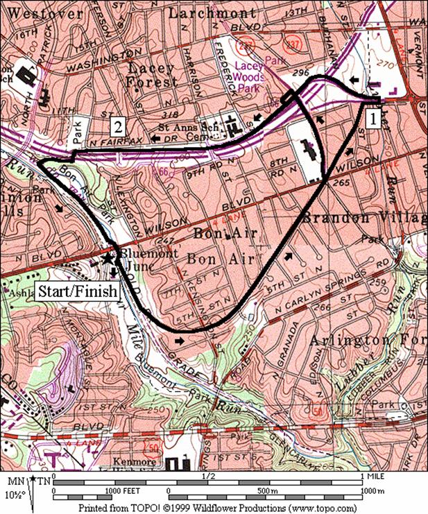
Bluemont Bypass (2.7 or 2.5 miles, II)
The Bluemont Bypass Trail, on an old railroad spur, is “J”
shaped. It curves as it climbs away from
the W&OD Trail on an easy grade toward Ballston. On either side of the trail are quiet
residential streets. There are a few
road crossings. An option of the route
avoids part of the worst of these, at a traffic light on George
Mason Dr.; in order to shorten the route. Going on further up the trail, another
intersection and traffic light at Fairfax Dr.
will also likely slow you down. The end
of the Bluemont Bypass Trail intersects the Custis Trail. The Custis Trail can be followed to the
right, 3.3 miles to Rosslyn, or left as on this route, 1.05 miles to the
W&OD Trail. On the route, the Custis
Trail closely parallels Interstate 66.
It is more pleasant than it may sound however. Protective sound barriers and trees make it
comfortable. The return is on the
W&OD Trail with a gradual downhill grade.
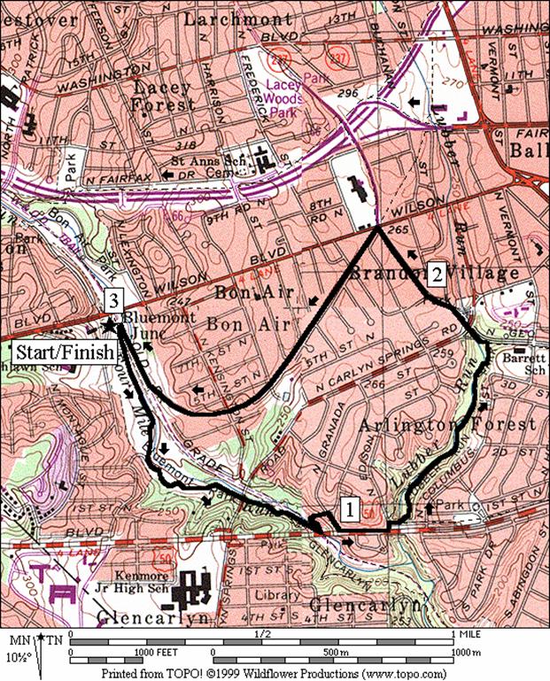
Lubber
Run from Bluemont Junction (3.0 miles, II)
One of the tributary streams of Four Mile Run is Lubber
Run. Somewhat hidden away, you must
descent into the little wooded park regardless of which end you approach it
from. The stream tunnels under Arlington
Blvd., Rte. 50, before joining Four Mile Run. Water and restrooms are available in Lubber
Run Park
also. The route leaves the W&OD
Trail near Arlington Blvd.
then makes a counterclockwise loop through Lubber
Run Park. Return on the easy downhill grade, to
Bluemont Junction on the Bluemont Bypass Trail.
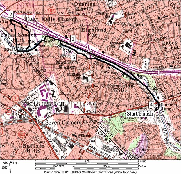
Four Mile Run North (4.05 or 2.4 miles, III or
II)
As you head north from Bluemont Junction, the W&OD Trail
and the Four Mile Run Trail share the same path. Not far past Wilson
Blvd. the Four Mile Run Trail separates
again. For this elongated figure eight
route, continue straight on the W&OD, past the garden on the right in Bon
Air Park,
and past the intersection of the Custis Trail, also on the right. Ahead, the W&OD trail gradually climbs a
long straight and often sunny stretch along Rte. I-66. Sound barriers hide the highway. Before the end of this stretch, the Four Mile
Run Trail, also known as the John Marshall
Trail joins back with the W&OD
Trail. As you near Falls
Church the trails leave I-66 and split again. As you
pass a soccer field, you must turn right and cross the stream to stay with
W&OD Trail. Instead go straight on
the Four Mile Run Trail, also known as the City of Falls
Church Trail at this point. Doing so avoids a steeper
climb on the W&OD Trail. At the end
of the City of Falls Church/Four Mile Run Trail, a segment on residential
streets returns you to the W&OD Trail and is the turn around point. Turning right, the W&OD is along I-66 for
a short stretch, then it is on the road as it goes
downhill past the East Falls Church metro station. The trail begins at the end of the road and
joins the Four Mile Run Trail again to complete the top of the figure eight
loop. Heading back down, the trail nears
I-66 again. Turn right at the sign for
the John Marshall/Four Mile Run Trail.
Because it’s shadier, further from the highway, nearer to the creek, and
because it has curves to it, it’s a little nicer than the W&OD Trail which
is just parallel to it. When the trail
appears to end, you must cross Ohio Dr. and run on Four
Mile Run Dr. for a little way. The trail continues at the end of that and eventually
joins the W&OD Trail again, before Wilson Blvd.
Nearby and Connecting Zones
Thomas Jefferson Community Center
Iwo Jima Memorial
Aurora Hills
Idylwood Park
What to do Afterward
Food and Drink
Lebanese Taverna - 703 241-8681
Uptown Bakery - 703 527-6262
Halteh’s Pizza - 703 979-1109
International House of Pancakes - in Ballston
Entertainment and Edification
Bon Air Park garden - off the W&OD
Long Branch Nature Center - 703 228-6535
Arlington Arts Center - 703 524-1494
Four Mile Run South
Distance: 7.75, 3.85 or 6.55 miles
Rating: VII, III, V; mostly shady, paved, stream
valley and railroad grade trails
7.75 Mile Route
R 0.0 from the parking lot go southeast on the
W&OD Trail
0.2 wooden bridge on L to Bluemont Junction
Trail (water)
R 0.4 at parking to stay on W&OD Trail
0.65 underpass Carlin Springs Rd
S 0.75 W&OD Trail goes L
BR 0.85 merge w/W&OD Trail
0.9 trail X on L; underpass Rte 50
R 0.95 Four Mile Run Trail past the Rte 50
underpass; uphill
1.05 trail X on R to 2nd St &
Jefferson St
BR 1.3 at X w/W&OD Trail; down to the parking
lot & the creek
1.4 Mile Marker 3; trail X on R to bridge
1.65 concrete bridge over creek
1.95 concrete bridge over creek
<*
2.0 trail X on L to W&OD Trail (unmarked)
BR 2.15 after underpass of Columbia Pike
2.5 Mile Mark 4 before bridge
L 2.55 George Mason Dr South (bridge)
L 2.6 Four Mile Run trail head (marked Barcroft
Trail); merge trails
2.9 Mile Marker 4.5 (outhouse)
L 3.35 at T; Walter Reed Dr
<**
R 3.4 at TL for Arlington Mill Dr
3.9 Randolph
Rd on R; Mile
Marker 5.5
L 4.1 Shirlington Rd; use sidewalk
CL 4.15 at Four Mile Run Dr onto the W&OD Trail; start of W&OD Trail
4.7 Walter Reed Dr
>**
5.3 George Mason Dr South
5.75 Columbia Pike
5.9 trail X on L to Four Mile Run Trail; on R
to 9th
St
>*
6.05 trail X on R to 7th St
6.8 trail X on L; Four Mile Run Trail
6.85 Rte 50 underpass; trail X on R
6.85 Four Mile Run Trail on L
BR 7.0 merge w/Four Mile Run Trail
7.05 underpass Carlyn Springs Rd
CR 6.9 at parking, to stay on W&OD Trail (water,
restrooms & phone)
7.55 wooden bridge on R to Bluemont Junction Trail
(water)
7.75 4-way X; Bluemont Junction Trail merges on R;
parking on L

*3.85 Mile Route
L 2.0 trail X on L to W&OD Trail (unmarked)
L 2.0 W&OD Trail; S is to 9th St (pickup cues at mile 6.05 on 7.75 mile route)

**6.55 Mile Route
XS 3.4 at TL for Arlington Mill Dr
CL 3.5 Four Mile Run Dr onto the W&OD Trail;
(pickup cues at mile 5.3 on 7.75 mile route)
Bluemont Bypass
Distance: 2.7 or 2.5 miles
Rating: II; paved railroad grade and roadside
trails; some sidewalks and road intersections
2.7
Mile Route
0.0 from the 4-way trail X near Wilson
Blvd; Bluemont Junction Trail; toward the caboose
0.1 caboose on L (police substation)
0.2 wooden
bridge on R to W&OD Trail (water)
<*
CL 0.8 George Mason Dr
R 0.85 Bluemont
Bypass Trail continues on R
R 0.95 Fairfax Dr
UL 1.05 cross Fairfax Dr
at Wakefield Dr TL
1.1 trail X on R to Washington Blvd;
cross over I-66
L 1.25 Custis
Trail at T
1.35 underpass
George Mason Dr
1.4 trail
X on R toward George Mason Dr
>*
2.0 underpass
pedestrian footbridge over I-66
R 2.15 at
T after passing under I-66
L 2.3 W&OD
Trail
2.4 trail
X on R; Four Mile Run Trail
2.7 underpass
Wilson Blvd
2.7 4-way
trail X; Bluemont Bypass Trail & W&OD Trail
*2.5
Mile Route
L 0.8 George Mason Dr
L 1.1 10th St;
after I-66 overpass
L/R 1.15 spur
trail on L to Custis Trail; R on Custis Trail (pickup cues at mile 2.0 on 2.7
mile route)
Lubber Run From Bluemont Junction
Distance: 3.0 miles
Rating: II; paved stream valley and railroad
grade trails; some sidewalks
R 0.0 from
the 4-way trail X go southeast on the W&OD Trail
0.2 wooden
bridge on L to Bluemont Junction Trail (water on R)
R 0.4 at
parking lot to stay on W&OD
0.65 underpass
Carlin Springs Rd
L 0.75 W&OD
Trail goes L; Four Mile Run Trail goes S
0.85 Four
Mile Run Trail merges from the R
L 0.9 trail
X on L at the Rte 50 underpass (unmarked); goes to N
Greenbriar St
R 0.95 Granada St
L 1.05 Arlington
Blvd, Rte 50 (use sidewalk)
L/R 1.15 Edison St
L 1.2 Lubber
Run Trail
1.4 trail
X on R
BL 1.45 to
go behind the amphitheater (water & restrooms)
1.1 wooden
bridge on L
1.55 concrete
bridge crosses Lubber Run
BL 1.6 away
from trail X on R that crosses Lubber Run
BL 1.7 after
wooden bridge that crosses Lubber Run
L 1.75 George Mason Dr
L 2.2 Bluemont
Bypass Trail at the intersection w/Wilson Blvd
2.4 trail
X on L to Greenbriar St
2.8 trail
X on L over wooden bridge to W&OD Trail (water on L)
2.9 caboose
on R (police substation)
3.0 4-way
trail X; W&OD Trail; parking lot on L(water, restrooms, phone)
Four Mile Run North
Distance: 4.05 or 2.4 miles
Rating: III or II; mostly paved trails with
some residential streets
4.05
Mile Route
L 0.0 at
4-way trail X; go west on the W&OD Trail under Wilson
Blvd
0.05 Wilson Blvd
underpass
0.35 Four
Mile Run Trail on L (return route)
0.45 Custis
Trail on R (water)
0.8 trail
X on L to Four Mile Run Trail (phone)
1.05 trail
X on L to John Marshall
Trail
1.15 trail
X on L to pedestrian footbridge over I-66
<*
1.2 John
Marshall Trail/Four Mile Run Trail on L before the concrete bridge (return
route)
BR 1.4 at Roosevelt
St (unmarked) to follow Four Mile Run
Trail/W&OD Trail
1.5 trail
X on L to outhouse & parking for soccer field
S 1.6 W&OD
Trail goes R (return route); S is City of Falls Church
Trail/Four Mile Run Trail
R 1.7 Van
Buren (unmarked)
1.7 Four
Mile Run Demonstration Trail on L
L/R 1.95 L on 19th
Rd; R on Vanderpool St
R 2.0 W&OD
Trail (at the end of Vanderpool St)
L 2.2 Tuckahoe
St; East Falls Church Metro Station ahead
2.35 paved
W&OD Trail continues
L 2.4 at
T to continue on W&OD Trail/Four Mile Run Trail
BL 2.65 at Roosevelt
St (unmarked)
R 2.8 John
Marshall Trail/Four Mile Run Trail on R after concrete bridge
>*
L 3.15 11th Rd N
S 3.2 cross
Ohio St; use walkway to go down
to Four Mile Run Dr
3.25 trail
X on L to W&OD Trail (phone)
3.35 paved
Four Mile Run Trail continues
3.65 paved
trail ends; go S onto N Arlington Dr
L/R 3.7 at
paved trail to join W&OD Trail
4.0 underpass
Wilson Blvd
4.05 4-way
trail X; parking on R
*2.4
Mile Route
L 1.2 John
Marshall Trail/Four Mile Run Trail on L before concrete bridge (pickup cues at
mile 3.15 on 4.05 mile route)