Battery Kemble Park
Battery
Kemble Park
has literally gone to the dogs. The affluent
residents of northwest Washington,
stop off here to run and socialize their pets, to socialize themselves, and to
enjoy the open space. It’s quite a
pleasant place as long as you like dogs.
In the space of an hour, I observed 20 or 30 dogs along with their
masters. Everyone speaks dog. The excited dogs bark at one another and the
owners talk in their special dog voices
to coo the right social interplay. The
dogs don’t always obey even if they do listen.
All that I saw were friendly, and not one chased me; not even the
owners. The friendliness was accompanied
by creativity. I heard dog names of
Nimzo, Rasputan Greta and others.
Masters used lacrosse sticks to throw chase balls up the grassy bowled
hill. One person, not interested in the
dogs, did attract dog attention. He used
the as yet unpopular mountain in-line
skates, to race down the grass hill in a manner that skiers would ski it. Fortunately he did not fall even after many
runs down the slope.
The
hilly mile long park, is part of the National Park system. Primarily a stream valley, the top end near American
University is at 380ft in
elevation; near some of the highest and most expensive land in the city. The lower end at under 100 ft. abuts the Chesapeake
and Ohio (C&O) National
Historical Park
near Fletcher’s Boathouse. The C&O
Park is along the Potomac
River so, one can cover almost 400 vertical feet in a short
distance. Some of the hills are
unavoidable, but some horizontal and some well graded trails make it more
manageable. Bicycles are not allowed on
the park trails.
Getting
There
From
Montgomery County, Maryland
Exit
the Capital Beltway (I-95) at the River Road
(Rte. 190) and Cabin John Parkway
exit, onto the Cabin John Parkway. The Cabin John
Parkway merges onto the southbound Clara
Barton Parkway after 1.3 miles.
At the Chain Bridge intersection, 3.35 miles later, the road changes its
name to Canal Road. This intersection also is as far as you can
go southbound during evening rush hour, because during that time, traffic is
one way northbound, leaving D.C. (cut
through the city or see directions from Virginia
below to get there during evening rush hour).
Turn left one-half mile after Chain Bridge onto Arizona
Avenue. At
the next traffic light, turn right onto MacArthur
Boulevard.
After 0.45 miles, turn left onto Chain Bridge
Rd. Turn
right after 0.85 miles into the park, then proceed to the only parking
lot.
From
Northern Fairfax County, Virginia
on the Capital Beltway
Take
the George Washington Parkway
southbound for 8.5 miles to Francis Scott
Key Bridge. After crossing the bridge into Georgetown,
turn left onto M Street. Seven tenths of
a mile later, turn left onto MacArthur Boulevard. Turn right after 1.5 miles onto Chain
Bridge Road.
After 0.85 miles turn right into the park, then proceed to the only
parking lot.
From
Southern Fairfax County, Virginia
Exit
the Capitol Beltway, I-95, northbound onto Henry G.
Shirley Highway (I-395). After approximately 9.5 miles, take the left exit
just before the 14th Street
Bridges, northbound onto the George Washington Parkway. Stay in the left lane following the signs
toward Arlington Memorial
Bridge. At the next merge however, bear right to go
under Memorial bridge. After crossing
under Memorial bridge, at the next merge move to the left lane following signs
for Rte. 50 west. Quickly move to
the right lane and take the next exit onto Meade St. This becomes Lynn
St. before crossing the Potomac River
on Key bridge. At the light at the end
of the bridge, turn left on M Street.
Turn left again after 0.7 miles onto MacArthur
Blvd. After
1.55 miles, turn right on Chain Bridge Rd. After 0.85 miles turn right into the park,
then proceed to the only parking lot.
From
Prince Georges
County and the
Capital Beltway (I-95)
Take
New York Avenue (Rte. 50)
west (approximately 10 miles) to Mt. Vernon Square. Continue straight one block, then bear right
on Massachusetts Avenue,
and go 4.2 miles across the city. At Ward
Circle, take Nebraska
Avenue southwest toward American
University (to the left as you
enter the circle). After one-half mile
turn left onto Chain Bridge Road. After 0.4 miles, turn left in to the park and
proceed to the only parking area.
By
Metro Rail
The
nearest metro rail station is the Tenleytown station, 1.7 miles away. From it, take Wisconsin
Ave. to Tenley Circle. Turn right onto Nebraska
Ave. Turn
left on Chain Bridge Rd.,
then left again into the park.
Area
Routes
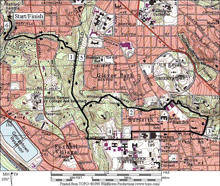
Crosstown Trails (6.05
miles, VII)
The
crosstown trails are the Wesley Heights Trail, the Whitehaven Trail, and the
Dumbarton Oaks Trail. They traverse
east/west and stay within narrow wooded strips of land along the tributaries to
Battery Kemble Run, Foundry Branch, and Rock Creek. Connecting Battery
Kemble Park,
Glover Archbold
Park, and Rock
Creek Park,
the strips of woodland are a surprising and hidden remnant of the city, long
ago developed elsewhere. Within them,
it’s hard to believe that your in the middle of the city, even when you can see
the houses and buildings on the nearby edges.
The parks appear relatively safe and pleasant. Many hikers use them.
A
lollipop course, the Crosstown Trails route starts from the low end of the
Battery Kemble parking lot. Facing the
exit road, the dirt Battery Kemble Trail is to the left, going down into the
woods. The first major trail
intersection, as well as all the dirt trails on the route, is well marked. The tree covered Wesley Heights Trail climbs
often steeply until it crosses Foxhall Rd. It then drops sometimes steeply down to the
Glover Archbold Trail. Along the way,
English Ivy covers the ground in many places.
Though somewhat handsome, the Ivy threatens the mature trees in the
park. The park service is trying to
eliminate it. Turning right on the
Glover Archbold Trail continue downhill but gather your strength for a climb
ahead. Turn left on the Whitehaven
Trail. It quickly climbs through the
forest, then past a community garden, to an open field. Dog owners gather in this field too. A water fountain diagonally across the field
points the way of the trail. Descend
past the field to another open field and the intersection of the Whitehaven
Parkway and 37th
Street.
Skip the trail on the other side of 37th
Street which goes up the very steep and badly
eroded hill. Instead use the parkway to
cross Wisconsin Avenue,
then pickup Whitehaven Road
(diagonally to the left). At the end of Whitehaven
Road, on the right side is the signed trail head
for both the Normanstone Trail, and the Dumbarton Oaks Trail. Take the Dumbarton Oaks Trail, going down the
switchback, past the swamp, the field, the stone bridge, and ending at Lovers
Lane. Come
back on the Montrose Park Connector (see more descriptions under Georgetown
Loops in the Rock Creek Park, Thompson Boathouse chapter, and Dumbarton Oaks in
the Rock Creek Park, Pierce Mill chapter).
The connector route is relatively flat which again offers you the chance
to gather strength for the climb back.
Going up the Glover Archbold Trail is relatively easy because it’s well
graded. The exertion will come as you push up back to Foxhall
Rd along the already traveled Wesley Heights
Trail. After Foxhall
Rd., you are practically home free.
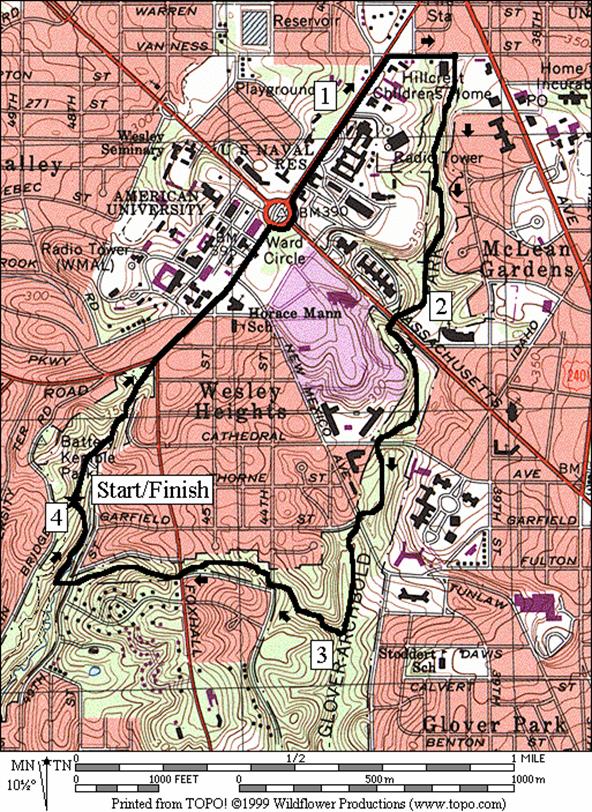
Wesley Heights (4.0
miles, IV)
Joseph
Cambell once remarked to the effect that the tallest structures in a city
represented what was most important to the people who lived in it. He had in mind European cathedrals as well as
skyscrapers in cities like New York
and Chicago. Washington
has the Washington Monument,
and laws preventing new buildings from being built taller than the capital
dome. The Washington Cathedral predates
that law however. It sits on higher
ground and definitely has its place on the skyline. Close to Battery
Kemble Park is even higher ground and some of the structures there are higher
than the cathedral. Some of the high
ones (not all are taller than the cathedral) include: antennae towers for the
U.S. Naval Security Station, WRC Television and Radio, National Presbyterian
Church, and Fox Television.
Get
your climbing to high places done early on this route that passes by some of
the above tall structures. From the low
end of the parking lot, with your back to the exit road, head through the lot
uphill and through the grass field ahead.
The Battery Kemble Trail will soon appear more defined as it goes up to
the top of the park. Use the sidewalks
on Nebraska Ave. to
continue. Many students run back and
forth from American University
here. Pass around Ward
Circle, then turn right at the Van
Ness Street.
From there, turn at the trail head for the Glover Archbold Trail. The trail is unpaved, but blazed. Shady and cool, it descends through the park
gently along Foundry Branch, crossing a few roads. Turn right onto the Wesley Heights Trail and
start climbing again. The trail tops out
and is steep near the intersection with Foxhall Rd. Finish with a steep descent into Battery
Kemble Park,
and a gentle climb to the parking lot.
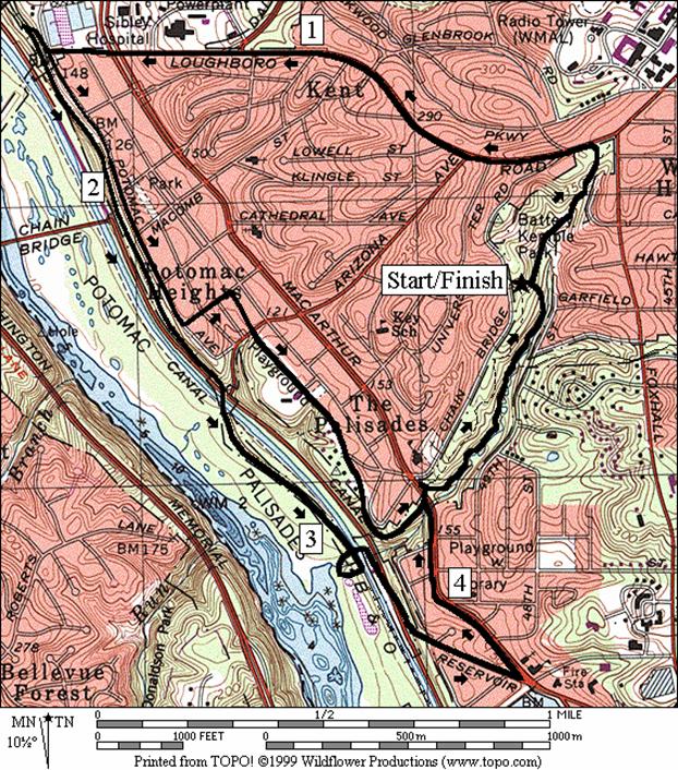
Washington Palisades (4.8
or 3.85 miles, V or IV)
Many
transportation routes parallel the Potomac River. Besides roads and trains, are three suitable
for foot or bicycle within easy reach of Battery
Kemble Park. Starting at the low end of the parking lot
with your back to the exit road, head uphill through the lot and through the
grass field at the other end. The
Battery Kemble Trail will soon appear more defined as you go up to the top of
the park. From there, bear left onto Loughboro
Road.. Note
that Nebraska Avenue
changes its name at Foxhall Rd
to Loughboro Road. Descend, sometimes quickly, on the tree
covered sidewalk. The road changes its
name again after Macarthur Blvd.
to Norton St. At the end of that, turn right onto an
informal unpaved path for the regular route or turn left onto Potomac
Avenue for a shorter route. The unpaved path for the regular route ends
shortly at the Capital Crescent Trail, not far from the Montgomery
County/Washington D.C. border. The paved
Capital Crescent Trail continues descending very gradually all the way to
Fletcher’s Boathouse where water and restrooms are available. Construction is currently underway here on
the bridge over the canal. The current
best way to Reservoir Rd.
is to circle to the right and go through the tunnel under the canal to the
intersection with Canal Rd. Crossing Canal Rd.
is dangerous if you are impatient. Wait
for the traffic lights that are out of sight in both directions, to clear the
way for you. Follow Reservoir
Rd. on the narrow sidewalk to MacArthur
Blvd., then make a sharp left. Still on a sidewalk, look for the Battery
Kemble trail head sign on the right side of the road; where the road becomes
wooded on both sides (the Discovery Creek Children’s Museum in the Conduit Road
Schoolhouse also cues the location of the trail and is the rejoin point for the
shorter loop. Climb the Battery Kemble
Trail to the parking area. Most of the
grade is gentle up to the parking lot.
For
the short route, Potomac Ave.
offers some good views of the river and the houses across it on the Virginia
side. A second and shorter dirt path on
the right also joins to the Capital Crescent Trail and can be used if you
change your mind and want a longer route after all. Staying on Potamac
Ave., turn left instead on Galena
Pl., then right on a dirt trail on an unpaved old
railroad grade. The dirt path eventually
leaves the grade turning up to MacArthur Blvd.
to become the Battery Kemble Trail and join the regular route.
Nearby
and Connecting Zones
Rock Creek Park, Thompson Boathouse
Rock Creek Park, District of Columbia, Military Road
Bethesda
Chesapeake and Ohio Canal, Lock 7
Iwo Jima Memorial
Donaldson Run/Potomac Overlook
Regional Park
What
to do Afterward
Food
and Drink
Guapo’s;
Tenleytown - Mexican Cuisine - 202 686-3588
Listrani’s
- Italian Gourmet - 202 363-0620
Entertainment
and Edification
Abner
Cloud House -
Fletcher’s
Boathouse - canoe rentals
Crosstown Trails
Distance: 6.05 miles
Rating: VII; hilly unpaved blazed trails,
sidewalks
R 0.0 from
the end of the parking lot, head south, downhill on the Battery Kemble Trail
(blue blazed)
L 0.2 Wesley
Heights Trail (faded orange and/or white blazes); before wooden bridge; up
steep hill
0.25 49th St
0.55 Foxhall Rd
R/L 0.75 44th St
L 0.9 at
trail X on R to cross the stream on stones
BL 0.95 after
crossing the creek on stones; trail X on R
R 1.0 at
T after crossing Foundry Branch; Glover Archbold Trail; blue blazes
L 1.5 Whitehaven
Trail; orange blazes
L 1.65 to
stay on trail; away from houses
S 1.9 across
field toward water fountain
2.0 trail
X
BR 2.2 onto
Whitehaven Pkwy at 37th
St
L/R 2.45 at Wisc
Ave; onto Whitehaven St
R 2.5 Dumbarton
Oaks Trail; continue down past switchbacks, wetland and the grassy field
R/L 2.85 at
stone bridge
R 2.9 Lover’s
Lane (unmarked)
R 3.05 R St at T
3.3 Wisconsin Ave
CL 3.75 38th St
CR 3.8 Reservoir Rd
R 4.2 Glover
Archbold Trail at 44th St
L 4.3 at
T after crossing the creek; to stay on the Glover Archbold Trail
4.55 Whitehaven
Trail on R
L 5.05 Wesley
Heights Trail; & cross Foundry Branch
BR 5.1 to
cross stream at trail X on L
R 5.15 after
crossing stream; trail X on L
R/L 5.3 at 44th
St
5.5 Foxhall Rd
5.8 49th
St
R 5.85 Battery
Kemble Trail
6.05 parking
Wesley Heights
Distance: 4.0 miles
Rating: IV
L 0.0 from
the low end of the parking lot, head uphill to the high end, across the grass
field to the Battery Kemble Trail (blue blazed)
R 0.3 onto
the sidewalk for Nebraska Ave
at Foxhall Rd
0.6 New Mexico Ave
R 0.7 counterclockwise
around Ward Circle on
sidewalks
R 0.8 Nebraska
Ave on sidewalks
R 1.2 Van Ness St
R 1.35 Glover
Archbold Trail head at bottom of hill; follow blue blazes
BR 1.95 at
open field before road
2.05 Massachusetts
Ave (down stairs after crossing; follow blue blazes)
L/R 2.5 Cathedral
Ave (unmarked)
L/R 2.65 New
Mexico Ave (unmarked)
R 3.0 Wesley
Heights Trail; cross Foundry Branch
BR 3.05 to
cross stream at trail X on L
R 3.15 after
crossing stream; trail X on L
R/L 3.25 at 44th
St
3.5 Foxhall Rd
3.75 49th
St
R 3.8 Battery
Kemble Trail
4.0 parking
Washington Palisades
Distance: 4.8 or 3.85 miles
Rating: V or IV; paved and unpaved trails;
uphill finish
4.8
Mile Route
L 0.0 from
the low end of the parking lot, head uphill to the high end, across the grass
field to the Battery Kemble Trail (blue blazed)
L 0.3 onto
the sidewalk for Loughboro Rd
0.55 Arizona Ave on L
1.15 Dalecarlia Pkwy on
R
1.45 MacArthur
Blvd; Loughboro Rd becomes Norton
St
<*
R 1.6 unpaved
trail along fence
L 1.65 Capital Crescent
Trail
2.05 trail
X on L to Potomac Ave
2.55 trestle
bridge over Canal Rd & canal
R 3.1 ramp
to Fletcher’s Boathouse
R 3.15 park
access road (gravel); through tunnel
3.4 cross
Canal Rd (!); becomes Reservoir
Rd; use sidewalk on R
XS 3.55 sidewalk
ends; use sidewalk on L
L 3.75 MacArthur Blvd
>*
R 4.2 cross
MacArthur Blvd at Conduit
Rd Schoolhouse on L; Battery Kemble Trail; sign is across MacArthur
Blvd; main trail is to R at split after entering
woods
4.6 Wesley
Heights Trail on R
4.8 parking;
Battery Kemble
Park

*3.85
Mile Route
L 1.6 Potomac Ave
1.9 trail
X on R to Capital Crescent Trail
L 2.25 Galena Pl
R 2.4 unpaved
trail head; old RR grade
2.5 bridge
over Arizona Ave
BL 3.1 RR
grade ends but the trail continues uphill (pickup cues at mile 4.2 on 4.8 mile
route)