Bethesda
Bethesda
is well known for its many small restaurants, the National Institute of Health
and the National Naval
Medical Center. It’s even written in as the scene of many
X-Files episodes. It’s an example of
what works in urban planning. As any
good city is, it’s built with foot traffic in mind. Besides the sidewalks, several trails
accommodate that. Most notably, and most
popular, is the Capital Crescent Trail.
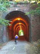
The trail literally runs right through the center of the downtown by
utilizing a tunnel. The trail was the
result of a rails-to-trails project. The
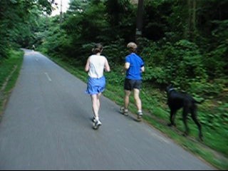
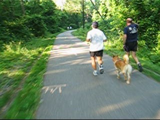
easy grade makes it very popular with runners, cyclists, in-line skaters,
walkers and strollers. The trail gets so
popular that police wanting to raise awareness for safety, once made local
television news by using radar guns to check the speed of passers by. No tickets were issued though many using
various forms of human power, were clocked over the
recommended speed limits.
Capital Crescent Trail Video
Getting
There
From
the Capital Beltway (I-495), take Old Georgetown Rd. (Rte. 187) southbound for
2.5 miles. Turn right onto Woodmont Ave. Just
after Bethesda Ave. 1/3 mile later, turn right into the parking lot. Parking is free on weekends but metered
during the weekday.
The
Bethesda metro rail station is very near the parking lot and the trail. From the station, turn left at the top of the
first and long escalator. Walk through
the Kiss-and-Ride to Woodmont Ave and turn left. The parking lot and the Capital Crescent
Trail are just on the other side of Bethesda Ave.
Area
Routes
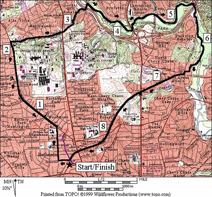
Cedar Lane (8.8 miles, VII)
This
loop combines the Rock Creek Trail with the Capital Crescent Trail for a no
nonsense route with good distance and surroundings. It’s an easy one to maintain a rhythm
on. Start from the intersection of the
Capital Crescent Trail and Bethesda Ave.
Pass the shops and pedestrians carefully, then turn up Arlington Rd. to
Old Georgetown Rd. The Old
Georgetown Rd. segment is not very pleasant. However, as you turn down West
Cedar Lane the surroundings improve as will your
speed. It’s gradually downhill for
nearly 1.25 miles to Rock Creek
Park. Once in Rock
Creek Park,
you continue a downward slope but the trail is relatively flat. Round the bends of Rock Creek’s partly tree
covered paved trail with only a few road crossings to slow you. The towering Mormon
Temple will eventually be visible
on your left. A small hill is
encountered after turning off the Rock Creek Trail onto the Capital Crescent
Trail. After that, the railroad grade
makes the rest of the return trip back up fairly easy. The grade after crossing Jones
Bridge Rd., is currently cinder but it is planned to be paved with
asphalt. The fenced-in trail at one point
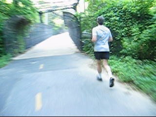
passes through the middle of a posh golf course. Note that the two-tenths of a mile tunnel
under Wisconsin Avenue near
the end of the route is open from 6AM to 10PM.
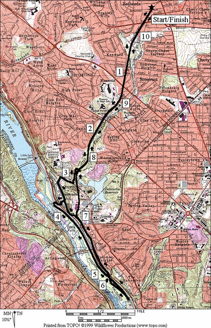
Loopy Way to Brookmont
(10.45 or 7.27 or
9.5 miles, IX or VI or VIII)
Brookmont is a sleepy little town off of MacArthur Blvd., above the Potomac River. Following trails, spin and trace figure
eight’s to get to and from there. First
take the Capital Crescent Trail. The
wide paved trail is easy and almost completely downhill with a very gentle
grade. Bridges get you over the worst
intersections at Bradely Rd. and River Rd. Along the side of the trail, runners have
worn a single track in the grass for much of the way. Turn left, then right just before the 6 mile
marker of the Capital Crescent Trail to the unmarked but paved Little Falls
Trail. The Little Falls Trail, passes
back under the Capital Crescent Trail, then takes a short hilly and circuitous
route to the intersection of MacArthur Blvd. and Sangamore Rd. Note
that a popular dirt short cut from the Capital Crescent Trail, on the right,
after the overpass of the Little Falls Trail, just after the bench, saves you
0.09 miles and one hill but continues the erosion of the hillside.
After
crossing MacArthur Blvd., turn right on the MacArthur Blvd. Trail.
This trail continues most of the way to Great Falls National Park. After only a short way however, at the bottom
of the hill turn left on Maryland Ave into Brookmont. The avenue intersects Broad St. a two lane
road with what used to be a railroad grade trail in the middle of it. Now there’s a dirt trail there. As you are on Broad St., look to the left. If the leaves are gone from the trees you’ll
see an impressive bend in the fast flowing Little Falls Branch visible
below. At the end of the dirt trail, is
the short loop option turnoff (this short loop option is not for everyone; see
below) that continues on the single remaining lane of Broad St. Turn right for the regular loop onto 61st
St. At its
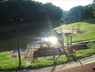
end and to the left, is a small unmarked asphalt path that goes down toward
Lock 5 of the C&O Canal. The trail is somewhat steep and it switches
back before crossing the Clara Barton Parkway. A spiral ramp lowers you further to a
footpath and finally Lock 5. Water is
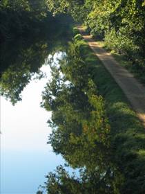
available here. Turn left on the C&O
Canal Towpath to continue. The gravel
surface of the towpath is soft on feet and tires but can get muddy too. After the Chain Bridge overpass, a heavy
trestle bridge once used for trains now carries the Capital Crescent
Trail. The second short option goes up
the stairs onto it. Continue on to Fletecher’s Boathouse (water and restrooms) for the regular
route, then turn around onto the Capital Crescent
Trail. The trestle bridge marks the
joining of the second short route. Well
past the trestle bridge, just after the second dirt trail on the right that
goes to Potomac Avenue (see Washington Palisades, Battery Kemble
Park), and before the D.C./Montgomery Co. line sign, the first short route
joins back via an inconspicuous dirt trail on the left. Continue up the Capital Crescent Trail,
through the tunnel under MacArthur
Blvd. and back up to Bethesda.
The
first short route option, which breaks off at Broad
St. in Brookmont, cuts
significant distance off the other routes.
At the end of Broad St.,
is another dirt trail. Dropping quickly,
the trail goes over a concrete bridge that is without rails and crosses
the Little Falls Branch. Do not cross if
you are afraid of heights or if surfaces are slippery from leaves, water or
ice. The concrete bridge is wide and
high enough to cause serious harm or drowning if you fall! After crossing, the dirt trail climbs steeply
at first, then more gradually to the Capital Crescent Trail, just inside the Washington
D.C. border.
|
|
|
|
|
|
Top
Left – CCT South of River Rd.
Top
Middle – CCT South of Mass. Ave.
Top
Right – C&O Towpath seen from the CCT trestle bridge.
Lower
Left – CCT Trestle Bridge over Canal Rd.
Lower
Middle – CCT tunnel under MacArthur
Blvd.
Lower
Right – Dalecarlia Reservoir from the CCT
|
|
|
|
|
|
|
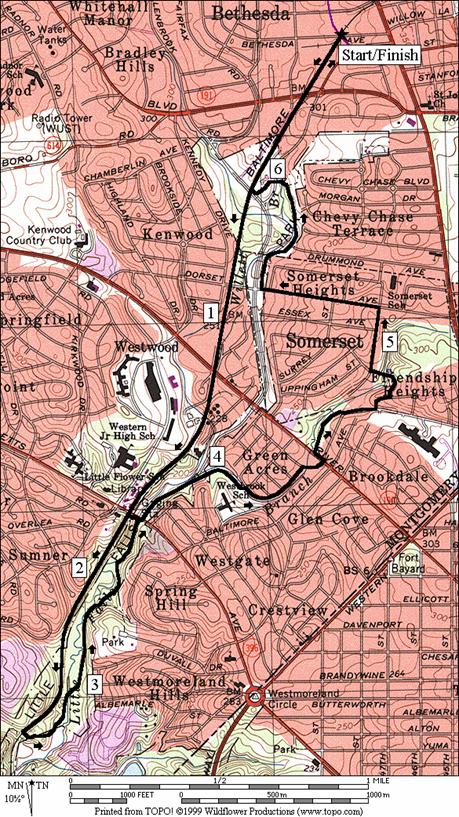
Little Falls Trail (6.7 or 5.4 miles,
VI or IV)
The
Little Falls Trail is a stream valley trail that parallels the Capital Crescent
Trail. Part of it is a more pleasant alternative to the
busier Capital Crescent Trail and when combined with the Capital Crescent
Trail, they together make a good loop.
The drawback to using the Little Falls Trail is that it is a little
hillier than the Crescent Trail and the paved portion of it is
discontinuous.
Start
by taking the Capital Crescent Trail toward Washington
D.C. just as the Loopy
Way to Brookmont route
does. Turn left before mile mark 6 onto
the unmarked but paved connector trail, then left
again on the unmarked Little Falls Trail.
The Little Falls Trail is smooth enough to in-line skate on, up to Massachusetts
Ave. but only recommended if you are well beyond
beginner ability. It is not recommended
for skating-on beyond Massachusetts Ave.,
necessitating an awkward scamper up a dirt embankment back to the Crescent
trail, or a return the way you came.
Along the way to Massachusetts Ave.,
a turn off up a short steep hill to the right, leads to Battery Bailey (1862),
one of the circle fort defenses of Washington D.C. At Massachusetts
Ave. the short route breaks off to return on the
Capital Crescent Trail up the dirt embankment.
After Massachusetts Ave.
the regular route and the Little Falls Trail are on shoulder of the Little
Falls Parkway. It is much less pleasant
but only for a short way. Bear right off
the parkway onto a grass and dirt trail that parallels along a small tributary
stream. It soon leads you to a ball
field in the back of Westbrook Elementary
School.
Stay to the left side of the field, where an opening and a bridge take
you to Little Falls Dr. Another few
turns and intersections lead you to the Willard
Avenue Park
and paved fitness trail. This small
trail first continues along the tributary, then leaves
it to Willard Ave. Turn left, then left
again on Park Ave. Passing in-between the buildings, the even
shorter Page Park
trail leads back to the tributary and crosses it to Warwick
Place. Turn
right, up the hill past homes to Dorset Ave
and turn left. At the bottom of Dorset
Ave., the Little Falls Trail starts again. Follow it up, past Norwood
Park to Bethesda Pool, and the
Capital Crescent Trail at the intersection with Little Falls Parkway. Finish the short stretch on the Capital
Crescent Trail to the downtown at Bethesda Ave.
Cedar
Lane
Distance: 8.8 miles
Rating: VII; paved and unpaved hiker-biker
trails, sidewalks; graded hills
L 0.0 from
the parking lot at Bethesda Ave
R 0.2 Arlington Rd
CL 0.65 Old
Georgetown Rd (Rte 187)
CR 2.05 W. Cedar Ln
2.75 Rockville
Pike (Rte 355); becomes Cedar Ln
BL 2.95 following
trail onto Elmhirst Pkwy
BR 3.05 to
continue paved trail
L 3.3 Cedar Ln
R 3.4 Rock
Creek hiker-biker trail; paved
4.0 trail
X on L to Connecticut Ave
4.15 Connecticut
Ave underpass
4.35 cross
Beach Dr
4.65 Kensington
Pkwy Trail on L
5.15 cross
Beach Dr (water)
R 5.45 at
T ; Jones Mill Rd and Stoneybrook Dr to stay on trail
(underpass I-495)
5.65 trail
crosses Jones Mill Rd
6.1 trail
X; Audubon Naturalist Society Nature Preserve on R
R 6.25 Georgetown
Branch Trail (Capital Crescent Trail; before the wooden bridge crossing Rock
Creek
L 6.4 Susanna
La (unmarked)
L 6.6 Jones Mill Rd
XS 6.6 at X
with Jones Bridge Rd; crosswalk
R 6.65 Georgetown
Branch Trail (Crescent Trail)
L/R 7.3 at Conn Ave to cross Conn Ave at
Chevy Chase Lake Dr
R/L 7.35 after
crossing Conn Ave; R on sidewalk/trail then L on
trail into woods
8.05 East-West
Hwy underpass
8.5 tunnel
begins (open 6AM-10PM)
8.7 tunnel
ends
CR 8.75 Bethesda
Ave at Woodmont Ave
L 8.8 Capital
Crescent Trail; parking
Loopy
Way to Brookmont
Distance: 10.45 or 7.3 miles or 9.5 miles
Rating: IX or VI or VIII; mostly paved
trails; some crushed gravel on the towpath
10.45
Mile Route
0.0 south
from the parking lot at Bethesda Ave
0.2 bridge
over Bradley Rd
0.6 Little
Falls Pkwy
0.9 Dorset Ave
1.15 bridge
over River Rd; mile mark 4.5
1.75 bridge
over Massachusetts Ave
L/R 2.6 paved
TR X on L to Little Falls Trail just before mile marker 6; R on Little Falls
Trail to underpass Cap Cr TR
BL 2.9 Sangamore Rd
CR 2.95 at MacArthur
Blvd onto paved trail
L 3.15 Maryland Ave
L 3.25 unpaved
RR grade at Broad St
<*
R 3.55 61st
StL/R
L/R 3.6 at
T; L on Ridge Rd; R on paved footpath to towpath (spiral bridge)
L 3.8 C&O
Towpath at Lock 5 (water & restroom)
4.65 Chain
Bridge Rd underpass
<**
5.15 trestle
bridge underpass; Cap Cr Tr
UR 5.6 onto
Cap Cr Tr at ramp to Fletcher’s Boathouse (water,
restroom, snacks)
6.1 trestle
bridge over C&O canal
>**
7.05 TR
X on R unmarked to Norton St
7.1 TR
X on L unmarked to Brookmont
>*
7.15 Montgomery
Co/DC border
7.5 tunnel
begins; under MacArthur Ave
7.8 paved
TR X on R to Little Falls Trail
8.65 bridge
over Massachusetts Ave
9.1 begin
bridge over River Rd
9.5 Dorset Ave
9.85 Little
Falls Pkwy
10.25 end
bridge over Bradley Rd
10.45 Bethesda Ave

R/L 3.55 continue
on pavement on Broad St
S 3.7 trail
head at end of Broad St;(! CAUTION no rails on bridge at 3.8)
3.85 TR
X on L
3.95 TR
X on R
L 3.95 Cap
Cr Trail (pickup cues at mile 7.15 on 10.45 mile route)

**9.5
Mile Route
R/L 5.15 steps
to trestle bridge; Cap Cr Trail (pickup cues at mile 7.05 on 10.45 mile route)
Little Falls Trail
Distance: 6.7 or 5.4 miles
Rating: VI or IV; mostly paved trails with
some sidewalks and short unpaved sections
6.7
Mile Route
0.0 south
from the parking lot at Bethesda Ave
0.2 bridge
over Bradley Rd
0.6 Little
Falls Pkwy
0.9 Dorset Ave
1.15 bridge
over River Rd; mile mark 4.5
1.75 bridge
over Massachusetts Ave
L 2.6 paved
TR X on L to Little Falls Trail just before mile marker 6; L on Little Falls
Trail (unmarked)
2.85 cross
Little Falls Cr on wood bridge
BL 2.9 at
TR X to stay on Little Falls Trail; stay in the stream valley park w/creek on L
3.2 wooden
bridge over creek to stairs on L; TR X on R to Battery Bailey
<*
R/L 3.55 R at
Mass Ave; L on Little Falls Pkwy; use R side shoulder
R 3.9 unpaved
trail on R before bridge; stay along creek; at school field stay to the L side
L/R 4.1 concrete
bridge to Little Falls Dr
R 4.35 Greenway Dr
CL 4.4 River Rd
R 4.45 paved
trail into Willard Ave park
L 4.65 Willard
Ave on sidewalk
L 4.75 N Park Ave
L/R 4.8 Page
Park Trail (between 1st & 2nd bldg on N Park Ave;
between bldg and creek)
R 4.9 Warwick Pl
L 5.1 Dorset Ave
R 5.5 Little
Falls Trail (unmarked) before Little Falls Pkwy
L 5.95 before
trail ends in parking;
L/R 6.0 cross
Hillandale Rd, go L through Bethesda Pool parking
lot; R toward the Capital Crescent Trail
R 6.1 Capital
Crescent Trail at L.F. Pkwy
>*
6.5 bridge
over Bradley Rd
6.7 Bethesda Ave

L 3.55 Massachusetts Ave
L 3.55 unpaved
trail on L before underpass (unmarked); uphill to paved trail
R 3.6 Capital
Crescent Trail
4.25 bridge
over River Rd; mile mark 4.5
4.45 Dorset
Ave (pickup cues after 0.4 miles at mile 6.5 on 6.7 mile route)