Rock Creek Park, MD
- Ken-Gar Palisades
Ken-Gar
Palisades, in Rock Creek
Park off of Beach
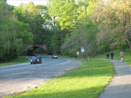
Drive, is a regular training site of the largest
running club in the area. One of the groups
of the Montgomery County Road Runners Club runs from there at 8:00AM, on Saturday and Sunday mornings. The runners of all abilities and levels take
to the Rock Creek Trail headed toward the D.C. border or headed in the other
direction toward Lake Needwood. So large is the running club that if you’re
on the trail at the same time as a training run, you might find yourself like
the protagonist in the movie Midnight Express, as he fought off madness in a
Turkish jail by purposefully heading in the wrong
direction. The hundreds of club
members who sometimes show-up are however much more fair, courteous and
pleasant with their trail-side manners.
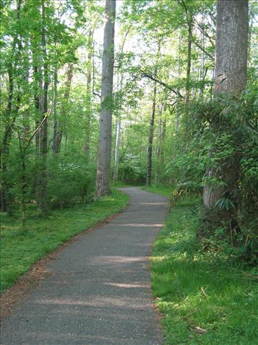
Take the trail at other times, and you will find quiet surroundings with
families cycling and walking through the many smaller parks that the trail
links together. Presumably, the name of
the starting area is derived from the names of the nearby towns of Kensington
and Garrett Park. The two towns are
separated by Rock Creek and the cliffs on the hillsides along it.
|
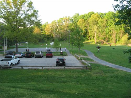
Above: The Ken-Gar
Palisades parking lot is small and crowded on weekend mornings.
Overflow parking is usually tolerated on the
shoulders of Beach
Dr.
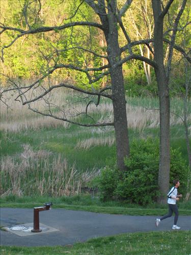
Right: A gift from
the Montgomery County Road Runners, several water fountains
(this one at Ken-Gar) are along the Rock Creek Trail
and work year round.
|
|
Getting
There
From
the Capital Beltway (I-495)
Take
Rockville Pike (Rte. 355) northbound to the first light. Turn right on the access road, the immediately
left onto Beach Dr. Just after Cedar
Ave. and after passing under the arched railroad
bridge 1 1/3 mile later, turn right into the Ken-Gar Palisades parking lot.
By
Metro Rail
The
Grosvenor metro rail station is approximately 1.7 miles from the Ken-Gar
Palisades parking lot. Exit from the
station, heading uphill on Tuckerman La.
Turn right on Rockville Pike.
Turn right again at the Strathmore Hall Arts Center. In front of the mansion, a paved footpath
leads downhill away from the mansion to Strathmore Ave. Cross Strathmore Ave, then turn right on it
to utilize the sidewalk. Where the
walkway runs-out, cross Strathmore Ave. again and descend to Rock Creek Park. Cross
Beach Drive, then turn left on the Rock Creek hiker-biker trail to the Ken-Gar
Palisades parking area.
Area
Routes
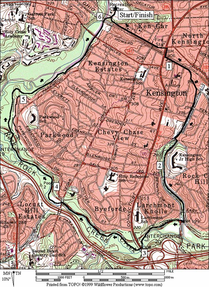
Kensington (6.1 miles, IV)
Kensington
is a mostly suburban area wrapped around by Rock Creek Park on its west and
south ends. From the Ken-Gar Palisades,
head toward D.C, then almost immediately turn left to climb toward Plyers Mill
Rd. Cross the busy Connecticut Ave at
the traffic light making your way past the antique shops in the downtown area. As quickly as it got busy, the level of
traffic slows again as you head down a long gentle grade toward Rock Creek park
along the Kensington Parkway. At the Rock Creek hiker-biker trail, turn
right following the trail very gradually uphill back to Ken-Gar Palisades. The Rock Creek trail along this part at first
stays near the creek itself and Beach Drive.
After crossing Cedar Lane, it veers away from the creek and the road for
a quiet section known to have good autumn color. Most of the trail from Kensington Parkway to
Ken-Gar Palisades is tree covered and flat.
Water is available along the Kensington Parkway
and at Cedar La. during
warm seasons.
|

|
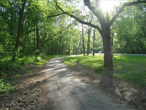
The Rock Creek Trail north of Connecticut Avenue.
|
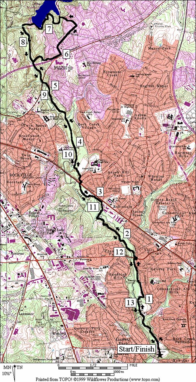
Lake Frank, South Shores
(13.85 miles, X)
This
lollipop route takes the Rock Creek trail out to one of the main tributaries of
the namesake creek. Passing through many
small parks and crossing a few major roads, the route climbs gradually and is
rolling until the loop portion. One hill
is encountered early on the way to Dewey Park.
Another larger one must be negotiated a half mile past the Randolph Rd.
intersection, after crossing over the Rock Creek. A small one is also on the way to Aspen Hill
park. The trail is mostly wooded with
several water and restroom stops. After Aspen
Hill Park,
it is increasingly rural in character though really surrounded by suburbs. While running it late in the day in the fall,
flashes of white continued to appear in the woods as the tails of herds of deer
dashed and crashed away from me. After
crossing under Norbeck Rd.
(Rte. 28), a spur trail climbs gradually at first along a small tributary. It gets increasingly steep until right at the
very end when you think it can’t get any tougher. The trail ends at the top suddenly on a
suburban street. A little over a mile
later, after passing through the Manor
Lake development, the waters of Lake
Frank become visible below. Turning left, follow the closed road around
the shores. It later becomes a paved
trail. At the dam, take a dirt trail
down a steep hill back to the Rock Creek trail, intersecting near where there
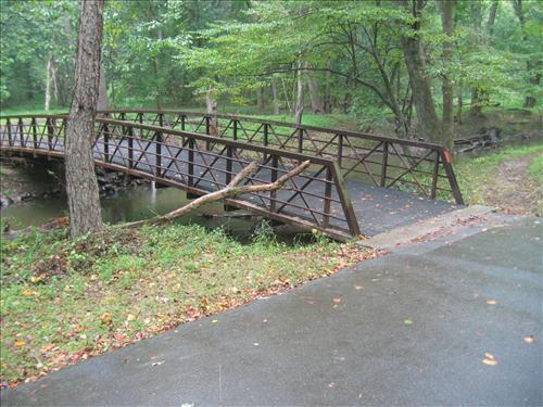
used to be a cable suspension bridge. The
bridge similar having been washed out several times by storms does not exist as
of 11/2006 but one similar to the one pictured below will get you across. Turn left on the trail and head back to
Ken-Gar Palisades. An alternate starting
point is from Aspen Hill
Park, which when starting from
there makes a 6.6 mile route.
|
|
One
of two bridges crossing Rock Creek north of Rte. 28 but below Avery
Rd. and Lake
Frank.
|
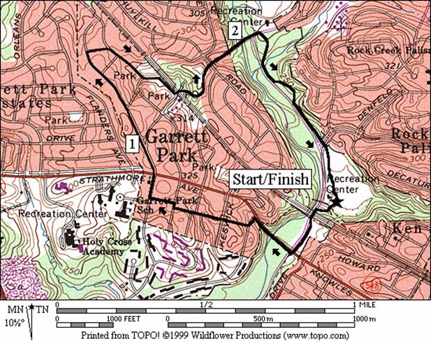
Garrett Park (2.7 miles,
III)
Garrett
Park is a kind of sleepy railroad town that had a city grow-up around it. Unlike other small towns around Washington
however, it retained its sense of identity and community. Many of the roads leading to and from it are
closed off to through auto traffic. Tall
mature trees bless the town with a cooling shade. The residents of Garrett Park gather and run
into each other as they pick-up their mail from the post office at the town
center. Mail is not delivered door to
door. About the only noise usually
heard, remarkable with it being right off of Rockville Pike and within walking
distance of White Flint Mall, are the diesel trains which pass by. The trains in-fact are somewhat responsible
for the towns existence. According to a
plaque near the town center, the town was laid out in 1889 by the Metropolitan
Investment and Building Co. and named after W. Garrett, once president of the
B. & O. Railroad.
The
route takes the Rock Creek trail to Cedar La., then follows a path along it up
and into the town limits. Once up the
initial hill, the course is mostly flat.
It passes by many older but well kept houses and also many newly
re-designed ones. Where sidewalks are
lacking, the route is in the streets. At
the small town center, turn left across the train tracks and down through
Schuykill Park. Garret
Park Rd. returns you to the Rock Creek Trail for
completion of the loop.
|
|
The Rock Creek Trail between Ken-Gar and Mile Marker
5. The bridge is the railroad
Beach Drive overpass.
|
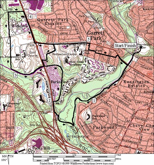
Tuckerman Lane (5.9
or 4.4 miles, VI or IV)
Head
south on the Rock Creek Trail to where it separates, then merges again with Beach
Dr. Turn
right, up Beach Drive and
then very briefly go along Rockville Pike to Tukerman
Lane. Climb
the hill up Tuckerman Lane
past the Grosvenor metro station. The
short route breaks off here to pass through the grounds of the Strathmore
Hall Arts Center. A few modern sculptures grace the Center’s
lawn, distracting the eyes and teasing the mind. Otherwise, the longer route crosses Rockville
Pike. A commuter convenient hiker-biker
trail head on the right side of the road is located across from the Marriott
Brighton Gardens
and Nursing Assisted Living facility, before Kings
Riding Way.
The trail skirts along the borders of the grassy Georgetown Prep campus
and golf course and is bordered on the other side by town homes. At the trail end, begin a long down hill
section by turning right to get to Rockville Pike, then right again once on Rockville
Pike. After turning left onto Strathmore
Ave, the short route joins in. Some unavoidable parts of Strathmore
Ave are unpleasant for foot or bicycle traffic due
to a lack of a sidewalk in some places.
Proceed through Garrett Park on side streets back to the Rock Creek
trail, then back to the Ken‑Gar Palisades
Nearby
and Connecting Zones
Bethesda
Rock Creek Park, District of Columbia/Maryland
Border
Rock Creek Park, Aspen Hill
Rock Creek Park, Lake Needwood
Cabin John Regional Park
What
to do Afterward
Food
and Drink
Panera
Bread - (301) 881-5515
The
Garrett Park Café - 301 929-0486
Lebanese
Taverna Café - 301 468-9086
Bagel
City - 301 231-8080
The
Cactus Grill - 301 460-2928
Entertainment
and Edification
Strathmore
Arts Center Gallery (Saturday 10AM-3PM,
closed Sunday) 301 530-0540
Strathmore
Hall Music in the Mansion 301 530-0540
Kensington
Distance: 6.1 miles
Rating: IV; paved trails, roads and a short
section of an unpaved trail, mostly graded hills
R 0.0 on
the Rock Creek trail (south) from the parking lot at Ken-Gar
L 0.05 paved
trail to Plyers Mill Rd
S 0.2 Plyers
Mill Rd
CR 0.6 Connecticut Ave
L 0.65 Howard
Av
L 0.95 Kensington Pkwy
(water at 1.75)
L/R 1.8 L on
Littledale Rd; R onto
unpaved trail after crossing the creek
2.15 trail
becomes paved after crossing Saul Rd
R 2.55 Rock
Creek Trail at Beach Dr
2.85 cross
Beach Dr
BL 2.9 trail
X; before Connecticut Ave
3.0 Connecticut
Ave underpass
3.2 trail
X; merges from R, from Connecticut Ave
3.8 Cedar Ln (water)
L/R 4.6 to
cross Beach Dr
L 5.45 to
stay on the Rock Creek Trail 0.25 miles past mile marker 6
R 5.85 Knowles Ave
5.95 railroad
underpass
6.05 trail
X on R to Plyers Mill Rd
L 6.1 Ken-Gar
parking
L 0.0 north
from the parking lot
0.65 Garrett Rd; Viers
Mill Park
(restrooms, phone)
L/R 1.3 leaving
Dewy Park
after water to stay on Rock Creek Trail
R/L 1.65 Randolph
Rd; to stay on trail
L/R 2.0 at water
fountain to cross Rock Cr and stay on trail (unmarked)
3.1 Park
Lawn Cemetery road
3.4 cross
Viers Mill Rd to Aspen
Hill Rd
L 3.45 Adrian
St; to stay on trail
CR 3.5 Baltic
Ave; to stay on trail
L 3.55 Aspen
Hill Park; trail head on L at 3.65 (water, portable restroom)
4.6 trail
X on L to bridge over Rock Cr
5.15 Baltimore Rd
5.45 underpass
Norbeck Rd (Rte 28)
(unmarked)
R 5.5 trail
X (unmarked, paved) to Norbeck Rd
S 5.8 trail
ends at Norbeck Rd
CL 6.0 Bauer Dr
L 6.55 Trailway Dr
L 6.85 at
T; old park road (closed to autos)
7.0 sharp
bend in road to the R
7.15 paved
trail head at end of old parking
L 7.6 trail
X; unpaved trail at top of dam (! unmarked, down steep hill)
R 7.7 before
suspension bridge (if used, subtract 0.08 miles)
L 7.75 Rock
Cr Trail (paved, unmarked) near mile marker 13
7.8 suspension
bridge on L
8.35 trail
X on L(unmarked) to Norbeck Rd
8.4 underpass
Norbeck Rd (Rte 28)
8.7 Baltimore Rd
9.25 trail
X on R to bridge over Rock Cr
10.25 Aspen
Hill Park;
trail head (water, portable restroom)
R 10.3 Baltic
Ave; to stay on trail
CL 10.4 Adrian
St; to stay on trail
CR 10.45 Aspen
Hill Rd; cross Viers Mill to trail head
10.75 Park
Lawn Cemetery road
L/R 11.8 cross
Rock Cr to water fountain
R/L12.2 Randolph Rd; to
stay on trail
L/R 12.6 in
Dewey Park to stay on trail (water)
13.2 Garrett
Rd; Viers Mill
Park (restrooms, phone)
R 13.85 Ken-Gar
Palisades parking
Garrett Park
Distance: 2.7 miles
Rating: III; paved trails with some sidewalks
and light traffic roads
R 0.0 on
the Rock Creek trail (south) from the parking lot at Ken-Gar Palisades
0.05 paved trail to Plyers
Mill Rd on L
0.15 railroad
underpass
CR 0.25 paved
trail along Knowles Ave
L 0.45 Weymouth St
R 0.5 Oxford St
R/L 0.75 at
Montrose Av to stay on Oxford St
CR 0.8 Kenilworth Ave
0.9 Strathmore
Av (!)
BL 1.0 to
stay on Kenilworth Ave
R 1.4 Clyde Ave
R 1.45 Rokeby Ave
L 1.6 Argyle
L 1.75 cross
the railroad tracks at the town center; downhill into Schuykill
Park
S 1.9 on
L side of Garrett Rd
R 2.05 Rock
Creek hiker-biker trail
2.55 Wexford Rd
R 2.7 Ken-Gar
Palisades parking
Tuckerman Road
Distance: 5.9 or 4.4 miles
Rating: VI or IV; mostly paved trails with
some sidewalks and street shoulders
5.9
Mile Route
R 0.0 on
the Rock Creek trail (south) from the parking lot at Ken-Gar
0.05 paved trail to Plyers
Mill Rd on L
0.25 Knowles Ave
R 0.65 at
T to stay on Rock Cr Trail
R 1.5 Beach
Dr (protected shoulder)
CL 1.8 toward
Rockville Pike
R 1.85 Rockville
Pike (gravel path)
R 2.0 Tuckerman
Rd (sidewalk)
<*
2.6 Rockville
Pike
R 3.05 paved
trail before Kings Riding Way
and across the street from Brighton Gardens Nursing Assisted Living
L/R 3.45 corner
of Georgetown Prep grounds
R 3.75 Edson
La at Woodglen Dr
R 3.95 Rockville
Pike
CL 4.33 Srathmore
Rd (! narrow shoulder)
4.55 trail
to Strathmore Hall on R
>*
R 5.0 Kenilworth Ave
L 5.1 Oxford St
R/L 5.15 at
Montrose to stay on Oxford St
L 5.4 Weymouth St
R 5.45 trail
toward Rock Creek
CL 5.65 Beach
Dr; Rock Creek hiker-biker trail
5.75 railroad
underpass
5.85 paved
trail on R to Plyers Mill Rd
L 5.9 Ken-Gar
Palisades parking

*4.4
Mile Route
R 2.6 Rockville
Pike
R 2.7 Strathmore
Hall parking
L 2.8 trail
head in front of mansion
3.05 Strathmore
Ave on shoulder (!) (pickup cues after 0.4 miles at mile 5.0 on 5.9 mile route)