|
|
Getting There
From the Capital Beltway (I-495), take either of the I-70 spurs north. Approximately 4 miles west of the merge, turn right (east) on Rte. 28 (Montgomery Ave), into Rockville. Follow the signs for Rte. 28 through the city. After crossing Viers Mill Rd., approximately 2 miles from I‑70, turn left onto Norbeck Rd. to stay on Rte. 28. After 1.3 miles on Norbeck Rd., turn left onto Avery Rd. After 1.9 miles, turn left into Lake Needwood Park. At the T intersection 0.3 miles later turn left. After 0.15 miles, the road becomes one-way and you must turn right. Pass by the lake shore and after 0.3 miles turn right into the parking lot leading toward the open field. The Rock Creek hiker-biker trail head is located at the end of the parking lot.
Area
Routes
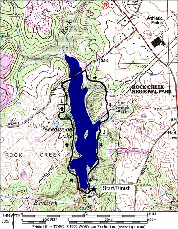
Lake Needwood Loop (2.5 miles, II)
To
get around Lake Needwood, it is necessary to use some
roads and several unmarked and unpaved trails.
The land surrounding the lake is hilly but most of the hills are avoided
by this route. Start at the end of the
parking lot at the trail head of the Rock Creek hiker-biker trail. Head toward the lake, then
bear left on the gravel road that crosses the field diagonally and goes up the
hill. The hill is actually the lake’s
dam. Follow the road across the dam and
beyond as it rolls gently through the woods and crosses two pipeline
clearings. Several side trails are
visible but the route continues straight.
At one point you will follow a bend left and away from the lake to a T‑intersection. Turn right at the intersection
, then right again on a grassy trail back toward the lake. As you near
This
hilly route offers an abundance of good views and unpaved trail running. Leaving
After
the stone crossing, continue downstream along the edges of the North
Branch. Though you’re still on the lake
shore, the trail is now the called the Sleepy Hollow Trail (marked “SH”). It passes through the splendid rock formations,
visible earlier from the other bank as part of the picturesque view. Further ahead, after crossing a wooden bridge
to a T intersection, think counter-intuitively and turn right, away from the
lake, continuing up a hill. This is
still the Sleepy Hollow Trail. Turn left
at the next intersection however, onto the Big Pines Trail (marked “BP”). The trail really gets hilly from this point,
for most of the way back to
At
the secondary parking lot, continue straight to and across
Nearby
and Connecting Zones
Rock Creek Park, Ken-Gar Palisades
Seneca Creek State Park, Lake Clopper
What to do Afterward
Food
and Drink
Samwoo Restaurant - Korean and Japanese Cuisine - 301 424-0495 or 301 294-9266
Olney Ale House - vegetarian and contemporary meals - 301 774-6708
Soup’s On - (301) 340‑7766
Entertainment
and Edification
Needwood
Distance: 2.5 miles
Rating: II; unpaved trails, roads with some small hills
R 0.0 from the Rock Creek trail head; toward the lake
L 0.0 gravel road that crosses the field diagonally and goes up to the dam
0.5 pipeline clearing
0.65 second pipeline clearing
BL 0.8 follow the main trail left, away from the lake
R 0.9 at a T; the trail is grassy
R 0.9 trail X on R
BL 1.0 trail from the R merges near the lake
R 1.2 down the steps on the R toward the road
R 1.2 Needwood Rd (unmarked) along the lake
R 1.4 Beach Dr (unmarked) into the park
R 1.95 leave the road after passing a wooden bridge on the R; go toward a shoreline trail
BL 2.35 trail X on L before the boat rental building to skip the peninsula; continue along the lake’s shore
2.5 complete the loop to where the gravel road leaves the parking lot
2.5 Rock Creek Trail head at the parking lot
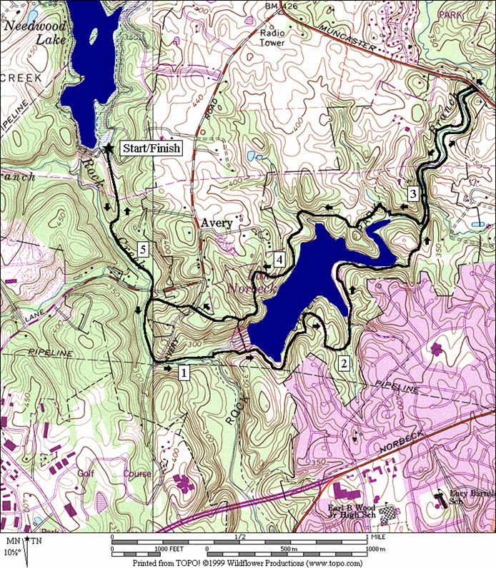
Distance: 5.45 or 6.6 miles
Rating: VII or VIII; paved and unpaved trails; some steep hills on the last half of the route
L 0.0 south from the parking lot on the Rock Creek hiker-biker trail
0.65 Southlawn La
0.7 trail X on L unpaved (return route)
S 1.15 onto unpaved trail just before mile mark 13, where the trail turns R to cross Rock Creek
L 1.2 trail X on L; suspension bridge on R
BR 1.25 at fork in trail to go up to the dam
R 1.35 Lakside Trail (LS) (paved)
S 1.8 trail ends at old parking lot
1.95 sharp bend in road to L
BL 2.25 into old parking lot before road ends
S 2.35 Lakeside Trail continues (LS)
2.9 cross small stream on stones
2.9 Sunfish Trail on R (SF)
<*
L 3.0 trail X on L crosses North Branch Rock Creek on stones (! slippery)
>*
L 3.0 Sleepy Hollow Trail (SH) after crossing creek
R 3.35 at T after crossing a wooden bridge to continue on Sleepy Hollow Trail
L 3.4 Big Pines Trail (BP); R to N Center
BL 3.55
3.65 Old Nasty Trail (ON) on R
R 4.35 at fork to paved trail
BR 4.35 paved trail; further up steep hill
S 4.5 trail ends at parking lot
S 4.55 trail
head across
R 4.75 Rock Cr Trail (paved, unmarked)
4.8 Southlawn La
5.45 trail
ends at
![]()
3.0 trail X on L crosses creek
BR 3.2 to stay on trail (follow blazes); L fork is a dead end
L
L 3.55 Muncaster Mill Trail (MM) (unmarked) after crossing creek
BL 3.85 to stay on MM at stairs on R
S 4.1 MM
trail becomes Sleepy Hollow Trail (SH) at stairs on R; R is to
S 4.15 trail X on L crosses creek; (pickup at mile 3.35 on 5.45 mile route)