Seneca Creek State Park, Lake Clopper
Lake
Clopper
in Gaithersburg is a refreshing
place to exercise, picnic, or just take in the views. A nominal entrance fee is required but what
you get for it is a park that=s
not very crowded, and one that has plenty of places to explore. Begin by checking-out its namesake lake. A dirt loop trail open to mountain bikes,
when it=s not
wet, circles the lake staying close to the water almost the whole way. Other trails go in and out of various stream
valleys. The Lake
Clopper Visitor
Center is at one end of the new
Greenway Trail. All but a small section
of it near a construction zone at Rte. 28 has been completed as of June,
1999. The Greenway Trail can be
followed approximately 14 miles to Riley=s
Lock on the C&O Canal. It connects several existing trails. It was created through the joint efforts of
the Maryland State
Forest and Park Service and the
Friends of Seneca Creek State Park, a volunteer non-profit organization (301
924-2127). Cycling is not allowed on it except for a small portion within Lake
Clopper Park.
Getting
There
From
the Capital Beltway (I-495), take I-270 headed west. About 10 miles from the beltway, take Exit
10, Clopper Road
headed west. Turn left 2 miles later
into the park. Pay the entrance fee
(annual and life passes are available).
Bear right onto Seneca Creek Road. After half a mile, turn left into the
Kingfisher Overlook parking area.
Area
Routes
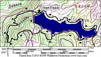
Lake Shore Trail (3.45 or 4.6 miles, II or IV)
Lake
Clopper
was created by damming the Long Draught Branch.
The loop starts with great views across the length of the lake. Kingfisher Overlook parking is at a vantage
above the dam. The loop can be
considered flat, but you will at first descend gradually toward the boat center
as you go clockwise. After the boat
center, the trail hugs the shoreline, mostly following the lake=s fingers. Parts of the trail, on the way to the far end
of the lake, are unevenly sloped and have exposed tree roots. Care is necessary to avoid falling. Some side trails separate from the main loop
and come back again. Follow the blue
blazes. After rounding to the other side
and coming most of the way back, the Mink Hollow Trail (white blazes) offers an
option to extend the loop. While
hillier, this trail has better footing and is fun to run as it twists up,
around and down to the Long Draught Trail.
Just before hitting the Long Draught Trail, the Mink Hollow Trail passes
over a small boardwalk through a wetland.
The Long Draught Trail climbs the stream valley back to the dam and the
Lake Shore Trail. This loop, including
the optional extension is open for mountain biking, but may be closed when
conditions are damp.
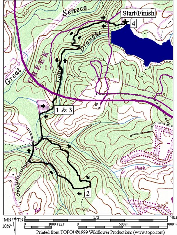
Long Draught Trail (4 miles, IV)
From
the Kingfisher Overlook parking lot, go west (not on the Lake Shore Trail) to
the car turn- around circle and follow the dirt trail downhill to the road at
an intersection. Cross the road and
continue downhill on the left side of the intersecting road (on the opposite
side). This is the Long Draught Trail
(blazed yellow) and is also the Greenway Trail.
The trail switchbacks down to a pleasant tree covered but open stream
valley. Intersect the Mink Hollow Trail
which shares the same path for a short way, but keeps going on, under the Great
Seneca Highway.
After the highway, pass wetlands on the right. They mark the confluence of the Long Draught
Branch and the Great Seneca Creek. The
trail passes a wooden observation tower on the right side, then
follows a gravel road. Turning left
before the end of the road, separate from the Greenway Trail on the loop
portion of the Long Draught Trail. Climb
gently at first, then very steeply up a hillside with many ferns and mountain
laurel. Cross a dirt road in the middle
of a power line clearing, climb a little more, then
begin a descent to another stream valley.
At Riffleford Rd, loop to the right, where two
valley=s and
trails merge. Pick-up
the gravel road and Long Draught/Greenway Trail for the return. This loop is open to mountain bikes, weather
conditions permitting.
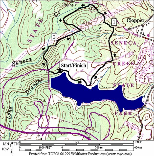
Great Seneca Trail (2.55 miles, III)
|
|
To
make this route a loop, follow the Lake Shore Trail to just past the boat
center. Before the trail goes downhill
and enters back into the woods, turn left, uphill on the boat center
road. At a T intersection, cross to
the other side continuing uphill on a grassy trail identified by a small
wooden bridge and a sign. This is a
spur portion of the Lake Shore Trail and is blazed blue. At the next T intersection at Seneca
Creek Rd., go right and left to continue the
climb toward the Visitor Center. Once there, take the orange blazed Great
Seneca Trail back down. The beginning
of this trail is also the trail head for the Greenway Trail. It crosses field clearings for power lines
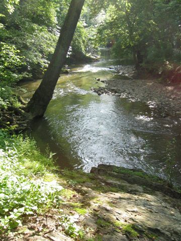
and pipelines before bottoming out at the very picturesque Great Seneca
Creek. Springtime flowers bloom
abundantly among the rocks and partially wooded valley there. The creek is deep and wide. Follow it downstream for a way, then climb out of the valley back into the power line
clearing. Going to the right, the
trail rolls and climbs more before descending steeply back to Great Seneca
Creek. After a short stretch along the
banks, it once again climbs steeply to return you near the Lake
Clopper
dam, and the Kingfisher Overlook. The Great Seneca Trail is not open to
cyclists.
|
Nearby
and Connecting Zones
Seneca State Park, Black Rock Mill
Seneca State Park, Schaeffer Farm
Rock Creek Park, Lake Needwood
What
to do Afterward
Food
and Drink
Earnies Restaurant and Pub - 301 869-8200
Bagels
DeLox - 301 216-0070
Spring
Mill Bread Co. - 301 977-7733
Entertainment
and Edification
Agricultural
History Farm
Park - 301‑948‑5053
Montgomery
County Fairgrounds - 301 963-3247
Lake Shore Trail
Distance: 3.45 or 4.6 miles
Rating: II or IV; dirt trails through
wooded lakeside trails
3.45
Mile Route
0.0 toward
the lake from the bulletin board at the east end of the lot
L 0.0 Lake
Shore Trail (blue blazes)
0.45 parking
circle at boat center
BR 0.5 trail
goes down into woods as road bends L to go uphill
L 0.8 at
the trail X and wooden bridge to stay on the Lake Shore Trail; follow blue
blazes
1.3 gravel
road X
BR 1.6 at
trail X on L toward Long Draught Rd to stay on Lake Shore Trail (end of lake;
begin to loop back)
BR 1.65 Long
Draught Branch (stream pipe); BR afterward to stay on Lake Shore Trail
1.85 closed
road on L
>*
2.8 Mink
Hollow Trail on L (white blazes)
BR 3.05 trail
X on L to stay on the Lake Shore Trail; follow blazes
3.1 lake
overflow spillway field
BR 3.2 on
gravel trail at dam and Seneca Creek Rd
(unmarked)
R 3.3 at
break in fence to leave dam; uphill
3.35 trail
X on L to west end of Kingfisher Overlook parking
L 3.45 trail
X on L to bulleting board (east end); Kingfisher Overlook parking

*4.6
Mile Route
L 2.8 Mink
Hollow Trail (white blazes) goes uphill
3.2 cross
Seneca Creek Rd
R 3.75 Long
Draught (yellow blaze) and Greenway Trail at T after marsh bridge
3.9 Mink
Hollow Trail goes L
4.5 Seneca
Creek Rd
4.55 turnaround
circle at Kingfisher Overlook parking
4.6 bulletin
board (east end); Kingfisher Overlook parking
Long Draught Trail
Distance: 4.0 miles
Rating: IV; dirt trails through stream valley
woods with some steep hills
4.0
Mile Route
0.0 head
west across the parking lot from the bulletin board at the east end of parking
0.05 gravel
trail head at Kingfisher Overlook parking turn-around circle
BL 0.1 cross
Seneca Creek Rd to pickup the Long Draught Trail head (yellow blazes) and the
Greenway Trail on the L side of the intersecting road
0.7 Mink
Hollow Trail (white blazes) joins from R; follow yellow/white blazes S
0.85 Mink
Hollow Trail goes L on a wooden bridge; continue S following teal/green blazes
for Greenway/Long Draught Trails
0.95 underpass
Great Seneca Highway
1.05 observation
platform for wetland
1.15 trail
continues by bearing L on gravel road
L 1.3 loop
portion of Long Draught Trail (steep hill and yellow blazes); Greenway and Long
Draught return is S
1.75 dirt
road in power line clearing
1.95 trail
X on L to McDonald Chapel Dr (unmarked)
R 2.5 Riffleford Rd (use shoulder)
R 2.6 gravel
road on R (Greenway Trail, Teal/Green blazes) before creek bridge; passes
utility building ahead
2.7 complete
Long Draught Trail loop at trail X on R (same as mile 1.3)
2.85 trail
bears R at wetland and end of gravel road
2.95 observation
platform for wetland
3.05 underpass
Great Seneca Highway
3.15 Mink
Hollow Trail (white blaze) joins from the R from the wooden bridge; follow
white and yellows blazes S
3.3 Mink
Hollow Trail goes L; follow yellow blazes S
3.9 cross
Seneca Creek Rd at road X to gravel trail
3.95 gravel
trail at Kingfisher Overlook turn-around circle
4.0 bulletin
board at east end of Kingfisher Overlook parking
Great Seneca Trail
Distance: 2.55 miles
Rating: III; dirt trails and park roads with
some steep hills
2.55
Mile Route
0.0 toward
the lake from the bulletin board at the east end of the lot
L 0.0 Lake
Shore Trail (blue blazes)
0.45 parking
circle at boat center
BL 0.5 on
road going uphill as Lake Shore Trail goes down into woods
S 0.55 Rd
X at T; Lake Shore Trail spur goes uphill over small wooden bridge on a grassy
trail (blue blaze)
R/L 0.7 at
Seneca Creek Rd; continue uphill toward park exit
0.9 entrance
gatehouse
L 1.0 2nd
road on L toward Visitor Center Parking
R 1.1 Great
Seneca Trail (orange blazes) and Greenway Trail head
1.15 power
lines clearing
L 1.3 at
T at Great Seneca Creek; bottom of hill after gas pipeline
1.8 Old
Pond Trail on L and wooden bridges in power lines clearing
1.9 trail
X on L to Chickadee parking
2.05 trail
leaves power line clearing
BR 2.2 at
trail X on L; follow orange blazes down to Great Seneca Creek
BL 2.3 at
trail X on R; leave the creek and follow orange blazes up the steep hill
S 2.45 end
of Great Seneca Trail; cross Seneca Creek Rd at intersection on R to the gravel
trail going uphill into the woods
2.5 gravel
trail ends at Kingfisher Overlook turn-around circle
2.55 bulletin
board at east end of Kingfisher Overlook parking