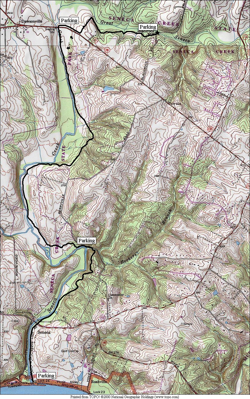
Seneca Creek State Park, Black Rock Mill
Situated
in the middle of Seneca State
Park and the middle of the Greenway Trail, Black
Rock Mill is a good place to start exploring.
Unlike the northern end of the park and the trail, there are hardly any developed
amenities for many miles in either direction of Black Rock Mill. Lake
Clopper is over 5 miles north. The Visitor
Center there is 6.2 miles
distant. The C&O
Canal, in the other direction, is
7.2 miles south. Other than bridges, and
a few road crossings, there’s not much else made by man in-between. Running or hiking the trail definitely gives
you a feeling of being out in the country.
Neither suburban developments nor rural housing are yet visible from most
of the sections of the trail described here. Few people frequent the area
mostly because the Greenway trail is new but also because of the long
out-and-back distances. Don’t let that
stop you. Just turn around at a distance
comfortable for you and you’ll have a nice run.
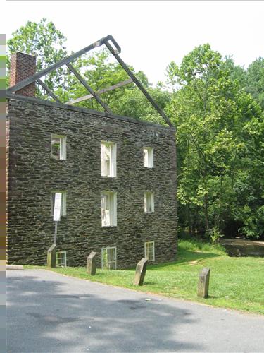
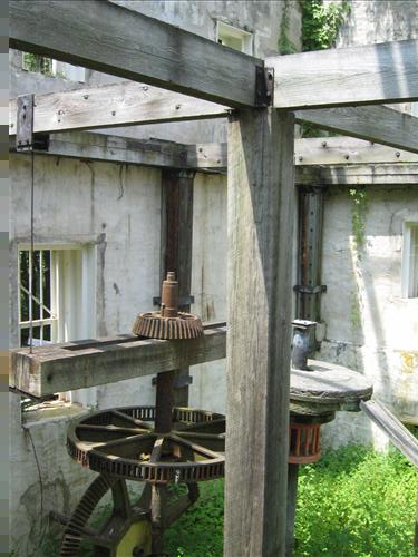
The
namesake mill is located right off Black Rock Rd. west
of Darnestown.
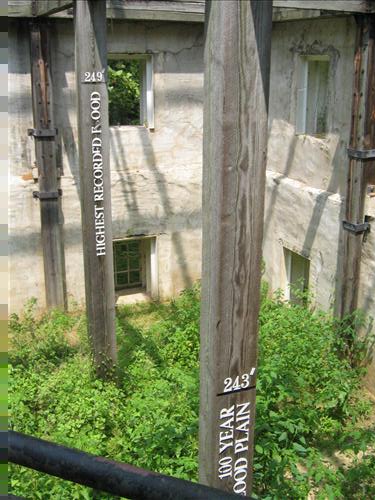
The site is one of Montgomery County’s
nicer outdoor exhibits. Inside the walls
of the now roofless old building, displays tell the history and some of the
mill’s gearing machinery is preserved hanging, giving a sort of cut-away view
of a milling operation. A steady supply
of water used to be supplied by a dam that was located 200 ft. upsteam. The dam no
longer exists and the startling high water marks on the inside of the walls
show the magnitude of the floods that came over the last century.
Rolling
tree covered hills surround the banks of the Great Seneca Creek from the mill,
northeast and southward. As of 2005, The
Greenway Trail goes from Damascus Recreation
Park to the C&O
Canal and will one day bridge the Potomac
and Patuxent rivers.
An additional access to areas south of Black Rock Mill can be gained by
parking near the bridge at Darnestown
Rd., Rte. 28.
The trail northeast of here is described in the route description below.
Going south from Black
Rock Mill on the Greenway Trail it is 1.1 miles to Rte. 28 and is a little
hilly. After ups and downs in the woods,
it crosses along the edge of a farm field where large herds of deer can be
seen. Beyond Rte. 28, the next four-and-a half miles are fairly flat, mostly
shaded and very runnable until reaching Berryville Rd. Between Berryville
Rd. and the Seneca Rd.,
the next 1.4 miles begins with a tributary creek crossing and an initial steep
hill that is followed by successively easier ones. A final flat straight stretch of 0.75 miles
on the road leads to the C&O Canal
and Potomac River at Riley’s Lock and the mouth of the
Great Seneca Creek.
An
area close to the Black Rock Mill is the Schaeffer Farm section of Seneca
State Park. It is just north of the mill and a favorite
of mountainbike cyclists. The White Trail there can be reached by going
up a steep hill on Black Rock Rd. and turning left only a half mile distant. See Seneca State Park,
Schaeffer Farm for routes there.
Getting
There
From
the Capital Beltway (I-495), take I-270 headed west. Stay in the right lanes. About 5 miles from the beltway, take Exit 6, Darnestown Rd., Rte. 28 headed
west. Follow the signs bearing right at
the light onto Key West Ave.
to stay on Rte. 28 where Darnestown
Rd. bears left.
Rte. 28 road has been rerouted. Key
West Ave. later joins and becomes Darnestown Rd. again. Turn
right 9.6 miles from the beltway on the easy to miss
Black Rock Rd.
It’s only 0.3 miles past Berrville Rd. on the
left. The mill parking is 0.6 miles from
Rte. 28 near the bottom of the hill on the left side of the road.
Area
Routes
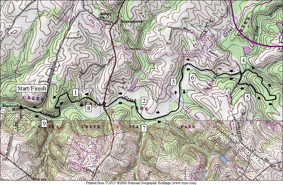
To Riffleford
Rd. and Back (9.25 miles, X)
If
you want to see a lot of the Great Seneca Creek, this route offers the longest
stretches in which it is visible from the Greenway Trail. The dirt single-track is broken up by a few
road crossings allowing for measurable, early turnaround points. The full trip uses the loop portion of the
Long Draught Trail (see Seneca State
Park, Lake
Clopper). Hikers will immediately recognize the first
portion near Black Rock Mill to be more like places found in the Shenandoah
National Park. The heavy forest growth keeps it cooler in
hot weather, and there are some rocky areas in the creek and on the hills. Many good fishing holes are passed
early. Two major hills are hit early on
also. The first is long but the second
is not. After crossing Rte. 118, the
trail becomes easier as it flattens through some fields and aligns itself again
with the creek. Some areas of tall grass
may pose an obstacle however. I
encountered grasses on the sides of the trail 6 and 7 ft. tall in two
places. Ahead I ran into a ranger and a
volunteer who coincidentally were mowing it, coming from the other direction
(call Friends of Seneca Creek State Park at 301 924-2127 if you wish to
contribute or participate; volunteers were key to creating this local
gem). Ticks in summer are a problem so
if you find the same tall grasses, be sure to check
yourself thoroughly to avoid Lyme disease. On a warm day, I pulled off more ticks on a
round trip than I have fingers to count on.
Another thing that may unsettle some is the sound of gunfire. Local gun clubs target practice on the
opposite banks of the creek. The sound
can be heard for miles. There are deer
on that side that didn’t look too happy about it. The trail is beautiful however and well worth
exploring. Several wooden bridges make
getting across gullies and side streams easy.
A few old trees with trunks of 6 ft. in diameter can be seen. Great Blue Heron and other birds
fish or bath in the waters. Several
portions of the trail are on top of old dykes.
The turn around on the Long Draught Trail’s loop, actually past Riffleford Rd., includes the
only other hill of the course. Cycling
is only allowed on the Long Draught Trail portion of this route.
Nearby
and Connecting Zones
Seneca State Park, Schaeffer Farm
Seneca State Park, Lake Clopper
C&O Canal, Riley’s Lock
What
to do Afterward
Food
and Drink
Hogi Yogi - 301 527-1495
Pastalicious - 301 208-1430
Fudruckers - 301 869-6010
Entertainment
and Edification
C&O
Canal, Riley’s Lock
L 0.0 Black Rock Mill Rd
from parking
R 0.05 Greenway
Trail (teal blazes)
0.2 trail
X on L at wooden bridge goes to Black Rock Mill Rd
BL 0.5 leave
creek and climb following blazes; S is a fishing trail that dead ends
R 0.9 at
T to stay on Greenway Trail
L 1.0 trail
X on L to wooden bridge to stay on trail; S is fishing trail; follow blazes
1.45 Rte
118
2.7 begin
power line clearing
R 3.9 on
gravel road
R 3.9 Riffleford Rd to cross Great
Seneca Creek (!)
L 3.95 gravel
road for utility bldg
R 4.0 Long
Draught Trail (yellow blazes) on R after gate; up steep hill
4.5 dirt
road in power line clearing
4.7 trail
X on L to McDonald Chapel Dr
(unmarked)
R 5.25 Riffleford Rd (use shoulder)
XS 5.3 gravel
road on R (Greenway Trail) completes loop before creek bridge
L 5.35 dirt
road after crossing creek
L 5.35 trail
X on L to continue on Greenway Trail; follow teal blazes
6.55 end
power line clearing
7.8 Rte.
118
R 8.25 at
T after wooden bridge to stay on Greenway Trail; L is fishing trail
L 8.35 at
trail X on L to stay on Greenway Trail; follow teal blaze
BR 8.75 at
bottom of hill at creek to stay on Greenway Trail
9.05 trail
X on R at wooden bridge goes to Black Rock Mill Rd
L 9.2 Black Rock Mill Rd
R 9.25 Black
Rock Mill parking