Seneca Creek State Park, Schaeffer Farm
North
and only a half mile from the Black Rock Mill is the Schaeffer Farm Trail
System. As part of the Seneca
Creek State Park,
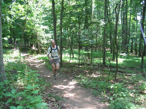
the area is a hiking, horseback and cycling haven. Cyclists however, are the people you’ll see
most often here. The unpaved trails
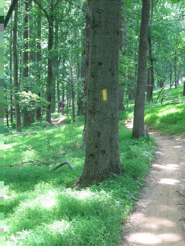
braid through trees, go along the edges and pass right through the middles of
the fields. Volunteers who created them
designed them with cycling in-mind and designed them to be environmentally
friendly. Most are not too technically
demanding for the cyclists which means they are pretty
good for runners. It is open during
daylight only and off-trail use of the area is restricted.
Schaeffer Farm Video
Getting
There
From
the Capital Beltway (I-495), take I-270 headed west. About 10 miles from the beltway, take Exit
10, Clopper Road (Rte. 117)
headed west. Turn left after 4.25 miles
on Schaeffer Rd which is
just past the intersection with Rte. 118.
Just under 2 miles later, as the road bends right,
bear left onto a gravel road where there are signs for Schaeffer Farm Trails
and the Grey Rock Ranch. Quickly turn
left again following the bumpy road to the end and park. The trail head is at
the very end of the parking area.
Area
Routes
Schaeffer Farm White Trail
(3.4 miles, III)
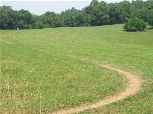
The
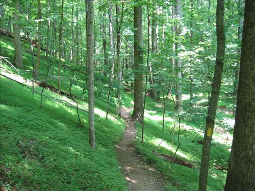
White Trail is a nice introduction to the area and makes a clean loop that=s easy to follow. What you=ll find are mellow trails through the woods and field edges
that roll through small stream valleys.
As you near and then parallel Black
Rock Rd., you gently climb out of one stream
valley and start to drop into another.
Plenty of deer hang around there in the mornings and late in the
day. When crossing a gravel road, you
can optionally check-out the Black Rock Mill by turning left and right, and
going down the steep hill. Continuing
down the White Trail, fly down the curvy roller coaster trail until you hit a
telecommunications cable line clearing.
This continues downhill more and makes a big dip before making a double
stream crossing over stones. After that
a sharp initial climb gives way to gradually flatter trail until you reach the
start.
Schaeffer Farm
Western Trails (7.65 or 6.25 or 8.65 miles, VII or VI or VIII)
The
western portion of the Schaeffer Farm area is crisscrossed with several
trails. The Yellow Trail is the main
one, the most interesting and the longest.
The Blue Trail creates many shortcuts for the tired and is mostly in the
open fields through sometimes beautiful rolling hills. The Red Trail makes an extension off the
Yellow Trail.
When
the Yellow Trail breaks off from the White Trail it rambles, dropping through
the woods toward Great Seneca Creek and climbing back again, to the fields two
times. In this meander it crosses small
streams and gullies but does not get close enough to the Great Seneca Creek for
a view of it. Fallen trees on the trail
in this first part generally appear not to be cleared from the trail. Instead they are used as obstacles for the
mountain bikers. Some of these have been
stacked 3 ft. high like horse jumps for the extreme and the accomplished to
test their skills and tap into their adrenaline. Misjudgements and
chain rings eventually saw other small trunks in half.
A
crossroads of sorts, one of many for Yellow/Blue trail intersections, marks the
beginning of the loop portion of the Yellow Trail. Some of this loop is wooded but more of it is
along the edges of farmed fields. It=s also flatter than parts of the Yellow
Trail not on the loop. Mountains are
visible on the horizon. The Red Trail
extension is a lollipop route off the Yellow loop. It goes through grassy fields and has one
short steep drop to a stream crossing on the out and back leg. Different connected segments of the Blue Trail
act as spoke wheels inside the Yellow loop to shorten it. While coming back, the Yellow Trail does get
close enough to the Little Seneca Creek for brief views. Before coming back to the crossroads where
the loop portion began, the trail crosses and climbs more rolling fields. When the hay has been bailed into giant
cinnamon rolls there, the fine agrarian landscape provides a feast for your
eyes. Take the Blue Trail back through
more of the meal and dessert on the final winding parts through the woods back
to the parking area.
Note
that no water or other amenities are available on any of the trails. Plan accordingly. Trails are generally well traveled on
weekends by cyclists and occasional horseback riders who might help you if you
get lost. Trail blazes and markers are
well placed in the woods but not always at trail intersections in the
fields. More than a few cyclists
commented on being disoriented but by plowing ahead, knew they would get
where they were going. If you have one,
a compass or hand-held GPS could be useful on a first trip. Signs are provided at some
intersections with arrows and a AP@ to designate the shortest way
back.
Nearby
and Connecting Zones
Seneca State Park, Black Rock Mill
Seneca State Park, Lake Clopper
Black Hill Regional Park
What
to do Afterward
Food
and Drink
Picnic
Earnies Restaurant and Pub - 301 869-8200
Bagels
DeLox - 301 216-0070
Entertainment
and Edification
Black
Rock Mill - interpretive exhibits
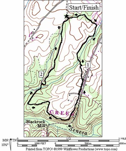
Schaeffer Farm White Trail
Distance: 3.4 miles
Rating: III; dirt trails through woods and
fields, small hills
0.0 from
the parking, head east
L 0.0 White
Trail (white blazes)
0.55 wooden
bridge over stream gully
0.75 wooden
bridge over stream gully
0.85 cross
two streams on stones then switchback up small hill to field
1.1 trail
X on L to Black Rock Rd
1.25 gravel
Rd X (optional L/R is to Black Rock Rd
and the mill remains; mill is 0.5 one-way from White Trail)
2.2 begin
transcontinental cable line clearing
R 2.4 White
Trail leaves cable clearing
BR 2.45 White
Trail returns to cable clearing and crosses stream and creek on stones
R 2.5 White
Trail leaves cable clearing, crosses creek and then climbs
3.2 Yellow
Trail (yellow blazes) on L
L 3.4 trail
X on L to parking
3.4 parking
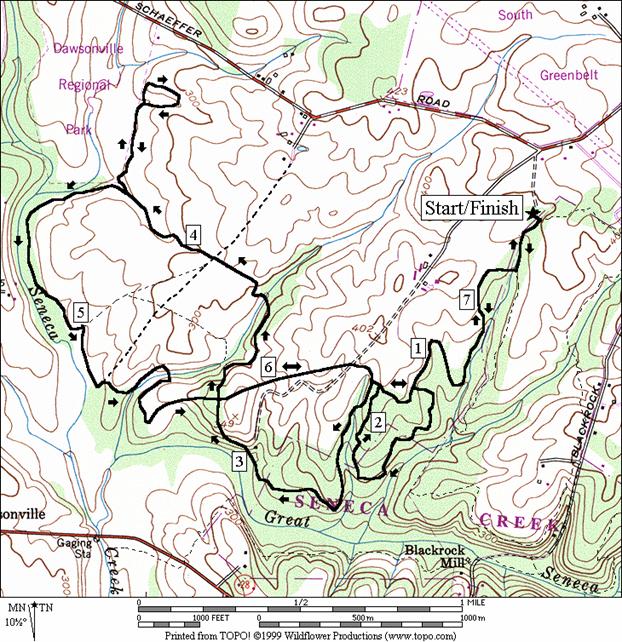
Schaeffer Farm Western Trails
Distance: 7.65 or 6.25 or 8.65 miles
Rating: VII or VI or VIII; dirt trails through
woods and fields, rolling hills
7.65
Mile Route
0.0 east
from parking
R 0.0 White
Trail (white blazes)
R 0.2 Yellow
Trail on R crosses transcontinental cable clearing
<*
BL 1.1 to
stay on Yellow Trail; Blue Trail on R; follow yellow blazes
L 2.1 at
T to stay on Yellow Trail (yellow/blue blazes)
BL 2.1 trail
X on R; Blue Trail goes in field
3.25 cross
roads marks beginning of Yellow Trail loop; Blue Trail on R joins; Yellow on L
is return loop
>*
BR 3.4 to
stay on Yellow Trail at Blue Trail on L
3.9 gravel
Rd on L to double-track is Blue Trail shortcut
<**
4.3 Red
Trail on R
>**
BR 5.0 to
stay on Yellow Trail at Blue Trail on L; trail to R enters trees
L/R 5.3 on
gravel road to stay on Yellow Trail; tower on R
S 5.85 crossroads
completes loop; S is Blue Trail; L & R is Yellow Trail
BR 6.3 onto
trail leaving double-track in the open field; to stay on the Blue Trail
L 6.45 in
woods; Yellow/Blue Trail
BL 6.45 Blue
Trail bears L; Yellow Trail goes R
S 6.6 Yellow
Trail joins from R
L 7.45 White
Trail after cable clearing
L 7.65 to
parking
7.65 parking

*6.25
Mile Route
BR 1.1 Blue
Trail on R
1.25 Yellow
Trail joins from L
R 1.25 Blue
Trail goes into field; Yellow Trail bears L
BL 1.4 onto
double-track in middle of field
R 1.8 cross
roads marks begining of Yellow Trail loop; Blue Trail
and Yellow on R; Yellow is S & L too (pickup cues at mile 3.4 on 7.65 mile
route)

8.65
Mile Route**
R 4.3 Red
Trail on R goes downs steep hill
BL 4.6 begin
loop; cross gully
BL 5.0 complete
loop; return
R 5.3 Yellow
Trail (pickup cues at mile 5.0 on 7.65 mile route)