Black Hill Regional Park, Little Seneca
Lake
Little
Seneca Lake, in Black
Hill Regional Park,
is a reservoir created after a previous drought struck the Washington
area. The park is under Maryland-National
Capital Park
and Planning Commission (MNCPPC) management and the 500 acre lake covers almost
one-third of it. Most known for its lake’s
boating fishing and birding opportunities, there are also paved and unpaved
trails, picnic shelters, playgrounds and volleyball courts. All trails are open to hikers, horseback
riders and mountain cyclists. Inside the
park boundaries, are the sites of an old gold mine and Waters Mill. The gold mine is located near the park
offices. It was used from the 1850's to
the 1950's but didn’t produce much gold.
The mill dates from 1810 and is located just off the Black Mill Trail
near Little Seneca Creek, just above the lake.
Some suburbs are on the park’s borders but most of the surrounding area
is rural (This is changing). When I was
visiting, a ranger warned of citing a black bear on the Field Crest Spur TrailBa highly unusual occurrence within the
park. In recent times the area has
gotten some publicity for being near the setting of the popular 1999 movie The
Blair Witch Project. The park is
open 5/1-10/31 6AM to sunset and 11/1-2/28 7AM to sunset. Camping is not allowed.
Getting
There
From
the Capital Beltway (I-495), take I-270 headed west. About 14 miles from the beltway, take Exit
16, Ridge Rd. headed east. Turn left
after 1 mile on Frederick Rd. (Rte. 355). Less than a mile later, turn left
onto West Old Baltimore Rd. Cross under I-270 and turn left into the park on
Lake Ridge Drive. Pay the nominal entree
fee at the gate. Go down the hill
passing the Visitor Center
on the right, then pull-in to the parking area also on the right for the boat
center. The trail head is at the very
end of the parking area. Start in front
of the restrooms and vending machines.
Area
Routes
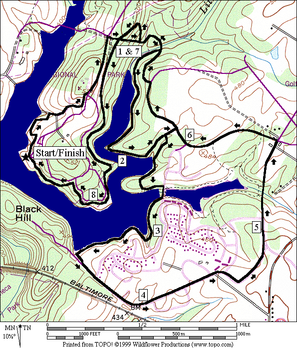
Black Hill Trail
(8.4 or 4.65 miles, IX or V)
Initially,
this twisted figure eight shaped loop is paved and hilly. It climbs to park offices near the gold mine
sight, then uses Lake Ridge Rd.,
the main road through the park. After
turning right and going down an unpaved gravel road to cross the Little Seneca
Creek, you pass the Waters Mill site and a flatter paved segment takes over. This paved section offers great views of the
water and lies between the lake shore and the back yards of houses. A short option continues straight where the
Black Hill Trail turns right to go around an inlet. Past that, the Black Hill Trail goes over the
older Churchill Lake
dam at Waters Landing Road. Churchill
Lake sits just above Little Seneca
Lake. It is private for the use of the
residents of Waters Landing. A 1.5 mile
paved trail loops around Churchill Lake
and that trail also connects to some other spur trails.
Past
the Churchill Lake
dam, the Black Hill Trail goes on but does not completely loop Little Seneca
Lake. The reason has to do with
distance, houses and the fenced-in enclosure at the dam. Tentative plans may one day change this. To get back, from the end of the trail, as
well as the short option turn-off, use suburban streets to loop
counter-clockwise. The regular route
thus makes a sort of concentric loop around Churchill
Lake (that lake is not visible on
the route). Another spur trail returns
you to Waters Mill. Use a switchback
trail to climb the steep hill after crossing Little Seneca Creek. At the top, after crossing the gravel road
you went out on, continue straight on what is the unpaved portion of the Black
Hill Trail. Though generally downhill,
there are some short steep climbs. After
a segment on an AT&T cable route, bear left onto the paved Black Hill
Trail. It circles the edge of Picnic
Lane, passes through a fitness course, and returns
you to the boat center parking lot.
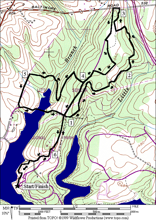
Hard Rock/Field Crest Spur and
Cabin Trails (6.55 or 5.1 miles, VI or V)
The
terrain covered on this loop is varied.
The paved Black Hill Trail makes and initial climb to Lake
Ridge Drive.
A couple of connecting trails bring you to the beginning of the Hard
Rock Trail. It is blazed in blue with
the white letters “HR” painted on top.
The trail lives up to its name in the beginning but much of it is smooth
wooded single track. It goes up and down
a little but overall doesn’t climb much.
At its end, turn right on the Field Spur Trail, also appropriately found
in a small succession forest field. Turn
around at West Old Baltimore Rd.
by getting onto Lake Ridge Dr.
at the park entrance. Make the second
left on a connector trail back to a different portion of the Field Crest Spur
Trail. Afterward, bear right at all
turns, until you return again to Lake Ridge Dr.
and continue downhill by turning left.
Turn right on the Cabin Branch Trail or proceed down the road past the
entrance gate to shorten the route. The
Cabin Branch Trail is actually a series of connected trails blazed in light
blue with “CB” painted on top. Turn
sharply left on the gentle downhill at the first opportunity and continue
descending. Turn right at the next
blazed trail. You’ll almost reverse
direction and cross a few hills and streams including one with a small
suspension bridge, before hitting the telecommunications line clearing. Turn left at this T intersection, dip down to
cross a creek again, then climb up to a good view of the lake. Use Black Hill Road
to cross an inlet of the lake, then climb up to Lake
Ridge Dr.
The short option joins back here.
Turn right on the drive, picking-up the paved Black Hill Trail shortly
ahead on the right near the park offices and gold mine. It’s mostly down hill back from there.
Nearby
and Connecting Zones
Black Hill Regional Park, Ten Mile Creek
Little Bennett Regional Park
Seneca State Park, Schaeffer Farm
What
to do Afterward
Food
and Drink
picnic
Bob
Evan’s - 21044 Frederick Rd.
- 301 515-6310
End
Zone - 301‑353‑9039
El
Amatillo - 301‑588‑7815
Stoltzfus
Baked Goods - 301‑916‑3881
Entertainment
and Edification
Boat
and Canoe rentals
Montgomery
County Fairgrounds - 301 963-3247
Black Hill Trail
Distance: 8.4 or 4.65 miles
Rating: VIII or V; mostly paved trails and
sidewalks with some dirt trails an steep hills
8.4
Mile Route
R 0.0 from
the restroom/vending building
L/R 0.15 trail
X’s before the Visitor Center;
go behind the Visitor Center
R 0.4 at
T; start climbing
R/L 0.6 at
park office; onto Lake Ridge Rd
R 0.9 gate;
gravel Rd to Black Hill (BH) Trail on R at Black Hill Rd on L
1.0 trail
X; S is BH Trail (steep downhill on rough gravel)
1.1 trail
X on L before bridge over Little Seneca Creek
R 1.2 at
trail X to stay on BH Trail; S & R
are paved; Waters Mill site
<*
R 2.25 at
trail X on R to stay on BH Trail
R 2.7 dam
at Water's Landing Rd to
stay on BH Trail; S is to Lake Churchill
R 2.8 at
trail X on R to stay on BH Trail
3.1 trail
X on L to pumping station road
BL 3.5 leave
the lake; Tr to R is dead end
BL 3.55 Wisteria
Dr; end of Black Hill Trail
4.0 Dr.
Martin Luther Kink Jr M.S.
L 4.7 Father Hurley Blvd
5.15 S
on dirt trail as paved trail goes down hill toward Lake
Churchill
5.25 paved
trail on L merges
L 5.45 Waters
Landing Dr after dirt path along the road
5.55 trail
X on L to Lake Churchill
6.05 trail
X on L from Little Seneca Lake and Black Hill Trail
>*
L 6.4 Spinning
Wheel Dr; go to the end
S 6.65 trail
head to Black Hill Trail
S 6.7 unpaved
Black Hill Trail is S; paved Black Hill Trail is L; Waters Mill
R 6.8 trail
X on R after bridge over creek
6.9 trail
X on R to Hard Rock Trail
S 7.0 cross
gravel road; S and L are Black Hill Trail (unpaved)
7.5 trail
X
7.6 stream
crossing
BL 7.75 AT&T
cable route
BL 7.8 leave
AT&T cable route
L 7.85 at
T on paved Black Hill Trail
7.95 pipline
L 8.15 at
T before Picnic La to stay on Black Hill Trail
8.4 parking/restrooms/vending

*4.65
Mile Route
S 2.25 leave
lake; trail X on R is BH Trail
L 2.35 Waters
Landing Rd (pickup cues at mile 6.4 on 8.4 mile route)
6.55
Mile Route
R 0.0 from
the restroom/vending building
L/R 0.15 trail
X’s before the Visitor Center;
go behind the Visitor Center
R 0.4 at
T; start climbing
R/L 0.6 at
park office; onto Lake Ridge Rd
R 0.9 gate;
gravel Rd to Black Hill (BH) Trail on R at Black Hill
Rd on L
L 1.0 trail
X; L is to Hard Rock (HR) Trail; S & R is BH Trail
L 1.1 trail
X on L to HR Trail
1.35 begin
HR Trail (blue blazes w/”HR” in white on top); trail X on L to Lake
Ridge Dr
1.7 trail
X; S to sunny area
R 1.9 at
T to stay on Hard Rock Trail
2.2 rock
piles
2.5 trail
bears left at field; following mowed grass to stay on HR Trail
R 2.6 at
T in field; Field Crest Spur Trail
2.8 AT&T
cable line trail on L
L 2.9 W
Old Baltimore Rd; use shoulder
L 2.95 Lake
Ridge Dr (park entrance)
3.0 AT&T
cable line trail
L 3.25 trail
X on L to Field Crest Spur Trail
BR 3.35 Field
Crest Spur Trail
BR 3.5 to
stay on Field Crest Spur Trail
BR 3.6 to
stay on Field Crest Spur Trail
L 3.7 Lake Ridge Dr
<*
R 3.85 Cabin
Branch Trail (light blue blaze w/”CB” on top); L is to HR Trail
L 4.0 to
stay on Cabin Branch Trail
4.1 Trail
X on R (unmarked)
R 4.35 Cabin
Branch Trail on R
4.65 suspension
bridge over stream
4.85 wooden
bridge over stream
L 5.0 at
T to stay on Cabin Branch Trail
L 5.3 Black Hill Rd
5.4 causeway
over lake inlet
5.55 Cabin
Branch Trail on L
R 5.65 Lake Ridge Dr
>*
R/L 5.95 R on
office driveway; L onto paved BH Trail
L 5.95 at
bottom to stay on Black Hill Trail
L/R 6.45 trail
X; Visitor Center
on L
L 6.55 parking/restrooms/vending
*5.1
Mile Route
4.05
Contact Station
4.2 Black
Hill Rd on R (pickup cues at mile 5.95 on 6.55
mile route)