Black Hill Regional Park, Ten Mile Creek
The
western end of the Black Hill
Regional Park
is far more rustic than the rest of the park.
Ten Mile Creek empties into Little Seneca Lake, and as in other parts of
the park, forms great fishing opportunities.
The land surrounding the lake is wooded and hilly. A few fields cleared long ago are now growing
new trees and sit 100 vertical ft. above the lake. The elevated fields offer some glimpses of
the lake however trees mostly obscure the view.
Few people use this part of the park but that might be good reason for
you to like it.
Getting
There
From
the Capital Beltway (I-495), take I-270 headed west. About 14 miles from the beltway, take Exit
16, Ridge Rd. headed
east. Turn left after 1 mile on Federick
Rd (Rte 355). Less than a mile later, turn left
onto West Old Baltimore Rd. Cross under I-270 and pass the main entrance for Black
Hill Regional Park
on your left. Six tenths of a mile
straight past the intersection with Clarksburg Rd. Rte 121, turn left onto the
gravel and dirt Ten Mile Creek Rd. Park on the side of the road before the gate
which prevents the public from driving further.
Do not block traffic.
Area
Routes
Osprey
Heights Loop (2.85 miles, IV)
Though
low in mileage, this route will still give you a suitable workout. Following Ten Mile
Creek Rd. downhill past the gate, you first cross
Ten Mile Creek, then go up and down along the lake shore on a grassy
trail. Passing the first couple of side
trails for Turkey Hill and Lake View
will avoid steep climbs on little used grassy trails. The view you get on the side loops is minimal
despite one of their names being Lake
View. The trail going straight, continues to climb
and fall before taking a big dip down to another creek. Climbing out of this pretty creek little
valley will place you in the fields of the Osprey
Heights loop. The grassy trails in and around the field are
maintained by mowing them. Bearing left
to go clockwise, drop down in elevation slightly but be careful not to go too
far. A side trail going steeply down the
hill will be on your left. Climb as you
begin to loop back, then drop back down again to complete the loop. The views are probably best during the winter
when there are no leaves. Go back the way you came over the roller coaster
trail.
Nearby
and Connecting Zones
Black Hill Regional Park, Little Seneca Lake
Little Bennett Regional Park
Seneca State Park, Schaeffer Farm
What
to do Afterward
Food
and Drink
picnic
Poulet
De France - 301‑972‑1180
Mi
Rancho Restaurant - 301‑515‑7480
Varsity
Scoops & Grille - 301‑916‑1422
Entertainment
and Edification
Boat
and Canoe rentals
Montgomery
County Fairgrounds - 301 963-3247
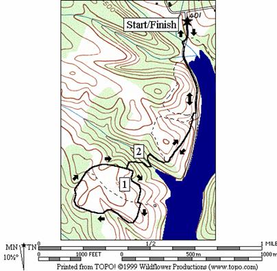
Osprey Heights Loop
Distance: 2.85 miles
Rating: IV; hilly grassy trails along
fields and some dirt trails
0.0 from
the gate go downhill
0.05 Cool
Spring Run Trail on L; cross the creeks on bridges
0.15 Turkey
Hill Loop on R
0.45 Turkey
Hill Loop on R
BR 0.45 at
fishing trail on L (unmarked)
L 0.5 toward
Osprey Heights Loop; S is Lake View Loop
BL 0.7 toward
Osprey Heights
Loop; Lake View
Loop on R
0.85 cross
the creek on stones
L 0.95 at
T after climb; Osprey Heights Loop
L/R 1.15 at T;
to stay on Osprey Heights Loop
S 1.7 at
trail X on L & R to stay on Osprey Heights Loop
L 1.9 loop
completed; trail X on L to Ten Mile Creek Road
2.0 cross
the creek on stones
BR 2.15 to Ten Mile Creek Road;
Lake View
Loop on L
R 2.35 at
T; R to Ten Mile Creek Road;
Lake View
Loop on L
2.4 fishing
trail on R (unmarked)
2.4 Turkey
Hill Loop on L
2.7 Turkey
Hill Loop on L
2.8 bridges
over creeks; Cool Spring Run Trail on R
2.85 gate
on Ten Mile Creek Rd
Osprey Heights Loop