![]()
*
L 1.0 trail X on L to wooden bridge over Rock Creek
BR 1.2 onto Linthicum St as spur trail ends at Marcia La
R
L 1.65 Fletcher Pl (pickup cues at mile 2.15 on 4.4 mile route)
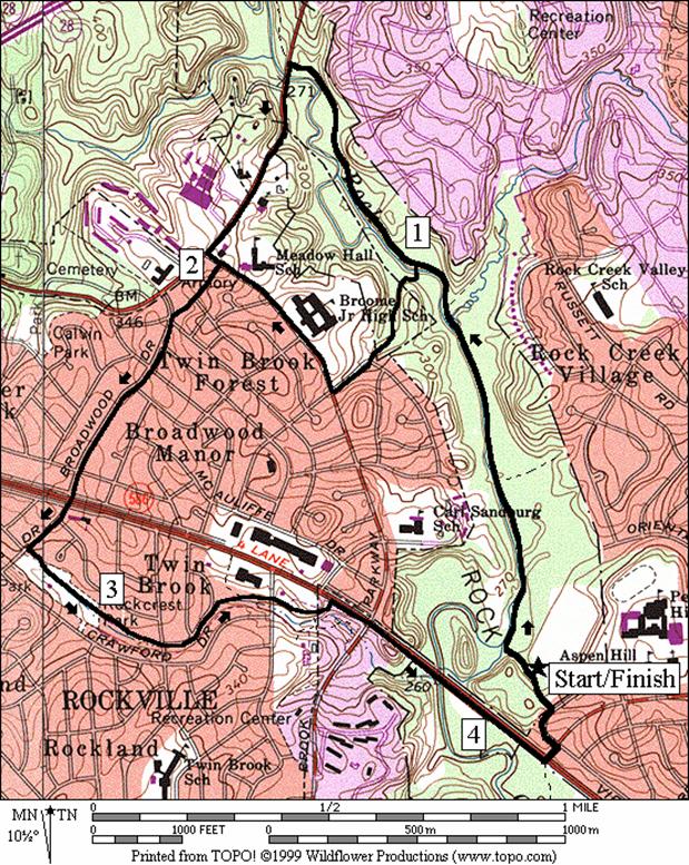
Getting There
From the Capital Beltway (I-495), take Rockville Pike (Rte. 355) northbound 3 miles. Turn right on the Twinbrook Parkway. After 1.25 miles, turn right on Viers Mill Road. After 0.6 miles, turn left onto Aspen Hill Road. Make an immediate left on Adrian Street, then an immediate right on Baltic Avenue. Parking for the park will be on your left.
Area
Routes
Twinbrook Trail (4.4 or 4.05 miles, III)
Leaving
the Aspen Hill parking area from the water fountain on the Rock Creek
hiker-biker trail, head north. The trail
drops a little at first as it nears the creek.
Turning northward, it is virtually flat and would almost offer good
training for beginner in-line skaters except for occasional drains crossing the
trail. The surroundings are mostly tree
covered however and the waters of the creek can be seen passing by
quietly. After just short of 1 mile turn
left on a spur trail for the first option; the only left hand turn off the
trail before Baltimore Road. It follows
suburban streets to the Twinbrook Parkway.
The second option turns left at Baltimore Rd. It climbs from there into Rockville along a
paved trail (it is not appropriate for in-line skaters) to the Twinbrook Parkway. Broadwood Dr., the next major straight-away
for both the options, is a shady and suburban residential area that takes you
to Viers Mill Rd. The Twinbrook Trail
head is reached shortly after crossing Viers Mill Rd. It is graded very gradually as it drops
toward Rock Creek. Along the trail are playgrounds, and houses. The portion of it on this route is suitable
for beginner in-line skaters though it is not long. Turn left after only one mile on it, at a
fork before a metal bridge. The fork
takes you to Viers Mill Rd. If you were
to continue further, the trail gets hilly and takes you somewhat away from Rock
Creek to
Nearby
and Connecting Zones
Rock Creek Park, Ken-Gar Palisades
Rock Creek Park, Lake Needwood
Seneca State Park, Lake Clopper
What
to do Afterward
Food
and Drink
Samwoo Restaurant - Korean and Japanese Cuisine, Rockville Pike - 301 424-0495
Fuddruckers - burgers - (301) 468‑3501
La Madeleine French Bakery - (301) 984‑2270
Entertainment
and Edification
Distance: 4.4 or 4.05 miles
Rating: III; paved trails, sidewalks, roads on mostly well graded hills
0.0 on
the Rock Creek trail (north) from the parking lot at
<*
1.0 trail X on L to wooden bridge over Rock Creek
L 1.55 paved trail at
L
CR
>*
L
L
2.8 Twinbrook Trail head
BR 3.35 trail merges from L
BL 3.5 up small hill at split in trail; before a metal bridge
R
3.7 Twinbrook Pkwy; use shoulder (!)
L
L
CR
L 4.3 into
4.4 trail head at water fountain
![]()
*
L 1.0 trail X on L to wooden bridge over Rock Creek
BR 1.2 onto Linthicum St as spur trail ends at Marcia La
R
L 1.65 Fletcher Pl (pickup cues at mile 2.15 on 4.4 mile route)