Rock Creek Park, District of Columbia/Maryland Border
If
you haven’t visited Rock Creek
Park before, this is one of the
best places to start. From here, you can
cover the northern portion of the park inside the District, as well as the
surrounding areas at the border of Washington, D.C.
and Maryland. The National Park Service maintains the park
inside Washington D.C.
borders. North of the District, Rock
Creek park is maintained by the Maryland
National Capital
Park and Planning Commission
(MNCPPC).
The
park is wider and hillier in the District.
It’s a large scale oasis of green space in the heart of the city. It offers paved and unpaved trails, ball
fields, picnic areas, horseback riding, golfing, a Nature
Center, an amphitheater, many
historical landmarks, and surprising natural beauty. It’s a real asset to the region, not just for
the city of Washington. It’s also generally unknown by those living
in the suburbs. The National Park
Service describes it as Aone
of the largest forested urban parks in the United
States, containing a wide variety of
natural, historical, and recreational features in the midst of Washington,
D.C.
Many
forces were involved in the creation of the park. The part inside the District was created in
1890 which makes it one of the oldest national parks. The sometimes wet valley and steep hillsides
were less attractive for early developments.
An article in the Washington Post (February 15, 1999 A17, by Marc Fisher)
on the creation of affluent Chevy Chase (located north
and west of the park) argues that developers wanted the park. According to that
article, one of the Chevy Chase developers was William
Stewart, then a Senator from Nevada
who said it took 2000 acres out of the market thus raising real estate
prices. The article continues to say Adevelopers also saw the park as a way
of buffering white Northwest from increasingly black sections on what they
called the wrong side of the park.
Economic disparity and differing racial predominance exists around the park
today but it’s not so clearly demarcated in terms of east and west of the park,
nor so plainly prejudiced.
North
of the city in Montgomery County,
the MNCPPC has done an excellent job in designing and maintaining the paved
Rock Creek trail. Amenities of the park
in Maryland in general are less
extensive but the paved trail is better.
The facilities and comforts in Maryland
include picnic areas, ball fields, ball courts, and Nature Centers. Routes in this section reach Silver
Spring, Bethesda, Chevy
Chase, and the northern part of Rock Creek park inside the
District.
Getting
There
From
the Capital Beltway (I-495), take Connecticut Avenue
south for 1.2 miles. Turn left on East-West
Highway (Rte. 410) following it 0.8 miles. Turn right on Beech
Drive proceeding on it for 1 mile. Turn left just before the District
of Columbia boundary line, into the parking lot.
Area
Routes
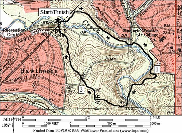
Boundary Lines (2.6 miles, II)
A
small wonder is what you will find in this short loop through the woods. People walking dogs, hikers, horseback
riders, and runners all seem to come here in comfortable, uncrowded numbers. They come to get away from it all and they
succeed too. Following the Valley Trail
(blue blazed) south, and over the bridge crossing the Rock Creek, the route is
wide and mostly smooth. Some segments
however, tend to retain water and stay muddy longer than others. For a way, the trail follows the park’s
eastern boundaries. A short climb after
the first mile is followed by a descent again to a tranquil wooded overlook of
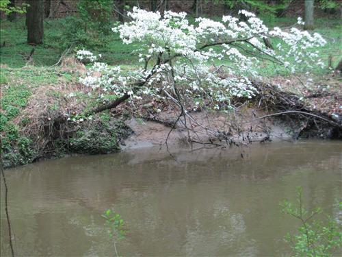
the Rock Creek. This view is dotted like
an Impressionist painting with blooming dogwoods in the spring. Leaving the Valley Trail and crossing Beach
Drive, the trail gets hillier with a steady and
sometimes rocky climb that’s nearly half a mile long. Once joining the Western Ridge Trail (green
blazed), the hardest work is over. Only
one more short but steep rise remains.
Relax and enjoy the view of the wooded hillsides on the way back
down.
|
|
|
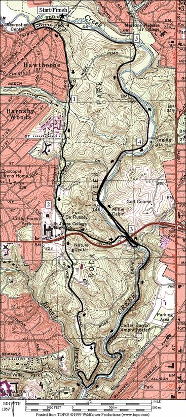
West Side Story (5.6
or 8.2 miles, VII or IX)
West
of the parking area along Oregon Ave.
is a lessor known paved hiker-biker trail that traverses lengthwise, most of
the main body of Rock Creek
Park. The trail is about 6ft wide, bumpy and hilly
so most cyclist forego it for the smoother Beach Dr.
that is closed on weekends. To get to
the trail from the parking lot, leave heading north into Maryland
on Beach Dr., then quickly
loop back into the District of Columbia
again on Daniel Rd. and Oregon
Ave. Along
the way you will pass many well kept houses in Chevy Chase. Just getting this far, you’ll have run up,
down, and up again over significant hills.
At the hiker-biker trail continue the roller-coaster motion as you
travel south and across the grain of the area’s drainage. Short portions of the hills can be
steep. Just before Military
Road the hardest work is done and the short and
long routes split.
Turn
left for the short route onto another unnamed hiker-biker trail and descend to Joyce
Rd. and Beach Drive. From that intersection the path along Beach
Dr. is fairly flat. The short route is on Beach
Drive after crossing Bingham
Dr. (the
long route joins the short route here too).
Back
at the split, the longer route crosses Military Rd.
and after a initial climb to the Nature
Center, it gets easier than the
first part of the route. Water and
restrooms are available in the Nature
Center. From there simply follow Glover
Rd. as it stair-steps its way down various small
plateaus past picnic areas. Eventually
the plateaus become a narrow ridge with views of the Rock Creek valley below. The ridge itself runs-out with a descent to Broad
Branch Rd. and Beach Dr. Return on Beach Dr. Most auto traffic is kept out on weekends (7AM Sat-7PM Sun & holidays). As elsewhere in the park, Beach
Dr.
parallels the Rock Creek. The
section from Broad Branch Rd.
on the way to Joyce Rd. is
more remarkable than elsewhere however.
The tumbling rapids of the creek make it more reminiscent of a fine
mountain stream in the Shenandoah National
Park than the usual stream found in a typical Washington,
D.C. city park. The creek falls (you will climb) more quickly
here than anywhere else along its natural course (70ft in 1.6 miles). The man-made and often photographed Boulder
Bridge seems to make a statement to
the natural beauty surrounding it. Stay
on Beach Rd. after the
intersection with Joyce Rd. At Bingham Rd.,
both the short and long routes join together.
Only
one more significant climb remains. It’s
a half-mile gentle and steady grade before Wise Rd. After the intersection, traffic is briefly permitted
on route. There is no trail or shoulder
on this short segment so some caution is necessary as drivers cross to the east
and west sides of the park. The home
stretch is almost flat.
Chevy Chase (9.05 miles, VIII)
The
land surrounding the Rock Creek Park on the north and west sides of the park is
Chevy Chase.
According to the same Washington Post article cited above, Athe name stems from the Cheviot
Hills which are along the English-Scottish border. Though “Hills”
was dropped from the name, it is an appropriate description. On this route, three well graded, marked and
maintained trails will get you over or around them. First take Beach Dr. north, and turn east to
cross the creek. This is actually the
Rock Creek hiker-biker trail maintained by the MNCPPC but it’s not very well
distinguished from the roads until after crossing East-West
Hwy. After
only 0.3 miles past East-West Hwy.
an old railroad bridge will be visible.
It rises high above, as the trail gets close to the creek and was once
part of the Baltimore and Ohio
railroad. The railroad right-of-way
still goes all the way to Georgetown. Part of it is currently named the Georgetown
Branch Trail and it is open for hikers and bikers. The railroad bridge is unusable now but it
will be rebuilt and become part of the existing Capital Crescent Trail in the
future.
After
the railroad bridge, cross back over the creek and turn left onto what is a
connector to the main part of the Georgetown Branch/Crescent Trail. The main trail at first is cinder and
shady. The trail very gradually climbs
through quiet neighborhoods. Cross
Connecticut Ave. at a traffic light then pass
between high fences while looking at the nicely manicured golf course of the Columbia
country club. In downtown Bethesda,
the trail becomes paved just before an 1,100 foot (0.2 mile) lighted tunnel
under Wisconsin Avenue. The tunnel avoids most of the Bethesda
traffic and marks the top of the hill.
The tunnel is open from 6AM to 10PM. After
exiting the tunnel, continue down the Capital Crescent
trail. Go only 0.6 miles, then leave the
trail at the Bethesda Pool (open to the public). Cut through the pool parking lot and cross Hillandale
Rd to another inconspicuous paved trail. This is actually the smaller segment of the
discontinuous Little Falls Trail. 100ft
later turn left on the unmarked paved trail up to and through Norwood
Park. The initial climb here is a bit steep. Sunny
Norwood Park
has ballfields, water and portable restrooms.
After
leaving the park the route is on the streets and sidewalks. A left on Wisconsin
and a right on Bradley Lane
will put you on the edge of the older part of Chevy Chase. At first you will border the Chevy
Chase Village
country club. After crossing Connecticut
Ave., as you get closer and closer back to Rock
Creek Park,
Bradley and the other roads become more personable. Houses and yards are well kept. Spring-time colors make it very
memorable. Its downhill too.
At
the left turn onto Beech St.
from Western Ave., the
route continues downhill. You may
optionally go straight 0.05 miles and, turn left on the unpaved Pinehurst Trail
(parallel to Beech St.) to get into Rock Creek Park sooner. The bumpy Pinehurst Trail crosses the creek
several times without bridges, then crosses Oregon Rd.
just like the queued route following Beech St.
does. It then intersects the bicycle
trail also. For your troubles on the
option, you get into the woods more quickly but add 0.2 miles to the route. Whether you take Beech
St., or the Pinehurst Trail to get there, turn
left on the hiker-biker trail to Wise Rd.
then return on the unpaved Western Ridge Trail to the parking lot.
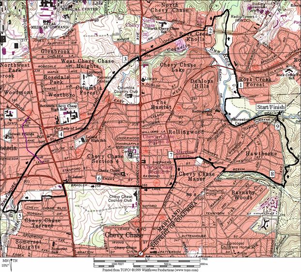
Silver Spring (5.55 or
6.65 miles, V or VI)
Silver
Spring is the missing link in travel along paved hiker-biker
trails that could connect Maryland’s
eastern and western trails around the Washington,
D.C. metropolitan area. There are designated bike routes through Silver
Spring, but these are on the roads. This route shows three ways that you can get
from the central network of trails at Rock Creek, to and from Silver
Spring. The Trail of Two
Cities route in the Sligo Creek/Wheaton/Northwest Branch section of this guide,
shows one additional way and also shows how to get from Silver
Spring to the Sligo Creek hiker-biker trail in the Anacostia
Tributary Trail System.
First,
take Beach Dr. north of the
District (maintained by MNCPPC), following the trail until it connects with the
Georgetown Branch/Crescent trail. Most
of this segment is actually on roads but it is through park land, usually light
in traffic. The Georgetown Branch trail
is at first a connector route that climbs upward on street sidewalks until it
hits the railroad grade. The unpaved
trail on the railroad grade will soon be paved and made part of the Capital
Crescent Trail (if the Coalition for the Capital Crescent Trail prevailByou can help them at 202 234-4874 or
www.cctrail.org). In 1999 the railroad
grade was a lonely place not well maintained.
After only a short way, the railroad grade runs out in an industrial
area. A detour on a bridge over an
intersecting and operational railway puts you on residential roads and
sidewalks in the Woodside neighborhood.
Traffic on the roads picks-up, then peaks at the Silver
Spring metro station. From
there, the reverse occurs. Traffic
decreases with the drop in elevation, all the way back into Rock
Creek Park.
The
longer route skips the Georgetown Branch/Capital Crescent Trail. Instead it goes further up the Rock Creek
Trail, past the wooded Audubon Society property, and then turns right on a
little used intersecting paved trail.
This trail is located just less than a tenth of a mile before where the
Rock Creek Trail crosses Jones Mill Rd. Identify it by a sign pointing to Linden
Lane. The
trail crosses the Rock Creek and curves right going between the hillside and
the Rock Creek. This quiet section of
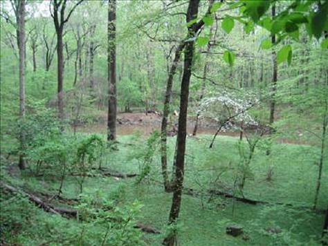
park was covered in an impressive uniform green carpet of flood-land springtime
undergrowth. The plants bloom with
hundreds of small yellow flowers. The
trail ends at a T intersection with an old and closed-off concrete surfaced
road. The road is Ireland
Lane and in either direction, it climbs through
the woods, along streams, and out of the valley. If taken to the right, it climbs steeply,
then dead-ends behind the Walter Reed Hospital Annex. Go left at the intersection instead. The climb is easier, it avoids the dead-end
and avoids a temptation to trespass on
Walter Reed property. The climb to the
left is lovely but takes significant effort.
From the T intersection to Linden Lane,
0.43 miles, it gains 130 vertical feet. Linden
Lane is semi-industrial and semi-
residential. Second
Ave., where you reconnect with the shorter route,
is residential until you get further into Silver Spring’s
downtown.
Nearby
and Connecting Zones
Bethesda
Rock Creek Park, Military Road
Rock Creek Park, Pierce Mill
Sligo Creek/Wheaton/Northwest Branch
What
to do Afterward
Food
and Drink
Delhi
Dhaba - Indian food - Bethesda -
301 718-0008
Il
Forno - Pizza - Bethesda
- 301 652-7757
Thai
Derm - Noodles House - Silver Spring - 301 589-5341
Entertainment
and Edification
Rock
Creek Nature Center
& Planetarium - 202 426-6829
National
Zoological Park - 202 673-4800
Carter
Barron Amphitheater - events such as Shakespeare in the Park - 202 426-6837
National
Capital Trolley Museum
- 301 384‑6088
Boundary Lines
Distance: 2.6 miles
Rating: II; some hills; unpaved blazed
trails through wooded parkland
S 0.0 Valley
Trail toward Rock Creek from the parking lot (blue blaze)
0.05 Boundary
Bridge over Rock Creek
0.2 Boundary
Trail on L
BR 0.65 to
stay on Valley Trail at X w/ramp to West Beach Dr
0.7 underpass
to West Beach Drive
BR 0.75 to
stay on Valley Trail at X w/ramp to West Beach Dr
1.0 rock
cliff on L; begin climb
1.3 Pine
Trail on L
1.4 trail
to overlook on R
R 1.5 trail
to Riley Spring
Bridge; (sign shows 1.6 miles to
Military Rd & 1.4 miles back to Boundary
Bridge)
1.55 cross
Beach Dr; follow trail into woods and up the hill
BR 1.85 Western
Ridge Trail; (green blazed)
2.05 cross
Wise Rd
S 2.6 cross
Beach Drive into parking
lot
West Side Story
Distance: 5.6 or 8.2 miles
Rating: VII or IX; hilly, on hiker-biker
trails and roads
5.6
Mile Route
R 0.0 north; on Beach Dr
from parking
L 0.25 Wyndale Rd
L 0.25 Daniel Rd
0.4 becomes
Oregon Ave at X w/Western
Ave; DC/MD border
BL 0.85 onto
hiker-biker trail at Wise Rd
BR 0.85 merge
with hike-biker trail
1.15 Pinehurst
Trail
1.55 Bingham
Dr (unmarked)
<*
L 2.2 on
paved trail before Military Rd
2.75 Military Rd.
underpass
BL 2.85 as Joyce
Rd crosses Rock Creek
BL 2.9 Beach Dr
3.2 bathrooms
on R across Beach Dr
BR 3.6 merge
onto Beach Dr at Bingham
Rd
>*
4.05 Sherrill Rd on R
4.35 gate
for weekend closure; (7AM Sat-7PM Sun
& holidays)
S 4.85 Wise
Rd on left (! traffic from cars crossing the park
& no shoulder)
BL 5.0 to
stay on Beach Dr at Wise
Rd (! gate for weekend closure)
R 5.6 parking

S 2.2 go
straight to cross Military Rd
BR 2.4 through
Nature Center
parking lot (water, bathrooms in the center on L)
R/L 2.45 to
leave parking lot; onto Nature Center
& maintenance access road
BL 2.65 Glover Rd
3.15 Ross
Dr on L merges
BL 3.85 paved
trail at bottom of hill; before bridge
L 3.95 Beach Dr
4.4 Boulder
Bridge
5.5 Joyce Rd
5.8 bathrooms
on R (open year round)
6.25 (pickup
cues at mile 4.05 on 5.6 mile route)
Chevy Chase
Distance: 9.05 miles
Rating: VIII; paved and unpaved trails, roads
& sidewalks; mostly well graded
R 0.0 north;
Beach Dr from the parking
lot
R/L 0.55 at parking
lot; follow Bike Route sign
to footbridge over Rock Creek; Meadowbrook La (water, bathroom)
BL 0.85 to stay on Meadowbrook La (stables)
BL 1.15 onto
paved trail after crossing East-West Hwy
(water at 1.25)
L 1.75 connector
TR to Georgetown Branch/Cresent Trail
L 1.9 Susanna
La (unmarked)
L 2.05 Jones Mill Rd
XS 2.05 at X
with Jones Bridge Rd; use
crosswalk
R 2.1 Georgetown
Branch/Crescent Trail
L/R 2.75 at
Conn Ave to cross Conn Ave at Chevy Chase Lake Dr TL
R/L 2.8 after
crossing Conn Ave; R on
sidewalk/trail then L on trail into the woods
CR 4.2 Bethesda Ave at Woodmont
Ave
L 4.25 Capital
Crescent Trail; before auto dealer lot
L 4.85 Little
Falls Pkwy and immediate L again through Bethesda Pool parking; cross Hillandale
Rd onto paved trail.
R/L 5.0 R at
T (Little Falls Trail); immediate L paved trail (to Norwood
Park)
L/R 5.3 Norwood
Park parking; pass Norwood Rd;
R onto paved trail (water and portable outhouse)
L 5.45 Norwood Rd
L 5.55 Wisconsin Ave
CR 5.65 Bradley Lane
CL 6.7 Brookville Rd
R 6.95 Turner
La; before gas station & stores; continue on footpath (7.2; water) at road
end and continue following Turner La downhill
L 7.4 Cummings
La
R 7.5 Western Ave
L 7.5 Beech St
S 8.1 at
Oregon Ave; into woods on unpaved
unmarked path
L 8.05 hiker-biker
trail in Rock Creek
Park
BR 8.35 trail
splits at top of hill before road
R 8.4 Wise Rd
L 8.5 Western
Ridge Trail (green blaze, unpaved)
9.05 parking
lot
Silver Spring
Distance: 5.55 or 6.65 miles
Rating: V or VI; varied roads, sidewalks and
paved trails; some urban areas
5.55
Mile Route
R 0.0 north;
Beach Dr from the parking
lot
R/L 0.55 at
parking lot follow Bike Route
sign to footbridge over Rock Creek; Meadowbrook La (water, bathroom)
BL 0.85 to stay on Meadowbrook La
<*
BR 1.15 onto
sidewalk to stay on Meadowbrook La after crossing East-West Hwy; leave Rock
Creek trail and Meadowbrook Park; follow Georgetown Branch Trail signs
L 1.2 Freyman
Dr (uphill)
L 1.5 Terrace Dr
S 1.6 leave
road to Georgetown Branch Trail; Grubb Rd
is on R
BR 1.65 merge
onto railroad grade
L 2.15 Stewart
Av;
R 2.15 Brookville Rd
R 2.4 Warren
St; use path at road barrier to continue on Warren
at 2.45
L/R 2.6 at
Louis Av; onto 3rd Ave
L 2.8 Grace Church Rd
at T
>*
R 2.95 2nd Ave
3.0 16th
St
R 3.8 Colesville
Rd, Rte 29 (metro)
3.9 East-West
Hwy
S 4.15 cross
16th St to N
Portal Dr (!)
L 4.6 E Beach Dr
R/L 4.7 Kalmia Dr & W Beach Dr
R 4.9 Beach Dr
R 5.55 into
parking lot to finish
BL 1.15 onto
paved trail after crossing East-West Hwy
(water at 1.25)
BR 1.75 connector
trail to Georgetown Branch/Crescent Trail on L; after crossing Rock Creek
R 2.3 paved
(initially) trail on R before Jones Mill Rd
crosses Rock Creek
L 2.6 onto
Ireland Ln at T (unmarked)
CR 3.05 Linden Ln
R 3.65 Second
Ave.(pickup cues at mile 2.95 on 5.55 mile route)