|
|
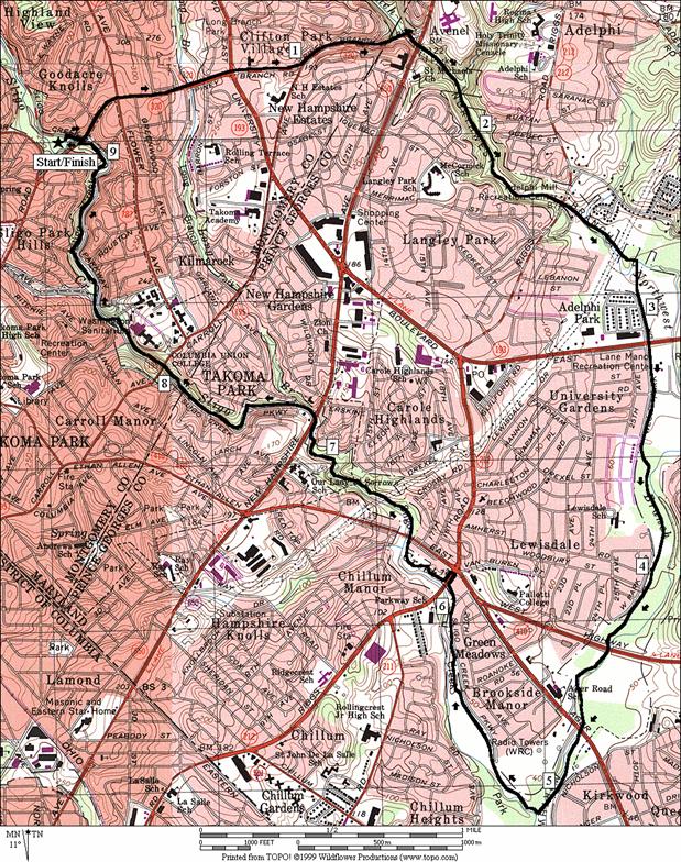
Sligo Creek/Wheaton/Northwest Branch
Once
before the time of air conditioners, Washingtonians escaped the muggy oppressive
summertime shores of the
Strategically
placed, Sligo Creek and its trail span 9.5 miles from
West Hyattsville to Wheaton Regional Park.
It’s a crucial east/west link in the network of paved pedestrian and
cycling trails in the
Getting There
From the Capital Beltway (I-95), take New Hampshire Avenue south for 1.2 miles. Turn right on Piney Branch Rd. proceeding 1.4 miles. Turn right on Sligo Creek Pkwy. and start one-tenth of a mile ahead on the left side of the road, from the parking lot near the tennis courts. Many other trail access points line the parkway also.
Area
Routes
Crossing up and out of the Sligo Creek valley near Takoma Park and dropping down to the Northwest Branch valley, near New Hampshire Avenue, one initially passes through the largely Hispanic sections of Takoma Park upon paved sidewalks. These sidewalks are relatively uninteresting for running and sometimes run-down but they don’t last long. The Northwest Branch Trail, is maintained just for hikers and bikers and is well worth the effort to get there. It parallels its namesake watercourse, is largely unknown and little traveled. That combination makes its beauty all the more a good thing to savor. From the trail, you’ll see small rapids pass through rocky banks and steep shaded hillsides. You’ll also pass by the Adelphi Mill, now converted to a recreation center. The mill was built in 1796 and was used as a grist mill and for wool carding. The route and trail change again quickly after the mill. It’s already less dramatic at the cricket field before hitting the crossing of University Blvd., Rte. 193 (If you want a shorter route and all you wish to explore is the Northwest Branch Trail, start at the cricket field parking (West Park Rd.) and follow the route backwards up and back the Northwest Branch). After Rte. 193, the trail continues through a more popular park and picnic area. It becomes less well maintained for a while aferward, with few signs to assure you how to stay on-trail at a few intersections. Keep in mind that some of the neighborhoods along here are low income and have higher than average crime rates. Take precautions. Watch where you are going and if you can, go with a friend. In Kirkwood Park, an un-herald intersection with another paved trail on the right marks the beginning of the Sligo Creek Trail, the return leg of the trip. After crossing the creek and getting though a thicket, large grassy fields open-up and serve as the local soccer hangout. After crossing Riggs Rd., a more celebrated trail head is marked with a large sign and map. The pavement and neighborhoods improve quickly and the surrounding parks get shady again. Some of the best parts of the trail and route are between New Hampshire Ave. and Piney Branch Rd.
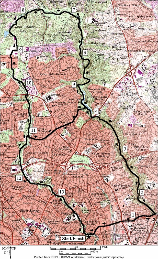
Northwest Branch (14 or 8.6 miles, X or VIII)
This route starts out on the same path as the Adelphi Loop, but when you hit the Northwest Branch Trail, instead of going downstream, go left and upstream. Footing for the much of the route is unpaved, and rough. Runners will be dancing their way over rocks and mud and through twists and turns. Those who look for this kind of excitement along with the scenery will love it.
On the route, the Northwest Branch trail is paved initially. It follows the V-shaped valley along the quiet but quickly flowing creek. Few people use the trail here. Perhaps it’s the obstacles of crossing two feeder streams without bridges or the apparent dead-end after them where the pavement ends, that keeps people away. The crossings are easy to get past. The water, when flowing, goes over flat concrete so that if you are on foot, you probably won’t get wet over the sole of your shoe, unless it’s been raining. The dead-end is actually a fork. Going uphill a quarter-mile and +100ft vertically, the right hand unpaved trail ends at Oakview Dr. The left hand trail however, is the beginning of what can be a six-mile unpaved adventure that continues along side the Northwest Branch. No bicycling is allowed on the unpaved portions of the Northwest Branch trail. At first, the footing is rocky and a few large fallen logs are likely to require climbing over. Rocks can be hidden under fallen leaves too. After passing under the Capitol Beltway, I-495 which is high in the air above, the trail improves significantly. Just before reaching Colesville Rd., Rte 29, your progress will slow again. Large boulders in the way require hiking over. Fortunately, they’ll slow you down enough to help you notice the small waterfalls and rapids in the creek. Once on the other side of Rte. 29, you can see water pouring over a dam. The trail remains unpaved. Consider the trail as un-marked but occasionally you might see a few blue blazes. Eight-milers, will turn off quickly, climbing up out of the valley on residential street sidewalks, then descending into the Sligo Creek valley for the return.
Fourteen
milers will follow along the Washington Suburban Sanitary Commission (WSSC)
pipelines which are mostly buried under the trail. A few dips in the trail at feeder streams
reveal unattractive aqueducts. However,
the four miles of secluded uninterrupted woods and trail are havens to
wildlife. Herds of deer, owls, Great
Blue Herons and Kingfishers can be seen.
A few rock formations make for peaceful settings along the trail and
stream which are calendar perfect in the fall.
Mountain Laurel blooms abundantly in May. When reaching Wheaton Regional Park, the dirt
and often muddy trail becomes cinder.
Many turnoffs abound but if you first head toward the nature center,
Trail of Two
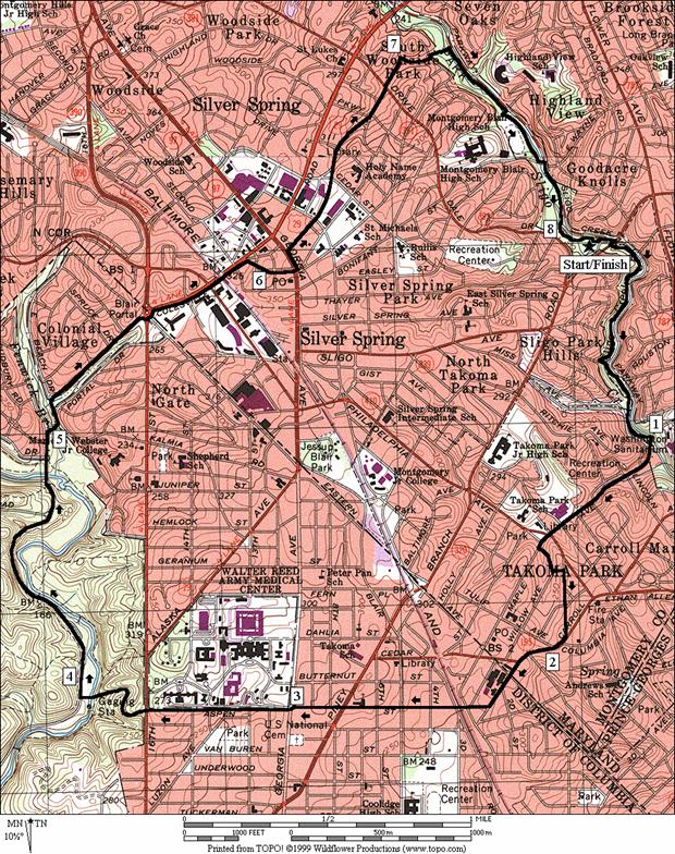
Cities (8.15 miles, VII)
This loop traverses between the linear Sligo and Rock Creek parks in two places. In-between the parks it passes through downtown Takoma Park on one end and downtown Silver Spring on the other. You’ll see both the town’s municipal clocks. Pedestrian traffic in the hearts of the downtown areas will slow you as will several road intersections. Once through these however you’ll see the better sides of city life as you pass through some of the more well kept and quieter urban areas. Springtime azaleas and other flowering shrubbery are great accents on-route. The trip through Rock Creek National Park is on park roads. Part of the roads are closed to cars 7AM Saturday-7PM Sunday and holidays.
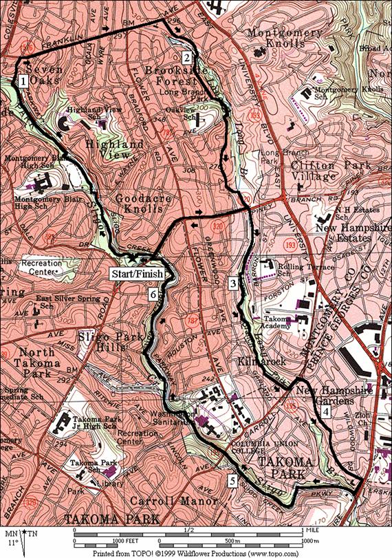
Long Branch/Sligo (6.4, 4.2 or 3.4 miles, VI, IV, III)
The relatively little known Long Branch Trail provides a good opportunity for making shorter trips in the area (don’t confused this with a trail by the same name that’s part of the Accotink Trail system in Virginia). The upper portion of the largest loop described, rambles through streets, fields, dirt and paved trails. Though there are many turns, the way is easy to follow because it stays parallel and close to the stream valley of the Long Branch. The community center off of Piney Branch Rd. is approximately at the half-way dividing line between upper and lower portions of the longest loop. Piney Branch Rd. provides options from there for the shortest loops. The lower portion of the largest loop is more defined by the paved Long Branch Trail. Residential streets finally connect the route to the return uphill leg along the Sligo Creek Trail.
Nearby
and Connecting Zones
Rock Creek Park, District of Columbia/Maryland Border
Rock Creek Park, District of Columbia, Military Road
Rock Creek Park, MD - Ken-Gar Palisades
Martin Luther King Jr. Recreational Park
What
to do Afterward
Food
and Drink
Mark’s
Kitchen - American, Korean and vegetarian meals; 301 270-1844;
Savory
- coffee, deserts, meals; 301 270-2233;
Takoma Park Farmer’s Market (Sundays
Taliano’s - pizza, subs & music - 301 270-5515
Entertainment
and Edification
Long Branch Community Center - gym, weight room - 301 431-5702
Brookside Gardens - well manicured landscaping & greenhouse - 301 949-8230
Brookside Nature Center - Wheaton Regional Park - 301 946-9071
Wheaton Regional Park Indoor Ice Rink - 301 946-7033
Adelphi Mill - off the Northwest Branch Trail
Chuck and Dave’s Bookstore - books, toys - 301 891-2665
National Capital Trolley Museum - 301 384‑6088
Site
of The Silver Spring; Newell St. and
American
Film Institute - planned for the future in downtown
R 0.0 Sligo Creek Trail, from parking lot
L 0.1 Piney Branch Rd; on sidewalk
0.75 University Blvd, Rte 193
L 1.5 on the ramp to the Northwest Branch Trail, just before New Hampshire Dr; left again onto the trail crossing under Piney Branch Rd
1.6 New Hampshire Ave underpass
1.8 drainage crossing
2.0 Denis Wolf Rest Stop (bench)
2.4 Riggs Rd underpass & Adelphi Mill
2.55 drainage crossing
2.95 Cricket field, (alternate parking/start)
3.15 University Blvd, Rte 193
3.2 Lane Manor Park; X trails, stay parallel to West Park Dr (water/toilet/pool)
3.35 Lane Manor Park road (unmarked)
3.65 drainage crossing
3.75 drainage crossing
4.4 East-West Hwy underpass
BL 4.55 at wooden bridge & parking lot to stay on NW Branch Trail (unmarked)
BR 4.6 trail X at football/soccer field to stay on NW Branch Trail
4.75 Ager Rd underpass
5.0 pass near X on L of Nicholson St & The Mall; see large water tanks straight ahead
R 5.1 Sligo Creek Trail head (unmarked; wooden bridge over Northwest Branch)
5.7 Green Meadow Community Center (water when open)
BL 6.0 Sligo Pkwy (onto shoulder)
R/L 6.2 Riggs Rd (trail is straight ahead but no crosswalk; cross at Riggs Rd/East-West Hwy TL; water)
R 6.3 Sligo Creek Trail head at
6.45
R/L 7.2 cross New Hampshire Ave after wooden bridge to stay on trail
L 7.5 Garland Ave; after wooden bridge to stay on trail
7.95 Carroll Ave bridge underpass
8.4 narrow wooden bridge (!)
L/R 8.55 Park Valley Rd stone bridge
R/L 9.1 Piney Branch Rd
L 9.2 into tennis court parking lot
Distance: 14 or 8.6 miles
Rating: X or VIII; sidewalks, paved and unpaved trails through stream valleys
R 0.0 Sligo Creek
Trail, from tennis parking lot
L 0.1 Piney Branch Rd; on sidewalk
0.75 University Blvd, Rte 193
L/R 1.5 ramp past bridge to Northwest Branch Trail,
just before
2.25 water drainage (!)
S 2.6 begin dirt trail (rocky next 0.3 mile)
2.9 Capitol Beltway underpass
3.85 boulders/rock scamper/waterfalls ahead
BL 4.0 parking lot
CL 4.1 Colesville Rd,
Rte 29 (!)
R 4.15 trailhead and gully, after bridge over creek
4.25 dam on R
<*
BR 4.45 trail X before wood bridge & aqueduct on
R
BR 4.65 trail X, wood bridge & aqueduct on R
BR 4.85 trail X, wood bridge & aqueduct on R
R 5.0 after double blue blaze, down, cross gully
BR 5.05 trail X
L/R 5.95 open area, X gully, mud & rock cliff
ahead
6.2 small gully
6.6 begin gravel & cinder trail surface
6.95 overhanging rock
S 7.65 at Kemp Mill Rd X (Wheaton Reg Park)
R 7.75 horse trail loop (signs toward nature center)
7.9 go uphill; pass sign and dirt trail
pointing to nature center
R 8.05 sign: 1/8 mile to nature center
R 8.1 Tom’s trail; toward nature center)
BL 8.2 through nature center parking (water & restrooms);
trail to Pine Lake at end of parking
R 8.4 sign: Pine Lake 1/4 mile
L 8.65 at Pine Lake; trail toward athletic complex
sign shows 1/4 mile
S 8.75 through ice rink parking; continue on road
bear R past the tennis courts
S 9.35 becomes
L 9.55 Sligo Creek trail
(food/water on L at 9.95)
CR
L 10.3 Sligo Creek trail
(11.1, water on L)
>*
11.15 Dennis Ave (unmarked)
11.8 Forest Glen Rd (unmarked)
11.9 Capital Beltway underpass
L/R 12.45 at wooden bridge to stay on trail
13.1 water to R near tennis ct
R/L 13.5 at wooden bridge to stay on trail
L/R 13.65 Wayne Rd (cross at TL)
R 14.05 tennis court parking
![]()
*
BL 4.45 aqueduct and trail X; leave NW Branch
BR
L 5.95 Sligo Creek trail
unmarked (pickup cues at mile 11.15 on 14 mile route)
Distance: 8.15 miles
Rating: VII; paved trails through stream valleys, urban sidewalks, paved roads
R 0.0
CR/L 0.1 Piney Branch Rd; to stay on trail; cross Sligo Cr 4 more times ahead
L/R 0.65 at
0.8 narrow wooden bridge (!)
CR
L 1.55 Valley View Ave (! one-way opposite direction, use sidewalk)
R
R
S 2.1 becomes
R
2.4 metro and RR underpass
2.85 Piney
R 3.85 Beach Dr (gate for weekend closure)
4.1 gate for weekend closure
4.3 trail X (footbridge to R)
BR 4.65 to
stay on
R
R/L
5.05
CR
XS 5.2 N Portal
5.5
5.8 Rte 410 East-West Hwy & metro
CR
CL
CR 6.25 Ellsworth Dr (follow bike route signs)
6.35 Fenton Dr (one way opposite direction road ahead-use walkway)
R
L/R 7.15 Bennington Ln & down toward Sligo Creek
BL/R 7.2 trail X; to wooden bridge (! stairs at end of bridge-water near tennis courts); R at T on Sligo Creek Trail
R/L 7.35 bridge; to stay on trail & X creek
L/R 7.75 at
7.95 wooden bridge over creek
8.1 wooden bridge over creek
R 8.15 into parking lot to finish
Distance: 6.4, 4.2 or 3.4 miles
Rating: VI, IV or III; paved trails through stream valleys, urban sidewalks, paved roads
<*
L 0.0
L/R 0.4 at
R/L 0.55 at wooden bridge to stay on trail
0.95 water at tennis court on L
R 1.0 cross
L/R 1.1 Hamilton Ave; stay on
R
R 1.75 Seminole
BR 1.8 Long Branch Pkwy (gravel road; small grass
field)
R/L 2.0 R on wooden bridge; L on
L
BL 2.2 E Schuyler St; dirt trail heads to L; runs
onto
L
BR 2.5 up the dirt trail into the park; proceed
counter-clockwise around tennis court
L 2.6 Long Branch Trail (paved w/sign showing 1.2
to
2.7
<**
>*
R/L 2.9 bridge over
BL 3.3 onto
BL 3.35 onto Long Branch Trail (at X with
S 3.6 onto
L 3.7 Carroll Ave on sidewalk
R
R
R 4.4
L 4.7 Garland Ave; after wooden bridge to stay on
trail
5.15 Carroll Ave bridge underpass
5.6 narrow wooden bridge (!)
L/R 5.75 Park Valley Rd stone bridge
R/L 6.3 Piney Branch Rd
>**
L 6.4 into tennis court parking lot
![]()
*
R 0.0
L
R 0.6
![]()
**
R 2.8 Piney Branch Rd (on sidewalk)
R 3.3 Sligo Creek
Trail; after