College Park/Riverdale
College
Park was not originally named for the University
of Maryland. It was named for the airport where the Wright
Brothers came to perfect their sciences after their historic first flights in North
Carolina.
Riverdale is College Park’s
nearby neighbor and as its name describes, sits close to the Northeast Branch
of the Anacostia River. There are stark contrasts in the wealth of
the two neighborhoods but both have good parks and places to get outside. The starting point is on the Northeast Branch
Trail, about 2 miles south of Lake Artemesia. Open flat and grassy flood plain
characterizes the nearby terrain. Hills
can be found by going nearer the university.
The Northeast Branch Trail is good for running, cycling, and in-line
skating.
Getting
There
From
the Capital Beltway (I-95), take Kenilworth Avenue
(Rte. 201) south and inside the Capital Beltway for 2.75 miles.
Turn right on River Road
following it only 0.25 miles. Turn left
on Haig Drive into the
park. The road curves left, then right.
Park 0.4 miles from River Road
near the restroom and water fountain.
Area
Routes
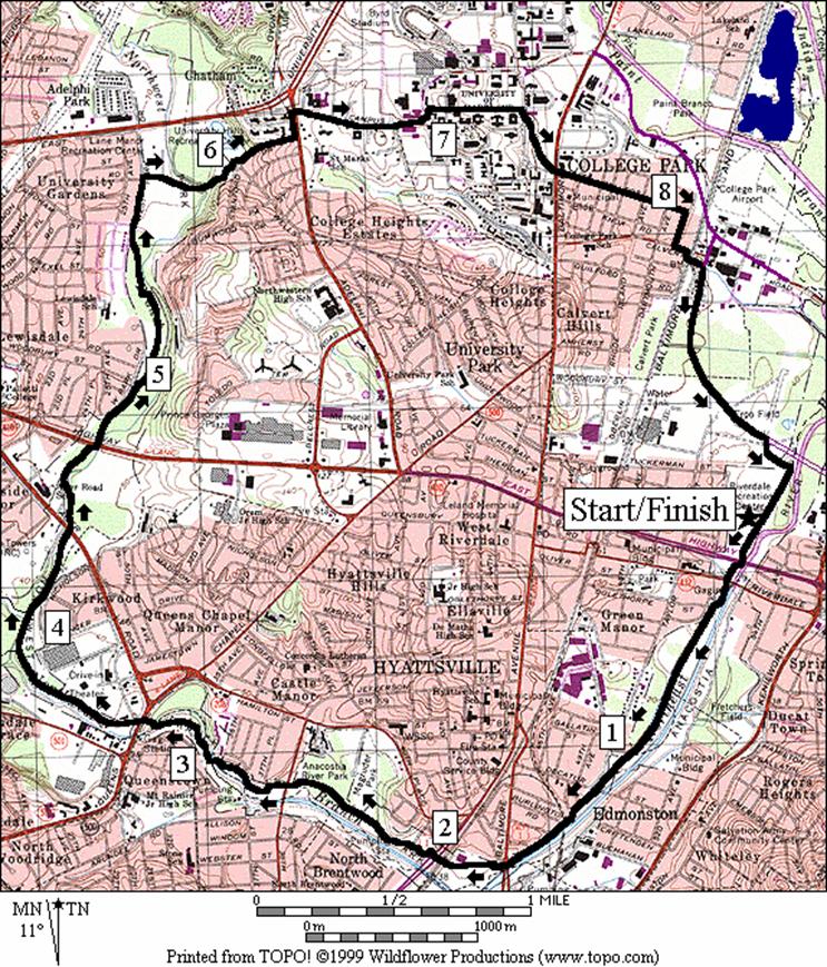
Northeast by Northwest (9.6 miles,
VIII)
This
generally flat route, along the two major Anacostia
River tributaries on paved trails,
will show you the great variation of the area.
Going downstream, the flood plain widens gradually. Long stretches of the trail are on top of a
dyke. It can be very sunny and sometimes
windy in winter. You may also want to avoid this route on hot days or if
thunderstorms threaten. The beginning of
the Northwest Branch Trail at an intersection on the right is unannounced. One would little expect that from there by
trail, can be reached Sligo Creek, Long Branch,
or Wheaton Regional
Park. The neighborhoods at lower portion of the
Northwest Branch appear less well-to-do economically. Going upstream, the open areas eventually
give-in to quiet woods. The seclusion of
a few spots will warrant traveling in groups for some. Leaving the stream valley in a steep climb
(the only major climb of the route), you will become part of the hustle and
bustle of students traveling to-and-fro at the University
of Maryland. The famed and stately Quad is the heart of
the campus. It could hardly be more
different from both of the earlier trails.
Crossing the Chapel Intermural Fields and Baltimore
Ave. (Rte. 1), College
Avenue offers a different look at university life,
with many fraternal or sorority houses on both sides of the street. Cross under the train and metro tracks at the
College Park - University
of Maryland station. The final leg is along River
Rd. a relatively new corporate office park
road.
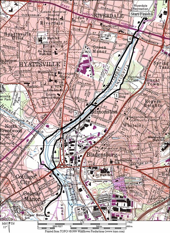
Double Northeast (4.65, 2.5,
or 5.85 miles, III, II, IV)
There
are two sides to practically everything.
On this route you get a chance to see both. Heading south on the Northeast Branch Trail,
cross to the east side of the widening river at Riverdale
Rd. Taking
a park road, you’ll pass some picnic spots and ball fields. Though there are large trees nearby, they are
too far from the road to offer shade or protection from wind. A small rise in the road is the crossing of a
dyke. Take the dirt trail on top of it
to the right, staying in view of the water.
The crossings of some roads and a railroad track interrupt the rhythm on
the dyke but also offer alternatives for a shorter route. Bladensburg Rd.
is the last best way to loop back on the west side of the river. When hitting the paved trail, you have yet
another option, to turn right for an out and back trip to Colmar
Manor Community Park,
or to turn left and return more directly.
The end of the Northeast Branch Trail at Colmar Manor, is at an open
ballfield area on top of a hill. It’s
high enough to let you see most of the way back to the start. The return along the Northeast Branch Trail
is paved, and mostly open. You are
likely to see people fishing the stream and if you are lucky, you may as I was,
be surprised to spy a deer.
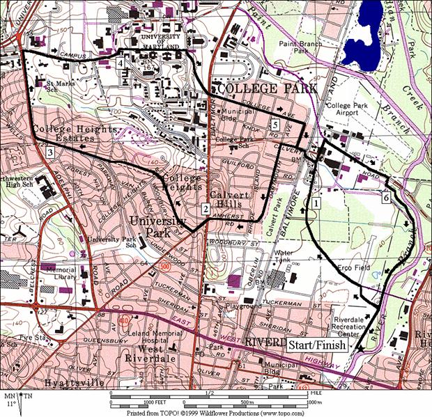
Mansion Hills, 7.95
miles, VII
See
the hidden side of College Park on
this route through its quiet neighborhoods.
The route returns through the University
of Maryland. Begin by heading to the College
Park - University
of Maryland metro station, using
the underpass there to get to the other side of the tracks. The Calvert Hills neighborhood on the other
side has large houses mature trees and little traffic. The flatness abruptly gives way to a steep
climb on Amherst Rd. Crossing Baltimore
Ave., Rte. 1, you will be in University
Park. The trees
and auto traffic there are similarly light but the houses are even larger. The grounds show the well manicured efforts
of university professors and local politicians who live there. Loop back on Adelphi
Rd., Campus Drive,
through the Quad, and back to the metro station. Finish on a quiet segment of the Northeast
Branch Trail south of the Paint Branch Parkway
to the parking area.
Nearby
and Connecting Zones
Lake Artemesia
Greenbelt Park
Sligo Creek/Wheaton/Northwest Branch
What
to do Afterward
Food
and Drink
Santa
Fe Café - 301 779-1345
Pho
Ninety Nine - Vietnamese - 301 445-1431
Seven
Seas Restaurant - 301 345-8500
Food
Factory - Indian fast food - 301 345-8888
Entertainment
and Edification
College
Park Airport Museum
- 10AM-5PM daily; 301 864-6029; TTY
301 864-4765
Riversdale
Mansion - plantation life in the
early 1800's - 301 864-0420, TTY 301 699-2407
Herbert
W. Wells Ice Rink - 301 227-3717
Kenilworth
Aquatic Gardens
- 202 426-6905
Calvert
Rd Community
Park Disc Golf
Northeast
by Northwest
Distance: 9.6 miles
Rating: VIII; paved trails through
parkland; university campus, sidewalks
0.0 Northeast
Branch Trail south and down stream from the parking lot (water/restrooms)
0.2 underpass;
East-West Hwy, Rte 450
0.3 Riverdale Rd
1.2 Decatur St
1.4 RR
underpass
1.65 Baltimore
Ave underpass
R/L 1.7 Northwest
Branch Trail; (unmarked) up small hill; along Armentrout Dr
1.95 Rhode Island Ave,
Rte 1
2.6 38th
Ave and park
R 2.95 after
bridge at T to stay on trail (unmarked)
R 3.25 trail
X; over bridge to stay on trail (unmarked)
3.35 Queens
Chapel Rd (!)
BR 3.85 toward
small wooden bridge at TR X; L crosses Northwest Branch (unmarked)
4.0 Sligo
Creek Trail head; bridge on L
4.35 Ager Rd underpass
4.7 East
- West Hwy underpass
R 5.75 Lane
Manor Park Rd (unmarked); before basketball courts (detour off-route 0.2 miles
further S for water); becomes a trail in 0.15 miles
R/L 6.05 at University
Hills Park
parking; R to leave parking & L onto Stanford St
and up the hill
L 6.35 Adelphi Rd
R 6.45 Campus Drive;
University of Maryland (!)
6.85 Mowatt Ln
L/R 6.95 at T;
cross bearing L around Queen Annes Hall & R before Anne Arundel Hall;
downhill on the walkway through The Quad
CR 7.35 at
T; Regents Dr; cross and BR
in front of Lee Hall
BL 7.35 downhill
diagonally across Chapel Intramural Fields on the walkway toward College
Ave
S 7.55 cross
Baltimore Ave, Rte 1 (!);
onto College Ave
R 8.1 at
T; Columbia Ave
L 8.25 Calvert
Rd; cross RR at end of road and continue under metro tracks (!)
R 8.4 at
T; River Rd
CR 9.2 Haig Dr
R 9.4 Northeast
Branch Trail and parking area
9.6 parking;
(water/restrooms)
Double
Northeast
Distance: 4.65, 2.5, or 6.05 miles
Rating: III, II, IV; paved and unpaved
trails, roads
4.65
Mile Route
0.0 Northeast
Branch Trail south and down stream from the parking lot (water/restrooms)
0.2 underpass;
East-West Hwy, Rte 410
L 0.3 Riverdale Rd
R 0.35 Tanglewood Dr; Anacostia
River Prk
R 0.95 after
rise; onto dirt trail on dyke
<*
1.25 Decatur
St (unmarked)
1.55 cross
RR (!); stay on dyke
L 1.75 Balt
Ave; Rte 1 Alt (unmarked)
XS 1.85 at
Upshur St (unmarked) (!)
R 1.95 Old
Port of Bladensburg Comm Prk; cross wooden bridge & up to dyke
L 2.0 on
dyke
R 2.3 Bladensburg Rd,
Rte 450
R 2.35 gravel
ramp to trail
<**
L 2.4 Northeast
Branch Trail
>**
2.8 wooden
bridge over Northwest Br
2.95 Northwest
Branch Trail on L
3.0 Baltimore
Ave underpass
3.25 RR
underpass
3.45 Decatur St
>*
4.35 Riverdale Rd
4.45 East
- West Hwy, Rte 410, underpass
4.65 parking
(water/restroom)

*2.5
Mile Route
R 1.25 Decatur
St (unmarked)
R
1.3 Northeast
Branch Trail; (unmarked); (pickup cues at mile 4.05 on 4.65 mile route)
**6.05
Mile Route
R 2.4 Northeast
Branch Trail (unmarked)
U 3.1 at
Colmar Manor
Comm Park
parking (unmarked)
S 3.8 trail
X on L to Bladensburg Rd
(pickup cues at mile 2.8 on 4.65 mile route)
Mansion Hills
Distance: 6.75 miles
Rating: VII; roads and sidewalks
0.0 North
on Northeast Branch Trail through the parking area
L 0.2 Haig Dr on the
footpath (umarked)
L 0.4 River Rd
L 1.2 College
Park - U of MD station; through the pedestrian tunnel and across the RR tracks
S 1.25 Calvert
Rd
L 1.35 Dartmouth
Av
BR 1.8 Amherst Rd
BL 2.0 Queens
Chapel Rd; after crossing Baltimore Ave,
Rte 1
R 2.1 Clagett
Rd at X w/44th Ave; becomes Wells Pkwy
R 3.1 Adelphi Rd
R 3.55 Campus Rd;
University of Maryland
3.9 Mowatt Ln
L/R 4.0 at
T; cross bearing L around Queen Annes Hall & R before Anne Arundel Hall;
downhill on walkway through The Quad
CR 4.4 at
T; Regents Dr; cross and BR
in front of Lee Hall
BL 4.4 downhill
diagonally across Chapel Intramural Fields on the walkway toward College
Ave
S 4.6 cross
Baltimore Ave, Rte 1 (!);
onto College Ave
R 5.15 at
T; Columbia Ave
L 5.3 Calvert
Rd; cross RR at end of road and continue under metro tracks (!)
L 5.45 at
T; River Rd
R 5.5 Paint Branch Pkwy
R 5.8 ramp
to Northeast Branch Trail; after ice rink
BR 5.9 on
wooden bridge after Denis Wolf Rest stop
6.45 River Rd underpass
6.55 merge
w/Haig Dr
6.75 parking
(water/restrooms)