Martin Luther King, Jr. Recreational Park


Virtually unknown to people not nearby to it, Martin Luther King, Jr. Park (MLK) in eastern Montgomery County has some secrets to reveal.  As part of the Anacostia watershed, it lies in obscurity because it is not as well connected with the large trail system as the other parks in the watershed are.  It is connected however and once within it, you’ll see that there are fine trails to explore.  On the eastern end of MLK is the Paint Branch creek valley and park.  A little past the western end is the Northwest Branch creek valley and park.  The Maryland-National Capital Park and Planning Commission (MNCPPC) may one day connect MLK with the Paint Branch Trail that originates in College Park.  Currently however, the Naval Surface Warfare Center (NSWC) and Interstate 95 lie in-between.  The Devil’s Den cave (off-limits to the public) is inside the NSWC grounds at what is known as the Paint Branch Gorge, an area of rocky cliffs.  The Eyes of the Paint Branch environmental group, citing local lore, reports the cave to have been a stop on the Underground Railroad during slavery times.  Hikes to it are held periodically by reservation.  The group also reports efforts by the Navy to rid that area of toxic wastes left by items stored there during the 1940's.  Well back upstream from the toxic wastes, MLK has facilities for baseball, outdoor tennis and basketball.  Area swimmers flock to the fine natatorium.  A small lake and concentric trails run through the hillside park.  


Getting There


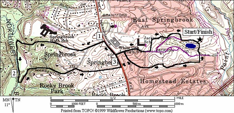
From the Capital Beltway (I-495), take New Hampshire Ave., Rte. 650 headed west.  Pass under Columbia Pike, Rte 29 and go 0.8 miles before turning right at the traffic light on Jackson Rd.  Pass the middle school and elementary school on the left, then turn left on the first road inside the park.  Look for, and turn left, into the parking lot for Ballfield 1 which is across from the small lake on the right. 


Area Routes


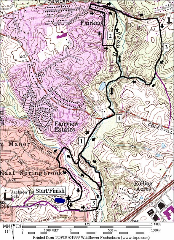
Serpentine Way (5.35, 4.85, 5.35, or 5.15 miles, V, IV, V or V)

As you head downhill from the parking lot on the paved trail, briefly pass through a neighborhood, then pick-up the Paint Branch Trail in Paint Branch Park (note a separate Paint Branch Trail further south along the same creek in College Park does not as of yet connect to this trail).  The trail continues dropping until you reach the Paint Branch creek.  Following it north and upstream, pass the Pilgrim’s Way Nature Trail on the right, then climb a steep hill to a spur trail intersection that goes to Laurie Dr.  This spur is later used as a optional return route.  Dropping back down to the Paint Branch, you’ll pass the other end of the Pilgrim’s Creek Nature Trail which can be used later as another optional return route.   Past these optional returns.  Ahead, a newly built underpass gets you safely past the old dangerous intersection with East Randolph Rd. 


On the other side of E. Randolph Rd., a public parking area on the left identifies the area as the sight of Snowden’s Mill.  The Snowden family centered around Laurel Maryland, once owned much of what is now Montgomery County.  The house near the lot is private property.  In the woods ahead, a raised pond on the left near a steep hillside, offers people a chance to reflect on their thoughts and the view.  The acoustics of this pond and the hills make a natural amphitheater that was good enough for a woman visitor I saw, to practice (very nicely) her classical singing there.  Just ahead, a turn-off on the right across the rocky boulder strewn creek is the trail to Serpentine Way creek.  Pass this on the way out so as to make the hill ahead more gradual when looping back.  The trail ahead rises gently to Fairland Rd.  At the road, follow the awkward dog-leg of the trail to the left.  Optionally continue in this direction for a flatter counter-clockwise loop back to the Paint Branch Trail.  For the regular route come back clockwise on the wide shoulder of the road, cross the Paint Branch creek and proceed up the long hill on an asphalt side trail.  Most of the way up, turn into the neighborhood using the sidewalk of Serpentine Way (a road).  After a long downhill, turn onto the trail which follows the tributary to the main creek. The trail serpentines back and forth over the tributary, passing interesting boulders before returning to the main trail.  From here the regular route goes back the way it went out. 


Pilgrim’s Way is the next option on the way back.  The unpaved trail rides along the Paint Branch creek precipitously close at times but is a nice way to avoid a hill.  It’s only two-hundreths of a mile shorter than using the paved route, has some roots and rocks to navigate past and is not recommended when wet.  The optional turn to Laurie Dr. goes through suburban streets and also reduces the hills, but is less aesthetically pleasing than just staying within the Paint Branch Park is. 


Springbrook (3.95 miles, III)

Another secret of the area surrounding MLK is the Springbrook neighborhood.  Climbing and winding your way out of the MLK on paved trails, the route takes you across New Hampshire Ave.  A row of trees hide the nice neighborhood on the other side.  Once there, you change watersheds and it’s as if you instantly leave the suburbs to find yourself on a road in a rural countryside.  The road continuously drops to the Northwest Branch Park.  The countryside illusion is complete with a barking dog that occasionally runs out to cheer you along.  Looping counter clockwise for a short way along the Northwest Branch, the route then comes up a similar road past beautifully landscaped homes, back to MLK.  To finish, the route completes a loop around MLK park (alone, the loop inside the park is 1.15 miles). 


Note that when in the Northwest Branch Park, some trail extensions are possible however the ones off route are not well kept nor easy to follow through their many turns.  If you wish to explore however, a single bridge to the other side of the creek is reached by following the main creek north almost to Wheaton Regional Park.  The better kept Northwest Branch Trail is on the far side of the creek. 


Nearby and Connecting Zones


Sligo Creek/Wheaton/Northwest Branch

Lake Artemesia


What to do Afterward


Food and Drink

Chesapeake Bagel Bakery - 301 681-0100

Hunan Manor - 301 681-5360

Chef Theo’s - 301 593-5350


Entertainment and Edification

Martin Luther King Jr. Park - indoor swimming, tennis, basketball - 301 622-1193

Brighton Dam Azalea Garden - 5 acres under hardwood forest by the lake; plantings from 1949 - north on New Hampshire Ave., right on Brighton Dam Road

Brookside Gardens - well manicured landscaping & greenhouse - 301 949-8230

Brookside Nature Center - Wheaton Regional Park - 301 946-9071

Wheaton Regional Park Indoor Ice Rink - 301 946-7033


Serpentine Way

Distance:          5.35, 4.85, 5.35, or 5.15 miles

Rating:              V, IV, V or V; flat to rolling paved trails shady trails, some sidewalks


5.35 Mile Route


L        0.0     from Ballfield 1 parking


L        0.1     trail along Jackson Rd (unmarked)


S        0.25   Paint Branch Trail head

          0.55   Pilgrim’s Way Nature Trail on R


R       0.85   at T to stay on trail; L is to Laurie Dr

          0.95   Pilgrim’s Way Nature Trail on R

          1.35   underpass E Randolph Rd


R       1.4     at T to stay on Paint Branch Trail

          1.7     trail X on R to Serpentine Way


R       1.95   to stay on trail; S is to Collingwood

          2.05   trail goes between basketball courts

          2.3     shortcut over grass to Fairland Rd

<*

UR    2.35   Fairland Rd (use shoulder)

          2.4     shortcut to Paint Branch Trail

          2.45   cross Paint Branch creek & climb


R       2.75   Serpentine Way, continue to climb


R       3.25   trail X on R just past the bottom of the hill


L        3.65   Paint Branch Trail at T

>*

L        3.95   to stay on Paint Branch Trail; parking is S

          4.0     underpass E Randolph Rd

<**

          4.4     Pilgrim’s Way Nature Trail on L

<***

L        4.5     to stay on Paint Branch Trail; Laurie Dr is S

          4.4     Pilgrim’s Way Nature Trail on L

>**

          5.1     trail ends at Jackson R; pick-up trail ahead on R


R       5.25   at triangle X

>***

R       5.35   to Ballfield 1 parking


*4.85 Mile Route


BL     2.35   continue along road at trail X on R


L        2.45   Tamarack Rd


L        2.5     Collingwood Terr

L        2.85   Paint Branch spur trail on L


S        2.9     Paint Branch Trail is S & L

          3.15   Serpentine Way on L (pick-up cues at mile 3.95 on 5.35 mile route)


** 5.35 Mile Route


BL     4.4     Pilgrim Way Nature Trail on L (unpaved)

L        4.8     Paint Branch Trail (pick-up cues at mile 5.1 on 5.35 mile route; end is 5.35 miles)


*** 5.15 Mile Route


S        4.5     toward Laurie Dr; main trail goes L

          4.6     trail ends at Billington Rd


L        4.6     Laurie Dr


L        4.7     Montclair Dr

L        4.8     Downs Dr

          5.05   trail head at end of road


R       5.15   to Ballfield 1 parking (pick-up cues at mile 5.35 on 5.35 mile route)


Springbrook

Distance: 3.95 miles

Rating:           III; paved trails, rural roads, and dirt trails; long grades


R     0.0   from Ballfield 1 parking

       0.05 trail X on R and restrooms

       0.5   trail X on R after playground


CR  0.55 at T, go S across grass and turn R on Jackson Rd


CR  0.85 New Hampshire Ave at xwalk & TL


L     1.0   Warrenton Dr (downhill)


BR  1.15 Springbrook Dr

       1.5   trail X on R to school


S     1.7   dirt trail head at end of road


L     1.75 trail X on L (unmarked)

       1.85 trail on R merges at creek


L     2.05 trail X on L just after big dip in trail where a gully enters the creek


S     2.15 trail ends at Warrenton Dr (unmarked)


BR  2.55 Sherbrook Dr


L     2.9   New Hampshire Ave


R     3.05 Jackson Rd (at xwalk and TL)


R     3.1   Kerwood Rd


S     3.35 trail head at Renick La


R     3.5   trail X (triangle) is perimeter loop

       3.85 Jackson Rd and trail X on R to Paint Branch Park


R     3.95 Ballfield 1 parking


Springbrook