Rock Creek Park, Pierce Mill
The
Pierce Mill, the starting area for this zone, was the last mill to operate in
Rock Creek. It is still standing and
dates back to 1811-1820. The busy mill
operations ended in 1897 when the main shaft broke. By then steam powered mills were cheaper to
operate. The mill and accompanying
carriage house were built with rock quarried north of it, a mile upstream in
the Broad Branch. Some of the granite
walls are 24 inches thick. In a barn
next to the mill, local art can be bought today. Amongst the many owners and millers
associated with Pierce Mill, were residents of Kingle Mansion. The mansion which was built in 1823, has ten
rooms, is three stories tall, and is on a hill just a short distance south of
the mill. In 1890, the National Park
Service came into ownership of Kingle
Mansion and currently houses Park
Headquarters there.
This
section covers the Zoo and the Melvin Hazen portions of Rock
Creek National Park. All the separate parks listed within are
maintained by the National Park Service.
The National Zoological
Park is a part of the Smithsonian
Institution. It is situated on a western
hillside of the Rock Creek valley and offers nice views of the city south and
east of it. Of course its main
attractions are the animal exhibits.
Spring days there can be very crowded.
Getting
There
From
the Capital Beltway (I-95)
Take
Connecticut Avenue south
for 4.6 miles. Turn left on Tilden
Street. After 0.5 miles, at the bottom of the steep hill, turn right into a
parking area just opposite the Art Barn on the left. Note that much of Beach
Dr. northward of Pierce Mill is closed to traffic
on weekends.
From
the Memorial Bridge
(Rte. 50) over the Potomac River
Take
the Rock Creek Parkway 3 miles north.
Turn right on Beach Dr. After 1.8 miles, turn left onto Tilden
Street, and left again into a parking area just
opposite the Art Barn on the right.
By
Metro Rail
Alternatively,
ride the Metro Red Line to Cleveland Park
station which can be used as an alternative start to the Melvin Hazen/Zoo
loop.
Area
Routes
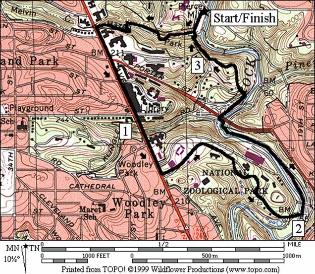
Melvin Hazen/Zoo
(3.25 miles, IV)
This
route has four distinct parts to it. The
first, Melvin Hazen
Park, is a stream valley tributary
to Rock Creek. It’s in a close to
natural state and is one of the few major tributary streams
to Rock Creek under which there is no sewer pipe buried. The main trail in it climbs steeply from Rock
Creek in a stair step fashion past several small cascades. It even goes up and down a little as it makes
four easy stream crossings on stones. At
Connecticut Avenue, a half
mile from Rock Creek and 150 vertical feet higher, the route leaves the trail
and is on the sidewalk. The contrast is
abrupt. The concrete sidewalk on Connecticut
Avenue is almost level, and full of activity. The dirt Melvin Hazen Trail is quiet, shady
and few people visit it. When looking
back at the trail below it appears as does a view of many mountainside
trails. Note that from Connecticut
Avenue, you are only at the mid-point of the
Melvin Hazen Trail. One could continue
through the woods on the other side for another half mile, then
through a connector route, proceed a few city blocks further to the trail head
at the top of Glover Archbold Park. From the Rock Creek hiker-biker trail in the
Rock Creek valley, to Glover Archbold Park,
is a distance of 1.9 miles.
Running
on Connecticut Avenue is
not hard. The sidewalks are wide, the
foot traffic manageable, and the people are friendly. The activity is exhilarating and shows the
nicer side of living in the city.
Pedestrian traffic gets a little busy near the shops and stores at the Cleveland
Park metro station (use this as an
alternate start). Keep one eye on the
shops as you pass by for an eating spot to come back to later. There are many good ones with a few bakeries
too.
The
National Zoo offers a chance to slow down and take in the sites on the way back
to the Rock Creek valley. You can see
some the city skyline from the zoo also.
The grounds are open to the public 5/1-9/15
6AM-8PM, 9/16-4/30 6AM-6PM (admission is free). Go early or late to avoid crowds which can be
thick on nicer days. I observed the
Kangaroo quietly hopping around in the snow one evening at dusk. The Olmstead Walk gently winds its way down
the hillside past major exhibits and is the main way through the Zoo. Water fountains and restrooms can be found
along side it.
Back
inside Rock Creek
Park, take the hiker-biker trail
upstream to just past the underpass for Porter St. Though Porter Street
is not marked from the trail, it’s easily identified by a trestle bridge. The trail uses the trestle bridge to go over
Rock Creek, just before the underpass of Porter St. Cross the parkway exit ramp to Porter
St. to get onto a carriage road which climbs
gently to the front of Kingle
Mansion. Take the driveway to an unpaved trail head
that leads back to Pierce Mill.
|
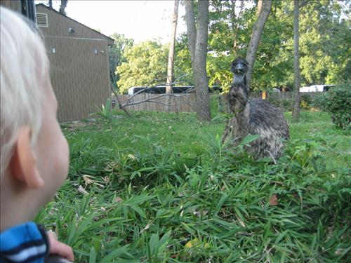
Curious
Human, Curious Emu
|

On
the Asia Trail, a slight detour from the described route.
|
Dumbarton Oaks (6.75 miles, VI)
To
get to Dumbarton Oaks from Pierce Mill, take the Rock Creek hiker-biker trail south
and down stream. On it follow the creek
bends around Kingle
Mansion, the National Zoo, and the
many magnificent arched bridges that span the valley. The bridges show
workmanship in stone and concrete not found in many more modern
structures. Some of them like Taft
Bridge which carries Connecticut
Avenue, gracefully tower a hundred feet
overhead. At Connecticut
Avenue, Beach Drive
ends and the major transportation route through the Rock
Creek Park
is the Rock Creek Parkway. Shortly after crossing the ramp from it to Woodley
Park, the trail dips down to Shoreham
Hill Bridge
to cross the Rock Creek. Instead of
following the trail over the bridge and creek, take the dirt footpath that
stays on the west (right) side of the creek. This is the Parkway Trail. The trail is wide and gently down sloped
until the end of it. Pass the Normanstone Trail on your right which is your return
route. Some of the trees there are 130
years old and little distinguishable from virgin forest. A little further, just before the underpass
for Massachusetts Avenue, a
quarry is visible on the right. There
dark Norite stone, a type of basalt was once sea
bottom. The Norite
underlies much of Georgetown. The quarry provided for the structures built
within the gardens at Dumbarton Oaks.
The Parkway Trail leaves Rock Creek and rises abruptly before ending at
Dumbarton Oaks and Lover’s Lane.
Dumbarton
Oaks is a marvelous little park tucked away in the midst of Georgetown. The formal gardens and mansion can be visited
for a fee. However, Dumbarton
Oaks Park
and the Dumbarton Oaks Trail which passes through it are free, and much
charmed. The Dumbarton Oaks Trail
changes dramatically from one end the other.
Tree covered at first, it resembles some of the formal gardens you must
pay to see. After passing by some
waterworks and crossing the stone bridge, it opens in to a small bowl shaped
field with some wild flowers. Continuing
further uphill the trail is more loosely defined. Bear to the left across the field and away
from the gravel path trailing to the right.
A dirt path passes through wild shrubbery and a swampy section then
climbs a dirt switchback on the left side of the bowl.
The
top of the switchback is the end of the Dumbarton Oaks Trail and also the
beginning/end of Whitehaven Street. Turn right and take the Normanstone
Trail (see the sign) uphill a little further.
The trail skirts a chain-link fence which is on the circular boundary
line of the U.S. Naval Observatory. Many
of the nations’s clocks are keep
in synch by the atomic clock run inside the observatory. This dirt portion of the trail ends near an
entrance gate to the observatory, and continues on the sidewalks of a road (Observatory
Circle is unmarked). Going downhill now, pass the British and New
Zealand Embassies to where Observatory Circle
intersects Massachusetts Avenue. The avenue itself bends at the intersection
to maintain the circle shape of the property line. Cross Massachusetts
Avenue at the traffic light and continue on the dirt trail directly
opposite. The trail is blue blazed and
steeply drops back into the Rock Creek valley.
It again is along roads for a way but blue blazes are visible on telephone
poles to keep you oriented. Keep heading
downhill, bear left when possible until another sign and dirt trail head is
visible. The Normanstone
Trail ends at a T intersection with the Parkway Trail. Turn left and head back up to Pierce Mill the
way you came.
|
|
|

|
|
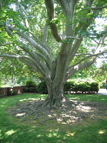
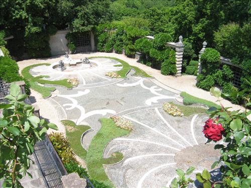
Views
inside the formal gardens of Dumbarton Oaks
Left
Most: Specimin
Beech Tree
Middle:
View from the edge of the Rose Garden.
Right: One of the fabulous roses in Dumbarton Oaks
|
Nearby
and Connecting Zones
What
to do Afterward
Food
and Drink
Firehook Bakery; Cleveland
Park - sandwiches, breads, soup,
outdoor patio (202) 362-2253
Byblos Deli
Cleveland Park
- Mediterranean Cuisine (202) 364-6549
Uno - Cleveland Park
- pizzeria - 202 966-3225
Perry’s
- Adams Morgan - sushi - (202) 234‑6218
Entertainment
and Edification
Pierce
Mill - 202 426-6908
Uptown
Theatre - largest commercial movie screen in Washington
D.C. - 202 333-3456#791
National Zoological Park - 202 673-4800
Kingle Mansion
- on the trail - see Melvin Hazen/Zoo
Washington
National Cathedral - tours - 202 537-6207
Melvin Hazen/Zoo
Distance: 3.25 miles
Rating: IV; unpaved blazed trails,
sidewalks, hiker-biker trails
0.0 from
the parking lot, head south past the restrooms on the grass
R 0.1 Melvin
Hazen Trail (yellow blazes); before wooden bridge; up steep hill
L 0.55 Connecticut
Ave on sidewalk
0.75 Cleveland
Park metro station
L 1.2 Pedestrian
Entrance to the National Zoo; Olmstead Walk open (5/1-9/15
6AM-8PM); (9/16-4/30 6AM-6PM);
closed 12/25
S 1.95 at
parking & over the bridge for Rock Creek
L 2.0 Rock
Creek hiker-biker trail
L 2.65 at
paved trail X on L; after the trestle bridge & underpass for Porter
St; cross the exit ramp coming from the Rock
Creek Parkway
BR 2.7 onto
gravel carraige road; uphill (Do Not Enter sign at
the gate is for cars)
R 2.95 paved
driveway for Kingle
Mansion
R 3.05 unpaved
trail head on right at bend in driveway (not blazed)
BR 3.1 trail
splits
R/L 3.15 R
down steep hill; L
toward wood bridge; Western Ridge Trail
3.2 Melvin
Hazen Trail
3.25 parking
and restrooms
Melvin Hazen/Zoo
Dumbarton
Oaks
Distance: 6.75 miles
Rating: VI; paved and unpaved trails, some
sidewalks
R 0.0 head
downstream, south, from the water fountain on the paved Rock Creek hiker-biker
trail
0.05 Hazen
Bridge over Rock Creek
0.4 Bluff
Bridge over Rock Creek and Western
Ridge Trail on R
0.65 underpass for Porter St
and Kingle Ford
Bridge (trestle) over Rock Cr
1.25 Zoo
entrance on R
1.45 through
gate into Zoo grounds to avoid tunnel; gate is open (5/1-9/15 6AM-8PM); (9/16-4/30
6AM-6PM); closed 12/25
BR 1.9 exit
gate for Zoo grounds
2.0 underpass for Calvert St
(large arch)
2.15 Connecticut
Ave ramp X
R 2.35 Parkway
Trail; just before Shoreham Hill bridge for the Rock Creek Trail
2.5 Normanstone Trail on R (return route)
2.65 Mass
Ave underpass (large arch)
L/R 2.95 at
Lover’s Lane (unmarked); into Dumbarton
Oaks Park
R/L 3.0 over
the stone bridge; follow gravel road up until the open field, cross the field
to a dirt trail on the L side; climb to the switchback and road
R 3.35 Normanstone Trail at Whitehaven St;
follow trail along fence (blue blazes)
BR 3.55 onto
sidewalk for Observatory Circle;
Observatory gate on L
S 3.75 cross
Mass Ave; pick-up the
marked trail head going down into the woods
BR 3.9 Normanstone Dr (follow blue blazes)
L 3.95 onto
Edgevale Terr at 30th
St X
L 4.15 Rock Creek Dr
R 4.15 Normanstone Trail into woods at signed trail head
L 4.25 Parkway
Trail at T
BL 4.4 Rock
Creek hiker-biker trail (paved)
4.6 Connecticut
Ave ramp X
BL 4.85 avoid
tunnel; Zoo grounds gate
5.35 exit
Zoo grounds
5.5 Zoo
entrance on L
6.1 Kingle Ford
Bridge (trestle)over
Rock Cr and underpass for Porter St
6.4 Bluff
Bridge over Rock Creek and Western
Ridge Trail on L
6.7 Hazen
Bridge over Rock Creek
6.75 water
fountain near Pierce Mill parking