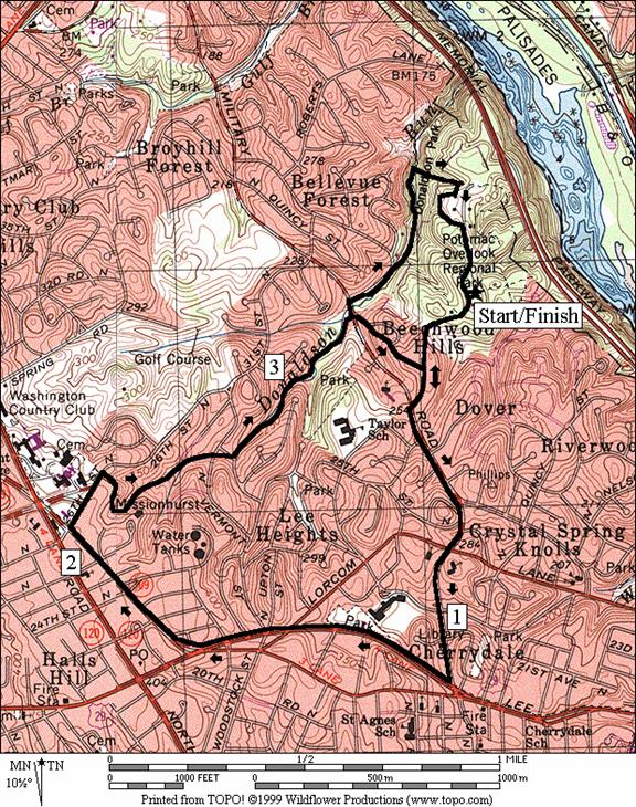
Donaldson Run/Potomac Overlook Regional Park
Potomac Overlook Regional Park, one of
the little known parks in Arlington, sits
perched over the Potomac River in North
Arlington. The hilly natural grounds have a few short trails. They are
frequented by people walking dogs as well as by those who’ve come to watch
submarine races. Though the overlook can be a little disappointing, the park is
worth coming to. You might come across a deer or wander over to the site of a
seasonal Indian camp dating back to 500 AD.
There are gardens and a small Nature Center. Trails
go under the parkway to the river. In
the summer there is also a summer concert series. The Potomac overlook itself
is high enough but in summer the view is partly obstructed by leaves; you can’t
see the river, and the George Washington Parkway’s presence underneath is a
noisy intrusion to an otherwise peaceful setting.
Getting
There
From
Northern Fairfax County, VA; Montgomery or
Northern Prince Georges Counties, MD
Exit the
Capital Beltway near the American Legion Memorial Bridge, onto the
George
Washington
Parkway. After 3.75 miles, take Chain
Bridge Rd. east toward Washington D.C. (second
exit). At the bottom of the hill before the bridge (1.1 miles), turn right at
the traffic light onto N. Glebe Rd. Go 0.3
miles up the hill, and bear right onto Old
Chain Bridge Rd., following the sign toward
Military Rd. Turn left off Old
Chain Bridge Rd. after the overpass, onto Military
Rd. After 1.4 miles, turn left on Marcey Rd.
Follow it to the end, parking at the circle in Potomac Overlook Park. Start at
the trail head to the overlook, near the billboard and gate.
From Southern
Fairfax County, VA or
Southern Prince Georges County, MD
At Alexandria, Virginia, exit the
Capitol Beltway, I-95, northbound onto Rte. 1. Go through the city and bear
right onto Slater Lane after 1.8
miles; just before the Rte. 1 bridge goes over the railroad tracks. After 0.35
miles, turn left onto the George
Washington Parkway. After almost 7 miles, bear
left onto Spout Run Pkwy. Bear
right after 0.65 miles onto Lorcom La. Turn right after 0.85 miles onto
Military Rd. Turn right again after 0.4 miles onto Marcey Rd. Follow it to the
end, parking at the circle in Potomac Overlook Park. Start at
the trail head to the overlook, near the billboard and gate.
Area
Routes
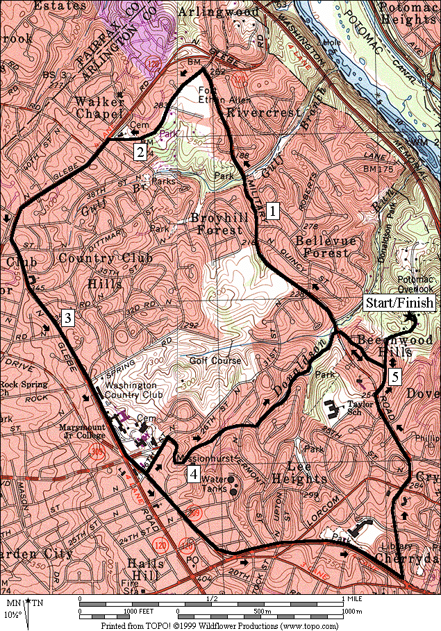
Donaldson Run (3.85 or 4.4 miles,
IV)
The
Donaldson Run Trail goes through a part of Potomac Overlook Regional Park. It can
be followed all the way from Marymount University near N. Glebe
Rd. to the Heritage Trail that goes along the
shores of the Potomac River. The
section from N. Glebe Rd. to Military
Rd. is partly paved, and partly surfaced with
bluestone. It’s wooded and quiet. It drops about 230 vertical feet in less than
1 mile. From Military Rd. to the Potomac
River, the trail is more of a natural surface hiking trail and
continues to drop. It parallels and crosses its namesake creek several times
without bridges as it descends, sometimes steeply toward the river and the
Potomac Heritage Trail. This route first climbs from Potomac Overlook Park on roads
to the top of the Donaldson Run Trail. It then takes the paved/bluestone trail
down to Military Rd. From
there, you have options to use the natural trail or return on roads.
Military Road (5.3 or 6.0 miles, VI)
Military
Road was cut through a forest in the 1860's to connect some of the Battery defense
forts that were built to protect Washington D.C. during
the Civil War. Pricey real estate, now lines the hilly road. On this route,
make a counterclockwise loop starting out by going up and down the hills on Military
Rd. In addition to the houses, pass a golf
course and Glebe Rd. Park. That
park has within it the Gulf Branch Trail, and the Gulf Branch Nature Center. On Old
Chain Bridge Rd., pass Fort Ethan Allen Park,
one of the battery defenses built in 1861. Later pass Glebe Rd. Park again
where water is available. Most of N. Glebe
Rd. is less interesting until you reach Marymount University. The
route on N. Glebe Rd. climbs a
bit. Return on the quieter and shady Donaldson Run Trail (see the Donaldson Run
Trail above) to return to Potomac Overlook Regional Park, or
optionally continue around down Lee Hwy. to Military
Rd.
Nearby
and Connecting Zones
Iwo Jima Memorial
Lewinsville Park
Battery Kemble Park
What
to do Afterward
Food and
Drink
Pasha -
eat like an Egyptian king - 703 528-2126
Queen Bee
- Vietnamese - 703 527-3444
Chesapeake Bagel
Bakery - 703 506-0536
Entertainment
and Edification
Potomac Overlook Nature Center - look
for the summer concert series in Potomac Overlook Park
Gulf Branch Nature Center - off Military
Road - 703 228-3403
Turkey Run
Recreation Area - off the George Washington
Parkway
Donaldson
Run
Distance:
3.85 or 4.4 miles
Rating:
IV; hilly paved and unpaved trails; street sidewalks
3.85
Mile Route
0.0 from the gate on
the road at the circle; take the road to leave the park
0.25 Beechwood
Pl on R
CL 0.35 Military Rd
0.65 Nellie
Custis Dr on L
0.8 Lorcom La
R 1.1 Dominion Dr/Lee Hwy, Rte 29
1.55 Lorcom La
R 1.8 Old Dominion Dr, Rte 309
R 2.25 on
31st St; at 26th/31st
St
R 2.4 Donaldson
Run Trail (water)(paved)
2.8 cross Vernon
St
2.85 Vermont
St
2.95 pavement ends
<*
S 3.35 cross
Military Rd to Beechwood
Pl (steep uphill climb on the road)
BR 3.4 Beachwood Circle
BR 3.45 Beachwood Pl
L 3.6 Marcey Rd
BR 3.8 road
splits in the park
3.85 gate in the
road/parking

*4.4
Mile Route
L/R 3.35 L
on Military Rd; R on 30th
St
R 3.4 Donaldson
Run Trail (on the grass at the end of the sidewalk; before the
fence); cross the steam on stones as necessary; trail is blazed
yellow
3.5 trail X on R
R 3.85 Brown Creeper Connector Trail (unmarked;
after the 5th creek crossing; a
small plank bridge on the trail identifies it; follow brown
blazes; miss the turn an you end-up at the Potomac
River on the Heritage Trail)
R 3.95 Heritage
Loop Trail at top of hill (unmarked; garden and Indian camp
site are S; occasional green blazes)
BL 4.2 trail
X; bear L to the road
R 4.2 Marcey Rd at the Nature Center
4.3 trail X on R
4.4 parking circle at
the gate
Donaldson Run
Military
Road
Distance:
5.3 or 6.0 miles
Rating: VI;
sidewalks through residential neighborhoods and an improved surface trail
5.3
Mile Route
0.0 from the gate on
the road at the circle; take the road to leave the park
R 0.25 Beechwood Pl on R
BL 0.35 Beechwood Circle
BL 0.4 Beechwood Pl
CR 0.45 Military Rd;
Donaldson Run Trail is S
1.15 Gulf Branch Trail;
Nature Center
L 1.6 N Old Glebe Rd
1.7 Fort Ethan Allen
Park
1.95 Glebe
Rd Park (water)
L 2.1 N Glebe Rd
2.65 Williamsburg
Rd on R
BL 3.55 Old Dominion Rd; Marymount University
*<
L 3.7 on
31st St; at 26th/31st
St
R 3.85 Donaldson
Run Trail (water)(paved)
4.25 cross Vernon
St
4.3 Vermont
St
4.35 pavement ends
S 4.8 cross
Military Rd to Beechwood
Pl (steep uphill climb on the road)
BR 4.85 Beachwood Circle
BR 4.9 Beachwood Pl
L 5.0 Marcey Rd
>*
BR 5.2 road
splits in the park
5.3 gate in the
road/parking
*6.0
Mile Route
S 3.7 26th/31st
St on R/L
L 4.15 Lee Hwy, Rte 29
4.4 Lorcom La
L 4.85 Military
Rd; Quincy St is to R
5.2 Lorcom La
5.3 Nellie
Custis Dr on R
R 5.6 Marcey Rd
5.7 Beechwood Pl on L
(pickup cues at mile 5.2 on 5.3 mile route)
Military Road