Belle Haven Park and Marina
South of Alexandria, just off the Potomac River
is Belle Haven, a picnic park and marina.
The area has Scottish roots. In
the 1730's merchants traded tobacco in a warehouse there. The river seems to change character here as
it flows toward the Chesapeake Bay. It widens at the mouth of Cameron Run where
Great Blue Herons and Snowy White Egrets fish on the tidal mud flats. Hydrilla growing in huge mats visible in the
summer, was once a scourge of boaters.
It disappeared in the 1970's but now is a sign of the river’s health
returning. The Dyke Marsh, further south
is now a wildlife refuge where more avian residents such as red winged
blackbirds can be seen. A gravel and
dirt road through a sanctuary south of Belle Haven makes a nice short
out-and-back hike from Belle Haven. The
Mt. Vernon Trail parallels the river and the George
Washington Parkway. The Mt. Vernon Trail was built in 1973. The parkway was completed in 1932. Before either of them people such as Eleanor Roosevelt
used to horseback along the river.
Getting There
From Virginia
on the Capital Beltway
Take Exit 1 headed south on Richmond
Hwy., Route 1.
Once on Route 1, stay in the right lane to take the next exit for Fort
Hunt Rd.
Once on the exit ramp, you’ll need to stay in the left lanes, bearing
left and passing through the traffic light across Route 1 to get onto Ft.
Hunt Rd. After
1.1 miles, turn left at a traffic light near the shopping center onto Belle
View Blvd.
At the end of Belle View Blvd.,
after 0.6 miles turn left on the George Washington
Parkway, and move to the right lane. Turn right into Belle Haven, then immediately
turn left toward parking areas. Start
from the water fountain near the restrooms.
From Maryland
on the Capital Beltway
Be in the right lane when coming over the Wilson
Bridge, and take the first exit
toward Mt. Vernon. The exit ramp actually puts you on Church
St. but at the traffic light you can turn right
onto Washington St. As Washington St.
crosses over the beltway and leaves Alexandria,
it becomes the George Washington Parkway. After 1.25 miles, turn left into Bell
Haven. Immediately turn left again
toward parking areas. Start from the
water fountain near the restrooms.
Area Routes
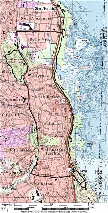
Southdowns
(5.35, 6.05 or 6.3 miles, V, VI, VI)
Following the Mt. Vernon Trail south, the way is initially
flat and more sunny than not. The George
Washington Parkway is visible on the right and
Dyke Marsh lies hidden behind the trees to the left. As you go further however, a long wooden
bridge carries you over part of Dyke Marsh across it’s major waterway. On the other side the trail remains flat but
is wooded and shady. A view of a
lagoon-like area the river opens up to the left just before a long and gradual
hill begins. The paved trail runs out
before reaching the top. The route and
the Mt. Vernon Trail is then on the quiet Northdowns Rd. Finally reaching the top at the stone bridge
for Alexandria Ave. on
the right, one option is to leave the Mt. Vernon Trail (water is available
if you go 0.09 miles further on the Mt. Vernon TrailBcourtesy
of the Road Runner’s Club of America in 1994) and go straight on to Southdowns
Rd. That
way makes a small loop by going downhill past several houses and along the
river back to Northdown Rd. The road becomes gravel at one point. Glimpses of the river can be seen here, but
private properties prevent you from getting to the shore for a good view. Once you reach Northdown
Rd. turn right and return on the Mt. Vernon
Trail.
Going right to cross the stone bridge over the parkway, also
leave the Mt. Vernon Trail for the road just ahead. A large loop back along Ft.
Hunt Rd. and the Paul Spring Branch can be
made. The loop is on a mostly paved
trail but it’s not nearly as nice nor smooth as the Mt. Vernon Trail. It stays close to Ft.
Hunt Rd. but is good for a change if you’re tired
of out and back’s on the Mt. Vernon Trail.
The trail goes on sidewalks for a short way before becoming surfaced
with bluestone at Mt. Vernon
District Park. In this park, another optional extension is
available. This extension can be
somewhat hard to follow however. There
are some white blazes for a dirt trail but parts of it don’t get a lot of use
and are rough. On the extenstion, a
steep downhill on a second easier to follow dirt trail returns you to the
bluestone trail along Ft. Hunt Rd
again. Just before leaving the park area
for either route, you will pass a public ice rink at the bottom of the hill
that is occasionally used by the Washington Capitals ice-hockey team for
practice. Use the flat sidewalk along Belle
View Blvd. to get to the Mt. Vernon Trail
again. The only obstacle on that leg of
the route is crossing the George Washington Parkway
at the end of Bell View Blvd. There’s no traffic light but crossing is not
too bad if you’re patient enough to wait for a break.
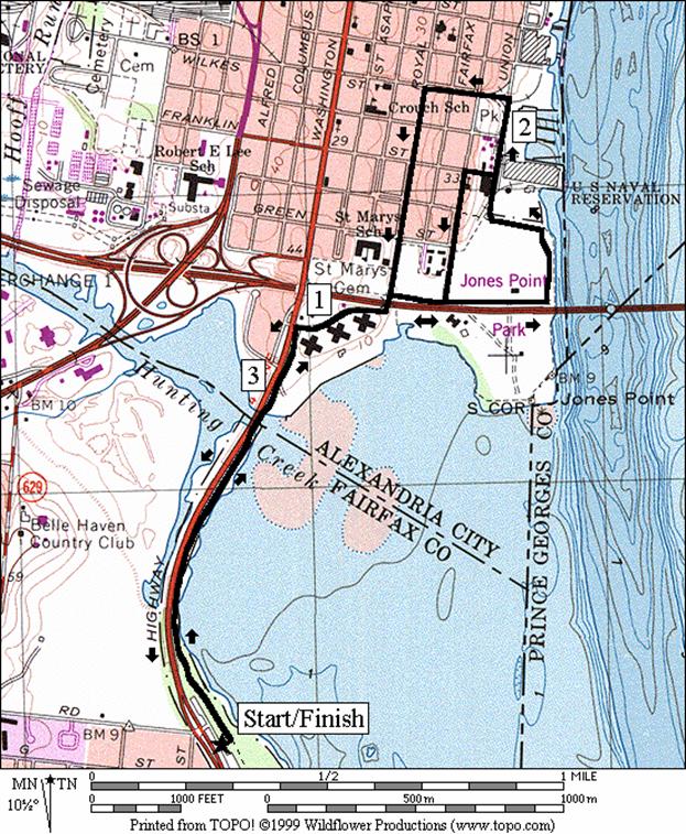
Jones
Point (3.7 or 3.55 miles, II)
Look across the water to your left before you start this
route and you’ll see part of your destination.
Heading north, the Mt. Vernon
trail is on a flat sliver of land that curves along a cove of the
riverbank. It’s often breezy here in the
wintertime but hot and somewhat stagnant during the day in the summertime as
the heat rises off the water. For part
of the stretch, there are no trees.
In-line skaters enjoy it just about any time though it’s not long before
you reach the Alexandria city
limits. The municipal border, on the
stone bridge crossing over Cameron Run, is a popular place with birders. They setup spotter scopes on the vantage the
bridge provides. After passing the
condominiums the paved trail runs out.
Use the sidewalk along South Street
and cross under the Capital Beltway.
Major renovations are expected here as the Wilson
Bridge is rebuilt. Much of Jones
Point Park,
the southernmost point of Washington, D.C. may lost. The federal lighthouse in that park was built
in 1790 and operated until 1856. Cadwalader Jones, for whom the area is named
for, had built a cabin there in 1692.
Because of the bridge construction, the way through may be much
different than it is in the year 2000, at the time of this writing, but one
positive side of it is that a hiker-biker path is planned for the bridge to
cross into Maryland. As it is, just as you cross under the
beltway, turn right on Jones Point Rd. Jones Point Rd.
is quiet but has an industrial feel to it.
The route gets better when you turn left on the paved Mt. Vernon
Trail, just before hitting the river.
The trail leaves the river quickly however, and soon ends again after
passing more woods on the left, with the back yards of houses on the right. A short option turns uphill on Franklin
St. then uses Lee St.
to return to Jones Point Rd. Going on into the city a little further, turn
left on the Cameron Run Trail through a tunnel for an old railway. Return on Royal St.
sidewalks, crossing back under the beltway, and back on the paved
Mt. Vernon Trail to Belle Haven.
Nearby and Connecting Zones
What to do Afterward
Food and Drink
Brenner’s Bakery Bellview Alexandria - some of the best
cookies around Washington, D.C.
- 703 765-4688
Krispy Kreme Doughnut Co. - an old time favorite - 703
768-0300
Outback Steakhouse - 703 768-1067
Sutton Place
- gourmet foods in Old Town Alexandria - 703 549-6611
Chin’s Kitchen - tasty Chinese carryout food - 703 765-4600
Dishes of India
- 703 660-6085
Entertainment and Edification
Dyke Marsh - for a warmdown hike out and back through the
bird sancturary
Mt. Vernon Recreation Center-Ice Rink & Pool - 703
768-3224
Stone
Mansion and Stoneybrooke
Park - home of a friend of George
Washington built this home in 1777 - 703 938-8835
Gadsby’s Tavern Museum
- 703 838-4242
Collingwood Library & Museum - 8301 E Boulevard Dr, Alexandria,
VA - (703) 765‑1652
American Horticultural Society - 8:30AM-5:30PM Mon-Fri - 703 768-5700
Southdowns
Distance: 5.35, 6.05 or 6.35 miles
Rating: V, VI, VI; shaded paved trails with suburban
streets and sidewalks; some hills
5.35
Mile Route
L 0.0 south
on the Mt Vernon Trail (MVT) from the water fountain/restroom
0.15 cross
the marina road
0.4 Belle
View Blvd on R
0.75 begin
long wooden bridge; Mile 7
1.0 parking;
West Grove Blvd (phone)
1.55 begin
wooden bridge at lagoon
2.2 trail
ends; begin Northdown Rd
2.35 Southdown
Rd on L
<*
S 2.45 Southdown Rd;
MVT goes R on Alexandria Ave (stone bridge)
2.55 Kent
Rd on R
BL 2.95 to
Northdown Rd at sign
R 3.0 Northdown
Rd (MVT)
3.15 MVT
head at end of Northdown Rd
3.75 end
wooden bridge at lagoon
4.35 parking;
West Grove Blvd (phone)
4.65 Mile
Marker 7 after long bridge
5.0 Belle
View Blvd on L
>*
5.2 cross
the marina road
5.35 water/restrooms;
Belle Haven Park and Marina

*6.05
Mile Route
R 2.45 Alexandria
Ave bridge over pkwy
S 2.45 MVT
goes L after stone bridge; (water to L 0.05 miles) use shoulder
2.95 cross
Ft Hunt Rd (!)
R 3.0 Paul
Springs Pkwy
L 3.15 paved
trail along Ft Hunt Rd
3.4 Sherwood
Hall La/Morningside La
3.95 Pauls
Spring Rd on L
4.25 Quander
Rd on L
<**
4.4 trail
X on L (unmarked/unpaved) before steep downhill
4.8 trail
X on L (unmarked/unpaved) before small wooden bridge
>**
R 5.05 Belle
View Blvd
CL 5.65 cross
GW Pkwy onto MVT (pickup cues at mile 5.2 on 5.35 mile route)
**6.3
Mile Route
L 4.4 trail
X on L (unmarked/unpaved) before steep downhill
L 4.45 at
T; follow occasional white blazes
4.5 trail
X on R
4.6 trail
X on L
R 4.6 trail
X on R; S is to road
4.8 cross
the gully (!); then BR to follow the white blazes
BR 4.9 go
S at first X; then BR down the hill
5.0 trail
X L&R
L 5.1 at
T; trail along Ft Hunt Rd (pickup cues at mile 5.05 on 6.05 mile route)
Jones Point
Distance: 3.7 or 3.55 miles
Rating: II; paved flat trails and some street
sidewalks; mostly flat and sunny
3.7
Mile Route
0.0 north
on the Mt Vernon Trail (MVT) from the water fountain/restroom
0.75 stone
bridge over Cameron Run; Alexandria city limit
R 0.95 South
St; use sidewalk
L 1.15 Royal
St goes under the Capital Beltway, I-95
R 1.2 Jones
Point Rd
1.3 Lee
St (unmarked gravel road) on L
1.35 road
to Jones Point lighthouse on R
L 1.5 paved
trail head (MVT) at Potomac River=s
edge
R 1.85 paved
trail ends, use Union St
<*
1.9 Franklin
St on L
L 2.05 Cameron
Run Trail head on L goes into tunnel
L 2.2 Royal
St; use sidewalk
2.5 Jones
Point Rd on L; go S under the Capital Beltway, I-95
>*
R 2.55 South
St; use sidewalk
L 2.75 trail
head (MVT) before Washington St
2.95 stone
bridge over Cameron Run; Fairfax County border
3.7 water
fountain/restrooms; Belle Haven Park and Marina
*3.55
Mile Route
L 1.9 Franklin
St; short steep uphill
L 1.95 Lee
St (becomes gravel before next turn)
R 2.25 Jones
Point Rd
L 2.35 Royal
St (pickup cues at mile 2.55 on 3.7 mile route)