Tucker Road Community Park/Henson Trail
Southern Prince Georges
County has few paved trails that
people can run or ride on. The six mile
long Henson Trail goes northeast to southwest following Henson Creek from Temple
Hills Road to Oxon Hill
Road. It is
the only major trail in the area. At its
center, it passes through the Tucker Road
Community Park
which is maintained by the Maryland National
Capital Park
and Planning Commission (M-NCPPC). The Tucker
Road Community Park
has a fitness trail, an ice rink, basketball courts, tennis courts, ball
fields, a playground and a fishing pond.
Basketball is played very intensely here. The Henson Creek golf course is just north
off Tucker Road. A small paved trail and a twisting inner
extension, loops the fishing pond.
Complete loops around the fishing pond and part of the ball fields are 0.57
and 0.68 miles long respectively.
The Henson Trail has many isolated sections far from
intersecting roads. For this reason, it
is worth visiting however extra care for safety should be applied. Though I saw some women who seemed
comfortable traveling alone on the trail, traveling in pairs or groups is
recommended.
Getting There
From the Capital Beltway (I-95), take Indian
Head Highway, Rte. 210, south. Turn left at the first light onto Livingston
Road. After
1.4 miles bear right onto Saint Barnabas Road
as Livingston Road bears
left. Turn right almost immediately onto
Tucker Road after getting
on Saint Barnabas Road. Turn left after one mile into the Tucker
Road athletic complex parking. The trail head is on the right, just past the
building.
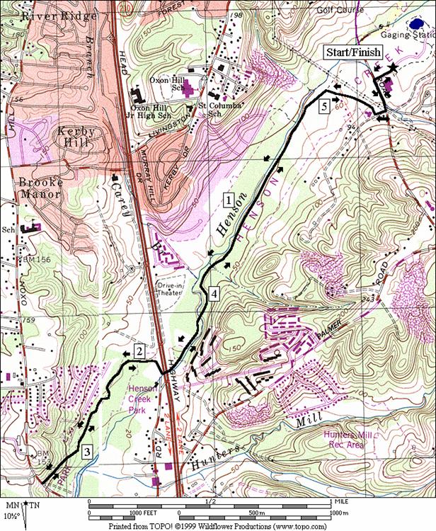
Area Routes
Oxon Hill Road
(5.55 miles, IV)
After leaving the athletic complex and passing a community
center, the trail enters a long wooded section.
It parallels Henson Creek=s
downward flow. Only occasionally are there
glimpses of the creek however. Some
places may also have standing water on the trail after big rains. The trail eventually crosses Henson Creek, then crosses under Indian Head
Highway with the creek. Be careful at the highway bridge because
there are blind corners and young kids often play there. The trail becomes flatter as it passes
through a community park, then it turns up for the only real hill, just before
ending at Oxon Hill Rd. From there, turn around and come back the way
you came.
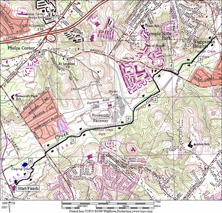
Temple Hill Road
(6.5 miles, V)
Going northeast along Washington Suburban Sanitary
Commission buried pipeline, the Henson Trail passes through several small parks
and crosses a few roads. It is pleasant
most of the way. The trail to Temple
Hill Road from the Tucker
Road Community Park
is more open than the going from Oxon Hill Road
to the community center park is, but the uphill grade from Tucker
Road Community Park
to Temple Hill Road is
slightly more noticeable. Measured mile
markers start counting down every quarter mile for two miles once you leave the
Tucker Road
Community Park
area. The zero mile mark is in the
middle of the Henson Trail at Brinkley Road,
not the end of the trail at Temple Hill Road. The trail passes very close to Rosecroft Raceway but the raceway is on the opposite side
of Henson Creek and is not visible. At Brinkley
Road, one must briefly use the narrow shoulder of
the sometimes busy roadway. The final
segment to Temple Hill road is nice but not exceptional. Once there, turn around and return the way
you came.
Nearby and Connecting Zones
Fort Washington
Park
Louise F.
Cosca Regional Park
What to do Afterward
Food and Drink
Picnic
Entertainment and Edification
Fort Washington
Visitor Center
- 301 763-4600
Oxon Hill Farm - 301 839-1177
Rosecroft Raceway - horse racing -
301 567-4000
Oxon
Hill Road
Distance: 5.55 miles
Rating: IV; out and back on a paved, wooded stream
valley hiker-biker trail
0.0 from
the fitness trail head, go toward Tucker
Rd
CL 0.05 Tucker Rd
R 0.2 Ferguson
La
0.25 Tucker Rd
Community Center driveway
0.35 trail
head at end of parking lot
0.75 trail
X on R to wooden bridge
1.5 sharp
bend in trail to L
1.7 wooden
bridge over Henson Creek
1.9 underpass
Indian Head Hwy (! blind
corners)
2.3 trail
X at community park
U 2.8 Oxon Hill Rd
3.25 trail
X at community park
3.6 underpass
Indian Head Hwy (! blind
corners)
3.9 wooden
bridge over Henson Creek
4.05 sharp
bend in trail to R
4.8 trail
X on L to wooden bridge
5.2 Tucker
Rd Community Center parking lot
L 5.3 Ferguson
La
L 5.35 Tucker Rd
R 5.5 into
Tucker Rd Community Park parking lot
5.55 trail
X on R (fitness trail)
Temple Hill Road
Distance: 6.5 miles
Rating: V; out and back on a paved, wooded
stream valley hiker-biker trail
0.0 from
the parking lot, follow the fitness trail
0.1 trail
X on L; go S between ballfields 3 & 4
R 0.4 R
on service road
BL 0.45 trail
head on L leaves service road; Mile Mark 2
L/R 0.6 park
road before crossing Bock Rd
(unmarked)
0.9 Mile
Mark 1.5
2.1 wooden
bridge over Henson Creek
CR 2.4 Brinkley
Rd (! use sidewalk, then narrow shoulder)
L 2.6 WSSC
service road
2.65 trail
head
3.2 trail
X on R to parking
U 3.25 Temple Hill Rd
3.3 trail
X on L to parking
3.85 trail ends; use service road
R 3.9 Brinkley
Rd (! use narrow shoulder, then sidewalk)
L 4.1 trail
X on L (!)
4.4 wooden
bridge over Henson Creek
5.1 Mile
Mark 1
L/R 5.9 cross
Bock Rd and turn L on park
road; turn R at trail head on R
6.05 trail merges with service road
L 6.1 trail
X on L; R is to fishing pond loop
6.4 trail
X on R to wooden bridge
6.5 parking
lot
Temple
Hill Road