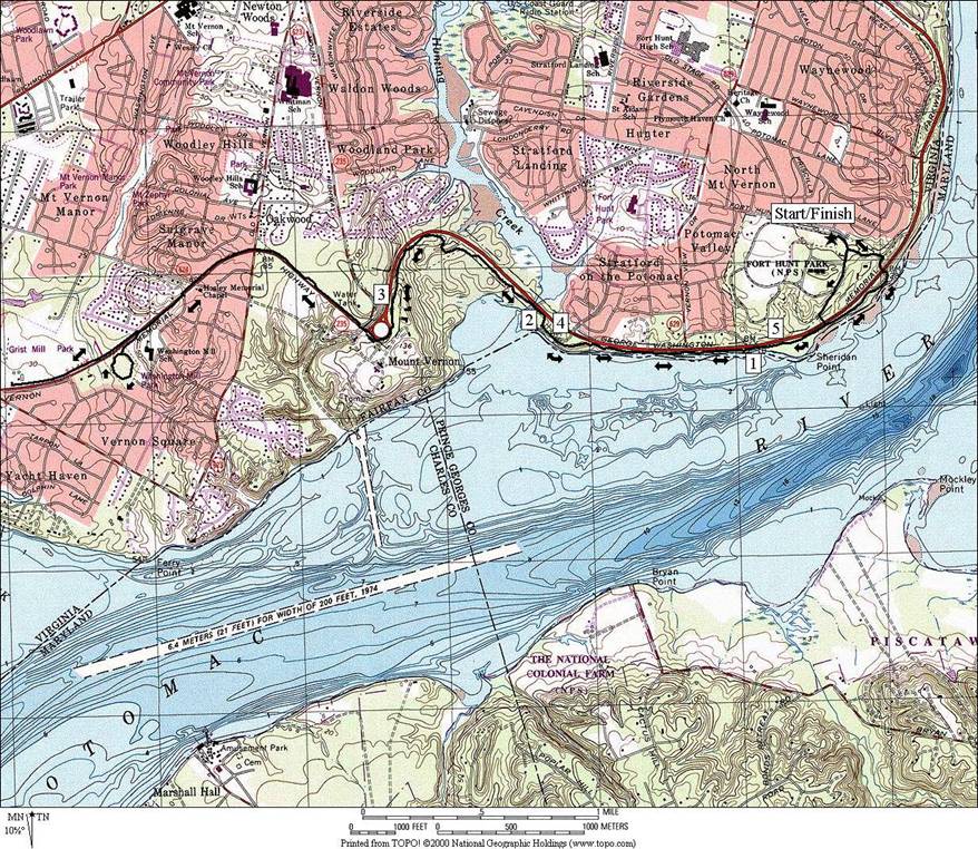
Fort Hunt Park
We have a federal budget surplus to thank for Fort
Hunt Park,
which is two miles north of Mount Vernon,
President George Washington=s
home. In 1890 the excess funds were set
aside for coastal defenses. The existing
Fort Washington
across the Potomac River in Maryland
was strengthened with artillery batteries and new land. Some were built in what is now Fort
Hunt Park. The batteries were designed to remain hidden
and to launch artillery over the trees onto the river. The aim was guided by spotters who would
relay commands. Even though the
batteries were near a quarter mile from the river bank, the artillery of the
day could shoot completely across the river from both sides. Today
Fort Hunt Park
is a quiet place. A bustle of activity
can sometimes be found on summer and spring weekends near the pavilion however,
when company parties, high school reunions, and every day picnickers come. Besides restrooms and the pavilion, few other
amenities are in the park. Fort
Hunt High School
cross country meets were once held here and road races still are.
The park, maintained by the National Park Service, is mostly
flat. Most of a loop road in it is one
way traffic; the inner lane of the one way section is closed to traffic. Cyclists train on it regularly since you can
safely go faster there than on the busier more narrow and winding
Mt. Vernon Trail. The loop road is
good for in-line skaters too however debris after storms or anytime in the fall
can pose a hazard. Some small hills and
most of the trails in the park are along the east and south borders, near the
river. The trails are not marked but
most are easy to follow. None are paved
but some are on gravel roads. There are
several easy access points to the paved Mt. Vernon Trail which goes along
the Potomac River.
The Mt. Vernon Trail can be followed north 15 miles to Rosslyn. From the front entrance of Ft. Hunt
Park to the parking lot at Mt. Vernon
is 2.72 miles. A paved trail can be
followed even further, another two miles past Mt. Vernon
to Grist Mill
Park.
Getting There
From Virginia
on the Capital Beltway
Take Exit 1 headed south on Richmond
Hwy., Route 1.
Once on Route 1, stay in the right lane to take the next exit for Fort
Hunt Rd.
Once on the exit ramp, you=ll
need to stay in the left lanes, bearing left and passing through the traffic
light across Route 1 to get onto Ft. Hunt Rd.
After 0.7 miles, turn left at a traffic light onto Belle
Haven Rd.
At the end of Belle Haven Rd.,
half a mile later, turn right on the George Washington
Parkway. Go
4.6 miles, then turn right toward Ft.
Hunt Park
and Old Ft. Hunt Rd. Bear left into the park at the turn-off for Old
Ft. Hunt Rd. on the right. Turn right at the T-intersection, with the
park loop road. Turn left again almost
immediately and start from the Area A parking lot, near the pavilion.
From Maryland
on the Capital Beltway
Be in the right lane when coming over the Wilson
Bridge, and take the first exit
toward Mt. Vernon. The exit ramp actually puts you on Church
St. but at the traffic light you can turn right
onto Washington St. As it crosses over the beltway and leaves Alexandria,
it becomes the George Washington Parkway. After 5.7 miles, turn right toward Ft.
Hunt Park
and Old Ft. Hunt Rd. Bear left into the park at the turn-off for Old
Ft. Hunt Rd. on the right. Turn right at the T-intersection, with the
park loop road. Turn left again almost
immediately and start from the Area A parking lot, near the pavilion.
Area Routes
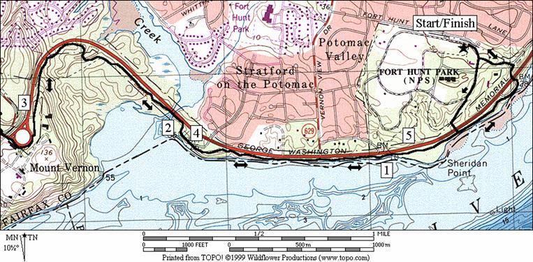
Fort Hunt Park Loop Roads (1.2,
1.6 or 1.45 miles, I)
The park loop road is 1.22 miles around. Runners, walkers and cyclists use it often to
work-up to a distance that they are comfortable with training at. By staying on a shorter loop, they do not
risk getting too far from water, restrooms or their car. This route shows two options to extend the
basic loop. The first is on a paved loop
road extension. In recent years the
extension has been closed to auto traffic.
The second is on a gravel road that sometimes can be wet. When training in on it in my younger years
with friends, we had contests while doing intervals in the rain. The winner was the muddiest and always the
one who fell.
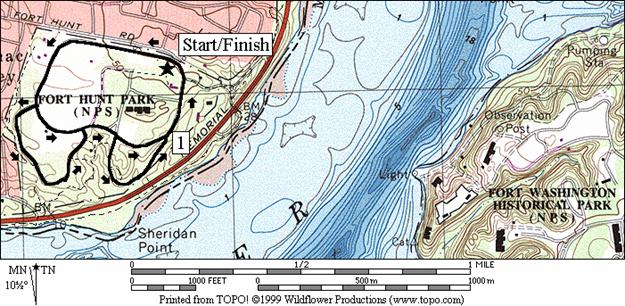
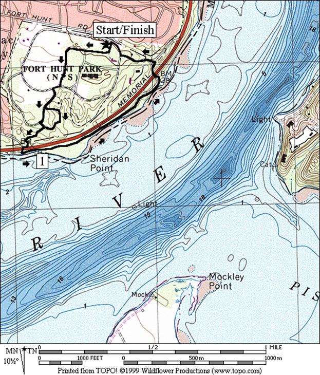
Sheridan Point (1.95 or 1.85
miles, II)
Using the service road that runs through the open middle of
the park, to get onto the outer extension of the park loop road. Turn left on one of two dirt trails (no
bicycles), and reach the river near the intersection of the George
Washington Parkway and River
Farm Dr.
The Potomac River, wide and flat here, makes a
gradual turn forming Sheridan Point as you head north. The Mt. Vernon Trail is tree covered at
first as you wind through some wetlands.
Look for wild yellow irises blooming at the end of May. They can be seen from a wooden bridge before
you reach a water fountain. Going on,
gently climb with good views of Fort Washington
across the river. Come-into Fort
Hunt Park
through the main entrance.
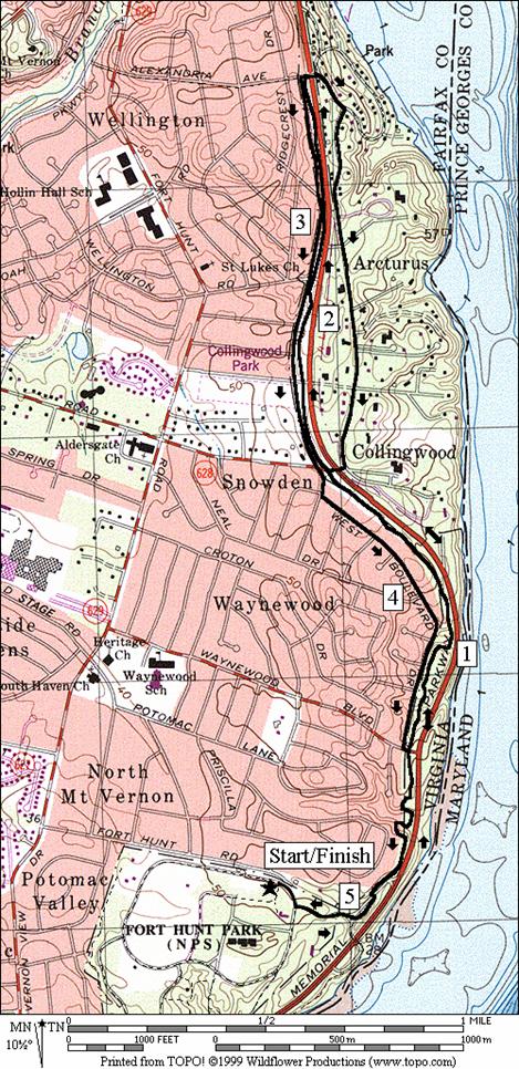
East/West Boulevard (5.2 or 5.3 miles,
IV)
The way north of Fort
Hunt Park
on the Mt. Vernon Trail is slightly hilly at first. The trail is away from the river and it cuts
across the watershed drainage that empties into the Potomac. There is plenty of shade however. At some points hilltop views do open-up to Fort
Washington and other parts of Maryland. People often gather at these to watch
fireworks over the fort during the Forth of July
holiday. Going on you will pass Collingwood
Rd. The trail
flattens out somewhat for the next mile.
Before Alexandria Ave.
is a water fountain that was installed in 1994 by the Road Runner=s Club of America. Coming back, some runners and cyclists prefer
to use West Boulevard Dr. Perhaps it=s a habit. Most of the Mt.
Vernon trail was built in 1973 but
the two mile section of the Mt. Vernon
trail along West Boulevard Dr. wasn=t
built until around 1978. West Boulevard
Dr. is quiet, sunnier and slightly less hilly than the trail. Another option for a return is to cross the
stone bridge over the parkway on Alexandria Ave.,
and return on East Boulevard Dr. This
road is even quieter than West Boulevard Dr.
At Collingwood Rd., cross back over the parkway to the Mt. Vernon Trail,
and return. A third option as with any
of the routes in this guide is simply to go out-and-back.
Mount Vernon (5.9, 5.7, 9.7 or 10.2
miles, VI, V, X or X)
One of my favorite runs is the out-and-back trip to Mt.
Vernon on the Mt. Vernon Trail. Leave
Fort Hunt Park
out the entrance gate or on a dirt trail and carefully cross the George
Washington Parkway. Once on the Mt. Vernon Trail great views of
the river and Maryland can be
seen. If you look carefully, glimpses of
Mt. Vernon
can be seen too. The land across the
river from Mt. Vernon
is Piscataway Park. Behind it, the view is protected by a scenic
easement (lobbied for to ensure the view from Mt.
Vernon remains true to
history). Flat at first, the
Mt. Vernon Trail rolls up and down bluffs overlooking the water and is
only partially shaded. After crossing
Little Hunting Creek on a stone bridge for the George
Washington Parkway, it gets more shaded for the
next mile. None of the hills are notably
difficult compared to other average hills in the Washington
area. The last one however, just before
reaching the Mt. Vernon
parking lot, is the toughest. The
steepest section of that hill was graded and straightened in the 1990's (only
90 ft. over half-a-mile). If you=re in-good shape you=ll run past the average cyclist who is
trying to ride up it. Most people prefer
to simply go out and back to Mt. Vernon
but if you go on, you can continue on a paved trail for another two miles. One option included here goes to Washington
Mill Park,
where you can make a loop on a small unpaved trail. Another option goes further to Grist
Mill Park
where the trail simply ends.
Nearby and Connecting Zones
Belle Haven Park and Marina
Jackson M. Abott Wetland Refuge/Fort Belvoir
Fort Washington Park
Piscataway Park
What to do Afterward
Food and Drink
Cedar Knoll Inn on the Potomac Restaurant - 703 799-1501
Village Warf Restaurant - 703 765-0661
Entertainment and Edification
Mount Vernon -
George Washington=s home -
202 780-2000
Grist Mill
Park - off Mt.
Vernon Memorial Hwy., Rte. 235 near Route 1
Huntley Meadows
Nature Center
- (703) 768‑2525
Gum Springs Historical Society - 8100
Fordson Rd, Alexandria, VA
- (703) 799‑1198
Fort Hunt Park Loop Roads
Distance: 1.2, 1.6 or 1.45 miles
Rating: I; flat, paved, partly shady park roads;
gravel road through woods on the extension
1.2
Mile Route
0.0 go
counterclockwise on the park loop road from Area A parking
0.35 stables/ranger
station on R
<*
0.55 park
loop extension road on R
0.7 park
loop extension road on R
>*
0.75 service
road on L
<**
0.85 service
road; L & R (R is Area E-6 B
unmarked)
1.0 trail
X on R (gravel road)
>**
1.15 park
exit road on R
1.2 Area
A parking
*1.6
Mile Route
R 0.55 park
loop extension road on R (gate)
0.65 trail
X on R (unmarked)
0.85 trail
X on R toward River Farm Dr
0.95 gravel
service road on R
R 1.1 at
T; park loop road (pickup cues at mile 0.75 on 1.2 mile route)

**1.45
Mile Route
R 0.85 service
road (gravel) (R is Area E-6 B
unmarked)
1.05 trail
X on R toward GW Pkwy and
Mt. Vernon Trail
R 1.2 park
loop road (pickup cues at mile 1.15 on 1.2 mile route)
Sheridan Point
Distance: 1.95 or 1.85 miles
Rating: II; gravel roads, dirt and paved
trails, moderate hills & good river views
1.95
Mile Route
0.0 from
the park loop road at Area A, head toward the pavilion
BR 0.05 on
the gravel service road through the row of trees
R/L 0.4 R on
the paved park loop road; L at next X to outer the extension
0.45 driveway
on L
<*
L 0.55 gravel
road on L goes down steep hill
0.6 trail
on L merges (triangle)
R 0.65 trail
X on R goes up hill
0.8 trail
X on R from park road (! sticker bush ahead in summer)
>*
0.8 trail
X on R
0.85 trail
X on R
R/L 0.9 emerge
from woods; R toward River Farm Rd;
cross GW Pkwy; L on Mt
Vernon Trail
1.25 water
fountain
1.3 xwalk
on L (across grass) goes to trail into Fort
Hunt Park
1.65 tunnel
under GW Pkwy on road (!
limited sight)
L 1.75 at
water fountain; use the road to go into Fort
Hunt Park
1.8 entrance
gate into Fort Hunt
Park
R 1.9 park
loop road at T
L 1.95 into
Area A parking

*1.85
Mile Route
S 0.55 gravel
road on L goes down steep hill
L 0.65 trail
on L (unmarked/dirt)
R 0.7 trail
X at T (pickup cues at mile 0.8 on 1.95 mile route)
East/West Boulevard Drive
Distance: 5.2 or 5.3 miles
Rating: VI; paved trails and roads, some
hills & a few good river views
5.2
Mile Route
R 0.0 from
the park loop road at Area A, go clockwise on the park loop road
L 0.05 park
exit road on L
L 0.2 Mt
Vernon Trail (MVT)(water fountain)
0.3 cross
exit ramp from GW Pkwy
0.7 Waynewood Blvd
1.6 Collingwood Dr
2.1 Wellington Rd
<*
UL 2.6 Alexandria
Ave at T (water); UL onto West Blvd Dr
3.15 Wellington Rd
S 3.65 cross
Collingwood Dr; West Blvd
Dr becomes Ashwood Dr
L 3.7 West Blvd Dr
L/R 4.5 L on
Waynewood Blvd; R on MVT
4.9 cross
GW Pkwy exit ramp
>*
R 5.0 at
water fountain; use road to go into Fort
Hunt Park
5.05 entrance
gate into Fort Hunt
Park
R 5.15 park
loop road at T
L 5.2 into
Area A parking
*5.3
Mile Route
R 2.6 Alexandria
Ave at T (water); stone bridge over GW Pkwy
R 2.65 Southdown
Rd; leave MVT
R 2.75 Kent Rd
2.95 Kent
Rd becomes East Blvd Dr
R 3.65 Collingwood
Rd; cross GW Pkwy (!)
L 3.7 Mt
Vernon Trail
4.6 Waynewood
Blvd (pickup cues at mile 5.0 on 5.2 mile route)
East/West
Boulevard Drive
Mount Vernon
Distance: 5.9, 5.7, 9.7 or 10.2 miles
Rating: VI, V, X or X; paved trails, moderate
hills & good river views
5.9
Mile Route
R 0.0 from
the park loop road at Area A, go clockwise on the park loop road
<*
L 0.05 park
exit road on L
R 0.2 Mt
Vernon Trail (MVT)
0.3 tunnel
under GW Pkwy on road (!)
0.65 GW Pkwy xwalk on R
(across grass)
>*
1.05 parking
at River Farm Dr; Mile
Marker 2
1.9 parking
on R at Riverside Park
(outhouses)
2.0 begin
stone bridge over Little Hunting Cr
2.9 wall
at top of hill
<**
U 2.95 parking
lot
>**
3.0 wall
at top of hill
3.9 end
stone bridge over Little Hunting Creek
4.0 parking
on L at Riverside Park
(outhouses)
4.85 parking
at River Farm Dr; Mile
Marker 2
5.25 GW
Pkwy xwalk on L (across grass)
5.6 tunnel
under GW Pkwy on road (!)
L 5.7 at
water fountain; into Fort Hunt
Park
R 5.85 park
loop road at T
L 5.9 into
Area A parking
*5.7
Mile Route
S 0.05 park
exit road on L
L 0.2 trail
X on L (unmarked/dirt)
L 0.35 trail
X on L; cross GW Pkwy at
crosswalk
R 0.45 Mt
Vernon Trail (pickup cues at mile
1.05 on 5.9 mile route)
**9.7
Mile Route
S 2.95 trail
ends at parking lot
R/L 3.1 at
end of parking lot (water); around circle
XS 3.25 at Mt
Vernon Hwy, Rte 235
3.85 Old Mt Vernon Rd
XS 4.15 at Old
Mill Rd
<***
BL 4.5 trail
X on L (dirt/unmarked) before paved trail crosses road at Southwood
Dr
L 4.65 trail
X (sharp L;gravel); Washington Mill
Park
R 4.75 trail
X before road
BL 5.05 trail
X on L (loop is complete; head back)
S 5.15 paved
trail along Mt Vernon Mem Hwy
>***
XS 5.5 at Old
Mill Rd
5.8 Old Mt Vernon Rd
XS 6.4 at Mt
Vernon Hwy, Rte 235; around circle
R/L 6.55 into
parking lot (water)
6.75 Mt
Vernon Trail head (pickup cues at mile 3.0 on 5.9 mile route)
***10.2
Mile Route
XS 4.5 cross
road at Southwood Dr; use shoulder; trail X on L (dirt) before crossing
4.65 trail
head at Peartree Landing
U 5.1 Grist
Mill Park parking
5.55 trail
ends at Peartree Landing; use shoulder
XS 5.65 at Southwood
Dr to paved trail; trail X on R (pickup cues at
mile 5.5 on 9.7 mile route)
Mount
Vernon
(Mount
Vernon detail)