Piscataway Park
The next time you stand at Mt. Vernon,
Virginia and look out across the river,
rest assured that the view won=t
be changed too much. Picataway
Park, maintained by the National
Park Service is what you see. Behind the
park is a vast scenic easement that requires the privately owned land to remain
wooded even though there are houses built there. This portion of southern Maryland
is different from other suburbs around Washington,
D.C.
The pace of life is slower, maybe nicer.
You=re more
likely to run into someone here who will talk to you about fishing, barbeque or
racing than you will find someone talking about e-investments, college
placements, or mega-malls. The park is
the also the location of the National Colonial Farm where guided tours are
offered. When you=re done with the run or hike, stand on
the pier at Bryan Point
in Piscataway Park. Look across the water and you=ll see the best panoramic view there is
of Mt. Vernon.
Getting There
From the Capital Beltway (I-495), take Indian
Head Highway, Rte. 210, south. Turn right after 9.5 miles onto the exit ramp
following the sign toward Bryan Point Rd. Bearing left at the next intersection, the
road will turn right sharply and become Bryan Point
Rd. Park
after 3.6 miles at the end of the road.
Area Routes
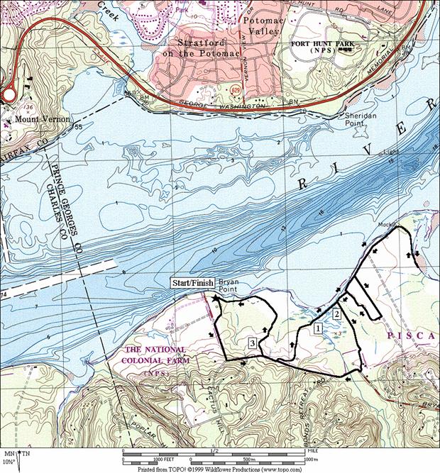
Mockley Point (3.65 or 4.95
miles, II or III)
Soft flat and uncrowded trails along the Potomac
River are the attraction for this route. The route initially follows Bryan
Point Rd. the way you drive in. Turning left on a gravel road, come back to
the Potomac River.
A two-tenth of a mile long wooden bridge takes you over wetlands that
empty into the river. Good views of the
river and Mt. Vernon
can be seen from the walkway. Make a
small loop around a farm field at Mockley Point Rd.
or extend the route with an out-and-back option that passes near Mockley
Point. The return uses dirt trails
(after rains this area is muddy) to pass around the wetlands. A short stretch on Bryan
Point Rd. is finished at the turn-off for the
Robert Ware Straus Ecosystem Farm. The
farm serves as a demonstration area for low impact and organic farming. Solar cells are used to irrigate fields and
crops are planted in combinations that naturally provide pest protection. The produce is sold locally. The sign at the turn-off for the farm from Bryan
Point Rd. indicates that it is a service road
only. Foot traffic is welcome however.
Finally, the Pumpkin Ash Trail goes through a small patch of woods to
the colonial farm and parking.
What to do Afterward
Food and Drink
Sam=s
Crab House - 301 868-4373
B&J Carry-Out - Dixie Style Bar-B-Q - 301 292-5631
Entertainment and Edification
National Colonial Farm
- 301 283-4201
Fort Washington - 301 763-4600
0.0 from
the parking lot, go toward Bryan Point Rd (the way you came in)
BL 0.1 Bryan
Point Rd (unmarked)
BL 0.35 at
Cactus Hill Rd on R
0.5 gravel
road on L (service vehicles)
L 0.65 gravel
road on L (TAYAC, Piscataway Park)
0.9 trail
head at parking lot
1.0 begin
wooden bridge
1.15 trail
X on R (view to Mt Vernon to L)
L 1.2 end
wooden bridge & L at T
>*
R 1.3 Mockley
Point Rd on R (unmarked)
<*
R 1.6 Rd
X on R goes around field
L 1.9 trail
X on L & begin wooden bridge
L 1.95 trail
X on L (view to Mt Vernon)
2.0 wooden
bridge ends
BR 2.15 trail
splits
R/L 2.25 R at
1st field; L at soccer field;
2.35 go
around Moyaone Pool to road
R 2.4 Bryan
Point Rd (unmarked)
2.85 gravel
road on R (TAYAC, Piscataway Park)
R 2.95 gravel
road on R (service vehicles)
3.25 Robert
Ware Straus Ecosystem Farm
S 3.4 through
fence (open & close); trail becomes Pumpkin Ash Trail
3.45 Blackberry
Trail on L
3.5 wooden
bridge
3.6 TR
X
L 3.65 at
gravel road and to parking

4.95
Mile Route*
1.3 Mockley
Point Rd on R (unmarked)
1.7 trail
X on L to river
U 1.95 road
ends (view across water to Ft. Washington Park)
2.25 trail
X on L to river
L 2.6 Mockley
Point Rd on L (unmarked) (pickup cues at mile 1.6 on 3.65 mile route)