Orange Trail
|
|
Amongst
Cedarville has plenty of forest, many streams, a fish
hatchery, one 4 acre lake, and the beginnings of the
Getting There
From the Capital Beltway (I-495), take
Area Routes
The Orange Trail, like most of the trails in
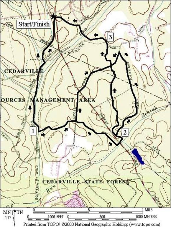
Blue Trail (3.95 or 3.3 or 4.2 miles, III)
This counter-clockwise loop starts easy by going south down
a stream valley. After crossing Sunset
Rd., several streams must be crossed without bridges and some of the trail may
be muddy. Quickly climbing out of the
stream valley, you reach the turn-off for the short route on
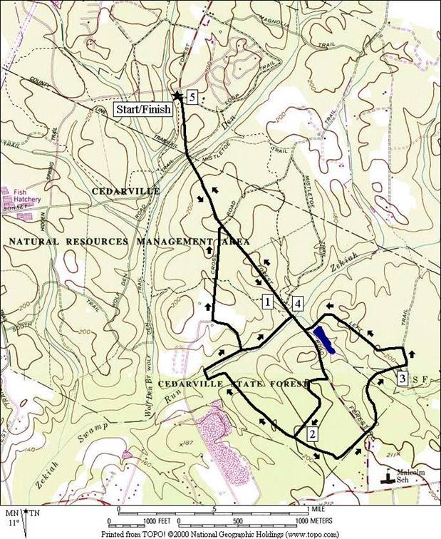
Forest Road (5, 4.1 or 4.25 miles, IV or III)
The
One option is to go left following the Brown Trail. It skirts the forest border, past some houses before dropping down to a wetland area. The wetland you see is actually only the head of a vast mile wide and many mile long wetland. Small wooden bridges get you across to make a counter-clockwise loop back to the parking lot and Forest Road.
The other option is to turn right at the T-intersection, following the Green Trail. The trail is nice at first however it deteriorates. First many tree roots make the going rough. It too drops down to the Zekiah Swamp. Once across a drainage ditch, the trail doubles back toward the Forest Rd. As of April 1999, your progress will be impeded when trying to stay on the Green trail (4.25 Mile Route). A somewhat wide and deep tributary creek blocks the way and there is no bridge. If you do hop across, the trail is poorly maintained but it can be followed to Forest Rd. by staying along the creek. Perhaps the scouts will fix this. Skip this mess by turning left up the steep hill to get on Cross Rd. and follow it to Forest Rd. (4.1 Mile Route). Return from there down and up Forest Rd. to the parking lot.
Food and Drink
Rips Casual Dining - Rte. 5 in Waldorf - breakfast, lunch and dinner with many seafood items
Spurs - country western dance club - 301 843-9964
Blue Dog Saloon - 301 932-1740
Roadside
barbeque (a seasonal specialty of southern Maryland)
Entertainment
and Edification
Cedarville Fish Hatchery
Wilmer’s Park - concerts - 301 888-1600
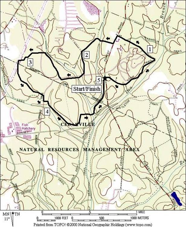
Distance: 5.0 miles
Rating: IV, single and double-track blazed trails rolling easily through the woods
0.0 into the woods; away from the road
R 0.05 Orange/Blue Trail (blazed)
0.3 cross
BL 0.4 on grassy double-track after the water tower on the L & trail X on R
0.5 Blue Trail goes R after wood bridge
1.05 double-track on L merges
1.1 double-track Rd X on L
1.25 gravel Rd X on L & gate; follow yellow blaze S
L 1.45 at T; Forest Rd; pass maint garage
R 1.5 orange blazed trail head near power poles
1.7 wooden bridge over stream
CR 2.2 to
trail head at
2.25 wooden bridge over creek
R 2.35 at trail X to stay on Orange Trail
2.45 cross
2.85 cross
BL 3.2 to join, then soon leave power lines (blazes and red flag)
BL 3.25 trail X (follow blazes)
BR 3.45 as trail X on L merges (follow blazes)
BL 3.55 as trail X on R merges (follow blazes)
R 3.7 Hidden Springs Rd
L 3.8 Orange Trail head (follow flag)
BL 3.85 at fork in trail (follow orange/red)
4.1 wooden bridge over stream
L 4.15 sharp L at T
4.7 wooden bridge over stream
BL 4.9 at trail X after wooden bridge over stream; Blue Trail is concurrent
R 4.95 to parking
5.0 parking
Orange Trail
|
|
Distance: 3.95 or 3.3 or 4.2 miles
Rating: III, mostly single-track blazed trails through rolling woods
0.0 into the woods; away from the road
L 0.05 Orange/Blue Trail (blazed)
L 0.1 to stay on Blue Trail as Orange Trail goes over wooden bridge
0.15 small wooden bridge
R/L 0.3 cross creek on Sunset Rd. (unmarked)
0.4 White Trail on R (closed) before steam crossing (no bridge)
0.65 steam crossing (no bridge)
0.75 steam crossing (no bridge)
L 1.0 after stream crossing to stay on Blue Trail; White Trail goes S
1.1 wooden bridge
<*
1.4 Cross Rd. (unmarked)
L 1.85 at T at creek; Green Trail joins
1.9 cross Forest Rd.; Green Trail goes R
<**
2.0 Mistletoe Rd. (unmarked)
2.1 wooden bridges over stream
2.3 small stream crossing
2.75 Cross Rd. (unmarked)
>*,>**
3.1 wooden bridge over stream
3.2 trail X before stream crossing
BR 3.25 at trail X after wooden bridge over creek
3.35 wooden bridge over stream
L 3.45 at trail X to wooden bridge; Blue & Orange Trail are concurrent
3.5 trail X on R to water tower
3.65 cross
L 3.9 trail X on L to parking
3.95 parking
on
![]()
3.3 Miles Route*
L 1.4 Cross Rd. (unmarked)
1.6 pass through gate
1.7 cross
L 2.1 Blue Trail (pickup cues at mile 3.1 on 3.95 mile route)
![]()
4.2 Miles Route**
R 2.0 Mistletoe Rd. (unmarked)
2.2 pass through gate after auto turnaround loop
L 2.85 Cross Rd. (unmarked)
R 2.1 Blue Trail (pickup cues at mile 3.1 on 3.95 mile route)
Blue Trail
|
|
Distance: 5.0, 4.1 or 4.25 miles
Rating: IV or III, mostly single-track blazed trails through rolling woods
R 0.0 onto
0.1 Sunset Rd. on R & bridge over creek
1.05 Mistletoe Rd. on L
1.1 Blue & Green Trail X
S 1.2 parking for pond on L; go uphill following Green and Brown Trail blazes
R 1.5 trail bears R at trail X on L
<*
L 1.95 at T; Brown Trail goes L; Green Trail goes R
2.4 gate to houses on R; Rd. X on L
2.8 wooden
bridges over
L 3.1 at T to follow Brown Trail
BL 3.2 at trail X; follow brown blaze
3.75 Cedarville Pond parking & pipe bridge
R 3.8 Forest Rd. (unmarked)
3.9 Blue & Green Trail X
>**
4.0 Mistletoe Rd. on R
>*
4.9 bridge over creek & Sunset Rd. on L
L 5.0 into parking
![]()
4.1 Miles Route*
R 1.95 at T; Brown Trail goes L; Green Trail goes R
2.55 trail goes L after crossing wet ditch
2.6 wooden bridge over creek
2.75 small wooden bridge
<**
L 2.8 trail X on L goes up hill leaving Green Trail before creek crossing
L 2.9 L at field & pavilion toward dirt road
R 3.1 Cross Rd. (gravel)
3.3 Blue Trail X
3.5 pass through gate
L 3.6 Forest Rd. (pickup cues at mile 4.9 on 5.0 mile route)
![]()
4.25 Miles Route**
S 2.8 at TR X on L; cross tributary creek without bridge; follow main creek on poorly maintained trail
3.1 Blue Trail merges from L
L 3.15 Forest Rd. (pickup cues at mile 4.0 on 5.0 mile route)
Forest Road
|
|