![]()
BL 0.85 trail X after tributary stream crossing
(no bridge); up hill
1.15 trail X on R
1.25 trail X on R
R 1.4 at T; trail over buried cable
1.65 trail X (pickup cues at mile 1.45 on 3.1 mile
route; end is 3.45 miles)
Most of the people driving today on
South and West of Clinton, Maryland in
The information above was derived from ASurratt House and Tavern...A Page in
American History,@ AThe Surratt Family & John Wilkes
BoothBCompiled
from the research of James O. Hall, @
and the Surratt Society.@ For more information on the Surratt House,
see visit the museum (see below) or go to WWW.SURRAT.ORG.
Getting There
From the Capital Beltway (I-495),
take
Area Routes
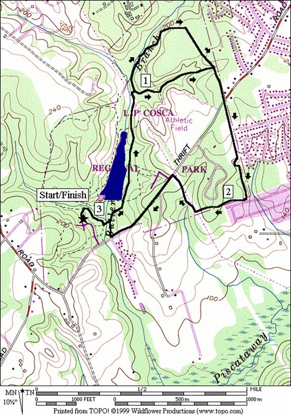
This lollipop route starts easy by
passing the lake on wide easy trails. As
you get past the lake, the route crosses under some high tension power
lines. You might, as did I, see a beaver
dam or a Great Blue Heron in the Butter Branch there. After the power lines and a small tributary
stream crossing, the shorter option goes right up a double-track road with good
footing along a stream. The longer route
continues north on single-track following the Butter Branch longer. At times the longer route gets perilously
close to washed-out stream banks. It is
hillier and with poor footing but both route options come together on a trail
atop an underground cable line. Some of
this trail is hilly. Cross Thrift Road
and continue along the buried cable line to a polygonal corner on the park=s border. Round the
campground and emerge along a dirt
roadway under the high tension power lines that takes you back to
L.F. Cosca
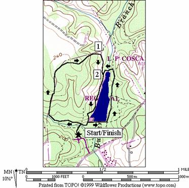
East and Lake Trails (2.55 or 1.7 miles, II)
Head down the unpaved trail only a
short way to a stream crossing. As you
come up after crossing it, you hit a six-way unmarked intersection. Bear left here on a green blazed trail, keeping
the stream on your left. The
single-track trail rises and falls along the stream before making a bigger
climb away from it along the east end of the park. This nice trail circles clockwise down to the
lake. Follow the shores to the dam and
loop fully around once, or turn from there to go directly back to the six way
intersection. The loop around the lake
is the flattest trail in the park and is only 0.85 miles long.
Nearby and Connecting Zones
Tucker Road
Community Park/Henson Trail
What to do Afterward
Food and Drink
Colony South Hotel - 301 856-4500
Olga=s Swiss & German Restaurant - 301 599-7629
Entertainment and Edification
Dr. Samuel A. Mudd House - at Poplar Hill Rd, Rte. 382
& Dr. Samuel A. Mudd Rd., Rte. 232 in Charles County; April-Nov. on
Wednesdays (11AM-3PM) and weekends (noon-4PM); 301 645‑6870.
Distance: 3.1
or 3.45 miles
Rating: III or IV;
mostly single-track trails through the woods and hills
0.0 from parking go down the steep unpaved trail
head (blazed red, yellow, blue & green)
R 0.05 yellow trail (blazed yellow)
L 0.15 blue trail (blazed blue); stairs down to wooden
bridge over creek
L 0.2 to stay on blue trail at park road
0.25 restroom on L
S 0.35 trail X on lake dam
0.5 pavement ends; S on gravel road
S 0.7 leave blue trail as it goes L to loop the
lake; also trail X on R
0.75 trail X on R
0.85 trail X on R under power lines
<*
BR 0.85 trail X after tributary stream crossing
(no bridge)
0.95 trail X
R 1.3 trail X (on top of buried cable)
>*
1.45 cross Thrift Rd (!)
1.95 trail turns R to leave buried cable
R 2.25 dirt road under power lines; uphill
CL 2.45 Thrift Rd (! use paved shoulder)
R 2.85 Group Pavilion entrance road into the park
L 2.9 blue blazed trail to wooden bridge over creek
R 2.95 yellow trail at top of stairs after crossing
creek
L 3.1 trail X; up steep hill to parking
![]()
BL 0.85 trail X after tributary stream crossing
(no bridge); up hill
1.15 trail X on R
1.25 trail X on R
R 1.4 at T; trail over buried cable
1.65 trail X (pickup cues at mile 1.45 on 3.1 mile
route; end is 3.45 miles)
Butter Branch
|
|
L.F. Cosca
East and Lake Trails
Distance: 2.55 or 1.7
miles
Rating: II or
I; out and back on a paved, wooded stream valley hiker-biker trail
0.0 from parking go down the steep unpaved trail
head (blazed red, yellow, blue & green)
0.05 yellow trail on R and red trail on L before the
creek
BL 0.1 on green trail at 6-way intersection after
crossing the creek; keep the creek on your left
BL 0.1 trail X on R
BR 0.6 at fields on L after trail on R merges (to
stay on green blazed trail)
BR 1.0 trail splits; BR for green blazed trail
R 1.15 at T at lake; trail around lake is blazed blue
1.3 trail X on R
1.35 trail X on R
1.45 cross spillway to dam
<*
L 1.5 trail X on L on dam; L to continue around the
lake
L 1.6 trail X after crossing dam; continue around
lake
1.8 pavement ends; continue on gravel road
1.9 gravel road ends; trail continues unpaved
L 1.95 trail X on L to go around lake (blue blaze)
2.0 trail X on R
2.15 trail X on R
2.2 trail X on R
2.3 cross spillway to dam
>*
S 2.35 trail X on L on dam; go S over grassy trail
then BR into woods on unpaved trail
BL 2.45 6-way trail intersection; BL to pipe bridge
over creek & up toward parking
2.5 yellow trail on L and red trail on R after
the creek
2.55 parking lot
|
|