![]()
Patuxent Research Refuge North Tract
During
the early 1990's as many military bases were closed around the country, a lot
of them were converted to park land and refuges. As Fort George G. Meade was reduced in size,
8,100 acres from it was added to the adjacent Patuxent Research Refuge and
became known as the refuge=s
north tract. Where tanks, military
transport vehicles and ordinance were tested, is now a land going wild
again. Already, there=s plenty of wildlife to be found. On one of my typical visits I=ve encountered one or more of the
following: deer, beaver, heron, egrets, black snakes or muskrats. The
Getting There
From
the Capital Beltway (I-495), take the
Area
Routes
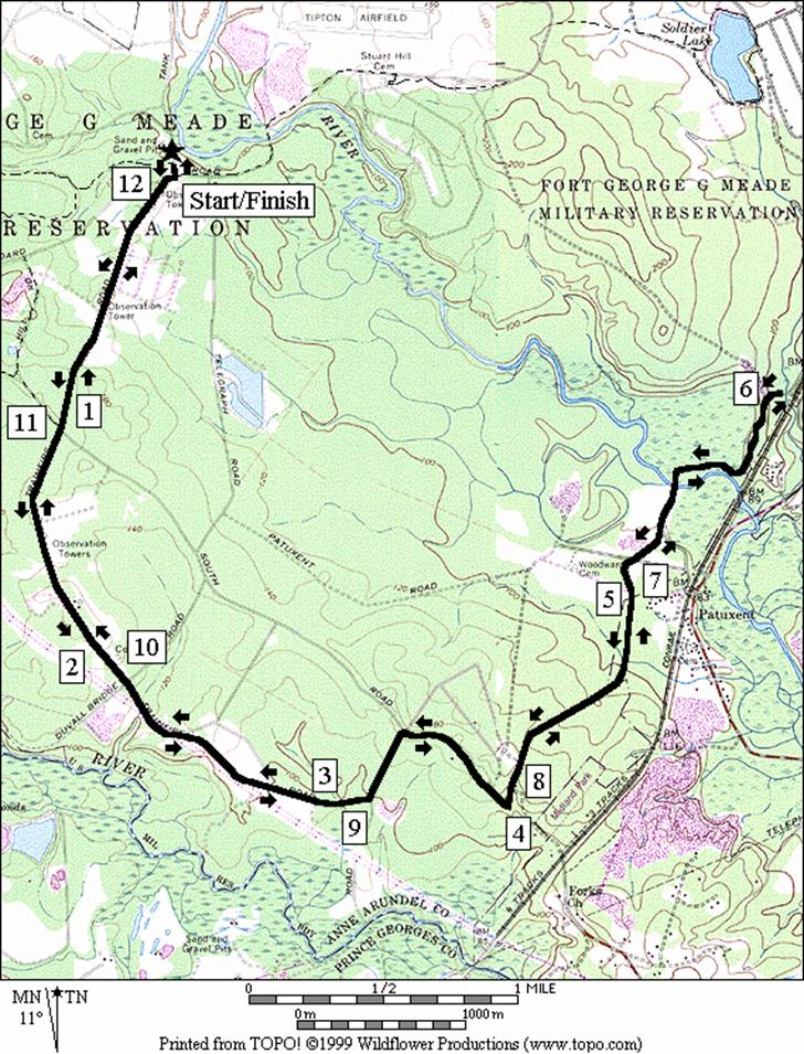
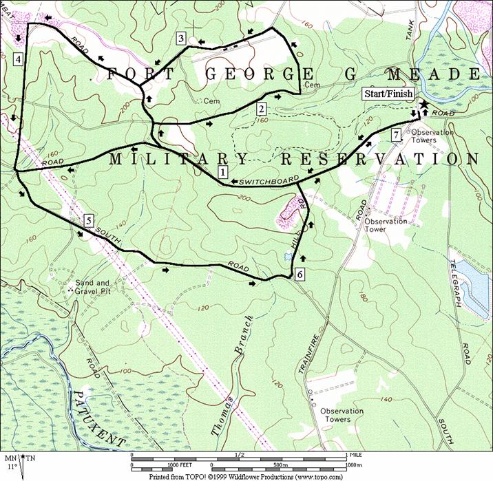
West Trails (7.1, 4.65 or 5.55 miles, VI, IV or V)
A rainbow of different Atrails@ are linked together west of the Visitor Contact Station B Green, Blue, Red, Yellow. They are marked with small narrow posts. The posts have different colored circles with arrows inside that point the direction. The Atrails@ are generally gravel and sand roads like that which is found on the C&O Towpath but often much wider. Grades are not steep and few last long. The Yellow Trail is my favorite of the lot but none of the trails are aesthetically exceptional compared to many other area parks. Trees line the trails most of the way. The principal attraction to them is the solitude and soft ground that can be conducive for good running or easy mountain biking. An old cemetery off the Yellow Trail, and Rieves Pond off the Green Trail are among the few focal points of interest. Watch for the sign posts carefully. The trail markings on posts don=t always stand-out against the backgrounds. There are usually gates to keep you from going on many intersecting roads that are off-limits however.
Previously
named
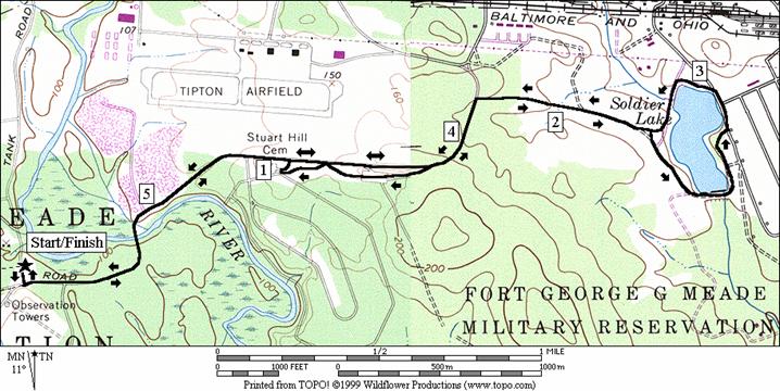
Wildlife
The Wildlife Loop is a paved road that serves as the principal auto route through the refuge. It is lightly traveled. Though it is called, and could be made into a loop, a necessary segment is kept closed. According to refuge volunteers, the closure is to discourage those who would race around the loop. Along the way to the closure gate, you can see open fields, marsh areas, and a small part of the Little Patuxent River. The crescent out and back route has a few hills and long grades. Some of the prettier parts are closer to the turn around area than to the beginning.
Nearby and Connecting Zones
Beltsville Agricultural Research Center
Fran Uhler Natural Area/Race Track Spur
Baltimore Washington International Airport, Thomas A. Dixon Jr. Aircraft Observation Area
What
to do Afterward
Food and Drink
Olive Garden - 301 498-0881
Old Country Buffet - 301 725-4713
Entertainment
and Edification
Patuxent
National Wildlife Refuge and
West Trails
Distance: 7.1, 4.65 or 5.55 miles
Rating: VI, IV or V, gently rolling gravel roads surrounded by trees
L 0.0 from the Visitor Contact Station
R 0.05 Wildlife
BR 0.05 Green Trail (sign to Rieve=s Pond)
S 0.65 Blue Trail is S; Green Trail turns L
<*
BR 1.3 Red Trail
<**
R 1.5 Yellow Trail
L 2.2 to stay on Yellow Trail at X; cemetery on R after turn
L 2.55 at T to stay on Yellow Trail
BR 3.25 Red Trail
>**
L 3.85 at gate to stay on Red Trail
4.35 power lines
L/R 4.5 at T to Blue Trail
>*
5.0 power lines
L 6.0 Green Trail to Rieve=s Pond
6.05 Rieve=s Pond
R 6.45 at T to stay on Green Trail
S 7.05 Wildlife Loop
L
7.1 Visitor Contact Station
![]()
S 1.3 Red Trail on R
L 2.05 at bottom of hill after power lines to stay on Blue Trail (pickup cues at mile 5.0 on 7.1 mile route; end is 4.65 miles)
![]()
S 1.5 Yellow Trail on R
S 1.65 to stay on Red Trail (pickup cues at mile 3.85 on 7.1 mile route; end is 5.55 miles)
West Trails
Lake
Distance: 5.65 or 5.75 miles
Rating: V, long easy grades on paved and gravel roads; sunny
L 0.0 from the Visitor Contact Station
L 0.05 Wildlife
0.45 begin Little Patuxent River bridge
1.05 Pine Trail on R (near cemetery)
1.2 Pine Trail on R
1.5 Pine Trail on R
R 1.75 gravel
road to
R 2.3 Jogging Trail on R
BL 2.55 toward dam
2.65 bridge over dam
L 2.65 at Rd X to follow around lake
L 2.95 at Rd X to follow around lake
3.2 pipe bridge (beaver dam on R)
3.3 Jogging Trail on L
L 3.9 Wildlife
<*
4.15 Pine Trail on L
4.45 Pine Trail on L
4.6 PineTrail on L
>*
5.15 begin Little Patuxent River bridge
R
5.65 Visitor Contact Station
![]()
L 4.15 Pine Trail on L
4.5 TR X on R to Wildlife Loop road (unmarked)
R 4.65 TR X on R at Ellicott=s Chapel site
L 4.7 L on Wildlife Loop road (unmarked) (pickup cues at mile 5.15 on 5.55 mile route
Wildlife
Distance: 12.1 miles
Rating: X, out and back on rolling paved roads; mostly sunny
L 0.0 from the Visitor Contact Station
R 0.05 Wildlife
0.05 Green Trail on R to Rieve=s Pond
0.55 Education Center on L (portable outhouse)
1.05 Green Trail on R to Rieve=s Pond
2.15
2.75 Scout Site 1
3.0 Scout Site 2
3.2 K Training Hunting (portable outhouse)
3.45
4.55 K Training Hunting
5.05 New Marsh on L
5.25 Cattail Pond on L
5.55 Bailey
Bridge Marsh on L (Little
U 6.05 at gate that closes road
6.55 Bailey
Bridge Marsh on R (Little
6.85 Cattail Pond on R
7.05 New Marsh on R
7.55 K Training Hunting
8.6
8.9 K Training Hunting (portable outhouse)
9.1 Scout Site 2
9.3 Scout Site 1
9.95
11.1 Green Trail on L to Rieve=s Pond
11.55
12.0 Green Trail on L to Rieve=s Pond
L 12.05 Bald Eagle Dr
12.1 Visitor Contact Station
Wildlife