Laurel River Walk
Laurel
has its early roots back into the 1600's and 1700's as a residence of the
Snowden family, then owners of much of what is now Montgomery
County. It wasn=t
however until the Laurel Factory came into being that the city took shape as a
small industrial town. The business
evolved from grist to cotton and saw milling.
By the mid 1800's, approximately 500 mill workers lived there along with
their families. In 1870, the town was
incorporated by Governor Oden Bowie and the city continued to grow. Being far from the county seat (at a time
when 30 miles was at least a day=s
trip), it did a lot on its own. The city
had its own water works and made it=s
own electricity long before other similar towns in the area. Railroads further connected and developed the
city. Today, some of the town=s history is preserved on it=s Main Street.
The
information above was derived from the A1870
- 1970 Centennial Historical Souvenir Booklet@
and the Laurel Historical Society web site.
For more information on the Surratt House, see visit the Laurel
museum (see below) or go to WWW.LaurelHistory.org.
Getting
There
From
the Capital Beltway (I-495), take I-95, north.
After 6.5 miles, exit onto Sandy Spring Rd.
(Rte. 198) headed east. After 1.8 miles,
turn left onto 7th Street.
Turn left again at Main
St. and park at the end of the road in the lot for
Riverfront Park.
Area
Routes
Laurel
River Walk (2.15
miles, I)
For
a city of Laurel=s size, it has relatively few
trails. The Laurel River Walk makes-up
for the lack of mileage by being charming (Note: Other nearby trails such as
the one along Brock Bridge Rd. in Anne Arundel County and the paths at
Laurel Lakes, do exist but they are not connected. Laurel
has many other undeveloped parks with potential too). Sitting below the ruins of an old dam, the
River Walk trail is in-between the town=s
Main St. and the Patuxent
River. The route follows the trail downstream, then
loops back through town back to the start.
Nearby
and Connecting Zones
Patuxent
Research Refuge North Tract
Beltsville Agricultural Research Center
Columbia - Village of Owen Brown
Food
and Drink
Red
Hot & Blue - 301 953-1943
Oliver=s - 301 490-9200
Ledo
Pizza - 301 498-5336
Entertainment
and Edification
Laurel
Museum - 301 725-7975
Montpelier
Mansion - Snowden family home circa
1871 - 301 953-7572; TTY (301) 779-5321
Laurel
Raceway (horse racing) - 301 725-0400
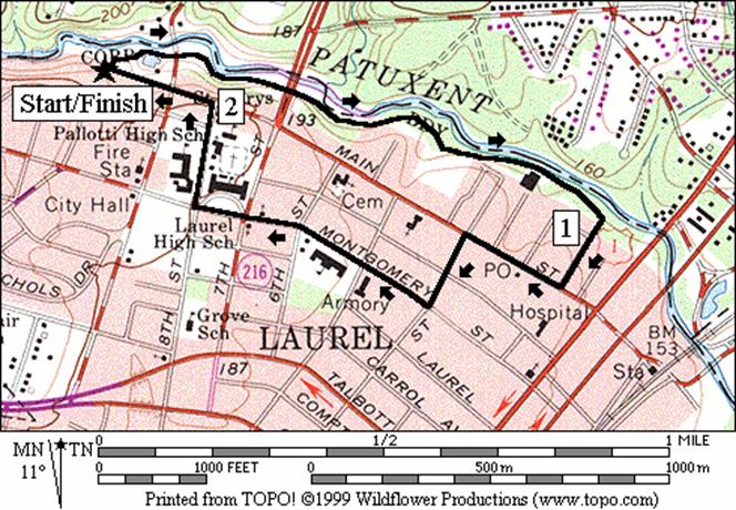
Laurel River Walk
Distance: 2.15 miles
Rating: I, mostly flat paved trails and
sidewalks
2.15
Mile Route
R 0.0 from
onto the trail head at the parking lot
0.1 9th St
and TR X on R
0.3 underpass
7th St
0.8 parking
on R and portable outhouse
R 0.9 TR
X on R to wooden bridge
S 0.95 B
St (unmarked)
CR 1.1 Main St
CL 1.25 Fourth St
R 1.4 Montgomery St
R 1.80 St
Mary=s Pl
L 2.0 Main St
2.15 trail
head in parking lot