![]()
*
From
the
Following
some of the trails in the area can be dauntingBeven
for those living in
Getting There
From
the Capital Beltway (I-95), take I-95 north toward
Area
Routes
Poised
off the
The
loop around the lake is 1.85 miles, just the same distance as that around
This
route crosses north of the Little Patuxent Pkwy. (Rte. 175) and rambles through
the
Nearby and Connecting Zones
What
to do Afterward
Food and Drink
Bob Evan=s -
Bertucci's Brick Oven Pizzeria - 410 312‑4800
Romano's Macaroni Grill - 410 872‑0626
Entertainment
and Edification
Merriweather Post Pavilion - 301 982-1800
410 730-7105
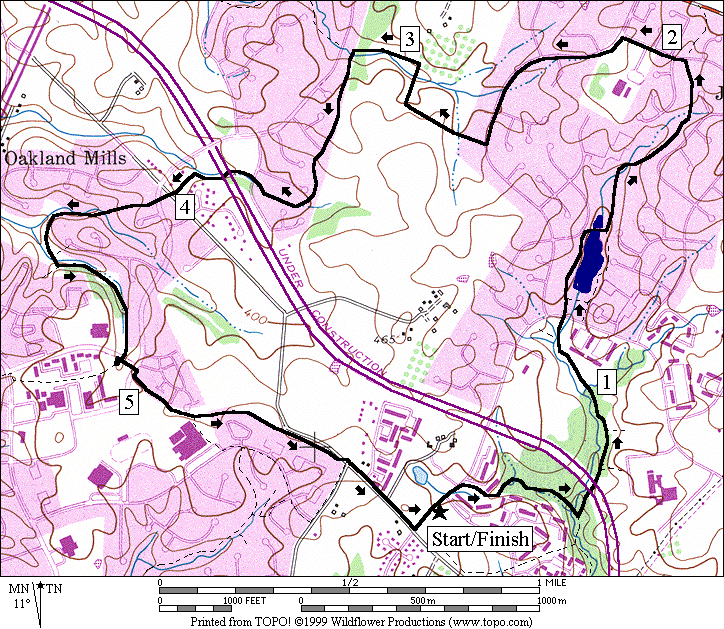
Distance: 5.15 or 7.4 miles
Rating: IV or VI; mostly paved trails over rolling hills
L
R
XS 0.3 Oakland Mills Rd; follow the paved trail
0.75 trail X on L to high school
R/L 0.95 R on
L/R 1.0 trail X on L after trail overpass; Talbot
Springs trail system (unmarked)
R/L 1.3 to cross
1.65 begin bridge over Rte 29
<*
R 1.85 at the lake; trail X on R to bridge over
creek
BL 2.15 trail splits at
S 2.2 onto unpaved trail
2.55 cross stream at north end of lake
R 2.65 grassy trail; becomes wood chip/gravel
L 2.7 at T on paved trail
>*
L 2.95 trail splits; stay near shore at town center;
follow the docks around the boat area
3.25 trail X on R; boat ramp on L
3.3 trail X on L for lake
loop at lake=s south end
3.5 end of bridge over Rte 29
R/L 3.8 to cross
L/R 4.1 trail X on L to
R/L 4.2 R on Thunderhill
Rd/L on trail head to
4.4 trail X on R to high school
XS
L
R 5.15 Jeffers Hill Elementary
![]()
*
1.85 trail X on R to bridge over creek
L 1.9 trail X on L; boat ramp on R
R 2.0 Little Patuxent Pkwy
2.25 pedestrian overpass
for mall
2.85 trail X on R merges
from the lake
L 2.9 Vantage Point Rd; becomes
L 3.0 Hyla Brook Rd
(also trail X on L for return)
L/R 3.15 L into parking and R onto dock/trail
L 3.55 trail X at map & lake after bridge over
creek
L 3.6 at trail X to stay on the lake loop
3.65 Rivulet Row
L 3.75 L Waterfowl
Terr
L 3.85 trail X on L before Green Mtn
Cir
L 3.9 at T; follow shoreline over the wood chip
trail & through the trellis
4.3 dam on L; steep
winding hill ahead (!)
S 4.35 trail X triangle on L for
R 4.45 onto
CR 4.55 Little Patuxent Pkwy
BL 4.6 trail X on L (unmarked) to lake
4.85 trail X triangle on
L
4.95 wood chip/gravel trail on L from lake loop
(pickup cues at mile 2.95 on 5.15 mile route)
Lake
Lake
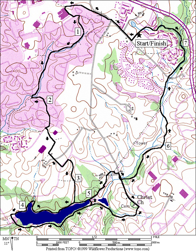
Distance: 7.6 or 5.95 or 7.95 miles
Rating: VI, V, or VII; paved trails, a short dirt and gravel road, mostly well graded hills
L 0.0 on
R
XS 0.3 Oakland Mills Rd; follow the paved trail
L 0.75 trail X on L to high school; pass basketball
and tennis courts to the road
L/R 0.9 CL on
BR 1.5 at trail X on L to the follow creek
BL 1.55 at trail X to follow the creek (2nd
map)
L 1.95 at T after creek (power lines); begin uphill
2.0 Windharp Way
(unmarked)
R 2.2 trail X triangle at
CL 2.25 at Younghart La
toward Owen Brown CC
2.4 trail X on L as trail bends sharp to R in
field
L 2.55 at trail X; school is on the R
CL
R 2.8 trail X on R (unmarked); downhill to lake
L 2.9 at trail X (downhill); R is to Smooth Path
BR 3.05 after wood bridge at trail X to continue
going downhill; L is to Wrestling Sun
3.1 trail X on R to Smooth Path
<*
R 3.25 at T;
4.1 trail X on R to tunnel under
4.25 trail X on L to dam; restroom/water
<**
BL 4.9 trail X triangle; R to Brush Run
R 5.0 at T after bridge; leave the lake
>*
BR 5.15 on grass/dirt road that follows the power
lines as the paved trail bears L to the houses
CR 5.3 trail along
R
BR 5.45 trail head on R before creek
>**
BL 6.2 toward creek; trail X on R
6.5 Tamar Dr at dead end (unmarked)
BL 7.1 at trail X on R toward tunnel
L 7.4 at trail X toward road after bridge
L
7.6 Jeffers Hill Elementary
![]()
*
L 3.25 at T;
![]()
**
BR 4.9 trail X triangle; R to Brush Run
5.0 trail X, triangle merges under power lines
5.1 trail X on R to Rustling Leaf
5.15 trail X on L to Farbell
Row
BL 5.2 trail splits (unmarked)
BL 5.3 trail X on R to
L
UL 5.8 trail X on L after creek (sharp turn)
(pickup cues at mile 6.2 on 7.6 mile route)
Lake
|
|
Village of
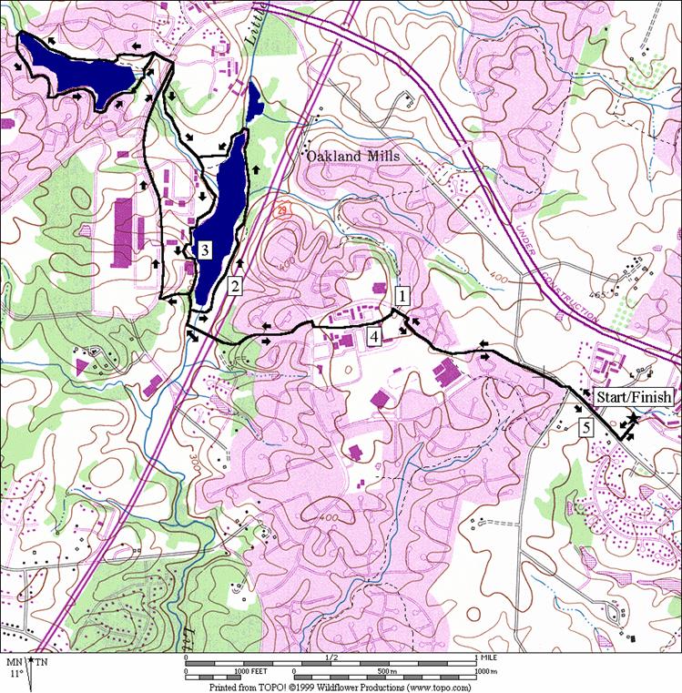
Distance: 5.9 miles
Rating: V; rolling paved trails and sidewalks
R
R 0.1 trail
head on R after
R 0.15 trail X on R to wood bridge to follow creek (many bridges ahead)
L 0.5 toward tunnel at trail X
0.55 tunnel under Rte 175
L 0.7 trail X triangle
R 1.05 trail X triangle before road
1.1 underpass
1.15 trail X on R (pond loop)
L 1.4 at T after wooden bridge over pond
1.5 trail X triangle; trail X on R
1.7 trail X
L 1.95 High Tor Hill (unmarked road)
L 2.15 Phelps Luck Rd (store)
CR 2.6 Billow Row
CR 2.85 Summer Hollow La
L 2.95 Broken
L 3.05 trail head on L (Talbot Springs trail system, unmarked)
L 3.15 at trail X to go over bridge & up hill
3.45
R 3.6 trail X on R to wooden bridge to stay on main trail
3.75 Sleeping Dog La (unmarked)
3.8 tunnel under Rte 175
4.05 tunnel
under
R 4.2 trail X on R to stay on main trail
4.35 trail X on R (map)
L 4.5 trail X triangle after wooden bridge to follow main trail uphill
R 4.9 trail
X on R to
R/L 5.0 CR
Thunder Hill Rd; L on trail head to
5.15 trail X on R to high school
XS
L
R 5.9 Jeffers Hill Elementary
Village
of