Beltsville Agricultural Research Center
The
Beltsville Agricultural Research Center (B.A.R.C) is a facility of the Department
of Agriculture. It stretches from College
Park to Bowie
and from Greenbelt to Laurel. Primarily farmland, it is the largest patch
of open space close-in to Washington, D.C.
and makes-up part of the green-space surrounding Greenbelt. Since it’s a place of business, not a park,
much of the B.A.R.C. facility is off-limits to the public. The parts that are open however, provide a
pleasant place to workout for runners, cyclists, and in-line skaters. Herds of deer 30 and 40 in number, crowded in
from the encroaching suburban development, can sometimes be seen roaming along
the edges of the fields near sunrise and sunset.
Getting
There
From
the Capital Beltway (I-95), take the Baltimore
Washington Pkwy. north 3.65 miles to Powder
Mill Rd.
Turn right on Powder Mill Rd.
following signs toward the N.A.S.A Goddard Space
Flight Visitor Center. Turn right one quarter mile later onto Soil
Conservation Service Rd. Turn left after one mile onto Beaverdam
Rd. Turn
right immediately into the small and unostentatious Crider
Memorial Garden
parking lot.
Area
Routes
Beaverdam Road
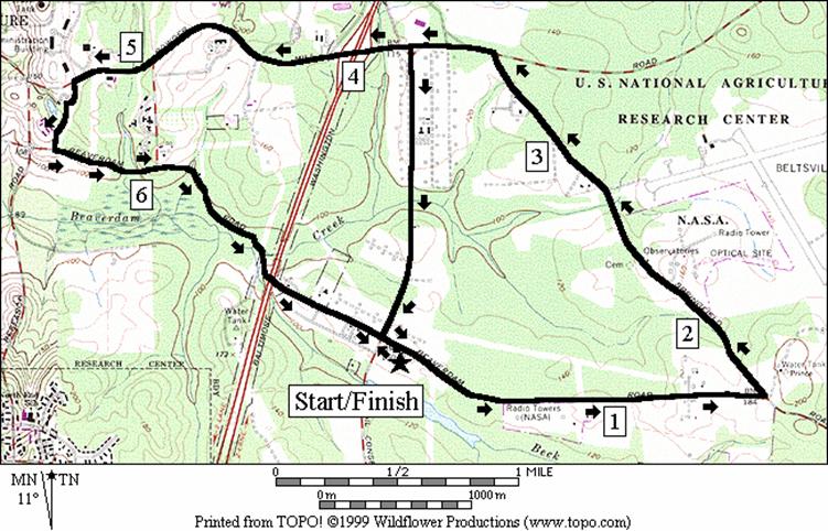
East (7.3 or 5.1 miles, VI or IV)
The
open surroundings for most of this route make it best used on days when
temperatures are comfortable or even cool.
Spring can offer-up the bright green colors of new crops in the fields
and breezes to push or slow you. On a day after a rare Washington,
D.C. snowfall, the roads are generally
cleared enough to be passable on foot, thus offering an alternative to going in
circles in a smaller park somewhere else.
Winter is also the time of year for one of Washington,
D.C.’s oldest but lesser known running
marathons. In fact, this course, though
it starts from a different place, follows nearly the whole route used by the George
Washington’s Birthday Marathon which is held annually in February. That marathon travels this loop three times
with additional mileage run on Springfield Rd. By marathons standards, the topography of the
course is considered hilly but for traveling a single loop, the hills do not
factor heavily into finishing. You’ll
probably focus more on the tranquil countryside. On one end of the route, you will pass the National
Agricultural Research
Service Visitor Center,
a lodge built by the Civilian Conservation Corps. Many cyclists use the roads of this route as
well as other B.A.R.C. roads. Relatively
few cars pass through except during rush hours.
Even then it usually is tolerable.
No water is available. The long
route can be cut short by skipping the trip to the lodge and returning on the
slightly busy Soil Conservation Service Rd.
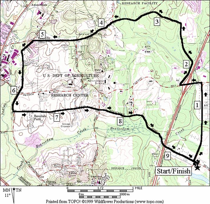
Odell Road (9.5 miles, VII)
A
little more shady than the Beaverdam Road East
routes, this route is also longer and just a little hillier. Good paved shoulders along Soil Conservation
Service (SCS), Powder Mill, Odell, and Edmonston roads were designed with
bicycle traffic in-mind and make sharing the road with auto traffic
manageable. Some caution is necessary
however first along SCS where traffic is sometimes fast, and next along Springfield Rd.
where for one mile there is no shoulder and more than one blind curve. The route tours to the northern borders of
the B.A.R.C where occasional houses and subdivisions have recently been built. The site of the Van Horn’s Tavern (no longer
standing), is also on the route and once was a well traveled stopping point for
George Washington and others during colonial times. Rochambeau’s troops camped there in 1782 upon
returning from victory at Yorktown. No public access water or facilities are
available on route.
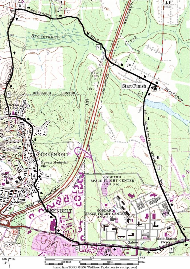
N.A.S.A (7.9 miles, VII)
Use
this route to do some hill training.
After a short downhill start, a three-staged increasingly steeper mile
long climb puts you near some of the buildings of the N.A.S.A
Goddard Space Flight
Center. Look back from where you came and you’ll see
all the way to Anne Arundel and Montgomery counties. It’ll probably feel like more, but the hill
is not as high as it seems with only a 120ft of vertical elevation gain. The early portions of the route pass along
some busier roads but the view, and the segments in Old Greenbelt, Research
Rd. and Beaverdam Rd.
make it worthwhile. See the routes in
Buddy Attic Park/Old Greenbelt for descriptions of the Greenbelt
and Research Rd. segments. The final section returns over rolling hills
on Beaver Dam Rd.
Nearby
and Connecting Zones
Buddy Attic Park/Old Greenbelt
Patuxent Research Refuge North Tract
Laurel River Walk Trail
Fran Uhler Natural Area/Race Track Spur
What
to do Afterward
Food
and Drink
La
Hacienda - Mexican - 301 262-8800
Maharaja
- Indian cuisine - 301 552-1600
Osaka
- Japanese - 301 552-1442
Gringada
- Mexican cuisine Rt 1, Beltsville - 301 210-3010
Entertainment
and Edification
National
Aeronautical Space Administration (N.A.S.A.) Goddard Space Flight Visitor
Center - 9AM - 4PM daily - 301
286-2000
Patuxent
National Wildlife Refuge and Visitor Center
- short hikes, waterfowl, indoor nature exhibits, tram tour (301) 497-5760
Howard
B. Owens Science
Center - planetarium - 9601
Greenbelt Rd - 301 918-8750
Dorsey
Chapel - rural African American community church from circa 1900 - 301
352-5544, TTY 301 669-2544
Marietta
- plantation home of Gabriel Duval, Associate Justice on the Supreme Court in
1811; 301 464-5291, TTY 301 277-8456
Montpelier
Mansion & Arts Center
- 1783 mansion; artists and classes; mansion 301 953-1376, TTY 301 699-2544; Arts
Center 301 953-1993, TTY 301
490-2329
7.3
Mile Route
R 0.0 Beaverdam Rd
from parking lot
1.05 gate
to cornfield; bottom of hill on R
L 1.6 Springfield Rd
2.2 Goddard
Geophysics & Astronomical Observatory on R
L 3.4 Powder
Mill Rd (use shoulder)
<*
3.8 Soil Conservation Rd
4.0 B. W. Parkway
underpass (!)
4.1 Springfield Rd
4.9 Pesticide Rd
5.0 Entomology Rd
L 5.3 to
National Visitor
Center
BL 5.4 through
parking just past visitor center
L 5.6 Beaverdam Rd
5.95 one
lane bridge (!) (on downhill)
6.05 Pesticide Rd
6.6 one
lane bridge
6.8 B. W. Pkwy
underpass
7.0 8712
Beaverdam Rd
7.3 Soil Conservation Rd
>*
R 7.35 into
parking

*5.1
Mile Route
CL 3.8 Soil Conservation Rd
L 1.05 Beaverdam
Rd (pick-up cues at mile 7.35 on 7.35 Mile route)
Beaverdam Road East
Odell
Road
Distance: 9.5 miles
Rating: VII; paved roads through woods, farm
fields
L 0.0 Beaverdam Rd; from
parking
R 0.05 Soil Conservation Rd
(use shoulder)
L 1.3 Powder Mill Rd at
T
1.5 B.W. Parkway
underpass (!)
R 1.6 Springfield
Rd. (! first mile w/o shoulder or path)
2.65 Capitol
College
2.8 Lighthouse Pl
BL 3.15 Odell Rd
BL 3.95 at
stop, to stay on Odell Rd
at Elington Dr
4.0 Odell
Farm Ct
4.7 Poultry Rd
5.0 5414
Odell Rd
BL 5.1 Old
Baltimore Pike (site of Van Horn’s Tavern)
CL 5.35 Edmonston
Rd. (! use shoulder)
6.0 Powder
Mill Rd (!)
L 6.3 Beaverdam Rd
6.85 one
lane bridge
7.65 Research Rd.
8.05 one
lane bridge (!) (on downhill)
8.2 Pesticide Rd
8.75 one
lane bridge
8.9 B. W. Pkwy
underpass
9.45 Soil Conservation Rd
R 9.5 parking
N.A.S.A
Distance: 7.9 miles
Rating: VI; paved roads, sidewalks
L 0.0 Beaverdam Rd;
from parking
L 0.05Soil Conservation Service (SCS)
Rd.
1.35 traffic
signal
1.6 N.A.S.A
Goddard Visitor Center
entrance
CR 1.85 Greenbelt
Rd 193 (!); (use sidewalk &
shoulder)
2.4 N.A.S.A
Goddard main entrance & shopping center
2.5 Cipriano Rd
XS 3.05 at Mandan
Rd Xwalk
R 3.3 E.
Roosevelt HS exit at Frankfort Dr;
use sidewalk
BR 3.4 counter-clockwise
around HS, through parking lot toward apex of Hanover Pkwy & Xwalk
BR 3.6 cross
Hanover Rd; start Gladys Noon
Spellman Trail (unmarked Xwalk & sidewalk to paved path)
3.7 hiker/biker
bridge over B.W. Pkwy
R 3.9 Ridge
Rd. (use sidewalk)
4.05 Hamilton Pl
4.4 Northway
4.55 Plateau Pl
4.75 Laurel Rd
R 4.85 Research Rd
5.1 BARC
gate (pass under if closed)
5.75 Beaverdam
Creek bridge
R 6.05 Beaverdam
Rd (just past gate; pass under if closed)
6.45 one
lane bridge (!) (on downhill)
6.6 Pesticide Rd
7.2 one
lane bridge
7.45 B. W. Pkwy
underpass
7.85 Soil Conservation Rd
R 7.9 to
finish & parking