|
|
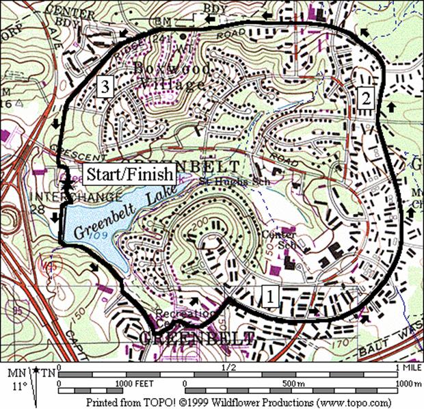
Buddy Attic Park/Old
Getting There
From
the Capital Beltway (I-95), take
Area
Routes
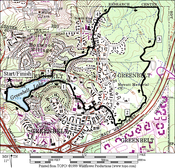
Greenbelt Woods (5.4 miles, IV)
Tour
the green belt of
Circling
the original town, this route also starts along the lake but is on sidewalks
most of the rest of the way. After
climbing a short hill to the rim of the natural bowl shaped topography that the
town sits on, you’ll first pass the small cooperative duplex houses with small
yards and nice gardens. Gradually
climbing higher, pass some of the Greenbelt Woods. Near the highpoint, just before the water
tower, you’ll have a view of the cow pastures below in the Beltsville
Agricultural Research Center (BARC) below.
A descent along the gravel portion of
Rural-like
farm roads through corn fields make-up the bulk of this route. In the BARC, it’s hard to believe that you’re
only a little over a mile away from the busy Capital Beltway and not in the
Nearby
and Connecting Zones
Beltsville Agricultural Research Center
What
to do Afterward
Food
and Drink
Generous
Joe’s Deli - Subs and Pizza; Centerway in the
New Deal Café - 301 474-5642
Entertainment
and Edification
Patuxent National Wildlife Refuge - short hikes, waterfowl, indoor nature exhibits, tram ride 301 497-5760
P & G Old Greenbelt Theater - large screen movies - 301 474-9744
Ultimate
games - pick-up flying disc games in the Northway Fields (summer Sundays at
S 0.0 from parking; down toward lake (unpaved)
R 0.0
BL 0.2 at T after bridge at dam
L 0.4 trail X (unmarked; continue around lake)
S 0.9 bridge on L; leave the lake (unmarked)
1.0 bridge over stream
R 1.0 at T; Greenbelt Trail (unmarked, paved
ashpalt); pass volleyball & tennis cts.
BL 1.1 toward
BR 1.3 counter-clockwise around parking lot
L 1.3 Centerway on sidewalk before Crescent Ln.;
pass town center (food/drink)
R 1.4 Xwalk to tunnel, under Crescent Ln
L 1.4 on sidewalk at T after tunnel
R 1.5 Gardenway; becomes 28 Ct Ridge Rd.
S 1.7 Gladys Noon Spellman Trail (paved asphalt,
unmarked) toward E. Roosevelt H.S.
L 1.8 trail head into Greenbelt Woods (unpaved)
opposite dedication plaque on R. See the
No Bicycling sign. The trail parallels
the
2.0 gully
2.1 top of cemetery hill (
BR 2.3 trail X;
R 2.5 trail X/diving board bridge over gully
S 2.6 exit woods, through gravel parking area
L 2.7 Northway Rd. (unmarked/unpaved)
R 2.7 trail head (unmarked;@ look for dirt mound
and no cycling sign)
2.8 wooden bridge
BR 2.9 trail X (unmarked, go uphill)
3.0 trail X (unmarked trail is on left)
3.4 trail X (unmarked, stay along fence)
S 3.6 trail X @ deep gully (unmarked, cross gully
and continue along fence)
3.7 trail X (unmarked faint trail is sharp to
left, stay along fence)
L 3.8 4 way unmarked trail X; take 2nd
wider trail on L; leave the fence
BR 3.9 at trail split along drainage (unmarked)
S 4.0 leave woods onto
R
R 4.3 ramp to
R 4.4 Northway Stream Valley Park hiker/biker
trail through tunnel under
R 4.7 Crescent Ln trail (unmarked/paved asphalt)
L 4.8 Cross Crescent Rd at
R 4.9 Lake Trail (unmarked cinder trail)
R 5.3 Uphill to parking lot. (water before turn)
5.4 Finish at
Distance: 3.4 miles
Rating: II; in-town paved foot trails, moderate hills, view of BARC
S 0.0 from parking; downhill towards lake (unpaved)
R 0.0
BL 0.2 at T after bridge at dam
BR 0.4 trail X (unmarked; leave lake)
CL
R 0.7 Westway
R
1.0 at
1.1 Southway (!)
1.4 28
Ct
1.9 Northway
2.0 51 Ct Ridge Rd.
BR 2.6 Ridge
Rd (don’t cross
3.0 pavement begins
S 3.3 X Crescent Rd (!) at T onto asphalt foot trail
L 3.3 access
road to
3.4 Finish
at
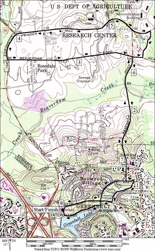
S 0.0 from parking; downhill towards lake (unpaved)
L 0.05
L 0.4 at T (leave lake)
CR 0.5 Crescent Rd on paved foot trail
L 0.6
L 0.95 ramp
to
BR 1.0 Hillside Rd (unmarked)
R
1.4 BARC gate (pass under if closed)
2.05 Beaverdam Creek bridge
L 2.3 Beaverdam Rd (just past gate; pass under if closed)
3.15 one lane bridge
R 3.65 Edmonston Rd (!) (use shoulder or grass)
R 4.0 Powder Mill Rd. (!) (use shoulder)
4.05 Guard Office & map; Bldg 156
R 5.4 to
BL 5.5 through parking area; downhill just after the visitor center
R 5.75 Beaverdam Rd (unmarked)
L 5.85 Research Rd (pass under gate if closed)
6.0 woods at edge of fields
6.15 Beaverdam Creek bridge
6.8 BARC gate (pass under if gate closed)
R
R 7.55 Crescent Rd (on asphalt path)
7.7 Eleanor Roosevelt memorial tree
S 7.9 Lastner La (begin shoulder on Crescent Rd
L 7.95 into
8.0 Finish
at