Baltimore Washington International Airport Trail
Thomas A. Dixon Jr. Aircraft Observation Area
The
trail around the Baltimore Washington International Airport (BWI) was completed
in 1999 and put together around the same time that the roads in the area were
widened. The trail makes a good long loop for runners looking for long sunny
wintertime runs, or for cyclists looking for a short loop with little
traffic. In-line skaters will require
skills well beyond the beginner level to complete the loop but might enjoy shorter
out and back ventures. Much of the trail
lies in-between the airport and the highways that surround it. Fortunately, unlike other trails built
alongside transportation projects elsewhere, the trail is usually not too close
to the road. Occasional patches of trees
give shelter from winds and noise, and offer some more natural scenery. Of course, good views of the planes at Thomas
A. Dixon Jr. Aircraft Observation Area can be seen too. The BWI Trail connects to the
Getting There
From
the Capital Beltway (I-95), take the
Area
Routes
Baltimore Washington International Airport Trail (10.55 miles, IX)
This
paved trail literally circles around the airport. It offers a change from the more common
stream valley or railroad grade trails found elsewhere. Much of the loop is in the open therefore, it=s probably not one to choose for a hot
or very windy day. There are very few
places to get water or use restrooms along the way. Most of the loop is fairly flat but there are
a few long gradual grades on the northern sides. One of these leads up to a commanding view of
the airport runways. You can see much
more at this view than the view at Gravelly Point, nearer
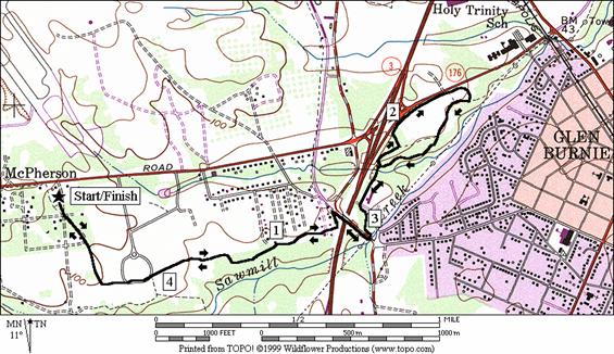
Sawmill Creek (4.6 miles, III)
From
the observation area, the way to
Nearby
and Connecting Zones
What
to do Afterward
Food
and Drink
Denny=s - off
Bagel
Club -
Entertainment
and Edification
Ben Hammond House - 410-768-9518
National
Aquarium In
Baltimore Washington International Airport Trail
Distance: 10.55 miles
Rating: IX; rolling to flat paved trails; open sunny areas
R 0.0 on the spur trail from the observation parking lot; the loop route goes clockwise
R 0.05 BWI Trail
XS
2.3 begin long wooden bridge
2.95 trail goes R at the
CL 3.15 Stoney Run Rd to cross over Rte 170,
R 3.3 onto trail ramp just after crossing the bridge
4.0 trail joins
R 4.2 cross
4.6 begin bridge over I-195
L 4.9 trail
X on L (sign to
CR 5.25 Elkridge
Landing Rd at
5.5 trail bears L away from the road to
5.85 overlook of airport on the hilltop
6.15 restroom
in
R 6.3 at
T to stay on trail; use street sidewalk for
6.6
CL 7.15 Aviation Rd (unmarked) to stay on the trail
CR 9.25 Newport
Rd; sign to BWI Overlook to stay on BWI Trail; S is to B&A Trail and
10.0 unpaved road on L
R 10.5 spurt to parking
10.55 observation parking
Baltimore Washington International Airport Trail
Sawmill Creek
Distance: 4.6 miles
Rating: III; paved trails
L 0.0 from observation parking
0.05 loop trail merges on R
0.5 old unpaved road on R
R 1.3 Hammonds
Ferry Rd to cross over I‑97 on bridge; becomes
L 1.5 at Old Stage Rd; onto the paved trail
1.55 bridge and court
1.8 wooden bridge over Sawmill Creek
L 1.9 sharp
L onto trail that merges on L (unmarked);
L 1.95 at T at ballfields to stay on loop
2.2 Charlie
Eckman La (
2.25 trail X on R between tennis courts
R 2.3 trail X on R after tennis courts
R 2.35 at T onto the BWI and B&A connector trail
BL 2.5 after ballfields at trail X
BL 2.7 complete
loop where trail splits; R is
2.8 wooden bridge over Sawmill Creek
3.05 bridge and court
CR
L 3.3 BWI
Trail along
4.05 unpaved road on L
R 4.55 to parking
4.6 observation parking
|
|