Leesburg
Leesburg embodies the historic nature of Loudoun
County better than does
Ashburn. As of 1999, it is on the
boundary line of suburbia and the country.
It’s not only the
largest town in Loudoun County,
it is also the largest town in Virginia.
Numerous in-town loops can be run,
taking advantage of sidewalks and quiet residential streets. In addition, the
W&OD trail runs through the town and there are plans for additional
trails. There is also a historic
district that is nice to run through.
Leesburg is the hometown of Westmorland Davis, the Governor of Virginia
from 1918 to 1922. The estate is now Morven
Park; open April through
October. There’s no shortage of out-of-town loops for running either. Most involve both distance and hills but are
great for marathon training. The bucolic
nature of the area is intact as of 1999.
Numerous dirt roads are around still which make for good mountain bike
loops as well as running loops. Most of
the routes in this section were adapted from routes contributed by Ralph Keith,
formerly of the Loudoun Road Runners.
Leesburg has several nice restaurants and shopping. Market Station within sight of the W&OD
Trail in Leesburg, has several nice restaurants for after the run. How about doing a late Sunday run in July or
August that finishes at 7:00PM at the
courthouse, just in time for the start of the Bluemont Summer Concert on the
courthouse lawn? Leesburg also has an
outlet mall, including a Nike and a Reebok outlet store.
Getting There
From the Capital Beltway
Take Exit 12, for the Washington Dulles Access and Toll
Road, Rte. 267, west. When getting on to the expressway, stay to
the outer (right) lanes. The inner
(left) lanes are only for access to Washington
Dulles International
Airport. After 12 miles, just past Sully
Rd., Rte. 28, a second toll must be paid to
continue on Rte. 267; from here called the Dulles Greenway. Follow the Dulles Greenway approximately 12
miles further, to Leesburg. Head West on
the Rte. 7 bypass toward Winchester. Take the Rte. 7 Business Exit into
Leesburg. Take a right at the first stop
light onto Fairview Street
which becomes Catoctin Circle. Cross the W&OD Trail, then turn right
into the Loudoun County
High School parking lot. Start at the fire hydrant.
Area Routes
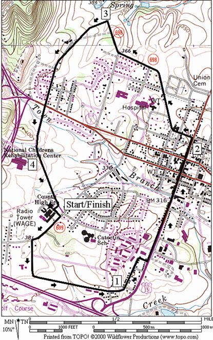
Leesburg In Town (4.25 miles, III)
When the Loudoun Road Runners aren’t pounding the hills,
they are leisurely looping through the town of Leesburg. This route combines some of their most often
used segments also making a sort of historic tour. First go through the quiet streets near the high
school. Run right through town on King
Street. As
you cross the W&OD Trail, the brick street sidewalks may be a bit
congested. After crossing Market
Street however, it’s quickly over. Take Old Waterford
Road out past the Rust Library and Ida Lee Park,
then return on Fairview’s sidewalks
and shoulders.
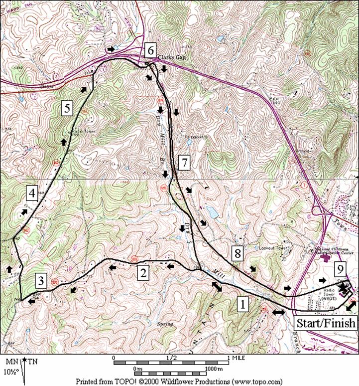
Thomas
Mill Road (9.15 or 9.35 miles, X)
There’s
nothing like a good mountain run and the feeling of accomplishment you get from
having done it. The hill going up Thomas
Mill Rd. is one of the toughest in this guide.
Short segments are steep. It
climbs in 5 stages 400 vertical feet from the base over a distance of 1.6 miles
to a top; elevation of approximately 790 feet.
At the top are some spectacular views Visible are Reston, Tysons Corner and if you
look carefully, Northwest Washington D.C. which is 34 miles away as the crow
flies. Leaving the parking lot to get
started take a right on Dry Mill Rd. Proceed on Dry Mill Rd. past the overpass for
the Rte. 7 bypass and to the intersection with Thomas Mill Road (State Rt.
820). Take a Left on Thomas Mill Road
and run up the hill. Take a right on
Canby Road going down and bear right at the intersection with Diggs Valley Road
(State Rt. 707) to continue on Canby Road.
Canby Road is gravel and there are several parts under the woods. The climbing’s not over after the first hill. A second climb of 100 vertical feet in 0.6
miles takes you near a radio tower. Take
a right after it onto Colonial Hwy., Rte. 7 business, at the stop sign and
proceed just past the intersection with Charles Town Pike, Rte. 9. This less than half mile segment on Rte. 7 is
where you need to be careful due to a narrow shoulder and a 55 mph speed limit. At Charles Town Pike pickup the W&OD
Trail and descend the next 3.2 miles all the way into Leesburg. As an option, use Dry Mill Rd. to
return. Psyche yourself up. Work up to
it. Go do it.
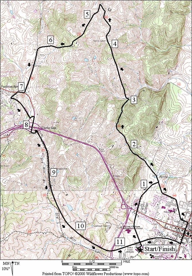
Old Waterford Road (11.35 or 12.25 miles, X)
Wake-up early on a Saturday morning and join the Loudoun
Road Runners on one of their ritual romps about the country (the club however
often starts this route from Rust Library).
The dirt and gravel Old Waterford Road is soft on the feet but it’ll
make you pay on the hills. It cuts
lengthwise starting across, then cutting over the ridge of Catoctin
Mountain. Leaving the school, get out to
Old Waterford Road by the suburban looking Catoctin Circle and Fairfview St. or
take the W&OD into town, going out through the historic district, past Rust
Library and Ida Lee Park. As you head for the hills pass Morven Park. Go up the first hill, and bear left at the
bottom to continue on Old Waterford Road (Rte. 698). At the top of the second hill you may want to
take a break to enjoy the beautiful views off to your left and right. By now you should realize that when we say hill, we mean Hill. Continue on to the intersection with Hurley
Lane (Rte. 703) and turn left. Here a
third hill, with a good view to your back, goes to the paved Clarks Gap Road
(Rte. 662). Clarks Gap Rd. has no
shoulders and traffic can sometimes be quick.
Use it for under a mile to get to Charles Town Pike, Rte. 9. There a
tenth of mile more on the shoulder gets you to a more pleasant place in
Paeonian Springs. The W&OD Trail
returns you from there to Leesburg, but not before a modest climb to Dry Mill
Rd. The last 3.2 miles are steadily
downhill.
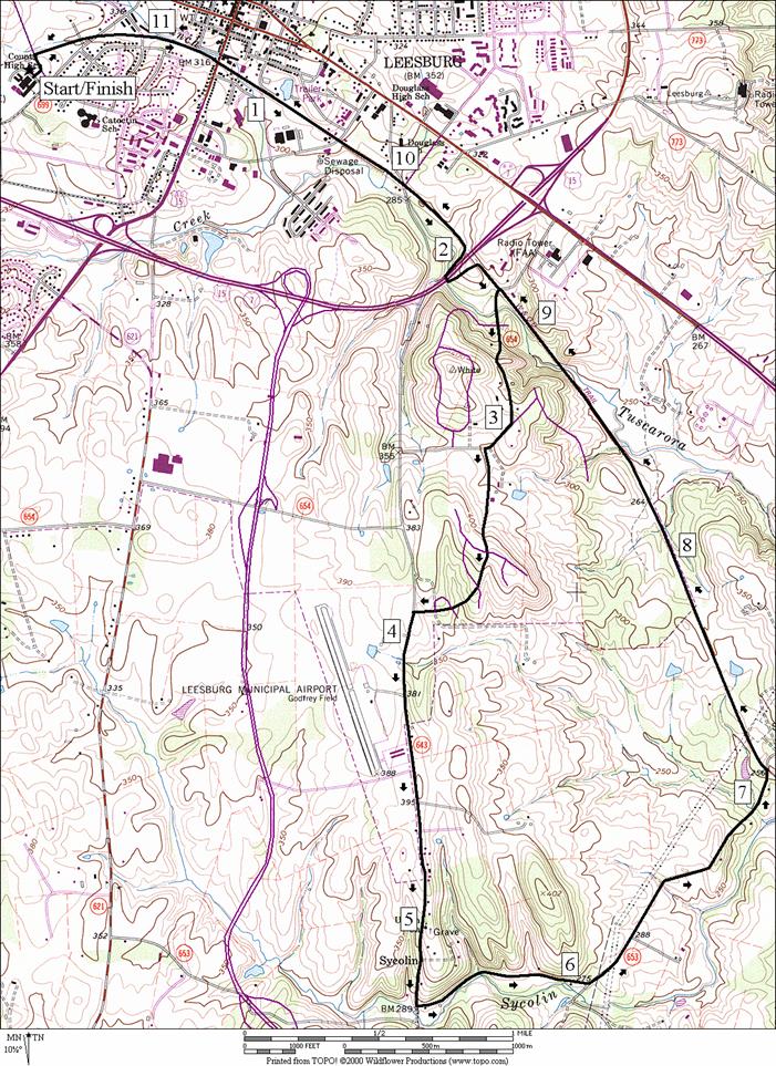
Cochran
Mill Road (11.6 miles, X)
For a long but flatter (not flat) run around Leesburg, head
east toward Ashburn on the W&OD Trail.
Cross a couple of intersections leaving town, the worst of which is the
eastern crossing of Catoctin Circle.
After going under the Leesburg Bypass, Rte. 15/7, turn off the trail
onto Lawson Rd. The road is paved at first but becomes gravel
as it climbs a steep hill. Pass
Cool Spring Elementary
School on Tavistock Dr.
and then cross a small ridge. The little
trail on the left on the ridge loops back to the Tavistock Dr. but doesn’t save
you from any hills. At Sycolin Rd.
use the shoulder and watch out for intermittent traffic. Sycolin Rd.
has gotten busier in recent years.
You’ll pass an airport on your right.
After a mile and a half, take Cochran
Mill Rd. along side Sycolin Creek. The pavement soon ends and you’ll find
yourself crossing farm fields before hitting the W&OD Trail. The way back gradually climbs a little at a time
into Leesburg. As an alternate, start
this route from Cool Spring
Elementary School for a shorter 6.8
mile loop.
Nearby and Connecting Zones
What to do Afterward
Food and Drink
Tuscorora Mill - at Market Station - 703 478-1141/703
771-9300
Scoopers Deli & Ice Cream Bar - at Market Station - 703
777-3317
Dell Rio’s - Mexican food w/comedy on Saturday nights - 703
777-9554
Southstreet - at Market Station - 703 771-9610
Laurel Brigade Inn - 703 777-1010
La Villa Roma - 703 777-6223
Entertainment and Edification
Leesburg - historic downtown
Morven
Park - home of Governor
Westmoreland Davis, Governor of Virginia from 1918-1922; open April 1BOctober 31 - 703 777-2414
Ida Lee
Recreation Center
- 703 777-1386
Thomas Balch Local History Library - 703 779-1328
Oatlands Plantation - built in 1803, historic landmark and
gardens - 703 777-3174
Balls Bluff Regional Park - 703 352-5900
Tarara Winery - Leesburg - 703 771-7100
Leesburg In Town
Distance: 4.25 miles
Rating: III; streets and sidewalks around and through
town; mostly sunny and slight hills
0.0 from
hydrant, go toward Dry Mill Rd
R 0.05 Dry
Mill Rd
L 0.25 Lee
Ave; becomes Davis at 0.5 miles
L 1.0 Wirt
St; becomes 1st St at bend in road to the right (1.2 miles)
L 1.25 King
St
1.35 Catoctin
Circle Rd
1.65 W&OD
Trail
1.8 Market
St, Rte 7
L 2.05 North
St
BR 2.15 Old
Waterford Dr
2.6 Rust
Library/Ida Lee Park (restrooms, water)
L 3.0 Fairview
St
3.6 Market
St, Rte 7; Fairview becomes Catoctin Circle
3.95 Foxridge
Park on R
XS 4.15 W&OD
R 4.2 into
Loudoun County HS
4.25 parking
at hydrant
Leesburg In Town
Thomas Mill Road
Distance: 9.15 or 9.35 miles
Rating: X; paved and gravel roads, railroad grade
trail; long steep climbs; mostly sunny
9.15
Mile Route
0.0 from
hydrant, go toward Dry Mill Rd
R 0.05 Dry
Mill Rd
0.25 Lee
Ave on L
0.6 begin
bridge over Rte 7 bypass
0.9 Woodburn
Rd on L
L 1.6 Thomas
Mill Rd, Rte 820; begin climbing long steep hill
2.6 Gore
La
3.05 top
of hill; views to the east
R 3.2 Canby
Rd, Rte 662 (unmarked)(gravel); downhill
BR 3.75 Digges
Valley Rd, Rte 707 on L at bottom of hill
4.05 Surreyfield
Way on L
4.9 top
of hill; begin pavement
CR 5.35 E
Colonial Highway , Rte 7; (!)
S 5.8 on
W&OD Trail; Charles Town Pike, Rte 9 on L; becomes Dry Mill Rd
<*
BL 5.9 W&OD
leaves the road
5.95 Mile
Marker 38.5
6.0 stone
arch for Dry Mill Rd
6.15 Dry
Mill Rd
8.0 stone
bridge
8.6 end
bridge over Harry Byrd Hwy, Rte 7
R 9.05 Catoctin
Circle
R 9.1 into
Loudoun County High School parking
9.15 fire
hydrant in parking lot

*9.35
Mile Route
S 5.9 on
Dry Mill Rd as W&OD leaves the road to the L
6.15 W&OD
Trail
7.85 Thomas
Mill Rd on R
8.45 Woodburn
Rd on R
8.7 begin
bridge over Rte 7 bypass
9.1 Lee
Ave on R
L 9.3 Dry
Mill Rd
9.35 fire
hydrant in parking lot
Old Waterford Road
Distance: 11.35 or 12.25 miles
Rating: X; dirt & gravel roads, paved
roads & paved trail; big steep hills; partly shady
11.35
Mile Route
0.0 from
hydrant, go toward Catoctin Cir
L 0.05 Catoctin
Circle
<*
XS 0.1 W&OD
0.65 W
Market St, Rte 7
L 1.25 Old
Waterford Rd
>*
1.55 Southern
Planter La on R
2.3 top
of hill
3.0 Nestlewood
Rd on R, Rte 755; bottom of hill at creek
3.9 Trotter
La on R; top of hill
L 4.75 Hurley
La, Rte. 703
5.45 top
of hill before pavement begins
L 6.2 Clark’s
Gap Rd, Rte 662; (! no
shoulder)
R 6.95 Charles
Town Pike, Rte 9
L 7.05 Simpson
Circle
L 7.2 W&OD
Trail
7.65 Mile
Marker 39
BL 7.7 trail
bears L at Simpson Circle
R 7.8 before
Charles Town Pike, Rte 9; to stay on W&OD Trail
L 8.05 at
T: Dry Mill Rd to stay on W&OD
L 8.15 W&OD
leaves Dry Mill Rd
8.25 stone
arch for Dry Mill Rd
8.4 Dry
Mill Rd
10.2 stone
bridge
10.75 begin
bridge over Harry Byrd Hwy, Rte 7
R 11.3 Catoctin
Circle
R 11.35 into
Loudoun County High School parking
11.35 fire
hydrant in parking lot

*12.25
Mile Route
R 0.1 W&OD
Trail
0.35 Dry
Mill Rd
0.5 Valley
View Ave
L 0.8 King
St
L 1.2 North
St
BR 1.3 Old
Waterford Rd
1.75 Rust
Library/Ida Lee Park (restrooms & water)
2.15 Fairview
St on L (pickup cues at mile 1.55 of 11.35 mile route)
Cochran Mill Road
Distance: 11.6 miles
Rating: X; paved trails, paved and gravel
roads; rolling hills; sunny
0.0 from
fire hydrant, go toward Catoctin Circle
L 0.05 Catoctin
Circle
R 0.1 W&OD
0.3 Dry
Mill Rd
0.4 Mile
Marker 35
0.8 King
St
1.0 Depot
St
1.35 Catoctin
Circle; (! no TL)
1.4 water
and restrooms at Douglas Community Center on L
1.65 Sycolin
Rd
2.15 underpass
Leesburg Bypass, Rte 15/7
R 2.4 Lawson
Rd (water)
R 2.95 Battlefield Pkwy
L 3.05 Tavistock Dr
3.2 Cool
Spring Elementary School
on R
3.45 trail
X on L (paved)
3.55 trail
X on L (paved)
L 3.9 Sycolin
Rd; (! traffic)
4.3 Leesburg
Town Limits
L 5.35 Cochran
Mill Rd; before creek
BL 6.05 at
Gant La on R to stay on Cochran Mill Rd
6.95 bridge
over creek
L 7.15 W&OD
Trail
7.3 Mile
Marker 31 (under power lines)
7.7 stone
bridge supports
8.1 Leesburg
City Limits
8.8 Tuscorora
Creek (trail dips)
9.2 Lawson
Rd (water on R)
9.45 underpass
Leesburg Bypass, Rte 15/7
9.9 underpass Plaza St
10.2 water
and restroom at Douglas Community
Center on R
10.25 Catoctin Circle;
(! no TL)
10.6 Depot St
10.8 King St
11.2 Mile
Marker 35
11.25 Dry Mill Rd
CL 11.5 Catoctin
Circle
R 11.55 into
Loudoun County
HS parking
11.6 parking
at fire hydrant