Purcellville
The end of
the line for the Washington & Old Dominion Trail (W&OD) (currently) is
in Purcellville. Forty-five miles east on the trail is Shirlington, a vastly
different place. Instead of the busy Interstate 95 traffic and dense housing,
you’ll find in Purcellville a relatively small town (this is changing). It has churches, small restaurants, and a Main
Street that you could identify without reading
the street signs. Were you to make the trip out and back in a day on bike, a
near century ride, you’d see on the W&OD, one city blend into another, one
suburb meld into another, and one field fuse into another. Running between
Paeonian Springs and Purcellville is like saving some of the best for last. The
paved W&OD Trail previously ended in Leesburg. Though it ends in
Purcellville now, an extension may take it even 2.4 miles more to Round Hill.
Though funding for this was applied for by the town of Round Hill in
1999 it was not awarded by the state. They haven’t given the idea up yet
however.
Getting
There
From the
Capital Beltway
Take Exit
12, for the Washington Dulles Access and Toll
Road, Rte. 267, west. When getting on to the
expressway, stay to the outer (right) lanes. The inner (left) lanes are only
for access to Washington Dulles International Airport. After 12
miles, just past Sully Rd., Rte. 28,
a second toll must be paid to continue on Rte. 267; from here called the Dulles
Greenway. Follow the Dulles Greenway approximately 12 miles further, to
Leesburg. Head West on the Rte. 7 bypass toward Winchester.
Approximately 7 miles past Leesburg, exit for Purcellville and turn left at the
stop sign on Berlin Turnpike, Rte. 287. Turn right on Colonial
Hwy., Rte. 7 Business, into town. One and a quarter
miles later, turn right on Hillsboro
Rd., Rte. 690. Park near the museum and
visitor center on the right. The trail is directly behind the building.
Area
Routes
Paeonian
Springs (12.35 miles, X)
Leaving
Purcellville, at first the way is flat. After crossing to the other side of the
Harry Byrd Hwy., Rte. 7,
the trail starts descending steadily. Most of this is in the trees, however
views occasionally open up to the north, on the left side of the trail. After
the third mile out from Purcellville, bottom out and leave the W&OD at Hamilton
Station Rd., Rte 704. Take Irene
Road,
which is somewhat flat and sunny to Meadowlark Dr. Meadowlark is still sunny
but is hilly and somewhat stark. Use Simpson
Circle (an alternate starting point) in Paeonian
Springs to join the trail again for the return trip. Miles 39 and 40 of the
W&OD Trail (back toward Hamilton
Station Rd.) can be breathtaking. The trees form a
long tunnel. Ralph Keith, a
member of
the Loudoun Road Runners suggested the loop portion of this route.
Nearby
and Connecting Zones
Leesburg
Taylorstown
What
to do Afterward
Food and
Drink
Fran’s
Place - 540 338-3200
White
Palace Restaurant - 540 338-3200
Pen
Oriental Kitchen - 540 338-1894
Purcellville
Inne - 540 338-2075
Entertainment
and Edification
Purceville Visitor Center and
Museum
Old Waterford
Tarara
Winery - Leesburg - 703 771-7100
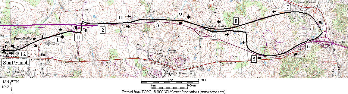
Paeonian Springs
Distance:
12.35 miles
Rating: X;
mostly shady paved trail with some sunny paved roads
R 0.0 from
Hillsboro Rd, Rte 690,
take the W&OD Trail east
0.15 Mile Marker 45
0.2 Hatcher
St; portable outhouse & parking
0.9 Maple
Ave
1.25 W&OD Trail
joins Hirst Rd
1.3 Mile Marker 44
CL 1.4 at
T; Berlin Turnpike,
Rte 287
1.55 underpass Harry
Byrd Hwy, Rte 7
R 1.65 W&OD
Trail
2.1 Mile Marker 43
2.8 Ivandale
Rd, Rte 709
3.1 Mile Marker 42;
bottom of grade
R/L 3.8 R on
Hamilton Station Rd, Rte 704;
L on Irene Rd (use
shoulder)
R 4.55 at
T; Meadowlark Dr, Rte 800
5.15 Quail
Creek Circle on L
5.35 Quail
Creek Circle on L
R 6.0 Simpson Circle
L 6.3 W&OD
Trail (tunnel through the trees!)
6.75 Simpson
Circle
7.3 Mile Marker 40
(tunnel through the trees!)
8.3 Mile Marker 41
8.55 Hamilton
Station Rd, Rte 704
9.25 Mile Marker 42;
bottom of grade
9.55 Ivandale
Rd, Rte 709
10.25 Mile Marker 43
L 10.7 at
T; Berlin Turnpike,
Rte 287
10.75 underpass Harry
Byrd Hwy, Rte 7
CR 10.95 Hirst
St; to stay on W&OD Trail
11.1 W&OD Trail
leaves Hirst Rd
11.2 Mile Marker 44
11.45 Maple
Ave
12.16 Hatcher
St; portable outhouse & parking
12.2 Mile Marker 45
L 12.35 Hillsboro Rd, Rte
690
Paeonian Springs