Taylorstown
History
goes back a long way in Loudoun County and
Taylorstown is one of the county’s oldest settlements. State historical markers
say the estate of Hunting Hill dates back to 1737, Foxton Cottage, in the
mid-eighteenth century, and Taylor’s Mill
built circa 1800. The area situated off of Catoctin Creek, also originally had
fieldstone construction houses built by German Quaker
descendants.
In the Civil War, despite being part of the south in Virginia, these
same people were loyal to the Union, hence
Loyalty, the name of the region. The area today is about as rural as it gets
anywhere in eastern Virginia. Located
in-between ridges east (Catoctin Mountain) and west
(Short Hill Mountain), and the
Potomac River to the north, the area gets little car traffic.
Getting
There
From the
Capital Beltway
Take Exit
12, for the Washington Dulles Access and Toll
Road, Rte. 267, west. When getting on to the
expressway, stay to the outer (right) lanes. The inner (left) lanes are only
for access to Washington Dulles International Airport. After 12
miles, just past Sully Rd., Rte. 28,
a second toll must be paid to continue on Rte. 267; from here called the Dulles
Greenway. Follow the Dulles Greenway approximately 12 miles further, to
Leesburg. Head West on the Rte. 7 bypass toward Winchester.
Approximately 3 miles past Leesburg, exit and turn right at the stop sign on Charles
Town Pike, Rte. 9. Go to the bottom of the hill and turn right onto Clarks
Gap Rd. Go about 2.7 miles into Waterford where you
can bear right on Butchers Row. As you pass the
school
following the road around the curve to the left, the road becomes Loyalty
Rd, State Rte. 665. Follow Loyalty
Rd. approximately 7.5 miles to a T
intersection at Taylorstown. Turn left at the intersection onto Taylorstown
Rd, State Rte. 663. After crossing Catoctin
Creek, turn left and park on the gravel area besides the road before the
intersection with Downey Mill Rd.
Rte. 663.
Area
Routes
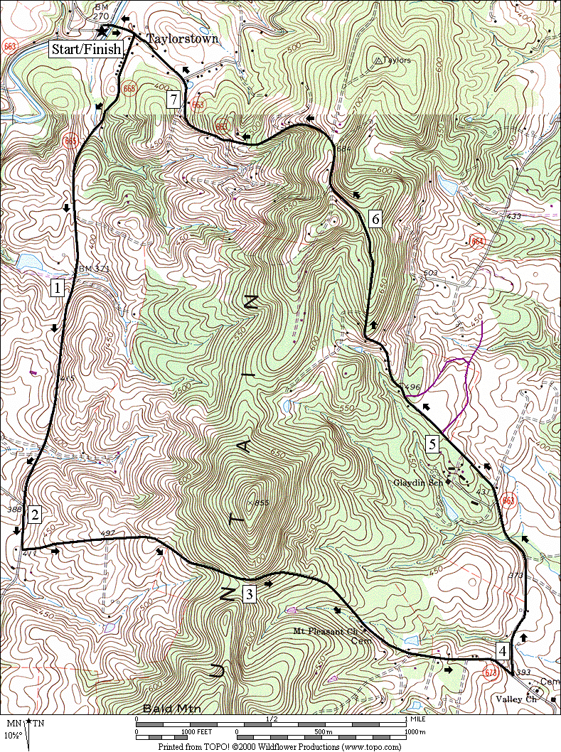
Bald Hill Road (7.4 miles, X)
Always
beware of running routes with “hill” in the name. This route has two basic
hills. The first climbs over then down the other side of a mountain. The second
one climbs back over, and back down the mountain. Along the way, it also has a
few other rolls, twists and turns. If you’re used to running mountains like
Brush Mountain, or Price Mountain, or coming out of Ellett
Valley on Harding
Avenue near Blacksburg Virginia (all of
which the Virginia Tech Cross Country team train on) this will be just another
good workout. On the other hand... you’re better off skipping this one if you’re
not ready for it.
Start by
crossing the creek and climbing toward Taylorstown. Turn right on Loyalty
Rd. The rolling hills will warm you up quickly
but the fun is only beginning. Notice the long black fence and pastures on the
right. This is the former Firestone Ranch; as in the tire company. You will pass
Featherbed Road (State
Rte. 673) on the right and soon after, you will see the dirt and gravel
Bald
Hill Road (also State Rte. 673) on the left. Take
the left up Bald Hill Road. For a
road, it’s narrow, lightly traveled, and largely uninhabited. It is a public
road however. It climbs Catoctin Mountain about 250
vertical feet over 0.9 miles in 3 stages. Going down the other side it drops 260
feet over 1.1 miles to the paved New
Valley Road and Taylorstown road intersection.
Following Taylorstown
Rd., climb gradually at first, then more
steeply when the pavement ends. After
1.9 miles you will have gained 320 feet. Enjoy the obstructed views at the top
of the hill, but don’t blink or you will miss Taylorstown on the way down. The
road drops 430 feet over the final 1.3 miles to Catoctin Creek. Ralph Keith, a former
member of the Loudoun Road Runners
provided
the suggestion for this loop.
Nearby
and Connecting Zones
Leesburg
Purceville
C&O Canal, Edward’s Ferry
What
to do Afterward
Food and
Drink
picnic
Entertainment
and Edification
Purceville Visitor Center and
Museum
Old Waterford
Tarara
Winery - Leesburg - 703 771-7100
Bald Hill
Road
Distance:
7.4 miles
Rating: X;
paved and gravel rural roads with long and steep climbs; mostly sunny
R 0.0 from
the parking area on Taylorstown Rd
0.05 end bridge over
Catoctin Creek
R 0.1 Loyalty Rd, Rte 655
1.95 Featherbed Rd on
R, Rte 673
L 2.1 Bald
Hill Rd, Rte 673; begin climbing on the gravel road
3.0 top of hill;
driveway on L
3.5 church
3.7 Browns Farm La on
R
L 4.05 Taylorstown Rd, Rte 663
4.7 Glaydin camp on L
5.0 Barnhouse
Pl on R
BL 5.3 at
X; Rte 664 is on R; road becomes gravel and climbs steeply
5.9 top of steep section
6.0 top of hill
6.15 Goodhart La on L
6.65 road becomes paved
7.05 Furnace
Mtn Rd on R
7.3 Loyalty
Rd, Rte 665, on L
7.35 begin bridge over
Catoctin Creek
L 7.4 parking
Bald Hill Rd.