Trailside Park, Ashburn
For an outsider, Ashburn might seem like a follow-up act to Reston. It’s a large planned community built at the
time, outside the known limits of civilization... Vast farm fields however changed over to
become homes for people who were fleeing that so called civilization. Though a part of Ashburn is old, most of it
is new and is still changing. It’s got
its own character. Corporate giants such
as AOL and MCI Worldcom now dominate Ashburn. The Washington
and Old Dominion Trail (W&OD) passes right through it, though you’d hardly
know from being on it. Buffers zones around the trail still make you
feel alone out in the country. The trail
is an obvious choice for out and back routes.
Most of the other parks near Ashburn are ones that were built as part of
the planned development. The parks and
trails within them follow riparian settings.
As of the year 1999, Ashburn was still out by itself enough to take
advantage of running loops on country roads.
Gravel roads are quickly becoming paved in this fast growing county so
hurry. Trailside
Park is small and new. Ballfields and other amenities have been
built in it. Some of the routes shown
here were contributed by Ralph Keith, formerly a member of the Loudoun Road
Runners.
Getting There
From the Capital Beltway
Take Exit 12, for the Washington Dulles Access and Toll
Road, Rte. 267, west. When getting on to the expressway, stay to
the outer (right) lanes. The inner
(left) lanes are only for access to Washington
Dulles International
Airport. After 12 miles, just past Sully
Rd., Rte. 28, a second toll must be paid to
continue on Rte. 267; from here called the Dulles Greenway. Approximately 5 miles further, take Exit 5,
for the Claiborne Pkwy. Turn right at the stop. After approximately 2 miles, at what is
currently the end of the road, turn left and park in Trailside
Park. Start from the trail head that goes toward
the wooden bridge in the woods and the W&OD Trail.
Area Routes
Ashburn
Park (3.2 miles, II)
Explore the trails of Ashburn Farms on this route, then
return on the W&OD. At first, you’ll
have your right foot in the suburbs, and the left in the country. On the right are houses, and on the left as
you parallel the obscured W&OD, are farm fields. After crossing the Hay
Rd. start descending and intersect some
trails. Though the trail intersections
are not marked; just remember to turn left at all trail intersections, keeping
the W&OD to your left. Soon you’ll
arrive at Ashburn Park
where the paved trail ends and the confluence of several streams is
located. Pop up a short gravel road to
the older parts of Ashburn. Following
paved roads, join the W&OD at Ashburn Rd.
where a popular general store sells cold drinks. The way back on the W&OD is mostly a long
straight downgrade. Turn left at the
first opportunity, just before an in-line hockey rink. The W&OD is appropriate for in-line
skating however most of the Ashburn trail are not.
Beaverdam
Run (4.25, 2.05 or 2.55 miles, III, II or II)
After learning the trail to Ashburn
Park, you might want to checkout
some of the side trails on that route.
The longest route described here goes to Beaverdam Run. A trail along Beaverdam Run went for a mile
and a quarter in 1999 before ending at construction. Return instead on a trail that takes you to Claiborne
Pkwy. then go along it to return to Trailside
Park. The shortcuts follow streams and climb steep
but not long hills before coming back to Claiborne
Pkwy.
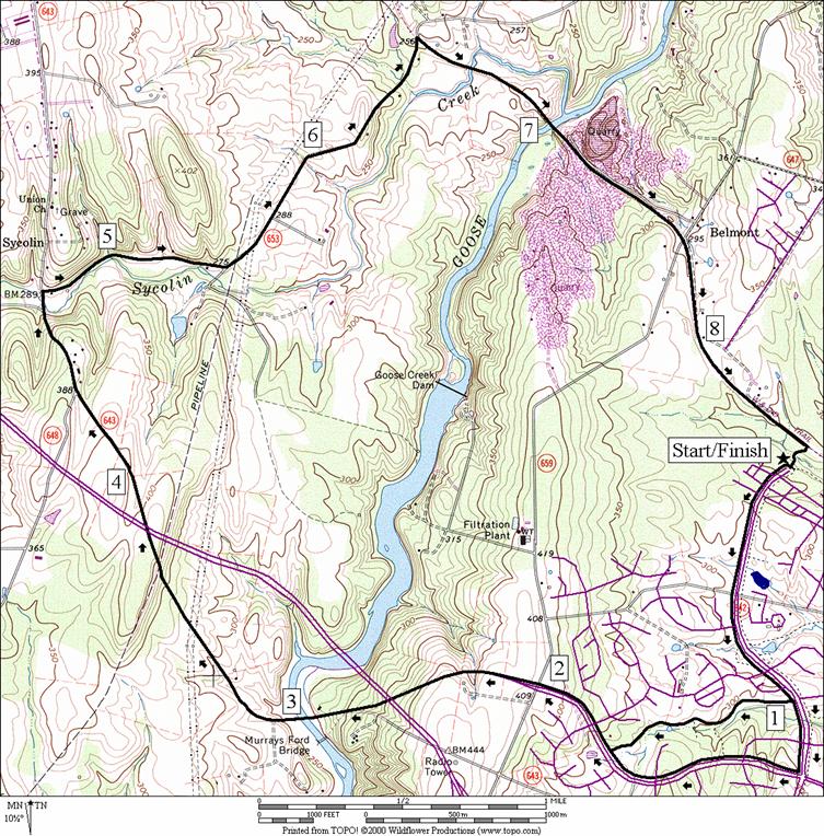
Sycolin
Road (8.65 or 8.95 miles, X)
Leaving Trailside Park take a right onto Claiborne Pkwy.,
cross Hay Road, and then either use paths along the road or paths behind the
houses get to Ashburn Farms Pkwy. The
hill going up Ashburn Farms Pkwy takes you to the top of Belmont Ridge, and
will warm you up (125 ft. over a distance of 1 mile). Once across Belmont
Ridge Road at the top, Ashburn Farms Parkway
becomes Sycolin Road (State
Rte. 643), civilization disappears, and the road quickly becomes gravel (note
this area is changing and one day may handle significant auto traffic). Proceed along Sycolin, over the Dulles
Greenway, down the big hill to Goose Creek
(160 ft. over 0.85 miles). Go up two
more less vigorous hills ahead. After a
few miles cross Sycolin Creek and take a right on Cochran Mill Road (State Rte.
653). Cochran Mill road is mostly a
gravel road over flat to rolling hills.
Take a right at the W&OD and continue, crossing Belmont
Ridge Road (State Rte. 659). Turn right at the path into Ashburn Farms and
Trailside Park
(after the in-line skating hockey rink).
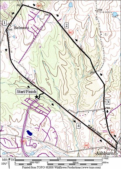
Stubble
Road (4.65 miles, IV)
Leave Trailside
Park and Claiborne
Pkwy. onto the paved trail to the W&OD Trail.
Take a left on the W&OD Trail and run along the trail to Belmont
Ridge Road.
Use caution, the 0.4 miles uphill on Belmont
Ridge Road can be busy with occasional heavy truck
traffic. There are no shoulders. It has a posted speed of 45 mph, but traffic
usually goes faster. Turning off onto Stubble Road,
the way is much better. Neither cars nor
even houses are to be seen. The wooded
stretch with easy rolling hills is especially pleasant in the fall. (as of
1999, most of Stubble Road
is gravel and wood covered, however new housing developments are changing
that). Stubble road ends at Ashburn Rd.
Take a right onto Ashburn Road
and another quick right onto the W&OD. Continue on the long straight the
bike trail until you see the path on the left back to Trailside
Park.
Nearby and Connecting Zones
Washington & Old
Dominion Park,
Sterling
Leesburg
Food and Drink
Manhattan
Pizzaria - 703 858-1388
Lansdowne - 703 729-8400
House of Emperor - 703 729-1411
Ashburn Bagel Shop - 703 858-5799
Entertainment and Edification
Brambleton Regional
Park 703 - 327-3403
Algonkian Regional
Park - 703 450-7655
Balls Bluff
Regional Park
- 703 3525900
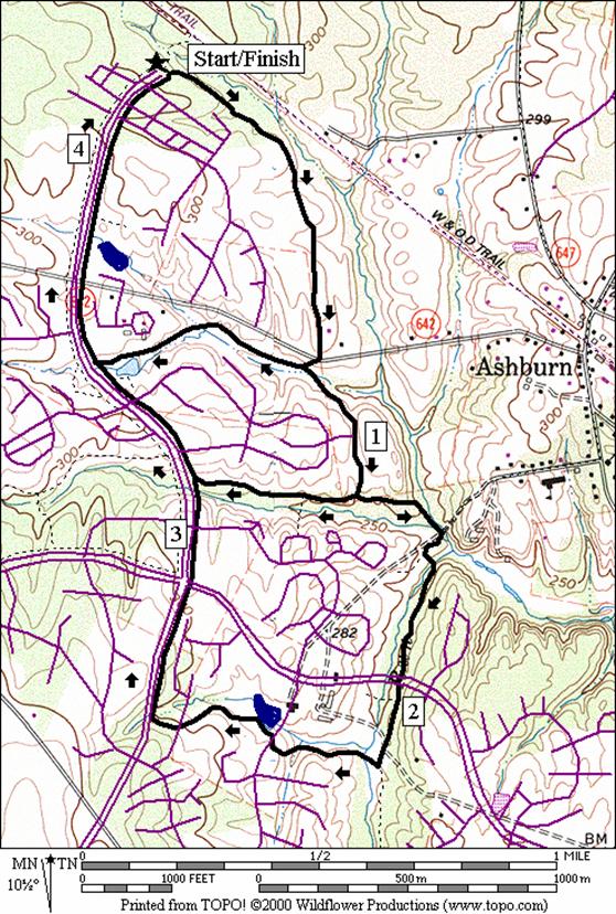
Ashburn Park
Distance: 3.2 miles
Rating: II; paved trails with short segments on gravel
& paved road; mostly sunny and flat
0.0 from
the park; cross Claiborne Pkwy
to the trail head directly across
0.45 court
on R
0.8 cross
Hay Rd
L 0.85 trail
X; sharp L on the downhill
1.0 Cross Breeze Place
L 1.15 at
T; trail X (unmarked)
L 1.4 trail
X on L; S & L are to bridges
1.45 trail
X on L after crossing creek; go up the hill; playground on L; Ashburn
Park
S 1.6 on
Partlow Rd at Preddy
Ct on L
L 1.8 Ashburn
Rd; use sidewalk
2.0 Hay Rd on L
L 2.05 W&OD
(store)
2.35 Mile
Marker 28
L 3.15 trail
X on L; to Trailside Park
3.2 Trailside
Park at Claiborne
Pkwy
Ashburn Park
Beaverdam Run
Distance: 4.25, 2.05 or 2.55 miles
Rating: III, II or II; paved trails along
small parks; some small hills
4.25
Mile Route
0.0 from
the park; cross Claiborne Pkwy
to the paved trail head directly across
0.45 court
on R
0.8 cross
Hay Rd
<*
L 0.85 trail
X; sharp L on the downhill (unmarked)
1.0 Cross Breeze Place
<**
L 1.15 at
T; trail X (unmarked)
BR 1.4 trail
X on L; S & L are to wood bridges
L 1.45 trail
X on L (unmarked); next wooden bridge is over Beaverdam Run
1.75 trail
X on L before tunnel (unmarked); goes to Ashburn Farm
Pkwy
2.0 trail
X on R (unmarked) goes over Beaverdam Run
R 2.1 trail
X on R (unmarked); goes over Beaverdam
Run
R/L 2.3 at Windmill
Dr to stay on trail; pond at visitor center
BL 2.4 at
trail X to leave pond
BR 2.65 Windmill Dr at
Cornerpost Sq
R 2.7 Claiborne Pkwy
2.95 Ashburn
Farm Pkwy
3.2 trail
X on R (unmarked)
>**
3.5 trail
X on R (unmarked) is cloverleaf to cross under Claiborne
Pkwy
3.55 trail
X on R (unmarked)
>*
3.75 Hay Rd
3.85 trail
X on R (unmarked) to ballfields
CL 4.25 at
Grey Swallow Terr on R; end of Claiborne Pkwy
4.25 Trailside
Park; trail X on R to W&OD trail

*2.05
Mile Route
BR 0.85 merge
at trail X (unmarked)
R 1.3 Claiborne
Pkwy (pickup cues at mile 3.75 on 4.25 mile route)

*2.55
Mile Route
R 0.85 at
T; trail X (unmarked)
1.3 trail
X on L through woods to houses
R 1.5 Claiborne
Pkwy at top of short steep hill (pickup cues at mile 3.5 on 4.25 mile route)
Sycolin Road
Distance: 8.65 or 8.95 miles
Rating: X; paved trails, paved and gravel
roads; some big and steep hills; mostly sunny
8.65
Mile Route
R 0.0 Claiborne Pkwy
from the park
0.5 Hay Rd
0.7 trail
X on R (unmarked)
0.75 trail
X on R (unmarked) goes to tunnel under Claiborne Pkwy
<*
R 0.95 trail
X on R (unmarked)
1.15 trail
X on R (unmarked)
1.3 trail
X on L to Ashburn Farms Pkwy
1.35 trail
X on L to Ashburn Farms Pkwy
R 1.7 Ashburn
Farms Pkwy at T
>*
2.05 Belmont
Ridge Rd; Ashburn Farms Pkwy becomes Sycolin
Rd, Rte 643
2.45 begin
bridge over Dulles Greenway
2.9 begin
bridge over Goose Creek
3.45 high
tension power lines
3.7 gas
pipeline on hill
3.9 end
bridge over Dulles Greenway
R 4.75 Cochran
Mill Rd after crossing Sycolin Creek
BL 5.45 at
Gant La on R to stay on Cochran Mill Rd
6.35 bridge
over creek
R 6.5 W&OD
Trail
6.75 end
bridge over Sycolin Creek
6.85 Mile
Marker 30.5
7.1 end
bridge over Goose Creek
7.25 Luck
Stone Quarry overlook on R
7.55 quarry
road
7.7 Belmont
Ridge Rd
8.35 Mile
Marker 29
R 8.55 trail
X on R to Ashburn Farms and Trailside
Park (unmarked)
8.65 Trailside
Park at Claiborne
Pkwy
*8.95
Mile Route
0.95 trail
X on R (unmarked)
R 1.3 Ashburn Farm Pkwy
1.55 trail
X on R (unmarked) before Sander’s Corner
Elementary School
2.0 trail
X on R (unmarked) (pickup cues at mile 2.05 on 8.65 mile route)
Stubble Road
Distance: 4.65 miles
Rating: IV; paved trails, paved and gravel
roads; modest hills; half sunny/half shady
0.0 from
Trailside Park,
take the trail head to the W&OD Trail
L 0.1 W&OD
0.3 Mile
Mark 29
R 0.95 Belmont Ridge Rd
(Rte 659) (!)
R 1.35 Stubble Rd
1.6 Alexander’s
Corner Rd on R
R 3.45 Ashburn Rd
R 3.5 W&OD
(store)
3.8 Mile
Marker 28
L 4.6 trail
X on L; to Trailside Park
4.65 Trailside
Park at Claiborne
Pkwy
Stubble Road