![]()
*
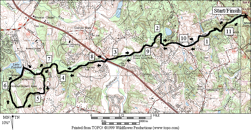
S 0.9 Ridge Trail on L goes up steep hill
1.05 trail X
U 1.1
1.15 trail X
1.3 Ridge Trail on R goes up steep hill (pickup cues at mile 3.95 on 4.4 mile route)
Difficult
The more intense mountain bikers have known about for
Difficult Run for some time. Equestrians
have known it longer. Eight miles of
unpaved trail, the Rails to River Trail (RRT), along creeks connects
Getting There
From the Capital Beltway, I-495
Take Exit 13, for Georgetown Pike, Rte. 193, west. After 3.6 miles, turn left into the parking
area. As you turn left into the gravel
lot, the trail head going south crosses the creek on your right (on stepping
stones). The way to the
Area Routes
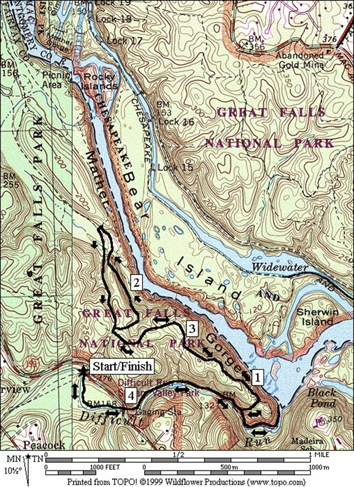
River and Quarry (4.4 or 2.2 miles, IV, or II)
For those not ready to test themselves on the way south, a
more modest challenge can still be had by going north toward the Potomac River
and into Great Falls Park. The first
third of a mile is somewhat flat and on the dirt RRT. The trail splits and merges on parallel paths
as a result of people trying to avoid the puddles of the flood plain. After crossing under Georgetown Pike, follow
the gravel trail downward. You’ll drop
about 100 feet over the next 0.7 miles if you go all the way to the river. For the longer route, turn left before
getting to the river, up a short but steep gravel path to the Ridge Trail. On the ridge, you’ll roll over hills but
mostly climb to the
Wet Run might be a more appropriate name for this
route. The trail stays wet long after
rains have past. Don’t try it if
thunderstorms threaten because you must cross the creek without benefit of
bridges several times and the waters can get higher. Previously named the Difficult Run Trail, the
trail is now named the Rails to River Trail.
It connects the
Bikers with gusto go right to work on this by leaving the
parking lot and splashing their way across Difficult Run. It takes a head of speed and some skilled
steering to get across because the water is over a foot deep in places. If you’re running, you might be able to avoid
getting wet just yet. The less
enthusiastic can rock hop their way across if the water is low enough and if
the rocks, well placed by other passers-by, have not been washed away. Just over a quarter mile upstream, a second
crossing must be made. On this one, you’ll
have the benefit of concrete underfoot.
You might be able to jump over the deepest of the water but watch out
for it being slippery underneath. The
way is flat for the next thee tenths of a mile.
Look for a third crossing a hundred yards past the remnants of an old
cabin. The crossing is identified by a
muddy gully dropping into the water, and the crossing is sharply to the
left. If you miss it you’ll run into
private property. On this crossing, the
downstream angle of approach keep you in the shallows but lengthens the
crossing. You can’t avoid getting wet,
unless your on a bike.
For the next 1.7 miles, there are no creek crossings and the way
continues to be mostly flat. You’ll pass
Ramey’s
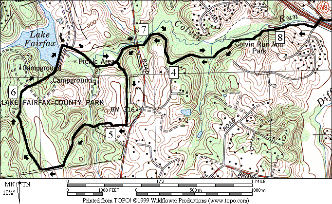
At Leesburg Pike, Rte. 7, cross at a traffic light and begin following Colvin Run. The trail starts climbing more from this point on the way to Lake Fairfax Park. It remains wooded. In Lake Fairfax Park, follow the RRT past the picnic area and fields until you intersect a nature trail identified by red blazes. The nature trail takes you through a campground where you can get a drink. Continuing on, cross the Lake Fairfax dam. Snacks and drinks can be purchased at the pool near the dam. Turning right after the dam, go through a picnic area and return on the RRT. The route through Lake Fairfax Park is hilly. . Return from the picnic area, down Colvin Run and Difficult Run on the RRT.
Nearby and Connecting Zones
What to do Afterward
Food and Drink
Café Oggi - 703 442-7360
Greek Taverna - 703 556-0788
Kazan Restaurant - 703 734-1960
picnic
Entertainment and Edification
Great Falls Grange & Old Schoolhouse - assembly hall & one room school house - 703 938-8835
Colvin Mill - off Leesburg Pike - 703 759-2771
Meadowlark Gardens - 703 255-3631
Distance: 4.4 or 2.2 miles
Rating: IV or II; paved trail on the shorter route; roads and hill on the longer one; sunny
0.0 south from parking lot, through the gate; Rails to River Trail (RRT); go downstream & do not cross creek
0.35 underpass Georgetown Pke, Rte 193
BR 0.4 onto road-like gravel trail; Difficult Run Trail/RRT
0.45 trail X on L
<*
L 0.9 Ridge Trail(steep gravel trail)
L 0.95 at T to stay on Ridge Trail
1.1 coral for horses
1.45 River Trail on R (no bikes)
1.7 trail X on R
BR 1.75 before Carriage Rd & stairs on L
R 1.8 Matildaville Trail (no bikes)
2.05 trail X on R to River Trail
L 2.15 at T (unmarked)
UL 2.25 just
past the quarry;
BL 2.6 to Ridge Tr; Matildaville Tr on L
BL 2.65 Ridge Trail
2.7 trail X on R
2.95 River Trail on L (no bikes)
3.3 coral for horses
R 3.45 down to RRT/Difficult Run Trail; (!)
R 3.5 RRT/Difficult Run Trail
>*
3.95 trail X on R
BL 4.0 RRT on L; R is to road
4.05 underpass Georgetown Pke, Rte 193
4.4 parking & trail crosses creek on L
![]()
*
S 0.9 Ridge Trail on L goes up steep hill
1.05 trail X
U 1.1
1.15 trail X
1.3 Ridge Trail on R goes up steep hill (pickup cues at mile 3.95 on 4.4 mile route)
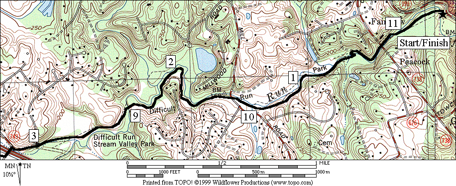
Distance: 11.35 miles
Rating: X; shady, often muddy trails w/wet creek crossings; mostly flat, but hills midway
CR 0.0 from parking lot cross Difficult Run on stones (!); go upstream
0.35 cross Diff Run on wet concrete (!)
0.4 underpass
0.6 old cabin
L/R 0.65 sharp L at muddy gully; angle downstream to cross Diff Run (!); no bridge (time to get wet)
0.75 trail X on L
0.8 rocky outcrop
1.05 cross stream past house w/chimney
1.15 trail X on L to house
1.45
1.75 trail X on L
2.4 cross Diff Run on stones (!); gravel rd
2.95 concrete bridge; begin paved road; horse trail turns L
L 3.1 Colvin Mill Rd;
CR 3.15 cross Leesburg Pike, Rte 7; road becomes Carpers Farm Way; R to continue RRT
3.8 wooden bridge
4.05 wooden bridge
4.1 trail X on R
4.4 Hunter
Mill Rd;
L 4.5 at split to follow horse trail
4.55 park road X; start climb ahead
R 4.95 field at the hilltop; R at the fence
5.0 trail leaves the field; down to creek
5.1 trail on R merges before xing creek
5.3 trail on L merges
5.45 trail X on R
5.5 soccer fields; follow horse trail signs
R 5.6 trail X upon entering woods; Nature Trail; red and white blazes
R 5.9 gravel road at campground; C-34
6.0 gravel road X on L; water/restrooms
6.25 through the gate closing the road to the lake
R 6.45 after xing the dam, go across grass & to road going down to the picnic area
L 6.65 onto gravel rd after xing Colvin Run
BR 6.7 at split in the road; toward pavilion
L 6.8 gravel road is the RRT
BR 6.85 trail X on L merges; leave picnic
6.95 Hunter
Mill Rd; leave
7.25 trail X on L
7.3 wooden bridge
7.55 wooden bridge
L 8.2 Carpers
Farm Way; cross Leesburg Pke, Rte 7; becomes;
R 8.25 unmarked service road
8.4 horse trail on R before concrete bridge; follow gravel road S
8.95 cross Diff Run on stones (!); dirt trail
9.6 trail X on R
9.9
10.2 trail X on R to house
10.3 cross stream before house w/chimney
10.6 rocky outcrop; trail X on R afterward
L/R 10.7 angle upstream to cross Diff Run (!); no bridge (time to get wet again)
10.8 old cabin
10.95 underpass
11.0 cross Diff Run on wet concrete (!)
L 11.35 cross Diff Run on stones (!); parking