Great Falls National Park, Virginia
Despite having grown-up in the area, I had not seen Great
Falls until I was near an adult. I used to think places like Great
Falls only existed someplace else that you went to go
on vacation to see. Some are still undecided
on whether I=m an
adult or not but I sure feel fortunate to have Great Falls
so close by. The waters tumble 76 feet
over the space of about half a mile. The
drop confounded people like George Washington who dreamt of transportation and
commerce on the Potomac River. The dreamers of his day did something about
it by building canals on both sides of the river; at Great
Falls, and in other places. The longer and more famous Chesapeake
and Ohio Canal
was built in Maryland. The Potowmac
Canal was built on the Virginia
side of the river and passes through Great Falls. The Potowmac
Canal was active from 1785 to 1828
but it wasn’t completely finished until 1802.
Restoration efforts have been underway to reset the lock stones on the
eroded hillsides. If you have time, hike
the River Trail. It’s much too rocky to
consider running it, but you’ll get great views of Mather Gorge, an east coast
equivalent of a canyon. The rock walls drop vertically 50-100 feet straight
into the river while the river is compressed to a width hardly more than 100
feet across in some places. Climbers and
kayakers of all skill levels take pleasure on the walls and in the water
(sometime both). Great
Falls is very busy on weekends and there is a modest
fee to enter the park. Come early to
ensure that you can get in. North and
adjacent to Great Falls National
Park is Riverbend
Park, a Fairfax
County park. You can watch the river tumble over lessor
boulders there but also find quieter places for contemplation.
Getting There
From the Capital Beltway, I-495
Take Exit 13, for Georgetown Pike, Rte. 193, west. After four and a quarter miles, turn right at
the stoplight onto Old Dominion Dr.
and into Great Falls National
Park. Near
the bottom of the long hill, pay the entrance fee and continue straight. Park in the lot one-tenth of a mile ahead on
the right, near the Visitor Center. Start from the crosswalk on Old
Dominion Dr.
Area Routes
Old
Carriage Road (3.0, 1.8 or 2.8 miles, II, I, or II)
For a quick introduction to the area, follow the bluestone
path along Old Dominion Rd toward the entrance gate. Bear left with it as it curves away from the
paved road and widens. Where it leaves
the road, is where the Old Carriage Rd. begins.
There are many branching trails going to and from parking lots and the
fall view points. Stay along the widest
path and generally keep straight. Follow
the signs toward the restrooms, then bear right after them at the intersection
with the Matildaville Trail on the left.
You’re still on the Old Carriage Rd.
at this point. Options to shorten the
route are at left turns at the next two intersections with the Matildaville
Trail (no bikes). If you go to the
second left turn, you’ll be able to see a little of the Mather Gorge, some of
the remains of the Potowmac Canal,
a quarry. The shorter and longer return
routes on the Matildaville Trail pass by the ruins of Matildaville itself, an
old settlement that the park brochures describe as having been sponsored by
Lighthorse HarryBa
revolutionary war hero and friend of George Washington. Preservation efforts are underway for
Matildaville. The longest route skips
the Matildaville Trail altogether.
Instead it climbs moderately on the Ridge Trail to Old Dominion Drive
and returns on the road. There are no
shoulders to the road so you’ll need to keep an eye and ear open for
traffic. The 3 mile version of this
route can be ridden by mountain bike.
Weant Drive
(2.65 miles, II)
Going past the end of the paved Old Dominion Drive, you
leave the national park on a gravel road going into River Bend Park. Several park trails branch off along this
road. At the top after a climb of 150
vertical feet in seven tenths of a mile, turn right at a T-intersection onto
Weant Drive. The quiet drive descends
the 150 feet in less than half a mile to the river. Where it reaches the water can be seen Conn
Island. Though the island has a name
that makes it sound like the latest blockbuster, its fame was a factual
drama. A park placard indicates
President James Madison having sought refuge there on August 25, 1814. He took a ferry there from Montgomery County
while trying to flee the British who had set to burning the Capitol. The way to run back from here is on the
Potomac Heritage Trail. Pass the
aqueduct dam that is the means of withdrawing much of Washington,
D.C.’s and Arlington’s
drinking water from the Potomac. The trail gets rocky near the dam. Follow a bumpy gravel road back to Old
Dominion Drive and the Visitor Center parking area.
Riverbend
(5.2 or 3.95 miles, V or IV)
Less explored than in Great Falls National Park but not less
fun for running on, are the trails in Riverbend Park. Most important of these is the Potomac
Heritage Trail (PHT). This long dirt
trail along the river has a start in Rosslyn.
There are gaps in parts of it but the whole piece through Riverbend Park
is in good shape. Even north of
Riverbend the PHT can be followed but it gets harder as it climbs hills at and
beyond some pipeline crossings. You won’t
get that far on this route however.
Start by heading north along the river. A rough gravel road will give way to a dirt
trail. Near the aqueduct dam, the
footing will get rocky but this only lasts a short while. The trail then stays close to the water where
you get good views of Conn Island.
People fish along here a lot.
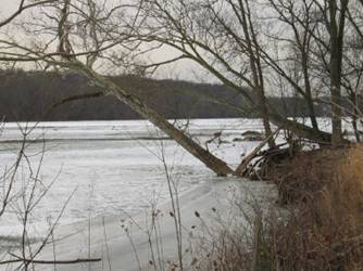
During the drought of 1999 you could see why. The rocks normally hidden underwater revealed
almost a reef of nooks, pockets and other places for fish to hide. The water was low enough when measuring these
routes in 1999, that you could almost rock hop your way across the river and
stay dry. In the cold winter of 2004,
ice floes hid it all. Ignore the side
trails that climb away from the water until you reach the Visitor Center (see
below) in Riverbend Park. Water and
restrooms are available there. At this
point you can shorten the route rounding the visitor center and heading across
the parking lot to the Center Trail. The
road-like natural surfaced Center Trail climbs a little to the Upland
Trail. Skipping this, go further another
three quarters of a mile along the river.
The PHT is over loose sand at one point but this ends soon. The Paw Paw Passage Trail begins your route
back. Identify it by a gravel road with
a blue blaze that splits off to the left, away from the river. It passes next to Black Pond in the
woods. Eventually get to Jeffery Road
and take the Center Trail to the Upland Trail.
After having been warmed-up on the flats, the Upland Trail is where you’ll
get your workout. It rolls and turns
through the woods. Some hills are a
little steep. The trail is well marked. Return on the PHT to Great Falls. Within Riverbend Park, mountain bikes are
allowed on the PHT, the Center Trail, and the Upland Trail. Probably because of the rocks near the
aqueduct dam, the National Park Service asks people not to ride bicycles on the
PHT inside Great Falls National Park.
Nearby and Connecting Zones
What to do Afterward
Food and Drink
Indigo At Great Falls - 703 759-4650
Old Brogue Irish Pub - 703 759-3309
Kabob Place - 703 757-7788
Romantica Deli & Pizzaria - 703 757-1791
Entertainment and Edification
Great Falls National Park - 703 285-2965
Riverbend Park Nature Center - 703 759-9018
Great Falls Grange & Old Schoolhouse - assembly hall
& one room school house - 703 938-8835
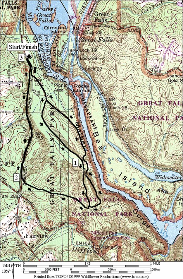
Old Carriage Road
Distance: 3.0, 1.8 or 2.8 miles
Rating: II, I, or II; bluestone, gravel or
dir trails; shady; one hill on the longest route
3.0
Mile Route
L 0.0 from
the parking lot on bluestone trail along Old Dominion Dr
L 0.1 Old
Carriage Rd (unmarked)
BL 0.25 at
trail X; follow signs to restroom
0.35 trail
X and restrooms
BR 0.4 to
stay on Old Carriage Rd; Matildaville Trail on L (no bikes)
0.55 Swamp
Trail on R
0.85 Swamp
Trail on R
<*
1.0 Matildaville
Trail on L (no bikes)
<**
1.35 Matildaville
Trail on L (no bikes)
R 1.35 Ridge
Trail (unmarked)
1.5 trail
X on L
1.6 trail
X on R to Carriage Trail (no bikes)
R 2.0 Old
Dominion Dr (! unmarked and no shoulder)
2.85 entrance
gatehouse
R 3.0 xwalk
at Visitor Center parking

*1.8
Mile Route
L 0.85 Matildaville
Trail; quarry is L/R (pickup cues at mile 2.25 on 2.8 mile route)

**2.8
Mile Route
L 1.35 Matildaville
Trail
1.6 trail
X on R to River Trail
L 1.7 at
T near canal after small wooden bridge over stream
R 1.8 trail
X after quarry; Carriage Rd on L
>*
2.25 gravel
road on R merges; Matildaville ruins
2.4 Carriage
Rd at restrooms; follow wide path toward Old Dominion Rd
BR 2.7 trail
along Old Dominion Rd
R 2.8 Visitor
Center parking
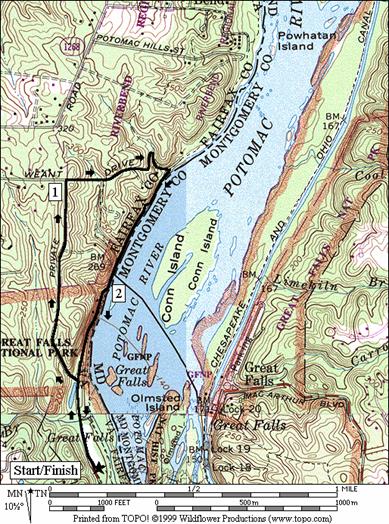
Weant
Drive
Distance: 2.65 miles
Rating: II; shady gravel roads and dirt trails;
parts are rocky and there is one big hill
R 0.0 from
parking lot ; Old Dominion Dr
0.15 Mine
Run Trail on L
0.3 follow
road up the hill past the gate; last parking lot is on R
0.5 Mine
Run Trail on L
0.65 River
Bend Trail on L
0.8 gravel
trail on R
0.95 trail
on R under telephone lines
R 1.05 Weant
Dr; pass gates (blue blazes)
1.2 trail
X on L; private drive on R
1.3 Upland
Trail
1.4 trail
X on L at switchback
R 1.5 Potomac
Heritage Trail (PHT); river
1.7 Upland
Trail on R
1.95 aqueduct
dam; rocks (!); GF Nat Park
2.0 trail
becomes rough gravel
2.1 trail
X on L goes along river
R/L 2.35 Old Dominion Dr
2.5 Mine
Run Trail on R
L 2.65 into
Visitor Center parking at xwalk
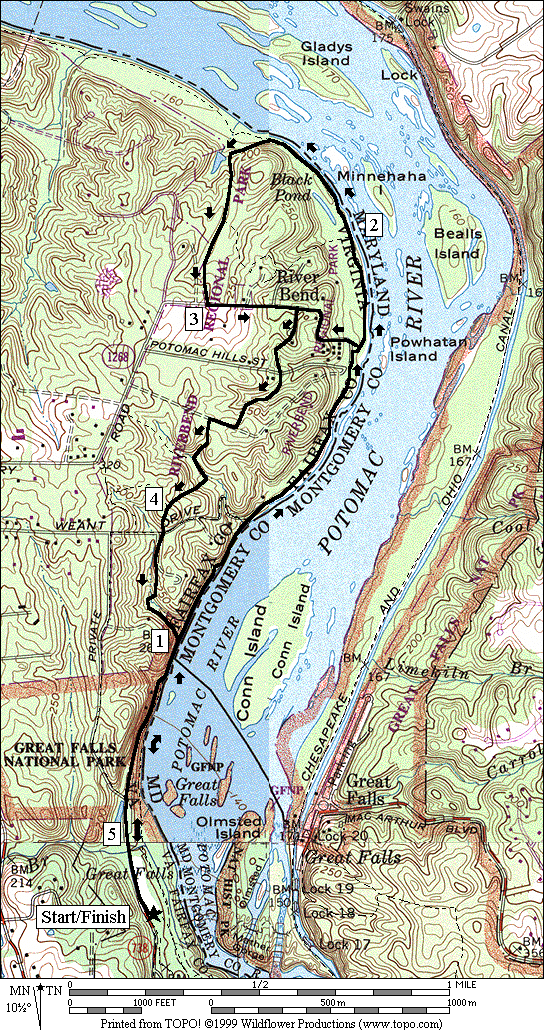
Riverbend
Distance: 5.2 or 3.95 miles
Rating: V, or IV; dirt trails w/rocky and
sandy spots; hills in the woods when returning
5.2
Mile Route
R 0.0 from
the parking lot onto Old Dominion Dr
0.15 Mine
Run Trail on L
R/L 0.3 last
parking on R; toward river on gravel road; becomes Potomac Heritage Trail (PHT)
0.55 trail
X on R
0.75 aqueduct
dam; rough rocks (!)
1.0 Upland
Trail (UT) on L (for return)
1.15 Weant
Dr on L (unmarked; gravel)
R/L 1.65 R at
Potomac Hills St; L on paved trail to Visitor Center
<*
BR 1.7 pass
the center then bear R to stay on the PHT; trail is sandy
1.8 trail
X on L
1.9 trail
X on L
2.05 trail
X on L to Nature Center
R 2.3 on
wooden bridge to stay on PHT at trail X
BL 2.45 Paw
Paw Trail; gravel road; blue blaze
2.55 trail
X on R at Black Pond
2.65 trail
X on L
S 2.75 trail
X on L to creek & Nature Center
L 3.0 Jeffery
Rd (unmarked)
S 3.15 Center
Trail is S as road turns L
R 3.25 Upland
Trail (UT)
>*
3.3 trail
X on L to Visitor Center
3.4 Potomac
Hills St (unmarked)
3.6 fire
road
3.7 at
T to stay on UT
L 3.75 at
trail X on L to stay on UT
3.8 trail
X on L
L 3.85 at
T after bridge over stream; UT
R 3.9 trail
X on R; to stay on UT
L 4.0 at
T at top of hill to stay on UT
CR 4.1 Weant
Dr; to stay on UT
L 4.15 at
T to stay on UT
R 4.25 at
T at river; PHT
4.5 aqueduct
dam; rocks (!); Great Falls National Park
4.65 trail
X on L follows river
R/L 4.9 Old
Dominion Rd from parking
5.05 Mine
Run Trail on R
L 5.2 Visitor
Parking at xwalk
*3.95
Mile Route
S 1.7 to
Visitor Center parking on paved trail; leave the riverside
1.75 across
parking at xwalk & go up the stairs to the Center Trail head (unmarked)
1.8 trail
bears R; trail X on L
L 1.95 Upland
Trail (pickup cues at mile 3.3 on 5.2 mile route)