![]()
In the 1970's the trip from D.C. to
Like Columbia, Maryland, another established planned
community, Reston has many trails and many good athletes. The runners, triathletes
and cyclists all place well in the Washington area=s
competitive events. Which came first;
did the athletes flock to Reston or did they get better because of the
trails? Two major trails and many other
nice ones can be easily reached from Reston.
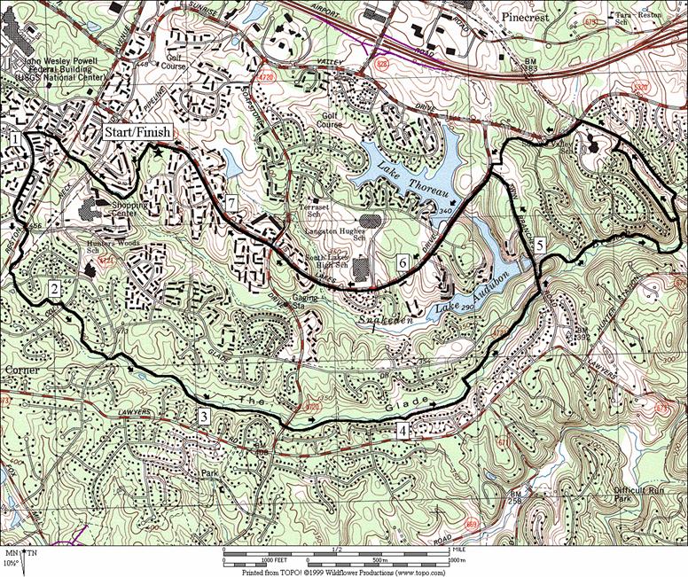
About four miles of the 44.6 mile long
Getting There
From the Capital Beltway
Take Exit 12, for the Washington Dulles Access and Toll Road, Rte. 267, west. When getting on to the expressway, stay to the (right) outer lanes. The inner lanes are only for access to Washington Dulles International Airport. Exit after 7 miles at Wiehle Ave, Rte. 828. At the stoplight on the exit ramp, turn left, crossing over Rte. 267. At a T-intersection with Sunset Valley Dr. turn right. At the next stoplight less than half a mile later, turn left onto Soapstone Dr. Turn right at the next stoplight after 0.9 miles, onto South Lakes Dr. Turn left into South Lakes Drive Park and park. Start from the parking lot where the paved trail coming from in-between the ball fields, hits the parking lot.
Area Routes
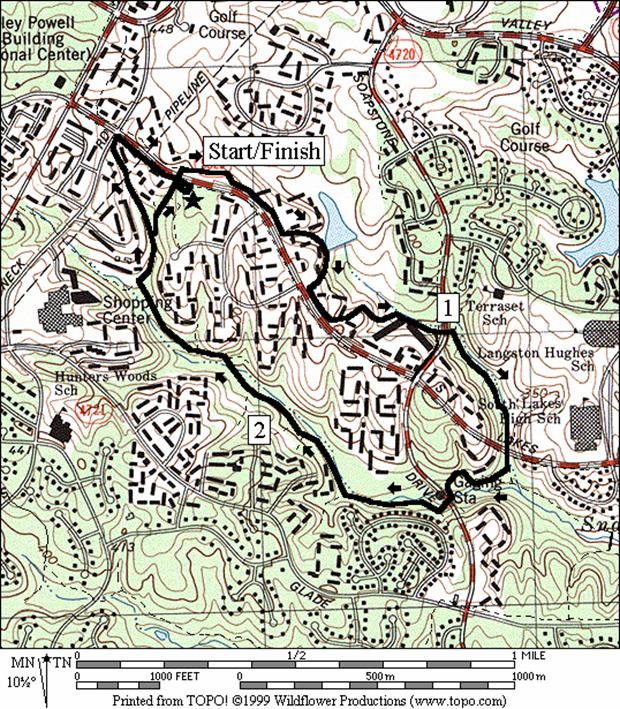
Snakeden (2.95 or 3.2 miles, II)
The hardest part of this easy loop, on paved trails through the woods, is getting familiar with the many turns. Some orienteering skill will help but really what you need to remember is how to follow a stream. Initially, take a trail through the tunnel under South Lakes Dr. After going along a golf course and passing by some town homes, go through the tunnel under Soapstone Dr. Follow the course of the stream downhill, going through some turns, and come to a second tunnel that crosses under South Lakes Dr. again. At the triangular intersection, turn right, now heading upstream along the Snakeden Branch (though there are probably some snakes here, you=re not very likely to see them). Follow the trail, leaving the woods briefly to pass a convenience store, into another tunnel under Soapstone Dr. again. Several paved side trails can be confusing but if you stay in the stream valley, eventually you will come to a T-intersection before the next tunnel. This time turn away from it and the creek climbing up toward the park. The optional extension goes to Colt=s Neck Rd. and requires a short segment on the grassy shoulder of South Lakes Dr. to get back. Getting a little confused on this route the first time around can be expected, especially while coming back upstream. Many people use the trails however and will probably give you assistance if you ask.
The Glade (7.45, 9.05 or 9.1 miles, VII, IX or IX)
The nicest paved trail in Reston is the one going through
The Glade, a stream valley park. Unlike
the Snakeden Branches which empty into Lake Thoreau
and Lake Audubon, The Glade has not been dammed. Long stretches of easy-to-follow trail are
characterized by light filtering through the tree canopies in a modest
valley. The Glade is cool in the
summertime, and protected from winds in Winter. To get there from South Lakes Drive Park, use
the trails along the Snakeden Branch to cross under
Reston Ave. Pass through a very short section in one of the rare less
prosperous Reston neighborhoods then use the sidewalk to return to Reston Pkwy.
on Glade Dr.
The feature trail can be followed from Reston Pkwy. to
the Twin Branches Rd. (a distance of 3.4 miles) with only a few easy road
crossings to break it up. Just follows
the creek downhill. Just before the
trail ends, it passes around a marsh area.
Begin the return on the sidewalk of Twin Branches Rd. You=ll pass Lake Audubon.
Though there is a visible trail at the shore of this lake, it does not
go all the way around. After
To extend the loop, cross over at Twin Branches Rd. to continue following the creek. The first drop down a gravel road after crossing the Twin Branches, is a little steep. Though it flattens for a while, some rocky and more hilly sections must be traversed before emerging at the W&OD Trail. If you like a trail that requires a little fancy footwork, you=ll like the hilly part of this trail. The longest options follows a less than half mile long trail along a buried sewer line that gradually climbs, and keeps you in the woods a little longer before coming to the W&OD Trail. The W&OD Trail takes you to Sunrise Valley Dr., where you can follow a paved trail back up to Twin Branches and South Lakes Dr.
In Fox Mill District park you=ll find some nice unpaved trails in the woods. They are not marked and there are some turns
to make however they aren=t
too hard to follow. Getting
there from
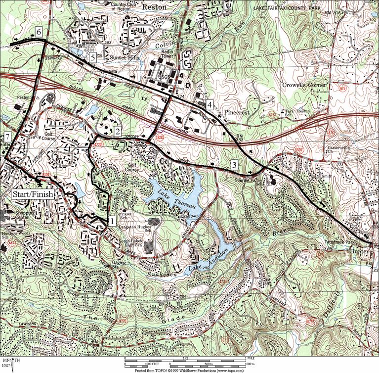
Sunrise/Sunset (7.5, 5.9 or 9.75 miles, VII, V or X)
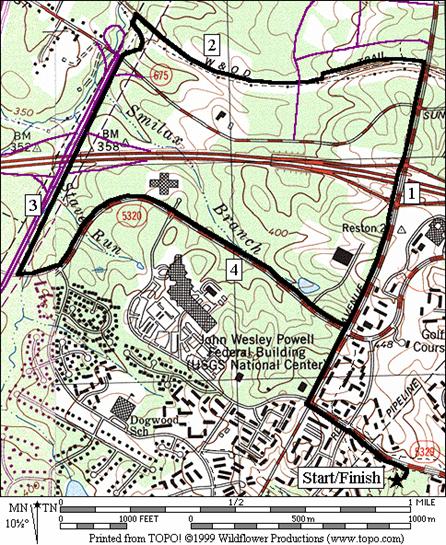
Reston is chock-full of trails. This route takes advantage of several of them with ways to extend or shorten your trip. First take trails down to Soapstone Dr. Turn left, still on trails, going uphill and passing some houses and more of the Reston National Golf Course. Sunrise Valley Drive is a four lane road with a paved trail right beside it that rolls but mostly descends to the W&OD Trail. Extend the trip by rolling up and down the W&OD Trail to Hunter=s Rd. on an out and back. Shorten the trip by cutting across on the path along Wiehle Avenue to the W&OD Trail and Sunset Hills Road. All options return on the W&OD Trail which parallels Sunset Hills Road. Though the name sounds forbidding, the railroad grade of W&OD through Reston smooths out the hills. A tunnel for the W&OD Trail was put in under Reston Avenue in the late 1990's. Pass under it before looping back past the Reston Town Center and return on the paved trail along Reston Avenue.
The west side of Reston was developed later than much of the rest. The outdoor Town Center, an outdoor mall and office park, gave those living in Reston and places west, a larger place to gather at night as well as work during the day. The four city-like blocks are people friendly with a fountain, a theater, restaurants, and a small covered outdoor skating rink where you can watch both good and bad skaters. The mall is surrounded by parking lots and has spurred other commercial developments. On this route, use asphalt trail mostly along Reston Avenue to pass by the town center. After the town center, go a little way west on the W&OD Trail. Next, take the trail along the Fairfax County Parkway, Rte. 7100. It joins where the W&OD Trail crosses the Smilex Branch; a stream that feeds into Sugarland Run in Herndon. You won=t see much of Smilex Branch however due to the parkway and the elevated railroad grade of the W&OD Trail. The parkway trail is not very pleasant. It is close to the road, sunny and hot from all the pavement in the summertime. There are some highway intersections on it to cross also. It is flat however. Stay on it only a short way to return on a gentle climb along Sunrise Valley Road. Pass several office parks along the way. Take Reston Avenue back to South Lakes Drive Park.
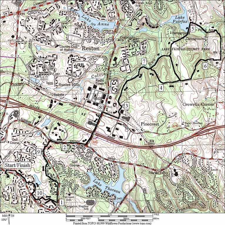
Lake Fairfax (10.65 or 8.6 miles, X or VIII)
Even before Reston was built, families had been coming to Lake Fairfax Park for decades. One of the things I looked forward to as a kid was riding the kiddie train. The pool was probably the most popular feature however. It=s been remade into an aquatic park. Peddling the sleek paddleboat (sleek in a sort of late 60's/early 70's way) around the lake was fun too. My dad would let me peddle but he liked it best when we parked it under the shade of the overhanging trees. I liked to keep moving. As it turned out the park had plenty more to explore. Today there are campgrounds, picnic areas, ballfields, and a nature and horse trail.
Getting to the park, follow the paved trails along South
Lakes Dr., Soapstone Dr., Sunrise Valley Dr., and Wiehle
Ave. to get to the W&OD Trail. The
hills are rolling but none are steep nor very
long. After less than an quarter mile
along the W&OD Trail turn left on
Nearby and Connecting Zones
Difficult Run
What to do Afterward
Food and Drink
Pizzeria
Uno - in the
HomeGrown Markets - Saturdays
Entertainment
and Edification
Frying
Wolf Trap Barns - indoor music and performance arts - 703 938-3405
R 0.0 when facing the park; from the parking lot
R 0.05 at
T; toward tunnel under
R 0.1 at
T; after tunnel under
0.35 cross road; trail moves away from Rd
0.45 pond on L
0.55 trail X on L; S toward road
L 0.7 on
trail on L before the
R 1.0 trail X after tunnel under Soapstone Dr; go downhill
BR 1.25 at trail X (triangle); school to L
BR 1.35 after
tunnel under
1.4 trail on L merges (triangle)
1.5 trail bears L; convenience store on R
R 1.55 trail X on R goes under tunnel; now going upstream along Snakeden Br
R 1.6 at T; houses are S
1.75 trail X L & R
BR 1.85 trail splits up different valleys
2.0 trail X on L
2.05 trail X on L
2.2 trail
X on L to
L 2.3 at T; trail X
L 2.4 at split in trail
2.45 trail X on L
R 2.6 at
T; L is to another T intersection & tunnel under
L 2.65 at trail X; S is to houses; L over wooden bridge
<*
R 2.75 multiple trail X; go toward park on R
2.8 trail X on R to park
R 2.9 trail X on R to parking
2.95 trail X on R at parking
![]()
*
S 2.75 multiple trail X; park is to R
R 3.0 onto
R 3.2 into S Lakes Dr Park parking lot
Snakeden
|
|
Distance: 7.45, 9.05 or 9.1 miles
Rating: VII, IX or IX; paved trails; some roads; hills and unpaved trail on longer route
R 0.0 from
parking lot when facing the field
L 0.05 at
T; downhill
L 0.15 at
multi trail X (unmarked); go downhill
BR 0.25 trail
X; go downhill
0.3 trail
X on L along Snakeden Branch
R 0.35 trail
X (triangle)
R 0.55 at
T to tunnel under Colt=s
Neck Dr; shopping is to the L
0.7 tunnel
under
0.75 trail
X on L after tunnel
BL 0.9 at
parking after basketball court
L
L
CR 1.45 at
BL 1.6 at
parking;
1.8 parking
1.85 trail
X on R
2.1 Colt=s
L 2.35 at
trail X; go downhill
L 2.45 at
T after crossing
R 2.8 trail
X on R toward
3.35 trail
X on L to
4.0 trail
X L & R to Glade & Lawyers Rd
L 4.3 trail
X on L to wooden bridge
L 4.9 at
T; go up Twin Branches Rd
<*
5.05
L 5.5 South
Lakes Dr; use grassy shoulder
>*
6.25
BL 7.4 on
trail into
7.45 trail X on L goes in-between fields
![]() *
*
CR 4.95 Glade
Rd on L; gravel road on R goes down steep hill
BL 5.16 at
gravel road to wood bridge over creek
5.35 single
track at dry dam; TR X L & R; up
5.55 trail
X on R after rocky &
rough trail
L 5.7 at
T before the creek
L 5.8 at
T after bridge over creek
<**
5.9 trail
X on L
L 6.0 W&OD
Trail
6.35 paved
trail on L to
>**
L 6.55 Sunrise
Valley Dr (follow paved trail)
6.75 cross
R/L 7.0 trail
X on R; L before tunnel to shops
7.1 Twin
![]()
**
L 5.9 trail
X on L to wooden bridge
R 6.35 sharp
R onto paved trail
L 6.4 W&OD
(next cues at mile 6.55 on 9.05 mile route)
The
Glade
Distance: 8.7 miles
Rating: VIII; paved and unpaved trails through the woods; shady with rolling hills
R 0.0 when
facing the park; from the parking lot
R 0.05 at
T; toward tunnel under
R 0.1 at
T; after tunnel under
0.35 cross
road; trail moves away from Rd
0.45 pond on L
0.55 trail
X on L; S toward road
L 0.7 on
trail on L before the
R 1.0 trail
X after tunnel under
BR 1.25 at
trail X (triangle)(downhill); school to L
BL 1.35 after
tunnel under
1.4 trail on R merges (triangle)
R 1.65 trail
X on R;
R 1.7 at
T; after bridge over Snakden Branch; up
R 1.95 at
T along
2.0
L 2.25 trail
X on L crosses
L 2.5 at
T; trail X; The Glade
CR 2.6 Soapstone
Dr; uphill
CR
3.25 trail
X L & R (dirt); L is return route
L
L 3.7 Riders
La
L
4.05 paved
trail head at end of road; Fox Mill Prk
L 4.15 at
basketball ct to go behind school on walk
BL 4.3 at
parking; at end of lot L again into woods on unmarked dirt trail that passes
graveyard
R 4.4 at
T before stream; follow trail downhill
L/R 4.55 at T;
continue downhill across bridge
L 4.65 at
bottom of hill before stream joins Difficult Run; up short steep rocky hill
BR 4.8 at
trail X to cross gully
4.85 trail
X on R to
5.0 trail
X on L
5.05 trail
X on R
5.3 trail
X on R
5.35 trail
X on R before gully
R 5.5 Foxclove Rd; unpaved trail continues to R/L
CL
L 6.1 at
T; The Glade; cross Soapstone Dr
R 6.2 trail
X on R; uphill
CR
6.7
L 6.8 trail
X on L; downhill
L 7.0 trail
X on L;
L 7.05 at
T; trail X
R 7.3 trail
X (triangle)
7.35 trail merges; go to tunnel under
BL 7.5 trail
X (triangle w/sewer in middle)
L 7.7 into
tunnel under
CR 8.0 Double
Eagle Ct to follow paved trail
8.15 trail
X on R
8.25 pond on R
BR 8.35 at
road X to follow trail
L 8.65 trail
X on L to tunnel under
L 8.7 trail
X on L
8.7 parking
at S Lakes Drive Park; trail on R
Fox Mill
|
|
Distance: 7.5, 5.9 or 9.75 miles
Rating: VII, V or X; paved sunny trails; rolling hills
R 0.0 facing the park; from the parking lot
R 0.05 at
T; toward tunnel under
R 0.1 at
T; after tunnel under
0.35 cross road; trail moves away from Rd
0.45 pond on L
0.55 trail X on L; S toward road
L 0.7 on
trail on L before the
L 1.0 trail X before tunnel under Soapstone Dr; go uphill
1.3
L 1.6 sidewalk
on
XS 1.75 at xwalk for golf course
CR
<*
3.1
<**
L 3.3 W&OD Trail
>**
3.6 end
underpass of
3.8 after xing
4.1
>*
4.95 Salliemae Dr underpass
5.4 underpass
R 5.75 trail
X on R; toward
6.0 trail
X on L to
R 6.05 trail
at
6.2
6.4 begin
overpass Rte 267;
6.85
CL
7.3 Colts Neck Rd; use grassy shoulder
R 7.5 into
![]()
*
L
2.4 begin
Rte 267 overpass;
CL 2.7 Sunset
Hills Dr; onto W&OD Trail (next cue at mile
5.0 on 7.5 mile route)
![]()
**
R 3.3 W&OD Trail; cross Sunrise Vall Dr
3.5 trail
X on R to
3.85 trail
X L & R after Mile Marker 15.5; R is to
U
4.95 trail
X L & R before Mile Marker 15.5; L is to
5.3 trail
X on L to
5.55 after xing
Sunrise/Sunset
Distance: 4.95 miles
Rating: IV; paved sunny trails; long easy grades
L 0.0 from
the park onto the shoulder of
0.2 Colts Neck Rd; trail X on L
CR 0.35 Reston Pkwy; asphalt trail
1.05 begin overpass of Rte 267; toll road
1.25
1.4 overpass W&OD Trail
L 1.45 trail X on L toward town center
1.5 trail X on R to town center
R 1.75 at T; W&OD Trail
1.8 overpass
L
2.5 begin
2.8 begin overpass of Rte 267; toll road
L 3.2 Sunrise Valley Dr; asphalt trail
R 4.35 Reston Pkwy; asphalt trail
CL 4.6 South Lakes Dr; use shoulder
4.75 Colts Neck Rd; trail X on R
R 4.95 into
|
|
Distance: 10.65 or 8.6 miles
Rating: X or VIII; paved and unpaved trails; some steep hills in the park; shady in the park
R 0.0 when facing the park; from the parking lot
R 0.05 at
T; toward tunnel under
R 0.1 at
T; after tunnel under
0.35 cross road; trail moves away from the road
L 0.7 on
trail on L before the
L 1.0 trail X before tunnel under Soapstone Dr; up
L 1.6 sidewalk
on
XS 1.75 at xwalk for golf course
CR
L
CR
CL
S 2.95 Rails to River Trail (RRT) (trail head is dirt and unmarked at the end of the court)
3.0 cross the parking area to the dirt trail
3.35 trail on L to Weihle Ave/Sunset Hills
3.65 trail X on L
BR 3.75 uphill after crossing a small creek; the Nature Trail joins from the L
L 4.2 L to stay on Nature Trail and leave RRT; top of a hill; edge of a field; white & red blazes
<*
R 4.55 gravel road at campground; C-34
4.6 gravel road X on L; water/restrooms
4.9 through the gate closing the road to the lake
R 5.0 after xing the dam, across grass & to road going down to the picnic area
L 5.25 onto gravel rd after xing Colvin Run (creek)
BR 5.3 at split in the road; go toward the pavilion
R 5.4 gravel road is the RRT; up steep hill
R 5.8 cross the field at the hilltop; R at the fence
5.85 trail leaves the field; down toward the creek
6.0 trail merges on R before xing creek
6.35 enter soccer fields; follow horse trail signs
BL 6.45 trail X upon entering woods; Nature Trail
BL 6.9 cross the creek; Nature Trail goes R
>*
7.0 trail X on R
7.3 trail
X on R to
7.65 cross parking lot to continue dirt trail
7.75 dirt
trail ends;
R 7.8 W&OD Trail
CL 8.0 Wiehle Ave; cross
R
L
XS 8.9 at golf cart crosswalk
R 9.05 trail X on R; paved
R 9.65 trail X; go uphill; tunnel on L goes down
CR 9.95 Double Eagle Ct to follow paved trail
BR 10.3 at road X to follow trail
L 10.6 trail
X on L to tunnel under
L 10.6 trail X on L
10.65 parking at S Lakes Drive Park; trail on R
![]()
*
R/L 4.55 onto gravel rd at camp C-34; downhill
L 4.6 Nature Trail on L; red blazes
R 4.9 trail X; RRT joins from L; cross the creek; (next cue at mile 7.0 on 10.65 mile route)
Lake