Jackson Miles Abbott Wetlands Refuge/Fort Belvoir
Over the course of millions of years the Potomac
River has gradually shifted its course and sediments have
filled-in its old river bed. The main
river once came through what is now Dogue Creek. Dogue Creek is in-between Mount
Vernon and Fort
Belvoir. Its mouth empties into the
Potomac three miles west of Mount
Vernon, near Woodlawn Plantation. The 1805 Woodlawn Plantation mansion was
given by George Washington to his nephew, Lawrence Lewis and his wife Eleanor
Custis Lewis, the grandaughter of Martha Washington. Dogue Creek and many of its tributaries are
now a wondrous wetland that is little visited.
Probably the best parts of it can be seen on the hiking trails and
boardwalk in nearby Huntley Meadows
Park (neither running nor cycling
is allowed on the boardwalk in Huntley
Meadows Park
but it=s very
much worth a visit). Huntley
Meadows Park
is one of the largest parks in Fairfax
County. The Jackson Miles Abott Wetlands Refuge
adjoins Huntley Meadows
Park to the southwest. The refuge was dedicated to its namesake, a
Lt. Colonel in the Army Corps of Engineers.
Fort Belvoir
is an active military base which besides employing many of the self-described ABest Damned Engineers in the World,@ is resource for many of the areas
military families. It has recreation
facilities such as golf, swimming pools, gyms, and what was at one-time
considered the largest commissary in country.
Getting There
From the Capital Beltway
Take exit 1 headed south on Richmond
Hwy., Rte. 1.
After approximately 7.5 miles, turn right on Old
Mill Rd. Go
only half a mile, then turn right at the T-intersection onto Pole
Rd (Meeres Rd.
is to the left at the T-intersection).
Turn left after only 0.2 miles into the Jackson Miles Abbott Wetlands
Refuge parking lot.
Area Routes
Plantation Road (2.15 or 2.8
miles, I or II)
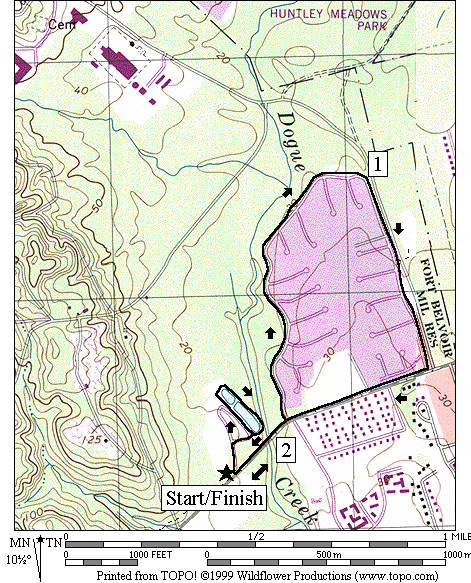
To see the wetlands without getting wet, follow the paved
trail along Pole Rd. across
Dogue Creek, then turn left. The sunny,
flat trail meanders in-between Plantation Road
and the wetlands, offering occasionally good views before returning to Pole
Rd. The
trail hardly gets any use so for that reason alone, makes it nice. As an option, add-on a very short loop (no
bikes) around a pond in the refuge that offers a closer look at the nearby
wetland. The pond is fished-in
regularly.
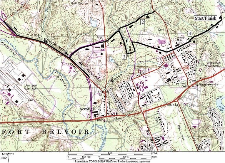
Fort Belvoir (7.25 miles, VII)
Following the trail west from the refuge, the way is
initially flat and shaded. The memory of
that will quickly fade as you climb a steep hill (110 ft. in less than
one-third a mile) up to Fort Belvoir. The trail becomes more of a sidewalk before
reaching the top. A second paved trail
is picked-up a little over half a mile ahead.
That trail drops down into the Mason Run stream valley before climbing
out again up another steep hill (70 ft. in less than one-quarter a mile). Using roads and sidewalks again, cross over Richmond
Highway, Rte. 1 to a bluestone surfaced running
trail. This trail is a 2.5 mile loop
that goes around a golf course and is accurately marked-off in quarter-mile
segments. It=s
mostly flat, partially shaded and very pleasant. Keep an eye-out for errant flying golf balls
however. After completing the loop,
return the way you came.
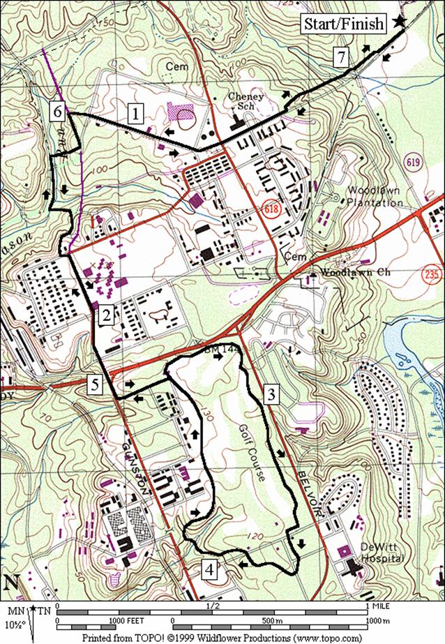
John Kingman Road (4.45, 6.8 or
5.75 miles, V, VII or VI)
This route goes out the same route as the Ft.
Belvoir route (above), to the Mason
Run stream valley. Once there, it turns
upstream (north), and then follows the trail to John
Kingman Road. Choosing to go right, gradually
climb along the road through trees on the paved trail. At Woodlawn Road,
turn around and return the way you came.
Were the trail to continue to the right or if there was a sufficient
shoulder along Woodlawn Road,
you could make a loop however, the half-mile segment to Meeres
Road is without either.
When first hitting John Kingman
Road you can choose to go left. The trail continues to be pleasant at first,
despite climbing a bit. After crossing Beulah
Road however, the zoning becomes industrial. The
chief reason for going this way is to get to the Fairfax County Parkway Trail
(FCPT). On the way, pass a large
complex on the left for the Defense Contract Audit Agency (think about the cost
of mil-spec hammers and toilets and you=ll
know why the facility is so big) and descend along the sunny road to the
FCPT. This part of the FCPT is not very
aesthetically pleasing despite essentially being in the Accotink Creek
watershed. The FCPT has long straight
segments, it=s too
close to the highway, and all the shade trees were cut down when making the
road. It=s
not as nice as the parts west of Route I-95.
What it may one-day be good for is bicycle commuting but today, it
hardly goes anywhere. Perhaps it will go
somewhere, when or if the parkway is completed.
For now use it for a run if you like barren stretches. Going west from John
Kingman Rd., the trail essentially stops at Telegraph
Road. Going
east, it stops at Backlick Road. Return the way you came for either
option.
Nearby and Connecting Zones
What to do Afterward
Food and Drink
Belvoir Grill - 703 780-8652
Paradise Restaurant - 703 781-8120
Entertainment and Edification
Woodlawn
Plantation - George and Martha Washington=s
respective nephew and niece=s
home - 703 780-4000
Frank Lloyd Wright - Pope-Leighy House - moved next to
Woodlawn - 703 780-3264
Mount Vernon -
George Washington=s home -
202 780-2000
Grist Mill
Park - off Mt.
Vernon Memorial Hwy., Rte. 235 near Route 1
Huntley Meadows
Nature Center
- (703) 768‑2525
Stone
Mansion and Stoneybrooke
Park - home of a friend of George
Washington built this home in
1777 - 703 938-8835
Plantation
Drive
Distance: 2.15 or 2.8 miles
Rating: I or II; flat, mostly paved trails along
wetlands; sunny
2.15
Mile Route
L 0.0 from
the refuge parking lot on the trail along Pole Rd
0.1 bridge
over Dogue Creek
BL 0.2 trail
bears left along Plantation Dr
1.25 trail
X on L
R 1.55 trail
along Pole Rd
1.95 Plantation
Dr on R and trail X on R
<*
R 2.15 refuge
parking

*2.8
Mile Route
R 2.15 through
refuge parking to trail head (portable outhouse)
L 2.3 trail
X at pond
L 2.65 trail
X on L after looping the pond
2.8 refuge
parking on Pole Rd
Fort Belvoir
Distance: 7.25 miles
Rating: VII; paved trails and roads, some
hills & a few good river views
R 0.0 from
the refuge parking lot on the paved trail along Pole
Rd
0.2 Old Mill Rd on
L; Pole Rd becomes Meeres
Rd (begin hill ahead)
0.7 Woodlawn Rd, Rte
618; use walk; Meeres becomes Gorgas Rd
1.15 Stonewall Jackson Dr
CL 1.2 Gunston Rd
R 1.35 paved
trail head on R (unmarked)
L 1.45 at
T at bottom of hill; Mason Run stream valley
L 1.8 Abbott
Rd (unmarked) at trail end & hilltop
CR 1.85 Gunston
Rd (use sidewalk)
2.2 bridge
over Richmond Hwy, Rte 1
L 2.3 1st Street
L 2.35 trail
X (bluestone/unmarked loop)
3.2 Mile
Mark 2
3.5 9th
Street
3.7 Mile
Mark 0.0/2.5 near tennis (portable outhouse)
3.85 9th
Street
4.1 bridge
over stream
4.75 Chapek Rd
L 4.85 1st Street
(loop is completed)
R 4.9 Gunston Rd
5.0 bridge
over Richmond Hwy, Rte 1
L 5.4 Abott Rd
R 5.45 trail
head on R; Mason Run stream valley
R 5.8 trail
X on R (unmarked)
L 5.9 Gunston Rd
CR 6.0 Gorgas
Rd; use sidewalk
6.1 Stonewall Jackson Dr
6.55 Woodlawn Rd, Rte
618; Gorgas Rd becomes Meeres
Rd
7.05 Old Mill Rd on R; Meeres
Rd becomes Pole Rd
L 7.25 into
refuge parking lot
Fort
Belvoir
John Kingman Road
Distance: 4.45, 6.8 or 5.75 miles
Rating: V, VII or VI; mostly paved trails,
some steep hills
4.45
Mile Route
R 0.0 from
the refuge parking lot on the paved trail along Pole
Rd
0.2 Old Mill Rd on
L; Pole Rd becomes Meeres
Rd (begin hill ahead)
0.7 Woodlawn Rd, Rte
618; use walk; Meeres becomes Gorgas Rd
1.15 Stonewall Jackson Dr
CL 1.2 Gunston Rd
R 1.35 paved
trail head on R (unmarked)
R 1.45 at
T at bottom of hill; Mason Run stream valley
<*
R 1.75 trail
X before John Kingman Rd
1.8 Gunston Rd
U 2.2 Woodlawn Rd
2.65 Gunston Rd
L 2.7 trail
X; Mason Run stream valley
>*
L 3.0 trail
X on L (unmarked)
L 3.1 Gunston Rd
CR 3.25 Gorgas
Rd; use sidewalk
3.3 Stonewall Jackson Dr
3.75 Woodlawn Rd, Rte
618; Gorgas Rd becomes Meeres
Rd
4.25 Old Mill Rd on R; Meeres
Rd becomes Pole Rd
L 4.45 into
refuge parking lot

*6.8
Mile Route
L 1.75 trail
X before John Kingman Rd
2.0 Beulah
St; use sidewalk
<**
R 2.5 Fairfax County Pkwy
Trail
U 3.4 Telegraph Rd
CL 4.3 John Kingman Rd
(use sidewalk)
>**
4.85 Beulah
St; paved trail head down hill
R 5.05 trail
X; Mason Run stream valley (pickup cues at mile 3.0 on 4.45 mile route)
**5.75
Mile Route
L 2.5 Fairfax County Pkwy
Trail
U 2.85 Backlick Rd
R 3.2 John Kingman Rd
(pickup cues at mile 4.85 on 6.8 mile route)
John
Kingman Road