Pohick
The
Not far from
Getting There
From the Capital Beltway
Take Rte. I-95 south for 6.7 miles to the Lorton exit. Turn left off the highway ramp onto
Area Routes
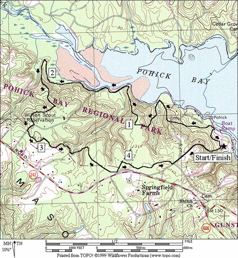
Watch your step on this collection of nature trails. The hills are steep, both climbing and descending. Your payoff comes from flatter sections of trail where you=ll cruise through the trees along the water=s edge. You=ll find Great Blue Heron=s gliding, Snowy Egret=s sitting in the trees, Red Wing Blackbirds hopping about and plenty of deer grazing.
Start on a blue blazed trail that climbs a little into the
woods then drops to the water=s
edge. The trail climbs through the woods
again and crosses a gravel road before again, returning to the water. The next climb is through a grassy power line
clearing. Stay in the clearing until you
see an obvious blue and red blazed trail on the right that climbs further. Turn right on the gravel service road at the
top of the hill that=s
blazed red; going straight is the Yellow and Blue Trail. This road descends a ridge with good views,
down to the water=s edge
again at a point where the bay takes on more of an appearance of being a
wetland. A bench to rest upon is
available at a very peaceful point that juts into the water. The road is flatter after this as it follows
the shore. Turn right on the Red Shore
Trail to make it last longer. A sharp
and obvious turn to the left goes up a ridge, past the golf course to a group
camping area. It=s
in the group camping area where you=ll
need to follow the blazes most closely to stay on the Red Trail. You=ll
go through some clearings, and make many turns and pass a few houses. Short segments on the Red Access Trail and
the Yellow Trail return you to
Nearby and Connecting Zones
Mason Neck
Jackson Miles Abbott Wetlands Refuge/Fort Belvoir
What to do Afterward
Food and Drink
Taste of
Tortillas Pacisico - 703 339-5564
Entertainment and Edification
Gunston Hall - 703 550-9220
Mason Neck National Wildlife Refuge - 703 690-1297
Distance: 4.8 miles
Rating: V; mostly dirt nature trails and gravel roads; steep hills; shady
0.0 from the parking lot; enter the woods at the Nature Trail sign (blue blazes)
L 0.25 at T; at water=s edge; R is to the boat ramp parking
0.35 cross the power lines again;
trail X on R
0.5 gravel driveway
0.65 cross the power lines again;
trail X on L
L 0.7 at water=s edge to stay on blue blazed trail
BR 0.75 in power lines; climb grassy hill in the power line clearing
R 0.9 horse trail (blue and red blaze)
R 1.0 gravel service road (red blaze); S is Yellow and Blue Trail
1.3 pointBgood views; bench
1.4 Red Cutback Trail on L
R 1.55 Red Shore Trail
L 2.15 sharp left on ridge; horse trail (red blazes)
2.5 golf course visible on R
R 2.55 horse trail on R (red blaze)
R/L 2.75 service road (follow red blaze)
R 2.8 gravel service road
L 2.85 Red Trail on L (red blaze)
R 3.05 campground road
R 3.1 Red Trail on R
L/R 3.2 bear L at trail X to stay on Red Trail; R at next where S is for horse trail
BL 3.35 at bottom of hill to stay on Red Trail at trail X
R 3.4 at trail X and cross stream; the trail is closed S ahead
L 3.95 after
the crossing power line clearing onto service road;
R 3.95 Yellow Trail on R
4.05 Red Access Trail
L 4.35 Pohick Bay Dr; gatehouse on R
4.5 Orange Trail on L
BL 4.75 at split in road and L into parking
4.8 Nature Trail head at parking lot
Pohick