![]()
Lake Accotink Park
Lake Accotink is a large public lake in Northern Virginia that=s close-in to Washington. The only one of similar size that=s closer is the private Lake Barcroft. The unpaved trail around Lake Accotink connects to an elaborate yet relatively unknown trail system. Mountain bikers have discovered much of it along with the nearby Wakefield Park. They along with runners and walkers regularly go back and forth between the two parks. Lake Accotink Park has picnic areas, boat rentals, and refreshment stands. People fish near the dam and in the free flowing parts of Accotink Creek. It=s not unusual to sight wildlife such as waterfowl and deer. In 1999 however, people were surprised to find and later capture a 3 foot alligator, presumed to have been a pet that someone set free.
Getting There
From the Capital Beltway
Take Rte. I-95 south for 0.9 miles to Old Keene Mill Rd.,
Rte. 644, and head west. After 0.75
miles, turn right on Hanover Ave. Go 1.1
miles, then turn left at
Area Routes
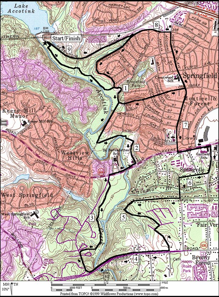
Lake Accotink (3.95, 7.95 or 5.15 miles, IV, VII or V)
The basic loop around Lake Accotink is 3.81 miles. Though much of the trail is flat, there are some hills to negotiate. The hardest is right at the beginning, just after crossing the creek below the dam. The nice thing about the hills is that they get you high enough for good views of the lake and the nearby wetlands. After the initial hills near the dam, the trail is on an abandoned railroad grade. The route is mostly surfaced with bluestone. There are short paved sections and a third of a mile on suburban sidewalks. After the sidewalks, there are stairs to go down. The lake trail rolls for the last mile-and-a-half back to the start. Mile markers are posted going both directions around the lake.
Two extensions use different portions of the Long Branch Trail. The short one requires crossing Braddock Rd. at a traffic light. This part of the Long Branch Trail is not the best part of that trail. It=s poorly maintained but passable. It returns back to the basic loop on the east side of Accotink Creek and Lake. The long extension follows the railroad grade all the way to Rolling Rd. After one-and-a half miles on sidewalks, it returns on a very pleasant part of the Long Branch Trail north of Braddock Rd.
A variant of the Lake Accotink Loop is to turn left off the lake loop trail to go up to the Carrleigh Parkway. Despite climbing the hill at the dam earlier, the paved trail to Carrleigh leaves the lake loop climbing steeply with switchbacks. On the way, it crosses one of the many dirt trails in the area used for mountain biking, hiking and running. It also crosses over the Southern Railroad. The way outside the park on the Carrleigh Parkway and Forrester Blvd. is slightly rolling. Cross over Rolling Road to use a paved trail along it before heading back into Lake Accotink Park. The way back in is not marked but not hard to find. It comes just after crossing the railroad tracks again. It=s paved at first but soon turns to dirt. The unpaved portion was previously a railroad grade. The gentle downhill grade continues approximately a mile-and-a-half almost uninterruptedBmost of the way back.
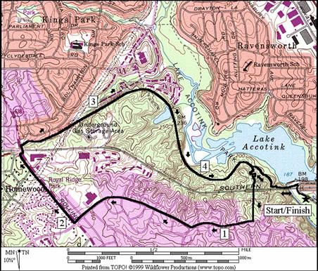
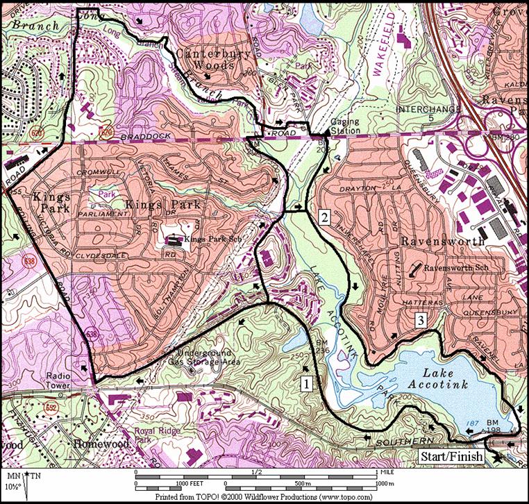
Springfield (9.15, 2.65 or 3.6 miles, IX, II, III)
Besides its suburban neighborhoods, Springfield is known for its shopping mall and the infamous mixing-bowlBthe Capital Beltway and I-95 South highway interchange. On this route, you=ll skip that mess and get as far south as the Springfield/Fairfax County Parkway and bike trail. The adventurous should enjoy the dirt trails along Accotink Creek south of the lake. They can be a little daunting to remember when looking at the number of turns on the que sheet and realizing that many are unmarked. Red blazes do mark a dirt main trail however, the blazes aren=t always prominent or everywhere that you=d hope they would be. There are several turns to take to stay on the main trail. If you try this route and continue on a generally downhill path paralleling the creek as you go out, you should find your way. Another discouraging factor of this route is that much of the trail is on a flood plain. In wetter months, it stays wet. Mountain bike cyclists use the trails as do people fishing or walking. After leaving the lake area however, you will likely encounter only few of them.
Two short options leave the woods and flood plain earlier to return through neighborhoods. After passing them, the route is under telephone lines on one segment, and along a flat pipeline for the next. After passing through Byron Avenue Park and crossing Old Keene Mill Rd., a partially paved and partially bluestone trail on the west side of Accotink Creek lets you climb to the Fairfax County Parkway Trail (FCPT). Use the FCPT to cross back to the east side of the creek and climb the long hill on the other side. Pass through some more neighborhoods, and a small paved trail back down to the Accotink Creek valley before going up a steep dirt scramble to Oriole Avenue; an awkward but short part of the route. The rest of the way is back through neighborhoods, on streets or sidewalks; roughly the same route described to drive in on.
Nearby and Connecting Zones
What to do Afterward
Food and Drink
Silver Diner - 703 924-1701
Austin Grill - 703-644-3111
Hard Times Café - 703 913-5600
Dairy Queen - 703 866-2253
HomeGrown Markets - Thursdays 9am-1pm, MayBOctober; Mason District Park - 703 642‑5173
Entertainment
and Edification
Lake Accotink Park - 703 569-3464
Wakefield RECenter - 703 321-7081
Patriot Center - 703 993-3000
Distance: 3.95, 7.95 or 5.15 miles
Rating: IV, VII or V; mostly bluestone trails; some short steep hills; shady
L 0.0 from
parking lot, head on the trail, under the RR tracks toward the dam
L 0.1 at
trail X to cross the creek; begin loop trail
0.15 bridge
over creek below the dam
0.45 paved
trail on L to
0.55 trail
X; blue blazed
1.15 trail
X on L before upper dam/marsh on L
1.4 Mile
Marker 1.5; trail X on L
<*
R 1.45 down
to the road; follow sign for Accotink Park Trail
1.5 trail
ends; use
BR 1.8 after
<**
R 1.9 over
wooden bridge to stay on loop; Long Branch Trail goes S (unmarked)
R 1.95 at
T; Lake Accotink Trail
>**
2.4 Mile
Marker 2.5
2.9 Mile
Marker 3
BR 3.1 at
trail X on L with blue blaze (goes to Hatteras La) to stay on loop trail
BL 3.2 at
trail X on R to stay on loop trail
R 3.75 around
the marina; (portable outhouse)
BL 3.9 at
RR underpass; loop trail goes S
3.95 parking
![]()
*
S 1.45 TR
X on R to road is lake loop trail
1.85 pass
through/around gate
R 2.25 Rolling
Rd (use sidewalk)
R
BL 3.45 onto
R
R 4.1 Long
Branch Trail (unmarked); near
4.65 TR
X on R at wooden bridge
S 5.15 cross
![]()
**
S 1.9 Long
Branch Trail (unmarked); wooden bridge on R
CR
L/R 2.3 L on
>*
R 2.45 go
between ball fields and parking lot in
R
L
L 2.7 after
crossing over Accotink Creek
L 2.75 Accotink
Creek Trail; go under
Lake Accotink
L 0.0 from parking lot head on the trail under the RR tracks and toward the dam
L 0.1 at trail X to cross the creek; begin loop trail
0.15 bridge over creek below the dam
L 0.45 paved trail on L to Carrleigh Pkwy
0.6 trail X; dirt
0.65 bridge over RR
R 0.8 Carrleigh Pkwy
R 1.2 Forrester Blvd
CR 1.95 Rolling Rd; use paved trail
XS 2.45 Burke Rd on L, TL
R 2.5 at 5701 Rolling Rd; unmarked paved road immediately after the bridge over the RR
2.9 gate; pavement ends
3.2 trail X on R
S 3.3 trail
X on L to
3.6 trail X on R after dam and marsh on R
4.25 trail X; blue blazed
4.35 paved trail on R to Carrleigh Pkwy
4.6 bridge over creek below the dam
R 4.7 trail X on R goes under the RR bridge
4.8 parking
|
|
Distance: 9.15, 2.65, or 3.6 miles
Rating: IX, II or III; unpaved, paved trails, road sidewalks; rolling hills; two-thirds shady
9.15 Mile Route
R 0.0 on the trail while facing Lake Accotink
Access Rd from the parking lot
R 0.05 on the trail at the end of the parking lot
0.1_ trail head toward the creek in the lot corner
L 0.1 gravel trail parallel to creek with red blazes
R 0.45 after wooden bridge to stay on blazed trail
R 0.6 after wooden bridge to stay on blazed trail
0.8 trail X on R as trail bears L
<*
0.95 trail X on L at top of bluff (unmarked)
1.0 cross stream on rocks; Brookfield Park is L
<**
1.15 trail X on L to Essex Rd (unmarked)
S 1.25 cross creek on stones (!); trail X on R fire hydrant on other side of creek; continue up the hill under telephone lines
1.55 trail X on L to Mendotta Pl (unmarked)
L 1.6 trail X on L (unmarked) near bottom of hill; along buried pipeline; creek is far to the R
1.8 trail
on L to
L/R 1.85 BL at stream; then cross and bear R
1.9 Byron Ave Park; S toward road around field
R 1.95 gravel road; becomes Byron Ave
R 2.15 paved trail along Old Keene Mill Rd
L 2.4 Tiverton Dr/Hunter Village Dr (TL)
L 2.45 trail head (unpaved & unmarked)
3.15 trail X on R (paved)
3.2 trail X on R (paved)
R 3.25 trail X on R at wood bridge; up steep hill
BL 3.35 Hunter Village Rd
L 3.45 Fairfax County Pkwy Trail (unmarked)
3.55 begin bridge over Accotink Creek
CL 4.3 Spring Village Dr
R/L 4.55 R on Hampton Creek/L at paved trail head
R 5.1 after paved trail ends; go up the steep hill
5.3 begin Oriole Ave at its end (unmarked)
L 5.7 Ridgeway Dr
R 5.9 Tanager St
L 6.15 Spring St (use sidewalk)
CL 6.4 Old Keene Mill Rd (TL)
CR 6.75 Hanover Ave
7.34 Essex Ave
>**
L 7.85 Highland St
R 8.2 paved trail head on R into Accotink Park
>*
8.45 paved trail ends; Lake Accotink Access Rd
L 9.15 parking lot
![]()
*2.65 Mile Route
L 0.95 trail X on L at top of bluff (unmarked)
1.0 trail ends; begin Highland St at Loretto St
1.2 trail X on L (unpaved/unmarked)
L 1.7 paved trail on L into Accotink Park (pickup cues at mile 8.45 on 9.15 mile route)
![]()
**3.6 Mile Route
L 1.15 trail X on L to Essex Rd (unmarked)
1.2 trail
ends; begin
L 1.75 Hanover Ave at top of the hill (pickup cues at mile 7.85 on 9.15 mile route)
Springfield