Wakefield Park
One of the more popular public facilities in Fairfax
County is the Wakefield RECenter,
off of Braddock Rd. in Annandale. With swimming and diving pools, weight and
exercise rooms, racquetball, volleyball and wallyball courts, a photo lab and a
gymnasium, the place stays busy.
Outside, there are ballfields and picnic areas. It=s
also a very popular starting point for runners and mountain bikers. The Accotink Trail runs the north/south
length of the park. That trail is only a backbone for the maze of other dirt
trails that wind through the woods. Even
a mountain bike race course is included in the park. Leaving the park borders on the Accotink
Trail from the south, you can reach the nearby Lake
Accotink. Making a loop around the lake from the
starting point described below is only 5.18 miles (see the Lake
Accotink section of this guide for
a description of this route).
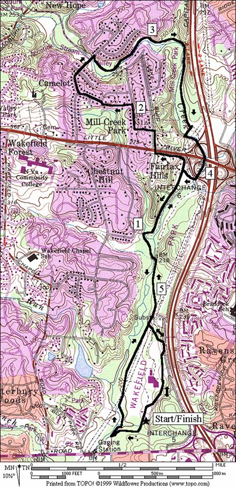
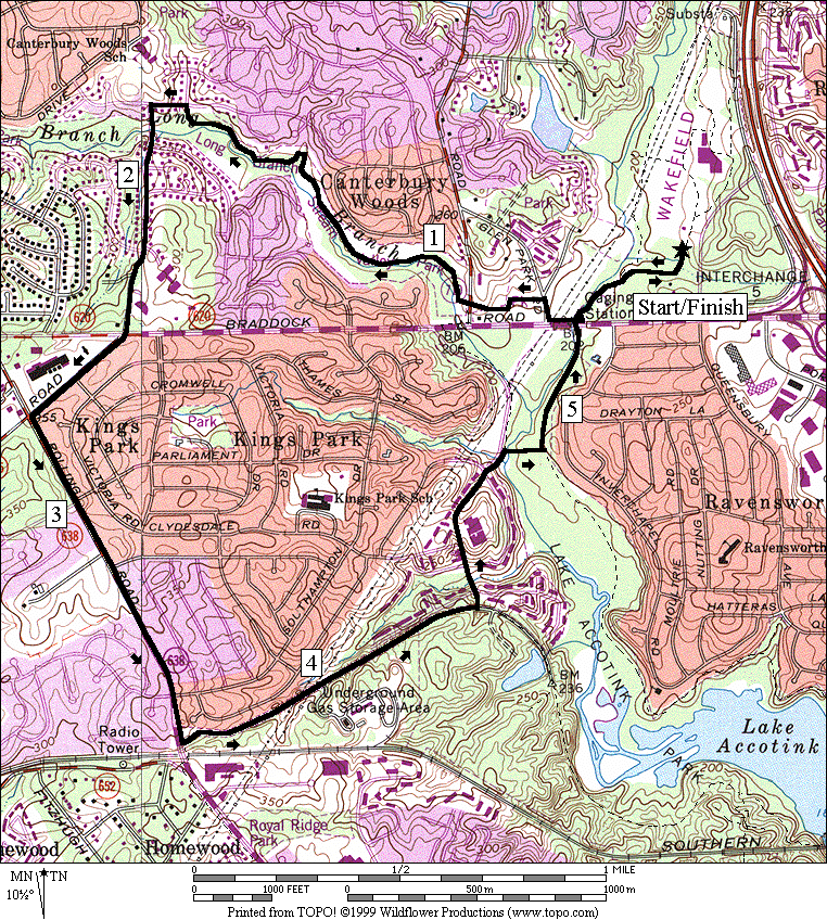
Getting There
From the Capital Beltway
Take Exit 5 for Braddock Rd.
headed west. Turn right after 0.35 miles
into the Wakefield Park
entrance. Park at the first lot on the
left. Routes start from the Accotink
Trail head, at the left corner of the lot.
Area Routes
Long Branch/Accotink (5.6
miles, V)
Part of the Accotink Trail system is the trail along one of
Accotink Creek=s
tributaries. The Long Branch Trail (don=t confused this with a trail by the
same name that=s part of
the Anacostia Trail system in Maryland
or other Long Branch creeks in Virginia) is a pleasant bluestone surfaced trail
south and west of Wakefield park. Mostly
flat, the less than 1.5 mile long wooded trail ends at Canterbury
Woods Elementary School. Continue on sidewalks, following suburban
neighborhoods roads across Braddock Rd.,
and then along Rolling Rd. Use an old railroad grade trail to get into Lake
Accotink Park
and the lake loop trail (see the Carrleigh route in the Lake
Accotink section of this guide for
a description of this segment). Use the
flat Accotink Creek Trail to return to Wakefield
Park.
Mill Creek Park (5.65 or 6.15
miles, V or VI)
Trails along the Accotink can be followed continuously over
14 miles from Arlington Boulevard,
Rte. 50 in the City of Fairfax, to
the Fairfax County Parkway Trail in Springfield. Very little of this is paved though major
segments, with different names, are maintained.
Going north from the parking lot, through Wakefield
Park, the way needs some
explanation in order to be followed. The
problem in Wakefield Park
is not in finding a trail; it=s
in finding the correct trail. So many
paths, some paved, some not, intersect and are unmarked so that it may take you
a second or third try to go through with confidence that you=re on the main route. To begin, when facing the field from the
parking lot, go up the sidewalk to the right.
The walk becomes a trail. At the
first turn bear right climbing slightly to go into the woods. Pass the recreation center on your left and
eventually get on the park road. Near
the pedestrian bridge that goes over the beltway, on your right, bear left
going into the woods again, downhill on a trail. Round the power substation on your right at
the bottom, then follow the road-like gravel trail through the flats. The longer option gets to the substation by
going the other direction on the Accotink Trail first, then taking a dirt trail
under the power lines.
Continuing north from the substation, cross a wooden bridge
on your left over Accotink Creek. Just
before you reach what appears to be the end of the trail at Mockingbird Dr.,
turn right to cross a small stream on a concrete wash Abridge@ to continue the trails. When this trail appears to end at the Accotink
Pkwy., just go on straight ahead. Americana
Park, a ballfield will appear on
your right. Trails continue through this
park, going along the creek and under the highways however that will be your
return route. For now, go straight,
climbing the steep hill on the road.
Continue on roads, carefully crossing Little River Turnpike, Rte.
236. After some modest rolling hills
through the neighborhood of Mill Creek
Park, you will drop back into the
Accotink Creek valley. The point where
you join the trail is the end of the Eakin Trail (see Eakin
Community Park). The Eakin Trail goes upstream through Eakin
Community Park. Instead, go downstream into Mill
Creek Park. The way is on an un-maintained dirt trail on
the northeast side of the Accotink. Just
before reaching the power lines, turn right and cross Accotink Creek on stones
(don=t attempt
this route if it has been raining recentlyBthe
water may be high and any way, the trail will be muddy). Turn left again, hopefully still dry, to
follow the creek under highway access ramps and Little River Turnpike. Emerge at Americana
Park, and return the way you came
on the Accotink Trail.
Nearby and Connecting Zones
Accotink Park
Eakin Community
Park
What to do Afterward
Food and Drink
Tiyaki Grill - 703-913-6300
picnic
Entertainment and Edification
Lake Accotink
Park - 703 569-3464
Wakefield
RECenter - 703 321-7081
Wakefield Chapel
- nondenominational, built in 1899 - 703 750-1598
Hidden Oaks Nature
Center - 703 941-1065
Long
Branch/Accotink
Distance: 5.6 miles
Rating: V;
bluestone trails and sidewalks; few hills; partly sunny
L 0.0 from
parking lot, on the Wakefield Accotink trail, head down to the wooden bridge in
the woods
0.25 trail
on R merges
BL 0.3 up
to Braddock Rd at the
utility bldg
R 0.35 Braddock Rd;
bridge over creek
R 0.45 Glen Park Rd
L 0.5 trail
between field and parking; Oak Hill
Park
L 0.6 at
T at end of field; follow trail L/R
CR 0.75 Wakefield
Chapel Rd; follow the unmarked bluestone trail along the creek
1.25 bridge
on L
L 1.8 Queen Elizabeth Blvd
L 1.85 Woodland Way
S 2.45 cross
Braddock Rd (!); becomes Burke Lake Rd
L 2.75 Rolling
Rd
3.5 Lake
Braddock Rd
L 3.6 unmarked
road on L into Accotink Park
at 5701 Rolling Rd;
before the bridge over the RR
4.0 gate;
pavement ends
4.3 trail
X on R
L 4.4 trail
X on L to Danbury Forrest Dr
for lake loop
4.45 trail
ends; use Danbury Forest Dr
BR 4.7 after
Lonsdale Dr on R; down
stairs (!) to the trail
R 4.8 over
the wooden bridge to stay on loop; Long Branch Trail goes S (unmarked)
L 4.9 at
T; Accotink Trail
5.25 underpass
Braddock Rd
5.3 trail
X on R to Braddock Rd
5.35 trail
X on L as trail goes R
5.6 parking
lot
Long
Branch/Accotink
Mill Creek Park
Distance: 5.65 or 6.15 miles
Rating: V or VI; dirt and bluestone trails
and suburban streets; shady with one major hill
5.65
Mile Route
<*
R 0.0 along
the parking lot on the sidewalk
BR 0.05 cross
the wooden bridge on the trail going up into the woods
0.1 park
road X
0.15 recreation
center on L
L 0.2 after
recreation center entrance road, L on the gravel road
BL 0.3 trail
on L going downhill in the woods; pedestrian bridge ramp on R goes over I-495
R 0.45 wide
gravel road-like trail; power substation
>*
L/R 0.85 wooden
bridge over Accotink Creek
0.9 trail
X on R (unmarked)
R 1.0 cross
the small tributary creek on concrete
BL 1.05 trail
X L & R (unmarked); follow pipeline
S 1.3 trail
ends; Accotink Pkwy at Pine
Ridge Rd
1.45 road
into Americana Park
on R (for return)
R 1.7 Pine
Ridge Dr; cross Little River Trkp;
Rte 236 (!)
L 1.8 Millcreek Dr
L 2.05 Woodland Ave
R/L 2.2 Hillcrest Rd/Brittany Dr
R 2.35 King Arthur Rd
R/L 2.6 trail
X on R after the bridge over Accotink Creek; L on trail at T; paved trail
becomes singletrack and follows creek downstream
BR 2.95 on
gravel; trail X on L (paved) goes uphill
3.2 cross
tributary stream
3.45 trail
X on R near a vertical vent pipe
R 3.7 trail
X on R before power line clearing; cross the creek on stones (!)
L 3.75 after
crossing; stay along creek; trail X on R goes along power lines
3.95 Little
River Trkp, Rte 236; 3 underpasses
R 4.1 to
parking and the road in American Park
L 4.2 Accotink Pkwy
S 4.35 trail
at end of the road; Pineridge Rd
on R
R 4.6 trail
X (unmarked)
L 4.65 at
T after crossing stream on concrete
4.7 trail
X on L
L/R 4.8 wooden
bridge over Accotink Creek
BL 5.2 at
substation; trail X on R along power lines
R 5.3 gravel
road; pedestrian ramp over I-495 is S
R 5.45 trail
on R toward recreation center parking entrance
5.5 recreation
center on R
5.55 park
road X
BL 5.6 after
wooden bridge toward parking
5.65 parking/Accotink
Trail head

*6.15
Mile Route
L 0.0 from
parking lot, on the Wakefield Accotink trail, head down toward the wooden
bridge in the woods
R 0.25 sharp
R on trail that merges on the R
L 0.35 to
cross the small tributary creek
L/R 0.5 at
the gully; merge w/power line trail
0.6 trail
X (unmarked)
BL 0.95 gravel
road at substation (pickup cues at mile 0.85 on 5.65 mile route)
Mill
Creek Park