South Run District Park
The wealth of trails in Fairfax
County really becomes apparent when
you start exploring the paths around South
Run District Park
and Burke Lake. Just about every high school cross country
runner in Fairfax County
is familiar with Burke Lake;
location of the District and Regional meets held annually in the fall. Others as well have been coming for decades
to the placid shores of Burke Lake
for running, walking and bicycling. South
Run District Park
is a little over a mile south of Burke
Lake. It has a relatively new sports facilities for
swimmers, ball players, and for field hockey players, there is an indoor field
house. By starting from South Run
District Park, you=ll escape
an entrance fee for out of county residents who go to Burke Lake Park, but not
likely escape the large numbers of people who come to both parks. Also nearby are many other lakes with trails
around them. Lake Mercer
can be accessed via the South Run trail and is south of the park. Lake
Huntsman Lake
is just across the Fairfax County Parkway
from the park. Using the Fairfax County Parkway Trail (FCPT), you can go toward
Fairfax City
and make loop to Lake Barton. All of these lakes are county
reservoirs. Going in the other direction
on the FCPT, you can connect to the Accotink Creek stream valley trail system
and loop back near Middle Run.
Getting There
From the Capital Beltway
Take Braddock Rd.,
Rte 620, west for 1.75 miles. Turn left
onto Burke Lake Rd. Turn left approximately 3.5 miles later onto
the Fairfax County Parkway,
Rte. 7100. Go just over 2 miles and turn
right into South Run
District Park. Proceed down the hill, passing fields and the
natatorium on the left. Park near the
trail head, behind the natatorium and near the field house.
Area Routes
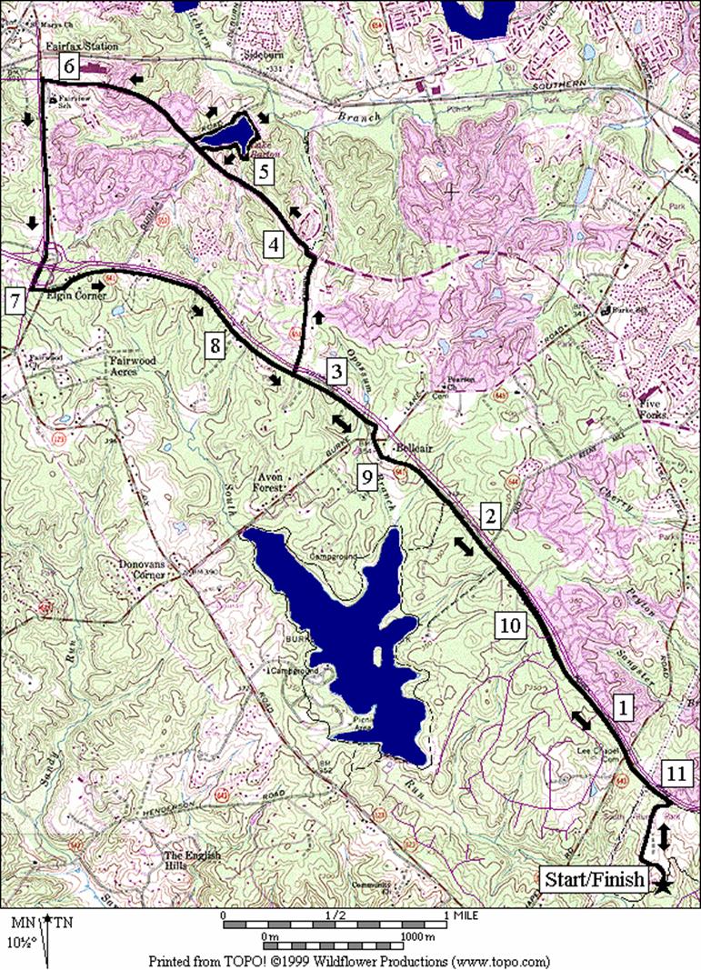
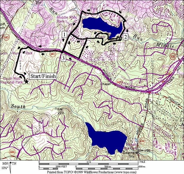
Burke Lake (7.35 miles, VI)
This very popular route is well worth the trip. A bluestone trail wanders around the fingers
of Burke Lake
under pine and oak trees. The flat loop
around the lake is marked-off in half-mile segments and the whole way around is
4.61 miles long. A fitness course also
is on the lake loop. To get there from South
Run District Park,
follow a paved trail upstream along South Run.
The trail reaches Burke Lake
after climbing a hill at the dam, in one of the few sunny parts of the
loop. Water and refreshments are
available in the park. Though several
trails branch off the lake loop, the way is easy to follow and you=re almost always within sight of the
cool blue waters.
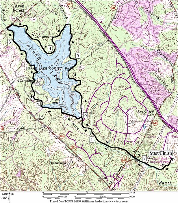
Burke Shores (5.25, 4.55, 3.5 or
1.5 miles, V, IV, III or I)
The FCPT parallels the trail along South Run toward Burke
Lake. Several trails connect the two and can be
used as alternate ways to get to Burke
Lake, or for shorter loops. From the parking area use sidewalks, gravel
trails and the park roadside to climb to the FCPT. The FCPT has a slight uphill grade as you
head in the direction of the City of Fairfax. It=s
not as nice as the trails along South Run or around Burke Lake but the trail is
far enough away from the parkway to still be enjoyable. Your first option to cut back is almost
immediately on your left, after the climb to the FCPT. It a loosely defined dirt trail through power
lines and is popular with mountain bicyclists.
It drops quickly just before reaching the trail along South Run. Skipping this, the next option is to pass
through South Run neighborhood streets.
That way is gradually downhill after turning off the FCPT, and reaches
the trail in the South Run valley, very near the Burke
Lake dam. The next option is to turn left using both a
gravel road and trail that drops significantly before reaching Burke
Lake near Mile Marker 3. The final option is similar, using another
unpaved road through the Burke Lake Wilderness Area. It reaches the lake near the northernmost
point; near where Opossum Branch enters the lake. Both the last two options are wooded quieter
parts of the park that most don=t
see. Use the Burke Lake Trail and/or the
South Run trail to get back to South Run
District Park.
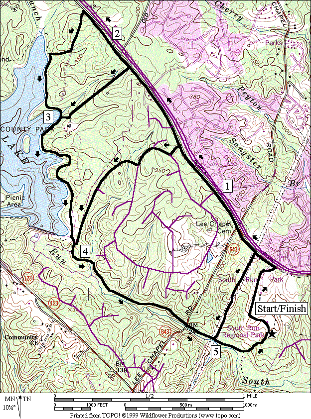
Lake Mercer (4.55 or 5.1 miles, IV
or V)
Burke Lake=s waters empty into South Run. A couple of miles downstream, a second dam
creates Lake Mercer. Lake
Mercer is smaller but rather
pretty. Going up and down the short
steep hills on the way to the lake I saw through the trees a Great Blue Heron
flying below me and over the wetlands.
The paved trail runs out before reaching the dam. A dirt trail, more paved trail and suburban
street sidewalks bring you to the dam. Crossing
the dam is awkward. Gates on both ends
block bicycle access. You must cross the
grassy (dry) spillway overrun for the dam then scamper up a small but steep
grassy hill onto the dam. After the dam,
a paved trail continues partway around the lake again before use of a dirt
trail on a dyke, and a gravel road are necessary. The route eventually leaves the wooded stream
valley getting back to South Run
District Park. Cutting through woods on small a dirt trail,
the route follows along the inside borders of the park on the grassy Spartan
Trail. The Spartan Trail loops the park
but is not included in this guide because many parts of it are too ambiguously
marked. It can be followed on this route
however to the trail head and parking lot behind the field house.
The longer option of this route climbs the hill on the
opposite side of South Run up to a paved trail along Silverbrook
Rd. In
getting there it passes through suburban streets. It does the same when returning to the main
route. The scenery is nicer on the
shorter option however.
Huntsman Lake (3.8 miles, III)
To get to Huntsman
Lake, climb up to the Fairfax
County Parkway Trail and go east only one third a mile. At the traffic light, cross over the parkway
and go down to the lake on a wide paved trail along Huntsman
Blvd. Don=t turn right again until you pass the
lake. Turn onto Golden
Ball Tavern Ct. where the trail ends. Though there=s
what seems to be a trail dropping to the lake shore almost immediately on your
right, that path ends abruptly. Golden Ball
Tavern Ct. is fairly quiet. Leave the road, turning right through a gate
on what seems to be a driveway dropping down to the lake. The driveway becomes a paved trail which
climbs back up to the dam. After
crossing the dam, the paved trail ends but you can follow a dirt trail a short
way through the woods to an intersection with another paved trail. Bearing left, a sort of outer loop trail goes
through the woods. Turning right sharply,
the inner loop trail stays closest to the lake; closer than anywhere else on
the route. Both options join together
again near a basketball court though you must make one unmarked turn when using
the outer loop. There are also several
other intersecting trails that may confuse you if you are not familiar with the
area. The paved trails end again after
the basketball courts at Dorothy Lane. By going left up the hill, you can continue
on an asphalt trail to the Fairfax County Parkway. If you want, go straight on Dorothy
Lane to avoid the hill for a little while more but
doing so only increases your eventual climb.
All route options listed add-up to the same distance.
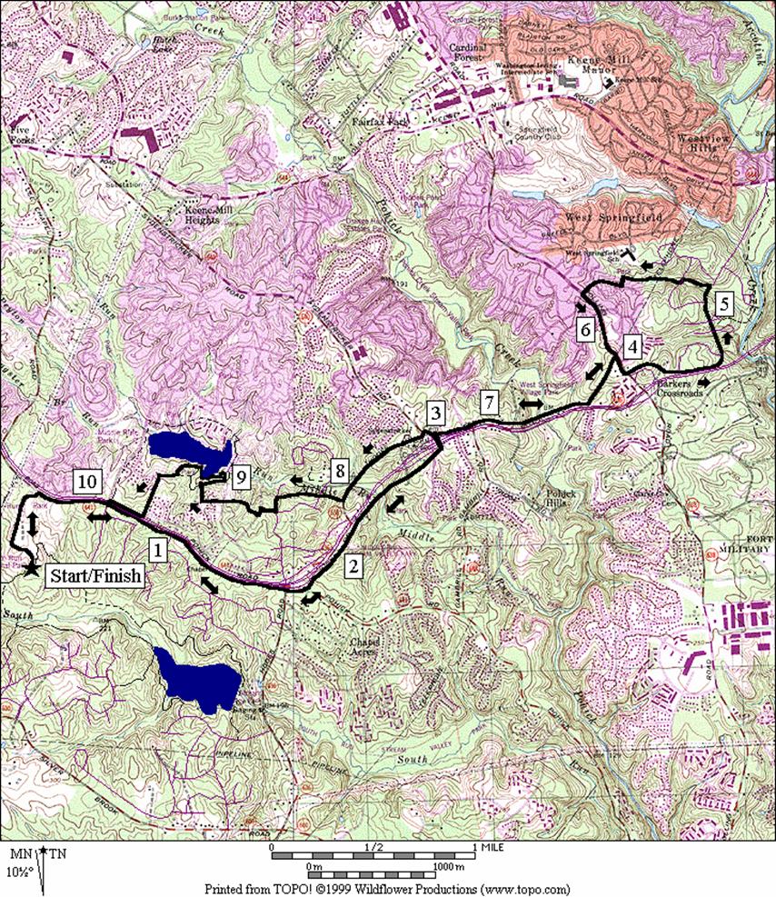
West Springfield (10.75, 6.4, or
10.3 miles, X, VII or X)
The Fairfax County Parkway
was originally designed as part of an outer beltway. Traffic lights were added and it never became
that. As is, it snakes and arcs across Fairfax
County joining the southern and
western regions. As of the year 2000,
the parkway is not completely finished, but it does run unbroken from Herndon
to West Springfield.
People can run or cycle most of this length on paved trails that
parallel it. For a trail of its size,
the Fairfax County Parkway Trail (FCPT) is sparsely used when compared to
others such as the Mt. Vernon Trail or the W&OD Trail. Of course, with it being as close as it is to
the parkway, the FCPT isn=t
as nice as those other trails. The FCPT
is sunny with almost no trees in-between the trail and the parkway. Water stops are rare and signs are lacking
at some of the few twisting turns that it takes; for instance, in the City of Fairfax. Between the City of Fairfax
and West Springfield, the trail is at its best. It rolls up and down 100-150 ft. graded hills
and if not under trees itself, it is usually surrounded by them.
This route climbs to the FCPT, then follows the trail east
of South Run
District Park. The full route goes to the edge of West
Springfield, within very short striking distance of the Accotink
Creek valley trail system. Leaving the
FCPT there, it loops back on an unpaved trail near West Springfield
Elementary School. One alternative
option to go back is to follow the trail the way you came out. The longer way uses streets and neighborhood
trails to parallel Middle Run and reach Huntsman
Lake. An attempt at making an unbroken paved trail
along Middle Run was apparently foiled by the county being unable to acquire
all the private property or right-of-ways necessary. The shortest option turns around at Shady
Palm Dr. (it becomes Syndenstricker
Rd.) where it crosses the Fairfax
Parkway, then follows the long option return route
to Huntsman Lake. Long hills, both down and up are to be
encountered no matter which way you go.
It=s generally
downhill however, when going out to West Springfield. The route crosses perpendicular to both the
Middle Run and Pohick Creek valleys before nearly reaching Accotink Creek. The FCPT is fine for bicycling. In-line skating on it east of South
Run District Park
should only be attempted by those who are exceptionally proficient with long
hills and occasional debris on the pavement.
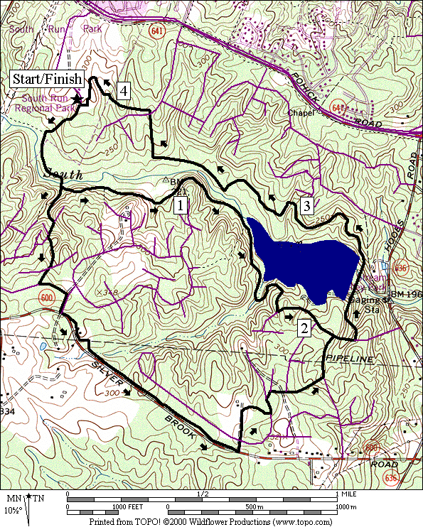
Lake Barton (11.55 or 10.7 miles,
X)
Lake Barton
is one of two reservoirs making up the head waters of Pohick Creek. Nearby Woodglen
Lake is the other. Lake
Barton had been part of the
community for years but in1999, after an unusually wet spring, and before the
onset of Hurricane Floyd, County officials had opened up flood gates. Even with the gates open, rainwater was
filling-up the lake as fast as it was emptying so during the bad weather, the
maintenance crews had to leave. Further
bad weather prevented crews being dispatched to close the gates and the lake
emptied. Angry residents, used to
feeding the geese and walking around the water with their children, suffered
the sight of cracked dry mud when extreme drought ensued all summer long.
Hopefully it will be full of water on your trip there. The waters are nice to look at even if there=s not much to drink on the route
(unless you stop in at a store). Leaving
South Run
District Park
and heading west and north on the Fairfax County Parkway Trail (FCPT) to get
there, you will climb gradually. It=s less hilly than the way heading
east. After you pass Burke
Lake Park
on the left, the trail is on Lake Haven La.
for a short way. Turning right, follow
a narrow flat paved trail along Roberts Parkway
to Burke Centre Parkway. Were you to continue along Roberts
Parkway on the narrow hilly paved trail, there are
ways to connect to Lake Barton
but they cross private property. Turn
left instead, to follow the road down toward the lake which is on the
right. The short option skips the 0.80
mile loop around it, which is on a slightly rolling paved trail. After the lake, pass the shopping center and
turn left at Ox Road,
Rte. 123, to get on the FCPT again.
After a mile, the trail returns to parallel the Fairfax
County Parkway for the trip back. Rolling hills on the treeless parkway trail
will challenge you until your reach Burke
Lake Park
again. The last leg of the route is
slightly downhill. Remember that there
is little water available on this sunny route with long straightaways.
Nearby and Connecting Zones
Pohick Creek
Prince William Parkway
Lake Accotink
What to do Afterward
Food
and Drink
Spartan=s Family Restaurant - 703 503-5800
Glory
Days Grill - 703 866-1911
Pino=s Italian Restaurant - 703 425-1889
Pacific
Café - 703 239-3838
Barbeque
World - 703 503-7100
HomeGrown
Markets - Saturdays 8AM-noon, MayBNovember;
K-Mart Center
at Burke Pkwy -
703-642-5173
Entertainment
and Edification
Hidden
Pond Nature
Center - 703 451-9588
South
Run Recreation Center
- 703 644-7070
Fountainhead
Regional Park
- boat rentals, miniature golf, hiking - 703 250-9124
Burke Lake
Distance: 7.35 miles
Rating: VI; mostly bluestone trails; one climb to the
lake and one at the end; shady
0.0 from
the parking lot follow the paved trail into the woods
0.15 trail
X on L to Lake Mercer
(unmarked)
0.3 trail
X on R (dirt) through power lines (unmarked)
0.5 pass
under Lee Chapel Rd
1.3 trail
X on R to Laketree Road
(unmarked)
L 1.35 Burke
Lake Trail at dam
1.7 Mile
Mark 4
BR 1.9 onto
trail after boat ramp
2.0 park
road
L 2.15 trail
X; L to stay on trail 60 yards after passing restrooms/water (follow sign)
2.2 park
road and Mile Mark 4.5
2.3 park
road; boat rental on R, Mile Mark 0 (water/snack bar near rentals)
2.65 trail
X on L to kiddie RR
2.7 to
amphitheater
2.8 Mile
Marker 0.5
BR 3.2 at
park road
BR 3.25 trail
continues on R after bridge
3.3 Mile
Marker 1
4.3 Mile
Marker 2
4.7 gravel
trail X on L to Fairfax County Parkway Trail (unmarked)
4.8 Mile
Maker 2.5
5.1 trail
X on L (unmarked) to gravel road & Fairfax County Parkway Trail
5.3 Mile
Marker 3
5.8 Mile
Marker 3.5
L 6.0 trail
X on L at dam follows South Run
6.05 trail
X on L to Laketree Road
(unmarked)
6.85 pass
under Lee Chapel Rd
7.05 trail
X on L through power lines (unmarked)
7.2 trail
X on R to Lake Mercer
(unmarked); go uphill
7.35 trail
ends at parking lot in South Run
District Park
Burke Shores
Distance: 5.25, 4.55, 3.5 or 1.5 Miles
Rating: V, IV, III or I; paved and unpaved
trails; climb going out and downhill on the return
5.25
Mile Route
0.0 from
the parking lot; go between the field house and pool using sidewalks and trails
toward the park exit
L 0.5 Fairfax Co Pkwy
Trail (FCPT)
<*
0.65 trail
X on L through powerlines
0.85 Lee Chapel Rd
1.05 Rolling
View Dr
<**
1.35 trail
X on L to Woodchase Dr
1.7 trail
is on the road
1.75 paved
trail continues
<***
1.85 gravel
road on L (unmarked)
1.9 Old Keene Mill Rd
on R
L 2.2 gravel
road on L; Burke Wilderness Area
2.4 trail
X on R
2.45 trail
X on L after bend in road
L 2.6 at
T; Burke Lake Trail (unmarked)
2.7 Mile
Marker 2.5
3.0 trail
X on L (unmarked)
>***
3.2 Mile
Marker 3
L 3.85 trail
X on L before dam (unmarked)
3.95 trail
X on L to Laketree Dr
>**
4.75 underpass
Lee Chapel Rd
4.95 trail
X on L from powerlines (unmarked)
>*
5.1 trail
X on R to Lake Mercer
(unmarked); go uphill
5.25 parking
lot in South Run
Park
*1.5
Mile Route
L 0.65 trail
X on L into powerlines (dirt)
L 1.2 at
T; paved South Run trail (pickup cues at mile 5.1 on 5.25 mile route)
**3.5
Mile Route
L 1.35 trail
X on L to Woodchase Dr
(unmarked)
R 1.45 South Park Circle
R 1.55 Lake Tree Dr
R/L 2.2 trail
X on R near large boulder; L onto South Run trail (pickup cues at mile 4.75 on
5.25 mile route)
***4.55
Mile Route
L 1.85 gravel
road on L (unmarked)
R 2.25 trail
X on R at bottom of hill (unmarked)
L 2.3 at
T; Burke Lake Trail (pickup cues at mile 3.2 on 5.25 mile route)
Lake Mercer
Distance: 4.55, or 5.1 Miles
Rating: IV or V; paved and unpaved trails
with some steep hills
4.55
Mile Route
0.0 from
parking follow the paved trail into the woods
L 0.15 trail
X on L to Lake Mercer
(unmarked)
<*
L 0.4 trail
X on L after crossing creek toward townhouses
0.5 trail
X on R to Thornfield Ct
1.0 trail
X on R to Bressingham Ct
1.25 trail
X on R to Hollington Pl
1.3 paved
trail ends; continue on dirt
BL 1.4 trail
splits; paved trail at 1.45
S 1.75 trail
ends at Jeffery Ct
L 1.85 Triple Ridge Rd
2.1 Bayberry
Ridge Rd on R
>*
L 2.15 gravel
trail on L toward dam; pass through cable fence
L/R 2.35 after
spillway and short steep hill; BL; R on paved trail; cross dam
L 2.55 through
gate & L at T; trail X on R
2.9 trail
X on R
S 3.15 paved
trail ends continue S on dirt trail; also trail X on L to lake
3.35 trail
leaves dyke
R 3.4 at
T; gravel road
R 3.7 Wagon
Trail Rd on R (unmarked)
CL 3.9 Huntsman
Blvd to paved trail
R/L 4.05 at end
of paved trail; R on dirt trail; L at grassy Spartan Trail around field
BL 4.35 following
Spartan Trail sign
L/R 4.5 around
field house
4.55 South
Run trail head on L

*5.1
Mile Route
S 0.65 trail
X on L after crossing creek
0.5 trail
X on R to South Oak Hollow La; trail ahead becomes gravel
R 0.6 Oak
Stream Ct (unmarked)
L 0.65 Oak
Crest La
CL 0.85 Oakington Dr
R/L 0.95 Old Barrington Dr/Silverbrook Rd
L/R 1.1 pipeline
trail; pavement ends/starts
L 1.85 Silverthorn Dr
S 2.0 trail
head at end of Silverthorn Dr
L 2.15 trail
ends; Silverline Dr
R 2.2 Tabor
La
CR 2.25 Chestnut Ridge Rd
L 2.5 Bayberry Ridge Rd
R 2.6 at
T; Triple Ridge Rd (pickup
cues at mile 2.15 on 4.55 mile route)
Huntsman Lake
Distance: 3.8 Miles
Rating: III; mostly paved trails with some
roads; modest hills; mostly sunny
3.8
Mile Route A
0.0 from
the parking lot; go between the field house and pool using sidewalks and trails
toward the park exit
R 0.5 Fairfax Co Pkwy
Trail (FCPT)
CL 0.85 Huntsman Blvd
1.05 Dorothy
La on R
1.25 trail
X on R to lake
R 1.3 Golden
Ball Tavern Ct; use shoulder and pass trail X on R to lake
R 1.75 paved
ramp/gate on R at Gold Leaf Ct
on L; becomes a trail
2.0 trail
becomes dirt after crossing dam
<*
BL 2.05 onto
paved trail
2.1 trail
X on R to inner trail
2.15 trail
X on L toward Middle Run
Steam Valley
(unmarked)
2.25 trail
X on L to houses
2.3 trail
X on L to houses
L 2.45 at
trail X
2.5 trail
X on R; basketball court
>*,
<**
L 2.6 trail
ends at court; L on paved trail leaving from court
R 2.8 Fairfax County Pkwy
XS 3.0 Huntsman Blvd
>**
L 3.35 into
South Run
Park; use roadside, gravel path and
sidewalk
3.8 South
Run trail head

*3.8
Mile Route B
R 2.05 paved
trail X (sharp R turn)
2.2 trail
X on L to outer trail
2.3 trail
X on L
R 2.55 at
T; basketball court on L (pickup cues at mile 2.6 on 3.8 mile route A)
**3.8
Mile Route C
S 2.6 Dorothy
La (unmarked)
L 2.8 Huntsman Blvd
CR 3.0 cross
the Fairfax Co Pkwy to the FCPT
(pickup cues at mile 3.35 on 3.8 mile route A)
West Springfield
Distance: 10.75,
6.4 or 10.3 Miles
Rating: X, VII, or X; mostly paved trails with
some sidewalks; long rolling hills; sunny
10.75
Mile Route
0.0 from
the parking lot; go between the field house and pool using sidewalks and trails
toward the park exit
R 0.5 Fairfax Co Pkwy
Trail (FCPT)
0.85 Huntsman Blvd
1.85 Hooes
Rd; long downhill ahead
2.5 bridge
over Middle Run; begin uphill
CL 2.9 Shady
Palm Dr to stay on FCPT
<*
CR 3.0 after
Fairfax Co Pkwy bridge;
onto FCPT
3.55 bridge
over Pohick Creek
L 3.8 at
Stream Way to stay on FCPT;
follow paved trail past basketball court
BR 3.95 at
split in trail
R 4.05 Rolling
Rd
L 4.15 at
Spring Forest Ct on R; to
stay on FCPT along Hunter Village Dr
XS 4.25 Hunter
Village Dr; to stay on FCPT
L 4.75 Hunter
Village Dr; use shoulder
4.85 trail
X on R to Accotink Creek valley
5.05 Lobelia
La
L 5.1 trail
X on L down to creek after railing
L/R 5.4 Lobelia
La; unpaved trail into woods
L 5.6 at
trail X; over metal bridge
R 5.65 Springfield Village Dr
CL 5.85 Rolling
Rd
R 6.25 paved
trail X on R
R 6.5 FCPT
at T past basketball court
6.75 bridge
over Pohick Creek
<**
R/CL 7.3 R on
Sydenstricker; CL on Hooes Rd (!)
>*
7.8 trail
X on R (dead ends)
R 7.9 Middleford Dr
8.0 trail
X on R (does not connect to lake)
CL 8.2 Seabrook Ln
R 8.3 Shadowlake Way
L/R 8.45 CL on
Bertito La; R on paved trail X on R
R 8.55 paved
trail X on R
8.6 trail
crosses Octavia Ct
8.7 trail
crosses Maritime La
8.75 trail
crosses Cervantes Ct
R 8.8 at
T; trail X (unmarked)
R 8.9 Huntsman
Lake trail; outer loop to inner
R 9.45 at
T; near basketball court
L 9.5 trail
ends at court; L on paved trail leaving from court
R 9.75 Fairfax County Pkwy
XS 9.9 Huntsman Blvd
>**
L 10.25 into
South Run
Park; use roadside, gravel path and
sidewalk
10.75 South
Run trail head/parking
*6.4
Mile Route
CL 3.0 FCPT
goes R; CL onto Hooes Rd
(pickup cues at mile 7.8 on 10.75 mile route)
*10.3
Mile Route
L 7.3 Sydenstricker
Rd; becomes Shady Palm
CR 7.4 Fairfax
Pkwy exit ramp; to stay on FCPT
7.8 bridge
over Middle Run
8.45 Hooes Rd
9.45 Huntsman Blvd
(pick-up cues at mile 10.25 on 10.75 mile route)
West
Springfield
Lake Barton
Distance: 11.55, or 10.7 Miles
Rating: X; sunny paved trails with long straightaways
and long hills
11.55
and 10.7 Mile Route
0.0 from
the parking lot; go between the field house and pool using sidewalks and trails
toward the park exit
L 0.5 Fairfax Co Pkwy
Trail (FCPT)
0.65 trail
X on L through powerlines
0.85 Lee Chapel Rd
1.05 Rolling
View Dr
1.35 trail
X on L to Woodchase Dr
1.7 trail
is on the road
1.75 paved
trail continues
1.85 gravel
road on L (unmarked)
1.9 Old Keene Mill Rd
on R
2.2 gravel
road on L; Burke Wilderness Area
2.4 trail
ends; use Lake Haven La
BR 2.7 Lake
Haven Rd ends; trail head on R
2.75 Burke
Lake Rd
R 3.15 Kamrich St on L; R
on Roberts Pkwy
R 3.7 trail
X on R; to stay along Roberts Pkwy
CL 3.8 Burke Centre Pkwy
(use shoulder)
<*
R 4.5 on
paved road through gate to Lake Barton
BL 4.65 onto
paved trail on L
R 4.75 trail
X on R; to cross the dam
R 4.9 at
T trail X; to stay on the loop trail
R 5.0 trail
X; onto wooden bridge to stay on lake loop
R 5.25 at
trail X; L is to Burke Centre Pkwy
L/R 5.3 at
T; onto Burke Centre Pkwy
sidewalk (food/water at 5.8)
>*
L 6.05 Ox Rd; onto FCPT
6.75 begin
bridge over Fairfax Co Pkwy
CL 7.0 at Robert
Carter Rd for FCPT
7.45 Fred=s Oak Rd
7.8 trail
X on R to Fournier Rd
8.15 bridge
over creek
8.4 Kamrich St on R;
Roberts Pkwy on L
8.85 Burke
Lake Rd
8.9 trail
ends; use Lake Haven La
9.15 trail
head; leave Lake Haven La
9.35 gravel
road on R; Burke Wilderness Area
9.65 Old Keene Mill Rd
on L
9.75 gravel
road on R (unmarked)
9.8 trail
is on the road
9.85 paved
trail continues
10.25 trail
X on R to Woodchase Dr
10.75 Lee
Chapel Rd
10.9 trail
X on R through powerlines
R 11.05 into
South Run
District Park;
use roadside, gravel path and sidewalks to go to parking and the South Run
trail head
11.55 South
Run trail head/parking
Lake
Barton