C&O Canal, Edward’s Ferry
Edward’s
Ferry at Lock 25 is thirty miles out from the beginning of the towpath at Rock
Creek Park
in downtown Washington. Once a ferry and a factory existed
there. Now, it’s just a quiet spot for
those launching fishing boats or visiting the towpath. Driving out there on River Road from
Washington can give you the feeling of driving to the end civilization. The road, busy in downtown Washington,
gradually becomes quieter, single lane in a few places, then finally dirt and
gravel. Watch out for the many road
cyclists on the rural sections. From the
parking area, a route in the direction of Washington goes to the McKee-Beshers
Wildlife Management Area (WMA), a flood plane managed by the State of
Maryland. Going in the other direction, River
Road itself offers an opportunity to make a loop
to White’s Ferry.
Getting
There
Take
the Capital Beltway (I-495), to the River Road (Rte. 190) headed west, outside
the beltway. After 11.5 miles, turn left
at a T-intersection to stay on River Rd.
Six-and-a-half miles later, bear right on Mt. Nebo Rd. This becomes W.
Offutt Rd. at an intersection with Offutt
Rd. on the right.
About eight tenths of a mile past the intersection, and three quarters
of a mile after a sharp bend in the road to the left, turn left at a T
intersection with Edwards Ferry Rd. At
the bottom of the hill, One and one-tenth of a mile later, bear left at the
intersection with River Rd.
and then park after crossing the C&O
Canal.
Alternatively
from Leesburg in Loudoun County, Virginia,
take Route 15 north. Turn right on Whites Ferry Rd.
a mile after the intersection of the Route 15 business and the Route 15 bypass
routes. Pay the toll ($3) and cross the
river (The ferry gives you a chance to imagine a slower life on the river. View
the river plants swaying in the gentle waters.
The trip takes only 5 minutes).
After crossing the canal, turn right on River
Rd., a dirt and gravel road. After 3.7 miles, turn right again to stay on River
Rd. at the intersection with Elmer
School Rd.
Finally go 1.35 miles more, bear right on Edward’s Ferry
Rd., cross the canal again and park.
Area
Routes
Sycamore Landing
(10.75 miles, IX)
Sycamore
Landing Rd. is an
alternative way of looping through the McKee-Beshers WMA. From Lock 25, at Edward’s Ferry
Rd. take the C&O towpath toward Washington. Pass Chisel Branch campground. Water from pumps at all campgrounds on this
route should be treated before being used for drinking. The stretch of the towpath used on this route
and most of that included on the White’s Ferry route is best described as a
flat tunnel through a forest. Trees
almost continually canopy overhead. Few
landmarks breaks it up so if you’re into meditative aspects of running or
riding, you’ll enjoy this. Pass Sycamore
Landing Road on the left. You will return on it. Turn left at Horsepen Branch campground onto
a dirt trail that leads from the water pump.
It in-turn leads to a double-track.
Puddles in wet seasons can make it difficult to navigate long after a
rainfall. Hunting is also allowed in the
WMA during the fall. After passing the
large ponds frequented by much waterfowl, turn left on Hunting Quarter Road,
another gravel road, but one open to auto traffic. Climb a small hill on Hughes
Rd. to River Rd,
and briefly use the shoulder to get to Sycamore Landing Rd. Sycamore Landing
Rd. is a gravel road on the edge of the WMA.
At the parking area at the end of the road, pass through the gate and
turn right on the C&O towpath to return to Edwards Ferry Rd.
Whites Ferry (10.0 or 2.35
miles; VIII or I)
This
route uses a long dirt and gravel stretch of River
Road, and the C&O towpath, to make a loop between
Edward’s Ferry and White’s Ferry. The portion on River Road is mostly across
open fields and some turf farms. It has
some long gradual hills and contrasts sharply with the flat tree covered
towpath. White’s Ferry is still
operational and a parking lot near the towpath there can be used as an
alternate starting point. Drinks and
snacks can be purchased at the ferry. An
optional short route uses a National Park Service horse trail to connect River
Road and the towpath. The footing on the
horse trail which crosses park land, can be rough from dried-up horse hoof
prints left on muddier days.
Nearby
and Connecting Zones
C&O Canal, Riley’s Lock
W&OD, Leesburg
Taylorstown, Virginia
What
to do Afterward
Food
and Drink
picnic
Leo's
Place - Poolesville, MD - pizza and sandwiches - (301) 972‑7443
White’s
Ferry - 301 349-5200
Entertainment
and Edification
White’s
Ferry - an operational ferry over quiet waters of the Potomac
takes people to Leesburg - 301 349-5200
Historic
Leesburg, Virginia
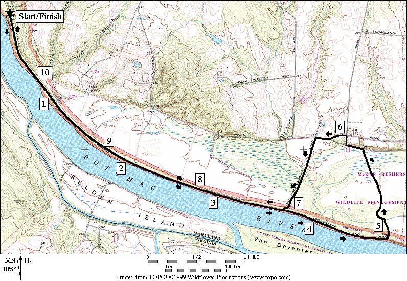
Sycamore Landing
Distance: 10.75 miles
Rating: IX; flat dirt roads and towpath
10.75
Mile Route
R 0.0 from
Edward’s Ferry Rd at Lock
25
0.35 Chisel
Branch campground
0.85 mile
marker 30
1.9 mile
marker 29
2.9 mile
marker 28
3.7 parking
for Sycamore Landing on L
3.9 mile
mark 27
4.1 bridge
over creek
L 4.8 trail
X on L at Horsepen Branch camp; trail is near water pump
BL 5.15 onto
double-track dirt road (unmarked); go straight at all intersections
L 5.7 Hunting
Quarter Rd at T after gate (unmarked gravel road)
R 5.85 Hughes
Rd (unmarked)
L 5.95 River
Rd (use shoulder)
L 6.25 Sycamore
Landing Rd (gravel)
R 7.1 through
gate at end of road and onto C&O towpath
7.85 mile
mark 28
8.85 mile
mark 29
9.9 mile
mark 30
10.4 Chisel
Branch campground
10.75 Edward’s
Ferry Rd at Lock 25
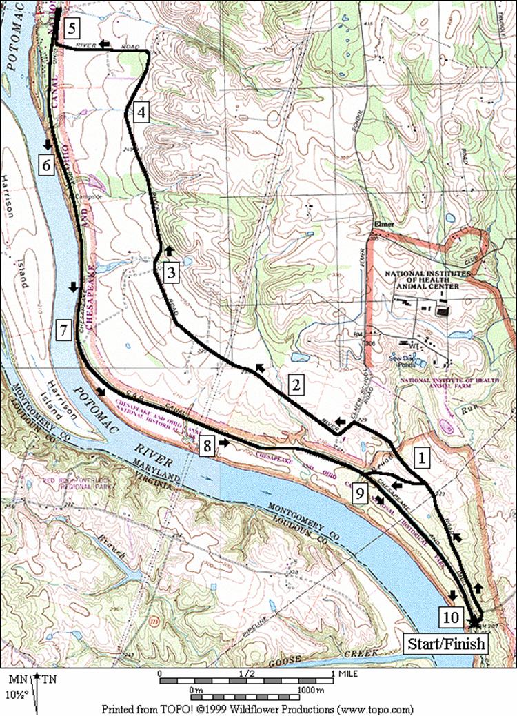
Sycamore Landing
White’s Ferry
Distance: 10.0 or 2.35 miles
Rating: VIII or I; gravel roads across fields
w/gradual hills, dirt flat and shady towpath
10.0
Mile Route
0.0 from
Edwards Ferry Rd at Lock 25 follow the road away from the river
L 0.1 River Rd
0.8 gas
pipeline crossing clearing
<*
0.9 trail
X and gate on L (NPS horse trail)
1.15 bridge
over Broad Run creek
L 1.45 at
T to stay on River Rd; Elmer School Rd on R
1.95 pipe
bridge for stream
2.35 power
lines
3.05 turf
farm main entrance
4.0 pipe
bridge between fields
4.9 trail
X on R
L 5.1 White’s
Ferry Rd (snacks and drinks
at Whites Ferry at river, 0.1 ahead)
L 5.1 C&O
Canal towpath; iron trestle and stone bridges (alternate parking)
5.6 mile
marker 35
6.2 campground
(treat water pump water before drinking)
6.55 mile
marker 34
7.05 bridge
7.5 mile
marker 33
7.9 power
lines
8.85 mile
marker 32 (long mile)
8.9 bridge
over Broad Run trunk and canal stonework
8.95 trail
X on L horse trail
>*
9.25 gas
pipeline; view across river to golf course
9.85 mile
marker 31
10.0 Edward’s
Ferry Rd at Lock 25

*2.35
Mile Route
L 0.9 gate
and trail X on L (dirt NPS horse trail)
L 1.25 C&O
canal towpath (pickup cues at mile 9.25 on 10.0 mile route)