Historic Frederick Maryland
For
years, while on the way to hiking or cycling opportunities, I used to pass by Frederick
on I‑270 and Rte. 15 seeing the shopping malls, strip-malls, suburban
housing and apartments. I didn=t think Frederick remarkable in any way
but knew that Maryland=s
fastest growing city in the 1990's, had beautiful countryside and mountains
surrounding it. I even rode the covered
bridge road bike rides by starting out off Rte. 40 inside the city limits but
my opinion remained unchanged. I never
saw how nice the historic downtown area was and had to be told about it by
friend who happened to visit it because she was new to the area and was
exploring. Subsequent visits such as on
Cycle Across Maryland stops, put it on my list as a place to go to, and not
just pass through. The downtown area is
alive. People work and live nearby. Fabulous restaurants, ice cream and specialty
stores line Market Street. You can get real milk shakes or Italian ice;
vegetarian, international or American cuisine. Granite rough cut stone buildings
give the place character. The city is
more than just a tourist stop, functioning with classic American buildings such
as city hall, a courthouse and railway stations.
Only
one short route is listed here but many other places for getting outdoors are
nearby. Gambrill
State Park, a favorite of mountain
cyclist and hikers sits on the mountain overlooking the city. The Monocacy
River flows nearby attracting
fishers. The old Point of Rocks train
station lies to the south on the Potomac River. It=s
a favorite of train buff=s
but also a gathering place for road cyclists.
Catoctin Mountain
State Park lies to the north near
Thurmont. Hikers at Catoctin love the
autumn leaves, water fall and rock formations with mountain top views.
Getting
There
From
the Capital Beltway (I-495), take National Pike I-270 headed west. As you approach Frederick
31 miles from the beltway, stay to the left as I-70 splits away to the
right. The highway turns north and
becomes Rte. 15 after the I-70 intersection.
Just ahead, take Exit 7, for Rosemont Ave. At the exit ramp light, drive straight across
Rosemont Ave. This becomes West 2nd
St. Park
near the intersection of West 2nd and Dulaney
Ave. just off Baker
Park.
Area
Route
Baker
Park (1.9 miles, I)
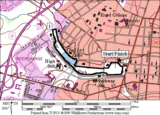
For
a small town, Baker Park
is a big place. In it are walking and
running trails, an outdoor amphitheater for concerts and plays, a fountain, a
stream, a covered bridge, tennis courts, a public pool, ponds and fields. In winter, ice-skaters warm themselves in a stone
building right on the water. Intermural
or pick-up soccer and volleyball games are played in the fields in summer. Hood
College is nearby. The towering stone armory building points the
way toward Market Street. Beautiful old homes line streets around the
park. The route circles the park passing
these features on the paved but often narrow trails. No bicycling is allowed. The terrain is basically flat though it does
rise as it parallels a stream on the out-leg of the route.
Nearby
and Connecting Zones
Little Bennett Regional Park
Black Hill Regional Park, Little Seneca
Lake
Black Hill Regional Park, Ten Mile Creek
What
to do Afterward
Food
and Drink
Rita=s Italian Ices - Rita's Italian Ice -
(301) 694‑8834
Casa
Pizza - 234 N. Market St -
(301) 695‑8402
Di
Francesco's Restaurant - 26 N. Market St
- (301) 695‑5499
Orchard
Restaurant - 45 N. Market St
- (301) 663‑4912
Entertainment
and Edification
Covered
Bridges - 2 remaining, the nearest is on Utica Rd.
near Lewistown
Gambrill
State Park - hiking
Cactoctin
Mountain Park - hiking - 301 663-9388
Cunningham
Falls State Park
- 301 271-7574
Baker Park
Distance: 1.9 miles
Rating: I; flat paved trails; partial tree
cover
1.9
Mile Route
0.0 from
2nd St and Dulaney
Ave, take the diagonal trail from 2nd
toward the amphitheater
0.1 pass
through the fountain area after the amphitheater
0.15 trail
bears R at creek & dam
BR 0.25 at
trail X toward the underpass
0.3 tunnel
under College Ave begins
BR 0.35 at
trail X to go along creek
0.45 trail
X on L to suspension bridge
0.6 W
College
0.75 trail
X on L toward high school; pond on R
BL 0.75 trail
X on L; R goes around pond
0.9 covered
bridge on L
R 1.0 Fairview Ave
R 1.05 W 2nd St
sidewalk
1.2 water
1.3 trail
X on R from pond loop merges
R 1.35 trail
X on R at ice skater=s
stone shelter; water is just past the turn
L 1.45 at
trail X; cross W College to path along Fleming Ave
1.55 trail
X on R between tennis and pool
1.75 cross
College Ave following trail
around tennis courts on L
BR 1.85 W 2nd St
sidewalk
1.9 trail
X on R toward amphitheater completes loop near Dulaney
Ave